![]()
![]()
![]()
5.1 Global Precipitation Climatology Centre
The Global Precipitation Climatology Centre (GPCC) is operated by the Deutscher Wetterdienst (DWD, National Meteorological Service), located in Offenbach, Germany, under the auspices of the World Meteorological Organisation (WMO). The Centre was established in 1989 and contributes to the World Climate Research Programme's (WCRP) Global Precipitation Climatology Project (GPCP) and the Global Climate Observing System (GCOS).
The general task of the GPCP is the compilation of global gridded precipitation data sets based on observational data. The products are designed for the global climate research community and are especially required for:
Verification of global climate models
Investigation of climate anomalies, variability and special phenomena such as the El Niño - Southern Oscillation
Study of the global water balance.
The scientific and technical functions of the GPCC are defined by the 'Implementation and Data Management Plan for the Global Precipitation Climatology Project' (WMO/TD-No. 367) and comprise:
Acquisition, reformatting and storage of in situ observed precipitation data
Monitoring of the data availability
Quality-control, flagging, and correction of the data
Calculation of monthly area-mean precipitation on a grid for land-surface based on conventional measurements
Error assessment, estimation of the accuracy of the product, with regard to systematic measuring errors, data coding and transmission errors, sampling errors (station density), and methodical errors (analysis)
Participation in merging of satellite and raingauge data of GPCP and in the further development of the method
Development of advanced quality control and analysis techniques
Dissemination of the products and research results to the scientific community.
To date, GPCC has collected monthly precipitation data from about 40,000 stations world-wide. Data from 7,000 stations are routinely updated and analysed near real-time. The other data are delivered in delayed time from 150 countries on a voluntary basis. The data collection of GPCC is primarily based on direct sources (contacts to the operators or official data centres) and is logistically supported by the WMO. But the GPCC also co-operates with other groups (as of Climate Research Unit, Norwich/UK, and of NCDC, Asheville/NC) in order to complete the database. The delivery and data processing of the large data amounts causes serious delays in the analysis.
The global gridded products, i.e. the gridded satellite-raingauge combined monthly precipitation data set of the GPCP (resolution 2.5° by 2.5°, 1979 to present) and the raingauge-based monthly analyses of the GPCC (resolution 2.5° by 2.5°, 1971 to 1994, and 2.5° by 2.5°, 1986 to present) are accessible via Internet. Due to the interest of the data originators (owners), the point precipitation data obtained by the GPCC cannot be made available. More information on GPCC is available at <http://www.dwd.de/research/gpcc/>.
5.2 Global Runoff Data Centre
The Global Runoff Data Centre (GRDC) has been established at the Federal Institute of Hydrology in Koblenz, Germany in 1988. Operating under the auspices of WMO, the principal objective of the GRDC is to collect and disseminate hydrological data to support projects within the World Climate Programme (WCP) and the World Climate Research Programme (WCRP) of WMO as well as for other programmes. With regard to GRDC, the Twelfth Congress of WMO adopted Resolution 21 (Cg-XII) which encourages Members (countries) "to support the GRDC through the provision of the hydrological data and related information that it needs".
GRDC provides a mechanism for international exchange of data pertaining to river flows on a continuous, long-term basis. The scope of data collection is global, regional and river basin- scale. The Centre employs a state-of-the-art Database Management System that ensures rapid data entry and retrieval services, complex queries, and fast response to data requests. So far, 147 countries contributed to the development of the database, which now consists of data from over 3800 stations monitoring about 2900 rivers world-wide. The database is being continuously updated. More information on GRDC is available at <http//:www.bafg.de/grdc.htm>.
5.3 UNEP GEMS/Water Collaborating Centre
The GEMS/Water Programme, which operates as the global water quality monitoring arm of the United Nations Environment Programme (UNEP), can bring the needed water quality information to a global hydrological network. The GEMS/Water Collaborating Centre in Burlington, Canada has for many years collaborated with GRDC on areas of common interest. The strength of this existing partnership can be brought forward in the design and establishment of the hydrological network.
The UNEP GEMS/Water Collaborating Centre in Canada undertakes a programme to achieve four major objectives:
1. Maintenance and expansion of the GEMS/Water global database
2. Expansion and development of the GEMS/Water monitoring network for water quality
3. Capacity building of water quality monitoring capabilities in developing countries
4. Water quality assessments at the global and regional scales in co-operation with other UN agencies.
To meet these objectives the GEMS/Water Collaborating Centre operates the global water quality data bank located at the Canadian National Water Research Institute; undertakes analysis, assessment, and interpretation activities; implements capacity building activities through country missions; and initiates training activities in conjunction with the United Nations University (UNU).
UNEP GEMS/Water operates world-wide, maintaining collaboration with WHO, WMO, UNESCO and other organisations and agencies which bring their expertise together on international activities. GEMS/Water operates and maintains a global water quality database comprised of data received from the participating national monitoring programmes. Approximately 100 countries are currently listed as participants. Since 1998, the number of participating and active countries in GEMS/Water has increased by 20 percent; the growing interest and activity reflects the rising importance placed upon water quality issues around the world. Expanded details of the structure and activities of the UNEP GEMS/Water Programme are provided in Annex III of this report. More information on UNEP GEMS/Water is available at <http//www.cciw.ca/gems>.
5.4 IAEA/WMO - GNIP
The Global Network for Isotopes in Precipitation (GNIP) is operated by the Isotope Hydrology Section of the International Atomic Energy Agency in Vienna, Austria. This world-wide survey of the isotopic composition of monthly precipitation started as early as 1961 in co-operation with WMO to study the raising Tritium levels in the atmosphere caused by nuclear weapon tests. The programme also aimed to provide systematic data on the global stable isotope content of precipitation as a basis for the use of environmental isotopes in hydrological investigations. It was soon recognised that the collected GNIP data are also useful in other water-related fields like climatology, oceanography and hydrometeorology.
GNIP reached its maximum in the early 1960s with 220 operative stations. Currently more than 180 stations are in operation from a total of 530 stations in the GNIP database. More than 30 percent of all isotope analyses are performed at the IAEA Isotope Hydrology Laboratory, while the others are measured in more than 30 collaborating laboratories. Altogether >100000 isotope measurements were performed within the GNIP. All the operation is done on a voluntary basis both by the sample collecting meteorological stations and by the analysing laboratories. In the past the data were published regularly in IAEA data books. For several years the whole database has been available on line from the IAEA GNIP homepage (http://www.iaea.org/programs/ri/gnip/gnipmain.htm). Details on GNIP are provided in Annex III.
5.5 WHYCOS
The World Hydrological Cycle Observing System (WHYCOS) was launched by WMO in 1993 with the aim of promoting co-operation in the collection and exchange of hydrological data at the river basin, regional and international levels and in developing products of interest to the participating countries. WHYCOS is being developed through a series of regional (HYCOS) projects, each of which includes a network of 40-50 Data Collection Platforms (DCP) reporting in real-time. Currently, some twelve projects are at various stages of implementation or development. In the spirit of WMO Resolution 25 (Congress XIII, 1999), the exchange of data collected within the framework of each HYCOS project is a pre-condition agreed to by the participating countries. Data from the projects in the Mediterranean basin and in Southern Africa are now accessible on the Internet. Information on the status of the various HYCOS projects is provided in Annex III.
WHYCOS is global in concept, but implemented on a regional basis. Reporting frequency is daily or shorter (3-hourly), thus providing near real-time access to data. At present, MED-HYCOS and SADC-HYCOS are reporting, and within the next 3 years three or four other operating HYCOS projects will also be active. More information on WHYCOS is available at < http://www.wmo.ch/>.
5.6 FRIEND
The collection of hydrological and related data in FRIEND (Flow Regimes from International and Experimental Network Data) is conducted in the framework of regional projects. Data collection is tailored to meet science needs defined in FRIEND working groups. Regional data centres store the data that are available to scientists collaborating in FRIEND projects. The amount of data varies largely from region to region. For example, the data archive of FRIEND Northwestern Europe contains hydrological records from more than 5000 stations. The majority of data is collected from small river basins. Access to data is based on rules established by the FRIEND networks, but one of the conditions is to contribute new data or 'added-value' science to enhance the understanding of high and low flows.
A presentation on the FRIEND project was made by Dr Grabs on behalf of Dr Bonell from IHP/UNESCO. The meeting participants discussed the presentation and the strong scientific underpinning of the programme. Participants felt that regional FRIEND projects should review their data dissemination policy to make the data and information useful within the framework of a global hydrological network, which requires free and unrestricted access to hydrological data and information. The meeting noted that some FRIEND projects tend to have a more liberal approach to this issue than others do. The participants recommended that regional FRIEND co-ordinators should be briefed about results of this meeting and that requests be issued to share selected data from FRIEND networks. More information on FRIEND is available at http://www.pangea.org/orgs/unesco/friend/.
5.7 GEWEX
A major goal of GEWEX is better understanding of the global hydrological cycle so as to enable an improved prediction of weather and climate, climate variability, and the availability of water resources. At the core of GEWEX are the Continental Scale Experiments (CSE). Data is held in distributed data centres and archives. In a planned Co-ordinated Enhanced Observation Period (CEOP), GEWEX will achieve an array of simultaneous, consistent set of observation of a large variety of hydrological, meteorological and energy flux variables. CEOP will ultimately allow the integration of global observations in the CSEs in regional and global scale prediction models. More information on GEWEX is available at http://www.gewex.com/.
5.8 HELP
A presentation on the HELP project was made by Dr Grabs on behalf of Dr Bonell. HELP is a joint UNESCO/WMO programme that is designed to establish a global network of catchments to improve the links between hydrology and the needs of society. It is a crosscutting programme of the UNESCO International Hydrological Programme, and will contribute to the World Freshwater Assessment Programme as well as the Hydrology and Water Resources Programme of WMO.
The vital importance of water in sustaining human and environmental health is the key driving force behind HELP. However, no international hydrological programme has addressed key water resource issues in the field and integrated them with policy and management needs. HELP will change this by creating a new approach to integrated catchment management. The new approach is to use representative catchments with real water related problems as the setting within which hydrological scientists, water resources managers and water law and policy experts can work together. HELP is therefore a problem-driven and demand-responsive initiative that will focus on the following eight key issues:
Water and food security
Water quality and human health
Water and the environment (environmental health)
Water and potential conflicts
Impact of climate variability on water resources
Improved communications between hydrologists and society
Water-related disaster prevention and mitigation (flood control, drought management)
Water for socioeconomic development.
The outputs of HELP will be new data for better process understanding of water transfer into, through and out of drainage basins (104 km2 or larger), linked with models that are more suitable for the revision of current water policy and water resources management practices in the above eight areas. More information on HELP is available at http://www.nwl.ac.uk/ih/help/index.html.
The group noted several areas of common interest, in particular with regard to climate change and variability, improved weather forecasts, and sustainable development. In this respect, HELP could become an important user of global hydrological network services in the future. The participants realised that the concept of HELP has not yet materialised into specific projects or activities to which direct links could be established, but this is expected to take place from 2001 onward.
In Asia, two major projects, the Pacific region FRIEND and the GAME are being carried out. These projects promote the mutual data exchange and will contribute to the initiation of a global hydrological network in the region. The data obtained in the co-operative intensive observation period (1997, 1998) of GAME are now being analysed by the researchers who joined the project and will later become open to other researchers.
5.9 TEMS
The Terrestrial Ecosystem Monitoring Sites (TEMS) database was created in the mid-1980s by the Global Environment Monitoring System Programme Activity Centre (GEMS/PAC) of UNEP in Nairobi, Kenya. It was built as a register of terrestrial observation sites which access, measure, monitor and catalogue ecological data.
During the planning phase of GTOS (1993-1995), TEMS served the internal needs of GTOS but a number of requests were received to make the database more generally available. In 1994 the Swiss Federal Institute for Forest, Snow and Landscape Research (WSL) offered to manage and develop the TEMS database for GTOS. Since then, WSL has improved the available metadata, refined many of the tables, expanded the original database from approximately 150 sites to the present registered 700 sites, developed a user interface, and made TEMS accessible via the Internet. The following criteria have been applied to include sites into the TEMS database:
The participating sites focus on activities directly relevant to one of the five key GTOS priority areas
The participating sites actively collect, archive, and/or distribute environmental data on terrestrial/coastal ecosystems
The participating sites have a stated interest in international collaboration that is tangible and includes responsible individuals who are committed to this orientation
The participating sites have a reasonable history of terrestrial observations and/or security of long-term tenure and funding
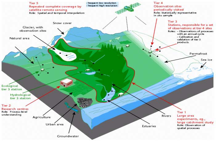
The participating sites either individually or collectively contribute to one or more levels in the Global Hierarchical Observing Strategy (GHOST; GCOS/GTOS, 1997).
Figure 1. GHOST Tier Structure
At its annual meetings in 1998 and 1999, TOPC reviewed the metadata base structure, and proposed several innovations for a new version of TEMS. Subsequently, a second version of TEMS was designed and prepared in MS-Access97 format at the GTOS Secretariat to include the following additional features and functions:
Reduced set of environmental variables (from 530 to a core set of about 150) to cover the five GTOS issues listed above (except for toxics and pollution (planned)). Each variable has been classified as physical, chemical or biological
Inclusion of socio-economic variables (common for all GTOS issues)
Inclusion of definitions, rationale for measurements of these variables, methods and other ancillary information regarding the variables
Links of variables and sites to GTOS issues, programmes (such as NPP and TCO), Conventions (climate change, biodiversity, desertification) and GTOS thematic networks
Development of a set searchable maps (country boundaries, ecoregions, land cover etc.)
Advanced query system (using Boolean operators i.e. AND, OR, NOT) with multiple criteria search
Improving the resolution of the co-ordinate range for site location and search from degrees to seconds.
The site manager address, telephone, email etc. are available for further information preparation of French and Spanish versions (planned)
Links to the WMO/GCOS database on satellite sensors/missions of interest for space-borne measurement of certain variables (planned).
In addition, all the 700 sites registered so far have been re-contacted to update information on their sites; new questionnaires have been developed for this purpose. The re-registration is presently in progress. The present Access version of TEMS will be available on CD-ROM. An Oracle version of TEMS is in preparation and will be accessible via Internet. Site managers will then be able to update information on their sites through remote access.
![]()
![]()
![]()