![]()
![]()
![]()
In section 4., the major applications requiring hydrological observations were identified. To meet these observation requirements, a capability must exist to evaluate requirements and to acquire, assemble and make available global data sets of hydrological observations. This capability should be able to deliver observations with the appropriate spatial resolution, observational frequency, timeliness, and quality. It is proposed that these roles be met by a Global Terrestrial Network for Hydrology, GTN-H. This network would complement other existing global terrestrial networks grouped under GT-Net (http://www.fao.org/GTOS/PAGES/Gtnet.htm), namely GTN-G for glaciers, GTN-P for permafrost, and GTN-E for ecosystem observations (see also section 2.3, 2.4).
The primary users of GTN-H products will include international conventions (Framework Convention on Climate Change, Convention on Biological Diversity, Convention to Combat Desertification); global observing systems; major water-related programmes and initiatives of the United Nations; the research community with focus on national to global scales; and regional and national agencies concerned with climate change impacts and sustainable development. As discussed in more detail below, the network would initially be formed through an association of existing data acquisition networks, data assembly facilities, and product generation centres; new capabilities would be added as and where required and feasible.
7.1 Functions
GTN-H is envisioned to have the following functions:
Promote and monitor making of the required observations, monitor their quality and ease of delivery and advise co-operating institutions so that the observations are responsive to and consistent with the evolving user needs
Provide timely access to hydrological metadata and to the data needed to generate products
Generate or facilitate the generation of relevant products and the related documentation, satisfying timeliness and quality requirements of users
Promote standardisation of observations and the use of best practices
Provide access to data and products within the existing framework, such as WMO Resolutions 40 and 25
Obtain user feedback, and ensure responsiveness to it and to changing needs within the diverse user community.
In general, GTN-H activities will concentrate on hydrological data and products, including data acquisition and assembly; product generation, distribution and archiving; etc. However, GTN-H must also be linked with, and responsive to, a broader framework, both thematically and organisationally. For example, from a climate perspective the main objective is to observe regional and local changes in hydrological variables that respond to or force climate, directly or indirectly, and to understand the processes by which these variations occur, rather than documenting climate change detection per se.
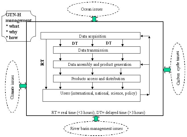
Figure 3 illustrates some of the GTN-H functions and feedback loops. An important distinction needs to be made on the basis of timeliness of data delivery. Real-time hydrological data are needed continually for numerical weather prediction, for some aspects of seasonal climate forecasting, as well as for assessment of hydrologic conditions when anticipating hydrologic hazards such as flooding. These measurements can be assimilated directly into the models, thus requiring no further assembly or generation of products. The data can now be made available primarily through GTS, a system established and operated to support the World Weather Watch Programme of WMO, NWP and related applications. However, it may be feasible to also use the Internet for data transmission such as currently done nationally by the USGS; this aspect would require careful analysis of the implications for global distribution. As Figure 3 indicates, products requiring assembly, screening and processing of the original observations are produced in delayed time, with the length of delay varying depending on the nature of the product as well as the data handling capabilities.
In general, GTN-H is concerned with the terrestrial portion of the global water cycle, that is, the movement of water on, above and below the earth's surface. Therefore, it must interface with other aspects of the earth system: energy fluxes and biogeochemical cycles, notably the global carbon cycle and its terrestrial component; terrestrial sediment flux processes; the oceanic, atmospheric, and cryospheric parts of the global water cycle; and the earth's climate. For the same reasons, GTN-H evolution needs to include consultation and collaboration with programs and agencies that are concerned with these aspects of the earth system.
Figure 3. The General Context and Data Functions of GTN-H
7.2 Attributes
GTN-H is envisioned to have the following major characteristics:
It will be a cluster of networks, created through collaboration of existing networks where possible. Only in specific areas where requirements are not met or significant observational gaps exist would additional capabilities be established;
Its domain is global, thus must ensure consistent global coverage. The global framework will be structured to accommodate regional to national enhancements as desired, e.g. in spatial or temporal resolution, variables observed, etc. Over time, it will strive to increase the coherence among the participating networks, particularly through collocation of observing sites and through consistent measurement protocols;
It will take maximum advantage of existing sites, data and product centres, and hydrological services;
It will consider the production of global products for hydrological variables as its major goal;
It will stress accumulation of coherent multivariate data sets which are necessary for the understanding of hydrological and climatological processes, as well as the assessment of resource sustainability;
Its products and compilations will be available without restriction.
It is suggested that the spatial context of individual sites in GTN-H be established using global site - specific data sets with designated hydrologic connectivity between sites as well as global gridded data sets, with the grid cell size chosen in relation to the requirement as well as to the data type(s) under consideration. Normally, the various grid sizes would be nested, giving flexibility in scaling and data handling. The catchment topology (stream networks, watershed boundaries, topography, land cover and land use distribution) can also be readily accommodated through co-registered overlays. These various GTN-H attributes can be readily linked once placed in a geographic context, and existing information processing tools (e.g., geographic information system software) can be used to achieve efficient data utilisation. Initial steps in this direction have been taken by GRDC and UNH (see also section 6.1 and 6.12). The various levels of observation intensity at individual sites can be accommodated through the tier concept of the Global Hierarchical Observation Strategy (GHOST; GCOS/GTOS, 1997).
7.3 GTN-H Components
It is envisioned that GTN-H will consist of several components, which are necessary to carry out the functions identified in section 7.1 and illustrated in Figure 3. Figure 4 considers these from the perspective of the existing networks and proposed participating agencies. A number of the hydrological variables of interest are presently being collected (section 6.), and a subset is being made available. Most of the data collection takes place at the national level, executed and funded by national hydrological or meteorological agencies. To various degrees, these data are presently assembled by international centres to generate global or regional products (section 6.). Figure 4 indicates that these centres are at various stages of evolution. For some variables (discharge, precipitation, snow water equivalent, isotopic composition of precipitation, BGC fluxes into oceans, vapour pressure) such centres and associated data access mechanisms exist; in these cases, some products are being generated and others are feasible during the initial phase of GTN-H establishment. For other variables (evapotranspiration), data collection is underway and centres for data use exist, however data access is not well developed. For the remaining variables (surface water storage fluxes, ground water fluxes, soil moisture, water use), the main problems are inadequate data collection, difficult access to relevant information, lack of data handling centres, or a combination of these. Figure 4 also shows the centres that are sufficiently developed and active to become effective GTN-H contributors from the outset. These issues are addressed further in the discussion on GTN-H implementation plan (section 7.5) and recommendations (section 8.).
To ensure success of the GTN-H, an end-to-end approach needs to be adopted for its planning and implementation. The term "end-to-end" management of data and information describes a process rather than a sequence of actions. In particular, it implies the establishment of a feedback loop between the providers of data and information and the user of the information (Figure 3).
Figure 4. Proposed Initial
Configuration of GTN-H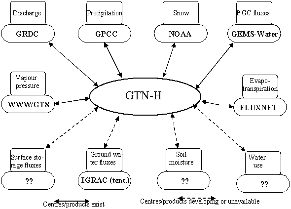
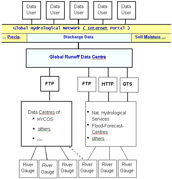
The specific arrangements for data flow are likely to differ based on the type of data, the characteristics and capabilities of contributing sites and networks, and the timeliness requirements. As an example, Figure 5 shows the potential use of the Internet for handling the access to runoff data and the derived products.
State - of - the - art information systems and communication technology are at the heart of the proposed GTN-H. Information will also flow from/to GOSIC, INFOCLIMA, INFOHYDRO and INFOTERRA. In the development of the GTN-H it is essential to establish linkages with existing data centres. This is particularly important where additional data and variables are the subject of related programmes and projects such as water quality and isotopes in hydrology.
Figure 5. A Scenario for GTN-H Data and Product Delivery via Internet
7.4 Hydrological Observation Panel for Climate
Three global observing systems have been established in the 1990s to enable systematic, long-term observation and assessment of the earth system in general, and the role of climate in particular: the Global Climate Observing System (GCOS, 1995; http://www.wmo.ch), the Global Ocean Observing System (GOOS; http://ioc.unesco.org/goos/goostoc.htm); and the Global Terrestrial Observing System (GTOS, 1998; http://www.fao.org/gtos). These are in addition to the World Weather Watch (http://www.wmo.ch) and other WMO programs which have been in existence for many years and which provide the relevant atmospheric observations. Each of these observing systems encompasses space and in situ observations, and each is organised to maximise the efficiency and effectiveness of making the observations for global as well as regional applications.
The overall direction for the development of each global observing system is provided by a steering committee. In turn the scientific input to the steering committee as well as some implementation activities are the mandate of scientific panels established as part of the programs. Since from the scientific as well as organisational perspectives many of the observation issues are very broad, the implementation of the global observing systems must be approached through close collaboration with other activities in the observation and scientific communities. This is dealt with by ensuring broad representation of observation and research agencies in the steering committees, and by co-sponsorship of the science panels. In general, these panels are sponsored jointly by two or more international programs. The terms of reference for the panels are defined by the panel's co-sponsors, and the panels report to all the sponsoring organisations. The co-sponsorship helps ensure that the various programs are co-ordinated at the scientific and technical levels, and that the advice provided to the steering committees has been formulated in the broad context of related activities. In this way, the science panels are responsible to the major international programs that are relevant to the panels' work. In the terrestrial domain, two science panels have been established for the Global Terrestrial Observing System so far: the Terrestrial Observation Panel for Climate (TOPC) in 1995 and the Global Observation of Forest Cover (GOFC) Panel in 2000.
Since hydrology issues concern mainly the terrestrial environment, TOPC has been the panel responsible for these on behalf of GCOS and GTOS. Its activities included an initial analysis of the observation issues and identification of critical variables (GCOS, 1997), definition of satellite observation requirements (TOPC, 1998), and others (GTOS, 2000). However, there are other important hydrological issues beyond TOPC terms of reference that are relevant to GTOS' five themes, especially sustainable availability of water resources and pollution/toxicity (GTOS, 1998). These have been dealt with to some extent by TOPC (TOPC, 1999) but only at a general level. Application areas discussed at this workshop (section 3., 4.) have confirmed the importance of the non-climate issues in the terrestrial hydrological domain, and have highlighted the urgent need for more focused attention to this area.
An important task of the science panels is to contribute to the initial implementation of the observing systems. Thus, TOPC has led the establishment of global in situ observing networks, initially built by co-ordinating activities of existing networks and engaging these in systematic global observation. Three such networks have been established so far (TOPC, 1999) that focus on ecology <http://www.ilternet.edu/>, glaciers <http://www.geo.unizh.ch/wgms/>, and permafrost <http://sts.gsc.nrcan.gc.ca/permafrost/gtn-p.htm>. Similarly, GOFC has developed regional networks as part of its implementation (Figure 6). This expert meeting developed the framework for a similar network in hydrology but it also identified a number of critical issues that require scientific guidance and initiative. Previous experience from the global observing systems demonstrates that scientific advice is a critical element of success for the observation networks and of the products the networks generate.
Based on the above considerations, it is proposed that in addition to GTN-H, a Hydrological Observation Panel for Climate (HOPC) be established as a new science co-ordinating panel with an advisory function. Its terms of reference might be patterned TOPC (Annex IV.), with due considerations to hydrology-specific science and organisational aspects as well as the present situation, programs and concerns. In particular, they need to recognise that hydrological issues are complex scientifically, administratively, and politically. Figure 6 shows GTN-H as a network that receives organisational, administrative and scientific guidance primarily from HOPC, although its activities are also important to some aspects of the mandate of TOPC and other similar groups. To be successful, HOPC will need to receive guidance from the sponsoring agencies in developing recommendations and proposed actions that are practical, lead to progress, and meet the needs and expectations of the sponsors.
The composition of HOPC will be crucial for the successful implementation GTN-H. In addition to the representation of the sponsoring agencies, panel members should provide linkages to sponsoring agencies, the agencies participating in GTN-H, the scientific community, and to clients/product users. Establishing these cross-linkages will be a key mechanism for enabling GTN-H to work efficiently and effectively. GTOS, GCOS, WMO and its constituent programs, ICSU, and IHP/UNESCO are among the desirable sponsors. Major GTN-H participants should also be represented (Figure 4).
Figure 6. The Proposed
Organisational Relationships Involving GTN-H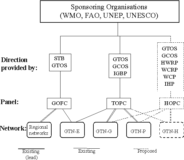
7.5 Initial Implementation
To advance the implementation of systematic global hydrological observation, the following activities are proposed by the participants:
Establish a Hydrological Observation Panel for Climate (HOPC, section 7.4), with the mandate to guide the development and implementation of systematic long-term global observations on behalf of, and in collaboration with the sponsoring programs/agencies. HOPC should also be the lead panel guiding the work of GTN-H, in consultation with other panels
Obtain endorsements and co-sponsorship for HOPC
Establish GTN-H as outlined in this report and based on further elaboration of more detailed plans by HOPC
Obtain endorsement for GTN-H from the proposed sponsors and participants; obtain agreements to participate and contribute resources by the existing observing networks, data and product centres, and other important contributors
Identify major present barriers to more effective use of existing data and products, and implement remedial measures
In consultation with clients define data products, milestones, and work plan (see initial version in section 7.6). This should include a useful new product within 2-3 years that will demonstrate the effectiveness of GTN-H
Implement the plan.
In developing GTN-H the design of the metadata base as well as database implementation, operation and maintenance should be components of the strategic plan. A metadata base will also be required to handle information about the data that will be used to assist in interpretation and analysis.
7.6 Proposed Products
Table 2 describes potential GTN-H products that were identified by meeting participants as important to a variety of clients, with several being feasible within the initial GTN-H period.
Table 2. Proposed GTN-H Products for the Initial Period
|
Product name |
Content |
Use |
Spatial resolution |
Temporal resolution |
Time- liness |
Contact |
|
Discharge |
gridded runoff fields |
Water balance computations |
1o x 1o |
Monthly (ongoing) |
DT (delayed time) |
GRDC (W. Fröhlich) |
|
Discharge |
Point data |
Weather forecasting (model validation) |
N/A |
Daily (ongoing) |
NRT (near-real time) |
GRDC (W. Fröhlich) |
|
Soil moisture |
Gridded (preferably) |
Weather forecasting (assimilation in models) |
TBD |
Daily (ongoing) |
NRT |
CEOP (J. Leese) |
|
Discharge |
Regional totals |
Global water cycle analysis |
by region |
Monthly |
DT |
GRDC (W. Fröhlich) |
|
Discharge |
Point data |
Regional water cycle analysis |
For CEOP regions |
Daily and monthly > (CEOP period) |
DT |
GRDC (W. Fröhlich) |
|
BGC flux into oceans |
By major watershed |
Global BGC cycles analysis |
By watershed |
Daily to monthly (ongoing) |
DT |
GEMS Water (A. Fraser) |
|
Isotope composition |
d18O, d2H, 3H |
Various |
By station |
Weekly to monthly (ongoing) |
DT |
IAEA (M. Gröning) |
|
Hydrographic separation |
Discharge as % of inputs |
Regional water cycle analysis |
By watershed |
Weekly to monthly (ongoing) |
DT |
IAEA (M. Gröning) |
|
Isotope composition |
d18O, d2H |
Global BGC cycles analysis |
By station |
Weekly to monthly (ongoing) |
DT |
IAEA (M. Gröning) |
|
Hydrographic separation |
Discharge as % of inputs |
Global BGC cycles analysis |
By watershed |
Weekly to monthly (ongoing) |
DT |
IAEA (M. Gröning) |
|
Precipitation |
Solid and liquid |
Regional water cycle analysis |
For CEOP regions |
Daily (CEOP period) |
DT |
GPCC (B. Rudolf) |
|
Precipitation |
Solid and liquid separately |
Regional water cycle analysis |
1dx1d globally; 0.5o x 0.5o regionally |
Daily and monthly (global ongoing, regional for limited periods) |
DT |
GPCC (B. Rudolf) |
|
Snow water equivalent |
Gridded |
Various |
TBD |
TBD |
DT |
NOAA |
|
Ground water fluxes |
Aquifer withdrawal rates |
Various |
By aquifer |
TBD |
DT |
TBD |
|
Water use |
Differentiated consumptive use |
Various |
Point or polygon |
Monthly, ongoing |
DT |
GRDC (W. Fröhlich) University of Kassel, P. Döll |
|
Water use |
Gridded consumptive use |
Various |
0.5o x 0.5o |
Monthly |
DT |
University of Kassel, P. Döll |
|
Surface storage Flux |
Volume changes in lakes and reservoirs |
Water cycle analysis |
Polygon |
Monthly or seasonal (ongoing) |
DT |
TBD |
|
Precipitation, evapotrans-piration, Other |
Point data |
Real time data for assimilation in models |
Point |
Daily |
RT |
TBD |
7.7 Resources Required and Available
As a basis of the day-to-day operation of GTN-H, the participants felt that the collaborating institutions and data centres should cover operating expenses from their existing budgets. However, additional resources will be required to fund co-ordination activities of GTH-N and to assist partners who may have not sufficient resources to participate fully in the GTN-H activities. This is especially important in developing countries whose collaboration must be sought.
The following incremental cost items were identified:
Organisation and conduct of meetings including those HOPC and travel involved in these activities
Development and maintenance of a Web-site for GTN-H
Publications
Network design and implementation
Short-term consultants and science contracts in particular for product generation.
Sources of funding were discussed in detail and the group agreed on the following list of sources for potential funding extra-budgetary activities of GTN-H:
Contributions in kind from core funding institutions (mainly those who fund day-to-day operations of network participants and data centres)
Services (in the form of products) to funding organisations at national and international levels
General and specialised product generation on a non-profit base i.e. for development banks or regional economic commissions
Funding organisations such as the European Union through their R&D programmes
Private foundations
Funding UN-agencies such as UNDP, FAO and WHO in support of specialised projects/programmes of these agencies.
Taking into consideration operating guidelines of the existing centres, GTN-H is expected to operate within the framework of major resolutions of the constituent bodies of the sponsoring UN agencies, including Resolutions 25 and 40 of WMO which concern the exchange of hydrological information. To ensure sustainability of GTN-H, international funding for programme development and operations must be an integral part of the strategy. Without financial commitment for resources at a level necessary for sustained activity by partner agencies, the GTN-H will not be successful. The participants agreed to investigate funding opportunities and encouraged collaborating centres and agencies to pro-actively seek additional funding to support GTN-H activities.
7.8 Potential Contributions
Workshop participants identified potential contributions to GTN-H that may be feasible from within existing resources. The delivery of these contributions needs to be confirmed through discussions with management of the network operators and agencies participating in GTN-H:
CEOP: ensure link to GEWEX; facilitate GTN-H participation in CEOP. The GEWEX Hydrometeorological Panel is planning a Co-ordinated Enhanced Observation Period (CEOP) with a data collection taken from July 2001 through September 2003. The plans for compiling hydrometeorological data from a number of reference sites distributed over the continental areas of the globe (in the framework of the GEWEX Continental Scale Experiments) could provide an opportunity for a GTN-H pilot project involving eight of the eleven variables by GTN-H users.
CESR: provide water use data product.
CRU: participate in the definition, evaluation and application of GTN-H products; serve as link to AOPC/GCOS and the Hadley Centre; generate and provide related climate data sets (temperature, cloudiness, vapour pressure,..) updated for recent periods, monthly, 0.5o x 0.5o.
GCOS: work with WMO departments to reach the goals and objectives of GTN-H; assist GTN-H to establish effective links with WCP-Water; actively pursue the development and endorsement of GTN-H; through WMO Secretary General and COP, obtain countries' support for and contributions to GTN-H activities; contribute to developing, and submit to COP, guidelines for countries' reports on the state of national observing systems; promote GTN-H and countries' contributions through regional GCOS workshops; promote the acceptance of, and work with TOPC, GTOS, HOPC and WCRP on a IGOS water theme;
GEMS/Water: prepare a plan for GEMS/Water contribution to GTN-H for consideration by UNEP; expansion of the network to world-wide, in consultation with other participating GTN-H networks; evaluation of existing inventory data for computing total fluxes with GRDC; obtain additional existing data from countries; participate in the definition of GTN-H products; establish WWW links with GTN-H partners;
GKSS: participate in the definition, evaluation and application of GTN-H products; serve as link to BALTEX and other regional users;
GPCC: provide gridded precipitation products (ongoing); respond to recommendations of users as far as possible (e.g., separate solid and liquid precipitation products); quality control, quality analysis and documentation for all products; participation in the definition and generation of new products within GTN-H;
GRDC: obtain and maintain overview of existing on-line discharge data sources; select and propose a subset of these to meet GTN-H needs, and update as appropriate; establish a metadata base for the above sources; in co-operation with UNH develop monthly gridded runoff field products (Table 2); if feasible given available data, generate water use products (Table 2);
GTOS/FAO: actively pursue the development and approval of GTN-H; co-ordinate GTN-H incorporation in GTOS; provide secretariat support to GTN-H; with GCOS support organisation of meetings; provide limited travel support to meetings; facilitate collaboration with appropriate FAO Divisions (including Food Security, Water); provide access to water use statistics, food security data bases, ; incorporate GTN-H in the TEMS database; contribute to GTN-H publicity via SD Dimensions (WWW publication), GTOS reports; facilitate co-ordination between TCO, GTN-H and other activities;
IAEA: maintain GNIP; maintain and increase the number of GNIP sites; establish hydrological isotope data base (ISOHIS) on hydrological projects (ground or surface water); if possible, establish a network of ~30 stations and make river discharge isotope measurements;
Kyoto University: participate in the definition, evaluation and application of GTN-H products; serve as a link to GAME and FRIEND-ASIA; facilitate access to hydrological data in Japan, including consultation with government agencies;
TOPC: provide input to the establishment of HOPC and GTN-H structure; participate in the definition, evaluation and application of GTN-H products; provide ongoing input to GTN-H activities on behalf of GCOS/GTOS needs and applications;
UNESCO: assistance through regional FRIEND-networks, subject to agreements between regional FRIEND groups and GTN-H; collaboration can be envisaged in the fields of research projects, users and eventually exchange of hydrological data; recognition of GTN-H within the IHP programme; potential use of GTN-H data and services in the evolving UN World Water Development Programme; liaison of HELP activities with activities of GTN-H, in particular with regard to climate and water related issues, socio-economic (water use, sustainable development) subjects and hydrological process research and studies;
UNH: participate in the definition, evaluation and application of GTN-H products; produce products in collaboration with other GTN-H participants; serve as a product algorithm development and product generation centre within the GTN-H framework, subject to data access arrangements; provide developed and tested algorithms to GTN-H and other participants for ongoing product generation;
USGS: participate in the definition, evaluation and application of GTN-H products; if requested, serve as a contact with relevant USGS observation and research programs, including the hydrological observations available through the WWW;
WMO (other than GCOS): participate in the design and setting up of GTN-H and provide continuing assistance, including links with national agencies through CHy and WMO management; contacting member countries to provide co-ordination of existing stations for large basins; place into geographic data base context with GRDC; facilitate effective collaboration with WHYCOS, including GTN-H access to WHYCOS observations; continue WMO support to GRDC, GPCC, and other centres as they develop; assist in developing linkages with WCRP, GEWEX CSEs, WCP-Water, International Strategy for Disaster Reduction (ISDR); promote GTN-H in the climate-hydrological community through articles in newsletters (CLIVAR, GEWEX, CEOS, others; promote data delivery to GTN-H with respect to GRDC, GPCC, and other data centres;; link with WCRP in general and GEWEX in particular to promote the establishment and use of GTN-H; support of activities of GTN-H within the World Climate Programme - Water (WCP-Water);in contact Member countries of WMO to provide information about existing Data Collection Platforms in large river basins (need some more information);.
7.9 Follow-up Actions
Based on the above discussions and the issues raised, participants identified a number of follow-up activities that are needed to pursue the development of the GTN-H. These include:
Establishing contacts with other groups and programs to build on existing capabilities and interests. This can be achieved through presentations at meetings, discussions with programs, endorsements by key steering committees, and the development of collaborative activities. A more detailed list is provided below.
Communication with national agencies that collect and archive hydrological data. WMO has established mechanisms for this purpose. In addition, GCOS regularly reports to COP through SBSTA on the status of observing systems and needed improvements, and provides an avenue for raising observation issues at the national level. It is important for GTN-H to clarify the range of requirements relative to national agencies, to ensure that the contacts are co-ordinated and result in rapid progress at the global level.
Co-operation with GEWEX/CEOP. CEOP will establish high-quality regional data sets for most of the hydrological variables by means of satellite and in situ data as well as model assimilation, in several well distributed areas around the globe. GTN-H should to explore ways of collaborating with CEOP to enhance to production of global data sets. Given the CEOP schedule (starting in 2002), this is an urgent task.
Inclusion of GTN-H sites and networks in the GTOS' TEMS.
Timely application of hydrological observations is a critical emerging requirement for weather and climate forecasting concerned with time periods of 2-3 days or longer (section 3.). This has strong implication both for the observations themselves (number of sites and type of measurements) and for data transmission to the user agencies. For meteorological observations, GTS has been set up many years ago, and its operation is carefully managed by WMO and by national meteorological agencies. Addition of hydrological data presents a new requirement, and its incorporation into GTS will demand focused effort. GTN-H should explore this issue as a matter of priority and should, by involving the weather and climate forecasting as well as other relevant communities, initiate a process that will lead to the incorporation of hydrological data on GTS.
There is an opportunity to improve timely access to hydrological data through the World Wide Web. This is already being done by some hydrological agencies around the world, and vigorous action in this direction is needed. The web may also be a temporary solution for making real time or near real time data available for critical applications, e.g. numerical weather and climate assimilation and prediction models, pending more permanent solution through GTS.
The web should be used in the establishment of GTN-H as a network of networks. An early action should be the construction of a GTN-H home page with linkages to a) participating networks, b) relevant data sets, c) related programs, d) information systems and data bases (GOSIC, INFOTERRA, INFOCLIMA, INFOHYDRO).
The establishment of GTN-H and HOPC should be presented to various groups concerned with hydrology issues, and appropriate feedback should be obtained. There are a variety of forums for this step, including:
Steering Committees of GCOS (meeting 2000/09), GTOS SC
ICSU Environmental Advisory Committee
WMO Regional Association II session (2000/09)
WMO CHy (2000/11)
WMO Executive Council (2001/06)
WCP-Water (2000/fall)
SBSTA (2001/06)
UN Advisory Co-ordination Committee, Sub-Committee/Water (ACC/Water; 2000/11)
GHP meeting (2000/09)
AGU conference (2000/fall) semi-annual meetings (December 2000 and Spring 2001)
AMS meeting (2001/spring)
IAHS conference (2001)
The following schedule was considered desirable: draft report in July, 2000; draft final early September; final report October, 2000; establishment of GTN-H by the end of 2000.
![]()
![]()
![]()