![]()
![]()
![]()
Version 1
|
PREAMBLE Recognizing the growing need for systematic observations of the Earth’s environment and the need for earth observation to serve the needs of humankind, an Integrated Global Observing Strategy Partnership (IGOS-P) was established jointly by the Committee on Earth Observation Satellites (CEOS) and various international organisations concerned with global or regional environmental issues. Besides CEOS which represents national space agencies, IGOS-P membership includes the Global Observing Systems for atmosphere, oceans and land (G3OS); international research organisations (WCRP, IGBP); UN environmental agencies such as UNEP, WMO, FAO; and other agencies with interest in earth science and observations. To undertake the evolution of sustained global earth observations in a systematic manner, IGOS-P proposed the concept of observation ‘themes’, with the expectation that a relatively small number of themes can be defined which would serve as a framework for developing capabilities which integrate space and in situ observing. In June, 1999 IGOS-P agreed that it would be appropriate to define a theme on the terrestrial carbon cycle, and the Global Terrestrial Observing System (GTOS) agreed to lead its initial development in collaboration with the Canadian Space Agency. This prospectus is an initial outline of a theme dealing with terrestrial carbon. Its foundation is a recognition that the observation of the terrestrial component of the global carbon cycle is important in its own right, in addition to being a part of the global carbon cycle. It is anticipated that linkages with the ocean and atmospheric components (beyond those identified here) will be developed as part of the planning process. It is envisioned that, in responding to this theme, the IGOS partners will also establish new capabilities for the acquisition, processing, and distribution of earth-observation data which will enable other applications, e.g. improved natural resource management and highlighting areas of rapid land cover change. The TCI concept described here was initially developed during the fifth meeting of the Terrestrial Observation Panel for Climate (TOPC), a joint panel of the Global Climate Observing System (GCOS) and GTOS, on 27-30 July 1999 in Birmingham, the United Kingdom. TOPC mandate includes ensuring effective implementation of global terrestrial observation requirements for climate-related purposes. |
PART I: EXECUTIVE SUMMARY
The Global Terrestrial Carbon Cycle Initiative (TCI) is a coordinated international response to the requirement by the policy and scientific communities for improved knowledge of the role of the terrestrial carbon sources and sinks in the global carbon cycle and global warming. The new and unique contribution of TCI is information on the spatial and temporal distribution of carbon sources and sinks in the terrestrial biosphere.
Vision
TCI is envisioned as a functioning, continuously evolving network of frequent observations and computer models, targeted for documenting and understanding the present state of the terrestrial component of the global carbon cycle and for supporting policy formation at the national and inter-governmental levels. The input data will be provided by an optimised combination of remotely sensed and ground-based observing systems. The carbon cycling models must be sensitive to natural and human - induced changes in the environment; operate at a relatively high resolution to make optimum use of remote and in situ observations; and produce maps of terrestrial carbon sources and sinks (synonymously termed ‘C balance’ below) on a seasonal, annual, interannual, and decadal basis. The resulting products must be sufficiently detailed to be useful for international conventions, policy decisions, and climate or environmental change assessments at global, regional and national levels. Building on the synergy of integrated observing systems, additional products of value for the management of terrestrial resources will be added in due course.
Need
An accurate knowledge of the terrestrial component of the global carbon cycle has become policy imperative for this and the forthcoming decades, both globally and for individual countries. The underpinning reason is recognition that the increasing atmospheric CO2 concentration is an important causative factor for climate variability and change. This recognition led to fundamental policy decisions. For example, the Kyoto Protocol recognizes the role of terrestrial systems as carbon sinks and sources, and it provides a basis for developing future emission trading arrangements that involve forests and potentially other ecosystems. Although the specific information and reporting requirements are to be worked out, they are expected to include information on carbon sinks and sources at the national or sub-national levels. While such information is likely to be provided through various methods, there will be a need for a globally consistent source to serve as a reference and a basis for comparison. This is due to at least two factors: the need for compatibility among individual (national or project-based) reports, and the fact that all known methods contain uncertainties which can, however, be reduced by independent estimation methodologies. In addition to the reporting required by the Kyoto Protocol, the United Nations Framework Convention on Climate Change (UNFCCC) instituted inventories of the national greenhouse gas situation, including terrestrial sources and sinks.
The above policy steps were taken in spite of an incomplete understanding of the pathways through which the anthropogenic CO2 leaves the atmosphere, thus negating a portion of the human-caused emissions. For example, about 15-30 percent of the anthropogenic carbon emissions cannot presently be accounted for, and are presumed to be absorbed by terrestrial ecosystems in the Northern hemisphere. A more accurate knowledge of the sequestration of the carbon emissions is therefore critical to the effectiveness of the carbon - related policies. Of equal importance is the ability to predict the future evolution of the atmospheric CO2 concentration in order to optimize mitigation policies and measures. The amount of carbon uptake and release by terrestrial ecosystems is a major uncertainty in these regards, and its better knowledge is essential to making progress in dealing with the climate change issue. In addition to the environmental policy dimension, the distribution and quantification of biospheric carbon has important economic and resource management dimensions. In particular, the yield of forest, rangeland and agricultural resources is a strong function of carbon tied up in the above-ground biomass. It is expected that improved understanding of the terrestrial carbon cycle can provide insight for improved management of forest, rangeland, and agricultural resources.
There is no present capability to estimate the size of the terrestrial carbon sources and sinks frequently and over larger areas. Its importance was recognised in the early IPCC discussions but neither the techniques nor institutional arrangements were available. However, the rapid progress over the last 10 years in the methods for measuring and computing the pools and fluxes of terrestrial carbon makes it possible to propose a major new initiative in this area. In technical terms, the above information gaps translate primarily into the need to obtain the spatial distribution of net primary productivity (NPP) and net ecosystem productivity (NEP), both measured as mass of carbon per unit area per year. NPP is the carbon assimilated by vegetation through photosynthesis, minus the carbon lost because of respiration (i.e. ‘breathing’) by the living plant tissue. NEP is the difference between NPP and the loss through a decay of organic matter (above or below ground). In addition, fire and other disturbances, and land use (e.g. cropping, grazing and silviculture) are important in determining long-term carbon retention by ecosystems, i.e. their net biome productivity (NBP). Therefore, determining the spatial and temporal characteristics of NPP, NEP and NBP are priority issues for TCI.
Goals and scope
The scientific and organizational problems posed by the TCI vision are significant, very challenging yet solvable. They cannot realistically be achieved in one step over a few years. Instead, a phased approach based on a combination of research and operational activities is the most effective strategy. Thus, for the near future the following goals are identified:
By 2004, demonstrate the capability to map the global spatial distribution of the sources and sinks of the terrestrial biospheric carbon with a TBD (to be determined) accuracy for areas as small as TBD (e.g. ±30% over areas ³4km2), and generate the global and regional map products.
Starting in 2008, produce an annual digital database of the terrestrial carbon sources and sinks on an ongoing basis, with the above or better accuracies.
The scope of TCI is characterized by emphasis on the current (at the time of observation) spatial distribution of the sources and sinks in terrestrial and aquatic components of the biosphere; long-term, global observation; and products for seasonal, annual, interannual, and decadal periods. TCI thus encompasses the terrestrial and associated atmospheric parts of the carbon cycle. These bounds are motivated by the need to fill a gap and to maintain a focus so that the effort may be productive. Consequently, TCI must be linked to activities concerned with the oceanic component of the global carbon cycle, and with programmes addressing C-related issues in the socioeconomic sphere.
Benefits
Results of TCI will provide immeasurable benefits to many constituencies and at many levels, from global to national. Why? First, the knowledge of carbon sinks and sources is very important, as briefly discussed above and as evident from the wide attention given to this problem by the policy, international, scientific and business communities worldwide. Second, there is no feasible way for a single group or nation to obtain such information reliably and cost-effectively because of the complexity of the environmental processes involving CO2 (which occur at many interconnected levels, from landscape to globe) and because of the need to obtain a range of measurements (both in area and in time). However, a combined effort that brings together organisations with space and ground-based observing capabilities, users, and the scientific community does make the problem tractable and offers a high probability of success. Decreasing the build-up of greenhouse gasses in the earth’s atmosphere will require unprecedented international cooperation. This initiative will bring about substantial international cooperation in an important area of that effort, i.e. improved information upon which difficult decisions can be based. Its contribution includes, but is not limited to, the provision of complementary and globally consistent information for the Kyoto Protocol.
The way forward
To be successful, TCI must involve the participation of agencies and groups that would benefit from the outputs TCI aims to produce, and whose programmatic interests are compatible with the TCI vision. The steps listed below are intended to obtain initial consensus on TCI and to facilitate the involvement of the various communities:
Solicit feedback on the TCI concept by distributing this prospectus in the scientific, observation (satellite, ground-based), and user (international, national, policy, business?) communities.
Obtain consensus on TCI aims and framework.
Analyze in detail the technical aspects of the observation, data processing, modelling and quality control, primarily through discussions in the scientific and observation communities.
Develop a phased implementation plan, building on current pilot projects (Global Observation of Forest Cover, GTOS Net Primary and Ecosystem Productivity); national programmes and planned activities; international research projects; space agency mission plans; and other related activities.
Identify agencies, research programmes and other groups interested in participating in TCI; develop suitable mechanisms; and obtain commitments for participation.
Identify near-term and mid-term gaps that remain to be addressed to make TCI successful, and develop appropriate response by involving additional participants or by initiating new activities with additional resources.
Develop a transition strategy to a long-term operation.
Begin implementation.
PART II: TECHNICAL BACKGROUND
1. Principles of observation
In the terrestrial environment, carbon is present in three main pools: atmosphere, plants and soil. NPP and NEP express the net fluxes between these pools. In theory, it is conceivable to measure the sizes of the pools and to compute NPP and NEP for a parcel of an ecosystem from the changes in these. However, this is not feasible by traditional methods, first because these methods employ destructive sampling (cutting plants, digging soil pits), and secondly because they are very costly and cannot be applied over large areas. It is thus not surprising that actual NPP and NEP measurements obtained so far are extremely scarce. In recent years, practical alternatives have emerged which employ non-destructive measurement procedures, coupled with models that mimic the behaviour of carbon within the ecosystem or in the near-surface atmosphere. Such measurements are typically carried out from towers (to measure CO2 fluxes or concentrations) or from satellites (to quantify the spatial patterns of ecosystem characteristics that control CO2 exchange). While these measurement strategies also require some destructive sampling, its extent is limited to ensuring that the models perform satisfactorily. Great progress has been made in our understanding of the biospheric components of the carbon cycle, the construction of models of carbon-related processes within the ecosystem, and the ability to combine data from various sources to obtain quantitative estimates of carbon exchanges over specific areas and periods of time.
2. State-of-the-art
Fundamental advances have been made in the use of atmospheric CO2 measurements to define the size and the continental or regional distribution of biospheric sinks, using global atmospheric tracer models. Large experiments have been carried out in selected ecosystems (boreal, tropical, temperate) that have greatly advanced our ability to model carbon fluxes as well as to establish and improve the accuracy of products derived from remotely sensed data. Satellite data and derived products such as land cover, leaf area index, and burned biomass have been generated that allow application of ecosystem-specific carbon exchange models. A 15-year data series has been assembled and products generated for specific regions (tropical forests, boreal ecosystems) or the globe (e.g., land cover, biomass burning). Ground-based networks have been established that measure carbon fluxes between the ecosystem and the atmosphere on time scales of minutes to years, thus providing data essential to testing computer models and for validating the accuracy of the final products. Several flux networks have been established (in North America, Europe, Asia, Australia) and operated for various periods of time. The necessary supporting data sets (e.g., soil parameters) have been assembled for various regions and in some cases for the global landmass. Detailed (1 km2 cells) spatial distributions of the annual carbon uptake by vegetation have been successfully mapped at the regional level, with techniques that can be applied globally. The main remaining issues regarding carbon cycle quantification have been identified, and corresponding research plans have been developed and translated into new international or national research initiatives (e.g., in the United States carbon cycle science plan). In addition, new satellite missions are under way that will yield products with a greatly improved sensitivity to terrestrial carbon dynamics, enabling scientists to quantify the distribution of sources and sinks more accurately.
So far, the above various activities have taken place over limited areas, at different times and for different reasons, as part of research agendas. However, given the progress achieved and the imperative for better knowledge of the terrestrial carbon cycle, it is now feasible to consider an integrated system which takes advantage of these developments to establish an initial observation strategy for the globe.
3. TCI framework
3.1 Overall description
Given the diversity of CO2-ecosystem interactions in the global biosphere and the measurement uncertainties in any single observation strategy, a two-prong observation strategy is necessary which consists of ‘top-down’ and ‘bottom-up’ elements. Since atmospheric CO2 concentrations can be determined accurately and the global distribution computed from relatively few measurements, the regional distribution of terrestrial sources and sinks can be effectively constrained ‘top down’, using these measurements and associated atmospheric circulation models. However, this approach alone does not provide sufficient information on the spatial distribution of CO2 balance at the regional or landscape levels. In addition, the top-down approach does not elucidate the underlying mechanisms responsible for carbon balance distribution. Thus, it cannot be used to predict future carbon balance distribution and thereby assist in forming C-related policies and management options. Consequently, a complementary ‘bottom-up’ approach is necessary in which the carbon balance is assessed individually for small parcels of the terrestrial ecosystems, the size of which is determined primarily by the resolving capabilities of the satellite sensors. The results of these assessments are then combined to ensure both global/regional consistency and geographic specificity.
3.2 Functional components and flow
Because of the great variability of the terrestrial biosphere and the sensitivity of biospheric processes to the atmospheric conditions, the realisation of the TCI vision requires an integrated approach based on several components (Figure 1,2):
Frequent and sustained satellite observations with various sensors
Previously, these observations have most often employed data from the United States. NOAA series of satellites. Approved and planned satellite launches by the United States, Japan, the European Space Agency and other CEOS members will provide significantly enhanced capabilities over the next several years. Beyond these, the continuity of observations as well as the feasibility of additional important measurements needs to be examined.
Ongoing ground-based measurements at locations selected across the range of biomes and climatic conditions
Three main types of networks have been devised for such measurements. First, periodic air sampling of CO2 at the surface and its precise analysis is conducted by a CO2 flask sampling network to provide the basis for continental/regional level analysis. Second, an initial network of tall towers has been built to measure CO2 concentrations at higher altitudes (typically 100-500 m) as a basis for estimating the continental or regional distribution of CO2 sources and sinks. Third, several regional networks of short towers (typically twice the height of the vegetation canopy) have been established to measure CO2 exchange for various local ecosystem conditions, and to validate models of canopy-CO2 interaction as well as models estimating the spatial distribution of CO2 sources and sinks. The representativeness, comprehensiveness, and continuity of these networks are issues requiring attention.
Reliable procedures for translating the remotely sensed and ground-based measurements into environmental variables
For satellite data, these include corrections for atmospheric and other effects that distort the relationship between the variable of interest and the measured signal, followed by algorithms that transform the corrected signal into an ecosystem variable. For ground-based measurements, corrections are similarly required to account for the deficiencies of the measurement techniques and to translate the measurements into units of CO2 exchange.
Quantitative models of the processes of carbon exchanges within ecosystems, within the atmosphere, and between ecosystems and the atmosphere
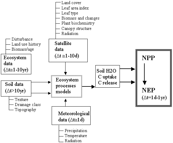
Two basic classes of models have been successfully developed. Atmospheric inversion models describe the dynamic behaviour of the atmosphere and the transport and mixing of CO2 within it. On the other hand, ecosystem models mimic the processes that influence CO2 uptake and release and their dependence on the atmospheric and local ecosystem conditions, typically on a daily basis.
Systems/organisations engaged in the acquisition, processing, output generation and quality control through which the resulting products will be generated and made available
So far, these have been carried out as research activities in various countries or international programmes.
4. Issues
To realize the above vision, a detailed plan needs to be developed. Such plan must consider a number of issues, including those briefly discussed below.
4.1 Readiness
The TCI concept is based on scientific and technical accomplishments in several different areas: ground-based and satellite instrumentation and measurement techniques; atmospheric and ecosystem modelling, including a much improved understanding of the processes involving CO2; and the conduct of coordinated research campaigns, allowing to test components of the entire system. These achievements, the anticipated quantum improvements in satellite observing capabilities in the next few years, and the importance of the global carbon cycle provide ideal setting for TCI at the present time. However, successful implementation must take into account a number of issues, including those listed below.
4.2 Comprehensiveness of observations
At the present time, neither the present ground-based nor remotely sensed observing capabilities are sufficient to produce long-term, globally consistent observation of terrestrial carbon sinks and sources. The main challenges in the ground-based networks are representativeness, continuity, and cost. The geographic distribution is based mostly on previous research priorities and interests, without adequately considering the need for global coverage. The networks are operated as part of research programmes, typically of a limited duration, and no adequate provisions have been made for a long-term operation. Also, the equipment and measurements are relatively costly, although the unit costs have been decreasing rapidly due to technological development.
In the satellite domain, the quality and continuity of observations are of major concern. Satellite data used so far were not originally intended for this purpose, thus they are marginally suitable. In the near future, greatly enhanced capabilities will become available through several missions. However, the long-term continuity of measurements has not so far been assured. Furthermore, additional measurements are required which necessitate the development of new sensing technology (e.g., vegetation biomass, leaf biochemistry, canopy horizontal and vertical structure). The needs for high-spectral resolution (for leaf biochemistry) and multiple angle (for canopy structure) satellite sensors have not yet been adequately addressed for global applications. These issues can be resolved but they will require close attention within the IGOS-P framework as part of the TCI preparations.
4.3 Data analysis and modelling
The capabilities of atmospheric and ecosystem models for estimating the spatial distribution of CO2 sources and sinks have been clearly demonstrated in numerous studies. Nevertheless, significant further research and demonstration are needed to ensure long-term success of TCI. The challenges include: developing a closer synergy between top-down and bottom-up approaches; further validation of CO2 exchange models in various regions and ecosystems, both natural and managed; further improvements in and the validation of algorithms for transforming raw measurements (satellite or ground-based) into biophysical parameters; preparation of key, high quality ancillary data sets such as land use history and terrain elevation; and the establishment of quality control procedures to ensure the ongoing quality of TCI outputs in an operational setting.
4.4 Implementation process
In view of the large spatial variability of terrestrial carbon distribution, the policy and economic interest in the terrestrial biosphere and the need for ground data from various regions of the world, the basic mechanism for TCI implementation must be collaboration of countries and institutions in a mutually beneficial manner. The implementation framework must therefore facilitate the contributions of various participants as providers (of data, supporting financial resources, scientific expertise) or as users (of the data, output products, or results of analyses). In the near future, TCI can be most rapidly advanced if undertaken as a research and demonstration programme, supported by an ongoing acquisition and processing of satellite data. This is because of the relative complexity of the process leading to CO2 balance estimation as well as the present state of methodological development. It is important, however, that both users and agencies involved in data collection and processing be closely involved throughout, thus ensuring both the effectiveness of the TCI outputs and the viability of a long-term operation.
A number of activities are presently under way that are relevant to TCI. These include:
Data collection and processing using satellites presently in orbit (e.g., NOAA, Landsat, SPOT, GOES/METEOSAT).
Construction and planned launches of new missions, both research and operational (e.g., EOS, ADEOS, ENVISAT, EarthProbe, VCL, NPOESS).
Global Observation of Forest Cover (GOFC), a pilot project of IGOS-P which aims to provide a significant part of the information required by the TCI bottom-up approach and the GTOS Net Primary and Ecosystem Productivity Project.
International research programmes focusing on carbon cycle questions (e.g., IGBP).
Regional programmes aimed at terrestrial carbon assessment (e.g., the European initiative Global Monitoring for Environmental Security).
Regional research campaigns (e.g., the LBA Study).
National carbon cycle research or observation programmes (e.g., Canada, the United States).
Others.
All above-mentioned activities are potential contributors to some aspect of TCI. A significant near-term challenge is therefore to encourage closer coordination of these efforts in order to minimize potential duplication of effort but more importantly, to harmonize these activities and identify gaps that need to be addressed through additional projects where necessary. The most important task is to identify actions that are necessary to obtain an initial version of the TCI, and to implement these.
Figure 1
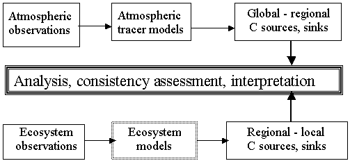
Figure 2a
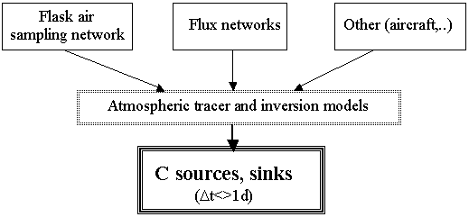
Figure 2b
![]()
![]()
![]()