


This study made use of the data flow diagram (DFD) approach following the three
most important components of data and information management for the environment
and natural resources (ENR) – processes, files and flow (see Figure 1). Processes
show what systems do. Each process has one or more data inputs and produces
one or more outputs. Each process has a unique name and number (Hawryszkiewycz
1994). On the other hand, a file is a repository and contains data that are
retained in the system. It refers to a data store and each file contains important
data that are transported accordingly between processes and external entities.
“Flows” model the passage of data in the system between processes, between
a data store and a process, from a source to a sink, or from a process to
a sink.
Processes reside within the system boundaries. Those that are outside its boundaries,
but are important to the functioning of the system, are called external entities.
These are usually beyond the control of the system but are referred to as
either sources or sinks. Sources are external entities that supply data to
the system while sinks are those that use the data. Processes and files are
visualized using a DFD. A DFD shows how data flow within a system.
DFDs may be established at different levels of an organization; depending on
the requirements of the task, more details can be added to the diagram. For
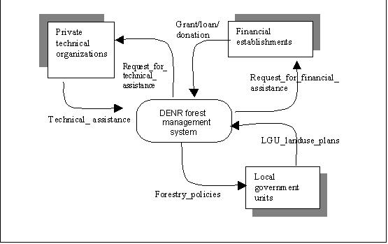
example, a contextual DFD may appear as shown in Figure 1. As mentioned earlier,
DFDs may be drawn in more detail depending on the requirements of the analysis.
Figure 2 shows that an Integrated Forest Management Agreement (IFMA) system
may be sub-divided further into its component sub-systems. These components
may refer to the following processes: species-site identification, ground
validation, IFMA preparation and proposal, monitoring and evaluation. The
input and output files are shown by the corresponding arrows which also indicate
the flow of data.
Figure 1. Contextualized DFD for a DENR Forest Management System (after FMB 1998)
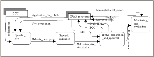
Figure 2. DFD for an IFMA system (after FMB 1998)
A combination of primary and secondary data was used in the analysis. Primary data were gathered using an interview schedule that had the following components (see Appendix 1 – Survey Guide Questionnaire ):
Interviews were conducted with officials concerned at the different levels of the organization. Those interviewed at the study sites had a wide range of responsibilities and positions – especially the community, provincial and regional ENR officers; they included planning officers and staff from different units such as the timber management unit, the forest protection unit, the reforestation unit, community-based forest management (CBFM), and the protected areas and wildlife service (PAWS) unit. Planning officers at the different offices, including the central office, were also interviewed. A list of those interviewed and their assignments and positions is given in Appendix 2 .
Initial results from field visits and interviews were analyzed at a three-day workshop attended by representatives from six regions and the central office (see Appendix 2). The number of workshop participants was restricted to maximize discussions and interaction. The participants represented various levels of the decision-making hierarchy – regional, provincial and community ENR officers, and planning officers, including the director of the Forest Management Bureau (FMB).
The workshop was designed to elicit current practices in terms of data gathering and reporting procedures. The workshop was divided into three modules representing processes, files and flow. For each module, guiding questions were distributed and a plenary session was conducted for presentations. Some of the guiding issues or questions that were tackled during the workshop are listed below.
This referred to the DENR policy and implementing rules and regulations on forest and natural resources. Guidin g questions included:
This referred to data and information being surveyed/collected/monitored. Some of the guiding questions included:
This referred to the direction of files along the processes concerned. Some guiding questions were:
The DENR divides the
country administratively into 16 regions consistent with the political sub-divisions
of the country. Each region is further sub-divided into districts, provinces,
municipalities, barangays (villages) and sitios (hamlets).
Two regions namely Cagayan Valley and Caraga were chosen as sample sites.
The primary considerations in the choice of the study sites were relative
abundance of forest cover, socio-economic setting and accessibility.
The first study site is located in the northern part of the country while
the second is in the south. Both sites are accessible by land and air. Table
2 shows the forest cover for all regions of the country based on estimates
from SPOT imageries by the National Mapping and Resources Information Authority
(NAMRIA). On a regional basis, Caraga Region ranks first in terms of forest
cover followed by Cagayan Valley.
Table 2. Comparative analysis of forest
cover by region
|
Region |
Land area (ha) |
Forest cover (ha) |
Forest cover (%) |
|
Caraga |
1 850 177
|
936 152 |
50.60 |
|
Cagayan Valley |
2 621 887 |
1 036 437 |
39.53 |
|
CAR1 |
1 801 885 |
607 286 |
33.70 |
|
Southern Tagalog |
4 716 317 |
1 304 469 |
27.66 |
|
Southern Mindanao |
2 626 508 |
703 515 |
26.79 |
|
Eastern Visayas |
2 084 169 |
519 554 |
24.93 |
|
Northern Mindanao |
1 440 875 |
335 752 |
23.30 |
|
Central Mindanao |
1 395 102 |
307 983 |
22.08 |
|
Western Mindanao |
1 565 659 |
289 532 |
18.49 |
|
ARMM2 |
1 110 356 |
210 680 |
18.97 |
|
Central Luzon |
1 802 234 |
291 626 |
16.18 |
|
Bicol Region |
1 468 362 |
106 164 |
7.23 |
|
Western Visayas |
1 988 225 |
144 232 |
7.25 |
|
Ilocos Region |
1 276 504 |
68 804 |
5.39 |
|
NCR3 |
58 650 |
2 101 |
3.58 |
|
Central Visayas |
1 419 060 |
34 467 |
2.43 |
1Cordillera
Administrative Region
2Autonomous
Region of Muslim Mindanao
3National Capital Region
The determination of candidate study sites (or data collection points) was also
based on socio-economic parameters such as household size and number, growth
rate and population density (Table 3).
Table 3. Total population, number of households, average household size,
population growth rate and population density by region as of 1 May 2000
|
Region/province |
Total population1 |
Number of households |
Average household size |
Annual growth rate |
Population density |
||
|
1990–1995 |
1995–2000 |
1990–2000 |
|||||
|
NCR |
9 932 560 |
2 132 989 |
4.62 |
3.3 |
1.06 |
2.25 |
15 617 |
|
CAR |
1 365 220 |
263 816 |
5.15 |
1.71 |
1.82 |
1.76 |
95 |
|
Cagayan Valley |
2 813 159 |
554 004 |
5.07 |
1.51 |
2.25 |
1.85 |
105 |
|
Caraga |
2 095 367 |
393 362 |
5.32 |
1.82 |
1.63 |
1.73 |
111 |
|
Eastern Visayas |
3 610 355 |
715 025 |
5.04 |
1.84 |
1.51 |
1.68 |
173 |
|
Central Mindanao |
2 598 210 |
501 915 |
5.16 |
2.83 |
2.08 |
2.48 |
179 |
|
Western Mindanao |
3 091 208 |
595 728 |
5.18 |
2.42 |
2.18 |
2.31 |
193 |
|
Northern Mindanao |
2 747 585 |
542 075 |
5.06 |
2.32 |
2.19 |
2.26 |
196 |
|
ARMM |
2 412 159 |
393 269 |
6.13 |
1.8 |
3.86 |
2.76 |
211 |
|
Southern Tagalog |
11 793 655 |
2 410 972 |
4.88 |
3.53 |
3.72 |
3.62 |
251 |
|
Southern Mindanao |
5 189 335 |
1 066 199 |
4.86 |
2.64 |
2.6 |
2.62 |
263 |
|
Bicol |
4 674 855 |
891 541 |
5.24 |
1.91 |
1.68 |
1.8 |
265 |
|
Western Visayas |
6 208 733 |
1 211 647 |
5.12 |
1.3 |
1.56 |
1.42 |
307 |
|
Ilocos |
4 200 478 |
831 549 |
5.05 |
1.3 |
2.15 |
1.69 |
327 |
|
Central Visayas |
5 701 064 |
1 129 317 |
5.03 |
1.65 |
2.79 |
2.18 |
381 |
|
Central Luzon |
8 030 945 |
1 632 047 |
4.91 |
2.12 |
3.2 |
2.62 |
441 |
|
Filipinos in Philippine
embassies |
2 851 |
|
|
|
|
|
|
|
Consulates and missions abroad |
|
|
|
|
|
|
|
1In 2000, the population
of disputed areas was reported in the next higher geographic level. For example,
the population of Barangay A claimed by both Municipality A and Municipality
B will be reflected in the province.
Source: National Statistics Office, Philippines (2000)
The study sites are found in the least dense regions of the country with populations
exceeding 2.8 million and 2 million in Cagayan Valley and Caraga, respectively.
The highest reported population is in Southern Tagalog and the lowest is in
the Cordilleras. The average population growth rate from 1990 to 2000 has
been steady at 1.73 percent for Caraga and 1.87 percent for Cagayan Valley.
Southern Tagalog is the fastest growing region with an average growth rate
of 3.62 percent for the same period.
In terms of regional accounts, the combined agriculture, fishery and forestry
sectors sustained growth of 3.7 percent in 2001 with the highest amounting
to Php35.3 million in Southern Tagalog and the lowest in the Cordillera Administrative
Region at Php3.5 million. Cagayan Valley and Caraga posted Php11.7 million
and Php5.1 million, respectively. The figures for the study sites were slightly
higher than the previous year (2000). The gross regional domestic product
for 2001 was 2.7 percent and 1.5 percent for Cagayan Valley and Caraga, respectively.
Interestingly, the highest was registered in Northern Mindanao at 5 percent
while the lowest was posted in Western Mindanao at 0.6 percent.
Forest cover was the primary consideration in choosing the study sites. The extent
of forested area indicates activities related to forestry. Caraga and Cagayan
Valley represent the last forest bastions in the Philippines including Southern
Tagalog. More recently, these regions have been identified as biodiversity
hotspots, both locally and internationally. They are considered vital corridors
for biodiversity conservation. The study sites belong to the least densely
populated regions of the country. With 26 percent of the population living
in the uplands, social forestry in these regions fares better relative to
other regions.
