


Each ENR office was studied in terms of activities
on data gathering, organizing, input and maintenance. The type, quality and
amount (including location and extent) of data collected were noted through
interviews with personnel. Data transfer and information flow from the CENRO
was evaluated as these are transmitted to the PENRO; from PENRO to the regional
office; from the regional office to the central office and vice versa.
Files refer to data and information that are gathered
and kept at the respective unit/office. Once these files are sent out in compliance
with a directive or following a procedure, they become reports. In other words,
reports are received and sent out and when they are archived they become files.
The data and information collected at the CENRO level are shown in Table 4.
Table 4. Data and information at the CENRO level
|
Data and information |
Reports |
|
Inventory of private tree plantations Survey of plantation status (including residual
inventory) Private geodetic survey Forestland grazing lease agreement (FLGLA)
data Price monitoring List of licensees/permittees List of reforestation projects List of people’s organization/ cooperative
partnerships |
Report on issuances of forestry tenurial instruments
(e.g. CBFM) Confiscation/disposition report Log production and disposition Lumber production/disposition Land report Reforestation report Forest production report Biodiversity monitoring system report ENR profile Sectoral monthly accomplishment report (quarterly,
semi-annual, annual) Annual report |
Data collected by CENROs differ from those of PENROs, which collate the data
gathered by the CENROs. Its main function is supervisory and it compiles the
reports/data/information from the different CENROs under it. Local information
is available only at the CENRO level.
The central office outlines the programs and activities of the CENROs. For instance,
if the CENRO plans to implement activities on maintenance (e.g. timber stand
improvement) but the central office intends to carry out roadside planting,
adjustments at the CENRO level need to be made specifically in relation to
human resources and logistics. That is, CENROs have to adjust their budget
because additional funds for roadside planting are not included in their annual
budget. In the study, CENROs reported problems in data consolidation. Sometimes
data are inadvertently excluded during consolidation.
Maps are also used as references. They are drawn by hand and to date no training on computerized mapmaking (i.e. CAD or GIS) has been conducted. Private tree plantation owners and timber license agreement holders are required to submit operational, logging and development maps. Maps are reproduced by blue printing or by requesting hard copies from an independent or non-government office. PENROs and CENROs may request hard copies of maps from the regional office. Maps are also used as supporting documents for complaints on illegal activities to be filed in court. The types of data collected and stored at the PENRO are listed in Table 5.
Table 5. Data and information at the PENRO level
|
Data and information |
Reports |
|
Data on land use (including maps) |
PENRO profile |
|
CBFM-ISF data Area coverage data, listings and maps on the
various projects/activities/ programs Operational plans Progress maps |
Consolidated monthly accomplishment report |
|
Statistical report (quarterly) |
|
|
Price monitoring reports (monthly) |
|
|
Confiscation and disposition report (monthly) Statistical profile, every year at the end
of June |
For data maintenance, some DENR field offices reconstitute/reconstruct maps
on tracing paper that bear the recording officer’s signature. They also catalogue
reports/records in filing cabinets and computers, if available. A list of
data and information held at the Regional Environment and Natural Resources
Office (RENRO) is provided in Table 6.
Table 6. Data and information at the RENRO level
|
Data and information |
Reports |
|
Data and information on forest management
activities such as location, source of lumber, volume, sales, lumber
dealer, forest charges, area of operations, timber management plan,
private tree plantation, minor forest products, special uses (e.g.
salt works, bathing establishments, road right of way, grazing) |
Quarterly/annual accomplishment
reports Production reports for SIFMA/IFMA Monthly production and disposition report
Annual concession report Monthly production and disposition report Site assessment report with maps for foreign-assisted
projects |
|
Data and information on forest protection
activities such as confiscated logs, fire, pests and diseases, cases
filed in court, deployment of forest guards |
Forest protection report |
|
Data and information on CBFM such as CBFM
areas, people’s organizations, resource inventory |
PENRO sectoral and annual reports |
|
Watershed management |
Watershed profiles |
|
Land evaluation party |
Survey reports |
|
Regular reports such as monthly accomplishments,
quarterly, semi-annual, annual reports Statistical reports such as ENR statistical
profile, quarterly/annual statistical profile and regional profile |
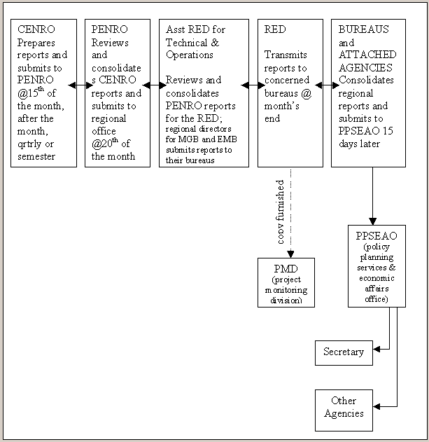
The DENR field offices prepare the following reports regularly: monthly accomplishments,
quarterly, semi-annual, and annual reports (see Figure 3). These reports are
prepared on the basis of the data and information that are gathered by the
respective ENR offices be they community, provincial or regional. Report submission
at the CENRO level occurs at the beginning of the month, the fifteenth of
the month, quarterly and by semester. At the PENRO level, CENRO reports are
reviewed and consolidated before they are submitted to the regional office
on the twentieth of the month. At the end of each month, the regional office
submits a consolidated report from all PENROs to the central office.
Reports are submitted via fax, courier, radio, telephone, and e-mail or by hand.
Reports are kept in the record section, if there is one. In retrieving files,
the record section officer is delegated as the property custodian, but as
the need arises, other employees also help. Logbooks are kept for receiving
and releasing communications and reports.
In the forestry sector, the community-based forest management information system
(CBFMIS) and forest stock monitoring system (FSMS) are used, although the
FSMS has not been implemented widely yet owing to a lack of computers. Even
if a computer is available, some staff are not familiar with the use of CBFMIS
and FSMS.
CENROs hold refresher courses and briefings or training for their staff. Training
is either hosted by the regional office, PENRO or CENRO. Staff are reoriented
on their regular functions and updated on other aspects of their duties. Staff
are also briefed on special projects. Through special orders, a forest ranger
can be transferred as a log scaler. In such situations, the CENRO implements
rescheduling and personnel adjustments to avoid total cessation of their regular
functions.
Field “truthing” and data discrepancy are also addressed. For example, the data
of a particular area submitted to the regional office describe it as forestland
but upon field validation the area is discovered to have been converted to
a kaingin (slash-and-burn) area. The regional office conducts field validation,
and if there are inconsistencies in the data, they return the information
to the field office for revalidation. In general, however, there is no standard
procedure for data collection, retrieval and overall management. A specific
figure, for example on plantation status, may appear in several reports, which
makes retrieval and updating a tedious process.
Within the context of the existing reporting system, there appear to be no gaps
because the reporting system is followed studiously. The problem, for instance,
in generating a forecast based on what has been reported, may not lie in the
contents of the report, but the data-generation instruments themselves.
In the Caraga Regional Office, a GIS database is available in ArcView®
format (e.g. shapefiles of municipal roads; national roads; provincial roads;
coastlines; rivers/creeks; regional boundaries; provincial boundaries; municipal
boundaries; lakes; provinces of Caraga; Caraga Region). Unfortunately, there
is no computer specialist for GIS databasing which makes the data vulnerable
to corruption and loss.
GIS data structures and analytical techniques are being incorporated gradually,
however. Although some GIS encoding is pursued through georeferencing of important
GPS points, its use is primarily for cartographic presentations. Despite its
availability, GIS use lacks analytical form mainly for the following reasons:
Usually, GIS processing is contracted out to GIS companies. Unfortunately, the
GIS service provided is limited by the requirements imposed by the client
organization – requirements that are essentially cartographic in nature. In
addition, the reports submitted are in paper form and do not permit further
analysis. Even if digital files are submitted, the maps are not in GIS format.
Occasionally the regional office requests a report/data/information
from the PENRO but the PENRO passes the retrieval of files to the CENRO, even
when the PENRO has its own copy. This problem arises because of the lack of
a standard data management system. A system has to be introduced that systematizes
data and information collection, retrieval, updating and reporting. Even on
a manual basis, if such a system is in place, files and reports can be accessed
easily and data duplication and waste of time can be avoided. The importance
of a computer-based system similar to CBFMIS or FSMS cannot be overemphasized.
Such a system that imposes protocols for data and information handling will
facilitate work for everyone. At the same time, the flow of information as
outlined in Figure 3 can run smoothly.
Figure 3. Forestry statistical reporting system (after Quintos 2002 )
The current practice for data and information handling makes it difficult to
monitor the important activities of the ENR offices. The implementing rules
and regulations (IRR) that are based on policies have to be improved, being
cognizant of the local situation. Different CENROs have different problems
and situations. There are policies applicable in one CENRO that are not applicable
in other CENROs. CENROs should set their goals and targets based on their
specific needs and circumstances.
There are questions related to the transport of wood products from narra (Pterocarpus
indicus Willd) produced by people’s organizations across provincial borders.
As a policy, however, logging of narra is strictly regulated. In effect, policies
should be reflective of the true condition of the forest and socio-economic
realities. Some policies should be reviewed and revised. Another example is
the documentation on the cutting and transport of logs. There are cases where
logs have been confiscated because the accompanying documents differ from
those belonging to the inspection team.
The most notable policies issued relate to: the statistical reporting system
(SRS); the revised price monitoring system (RPMS); the physical performance
monitoring system (also covers financial monitoring); and the land classification
monitoring system (LCMS), which subsequently was transformed into the forestry
statistics monitoring system (FSMS). In terms of forest cover assessment,
the FSMS can be very useful. At the moment, however, there is no policy on
national inventory although a proposal for one is underway. Assessment of
forest cover can also be derived from ongoing and completed special projects,
and reports of licensees, including CBFM project reports. Land cover statistics
for the country used data from the Philippine-German national forestry inventory
project in the 1980s. However, the projection formula has become invalid because
logging of old growth forest stopped after 1992. Since 1998, NAMRIA and other
stakeholders have tried to devise a new projection model. Care should be taken,
however, when new projection models cite increasing forest cover. Such results
should be backed up by data collected in the field.
Unfortunately, without a national policy on environment and natural resources
(ENR) inventory (at least on forest cover), estimates will not improve. A
policy for generating baseline data is lacking and there is no single policy
on ENR assessment. As a policy, all contractors should be required to submit maps in
GIS format, preferably ArcView or ArcInfo® – the system that is
widely available within the DENR.
