![]()
![]()
![]()
12/10/1990 – 6/11/1990.
By
J. IKWAPUT
BIOLOGIST/STATISTICIAN.
ABSTRACT |
| This report gives a brief of the Frame Survey conducted by the
Lake Victoria Entebbe team. It touches on some of the logistic
problems encountered by the team during the survey and describes
the observations made by the supervisor during field visits. |
December, 1990.
1. INTRODUCTION :
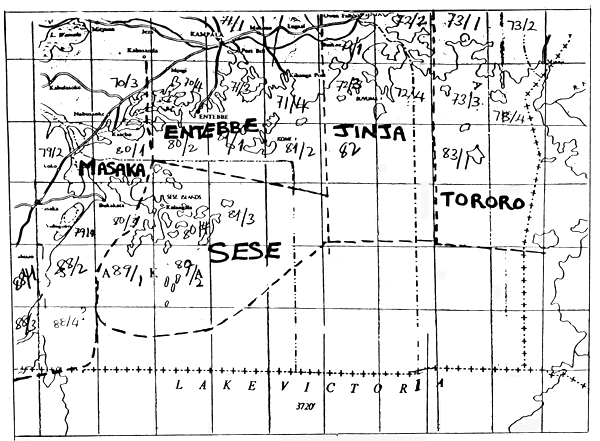
A frame survey on the fishing factors in Lake Victoria was organised by the Project UGA/87/007. Prior to the onset of the survey, a refresher course was conducted for the frame survey participants from the Lake Victoria Regions and the Masindi Region on Lake Albert.
Lake Victoria was divided into 5 regions, each to be covered by one team (see attached sketch map, ANNEX I). Each team was given maps of 1: 50,000 scale for the area they were to cover. Members were given instructions on how to fill the two questionnaires, Fraform . A1 and Fraform .A2. Fraform A1 is the general landing questionnaire, while Fraform A2 is a boat card where particulars on one individual boat is recorded.
Lake Victoria Entebbe Region had part of its administrative area given to Jinja Region for survey purposes since the area covered by the region is quite large. The area which was given to the Jinja team covered the Buvuma main island with all the small islands in Bwema county together with the mainland stretch running from Senyi Landing to Kiyindi Landing.
2. LAKE VICTORIA ENTEBBE FRAME SURVEY :
The Lake Victoria Entebbe Survey Team was composed of the RFO, Mr. S.S. Nkusi; 2 AFDO's, Mr. E. Sembalirwa and Mr. L. Sserunjoji. The team also hired the services of a coxswain from Gaba fish landing to guide them through some of the areas they were not familiar with, since both Mr. Nkusi and Mr. Sserunjoji were new in the region. The overall supervision of the team was assigned to Miss J. Ikwaput, Biologist/statistician from Project Headquarters.
The team received their supplies which consisted of 180 Litres of fuel, forms and others, (see APPENDIX 1) on the 11/10/90. The Regional Office had a wooden boat together with a 25 Hp engine which they had earlier obtained from the department. The team was asked to use this boat and engine for the survey since the project boats were not ready. The team set off for their first leg of the survey on 12/10/90 and was accompanied by the Headquarters supervisor for the first few landings for on the spot instructions on how to fill the forms. After surveying the first two landings along the Entebbe Botanical gardens shoreline, the engine started having mechanical problems. The team got some mechanical assistance from Kitubulu fish landing and was able to continue with the survey. The supervisor left the team at Kitubulu Landing. After 3 days of surveying, the team returned back to Entebbe pier after the engine had completely failed to operate. On Monday 15/10/1990, they were given the project engine Johnson 25 hp to replace the old one they had been using. They also took along the fibre glass boat (loaned to the Project by Mr. John White) which was lighter to operate as compared to the wooden one they had. The team resumed the frame survey and progressed well. They received further supplies of fuel of 160 litres on 17/10/90 and they used that fuel to cover the area between Kasenyi and Gaba fish landing. They also worked on some landings along the shore line towards Mukono. The team used Gaba as their base of residence during that period. However, they ran short of fuel and were given further supplies of 140 litres on 20/10/90. The supervisor now joined the team and worked with them from 21st - 23rd October, covering the landings along the shoreline from where the team had stopped upto Katosi landing and the Islands of Paradise and Soweto. A night was spent at Paradise Island. The supervisor dropped off at Katosi fish landing on 23rd and had to travel back to the Headquarters to get more supplies of fuel.
On 24th October, the team was given another 120 litres of fuel and they proceeded to Kome islands where they worked for 4 days. They returned back to Gaba landing on the the evening of 27th after seeing that their supplies of fuel were low. Mr. Nkusi reported to the Headquarters on Monday 28th and after holding discussions with the supervisor and the CTA, it was calculated that the team would require another two weeks to be able to complete the Kome group of islands, the area between Katosi fish landing and the meeting point with the Jinja team, and the islands of Lwaji, Kibibi, Kerenge, Kiwa, Bwema, Mpata, Bukwaya, Nyenda, Buziri, Waitwe, Wabuziba, and Marija. The supervisor was given funds for 360 litres of petrol and was asked to join the team for at least one week.
The team set off on 31/10/90 from Gaba fish landing for Kome Islands to complete the remaining part of the islands. The team worked there upto 2nd november and returned to the mainland at Katosi on the evening of 2nd. They continued along the shore line towards Kiyindi covering the landings of: Bukwaya, Bubanzi 1 and 2, crossed to Kisutu island, crossed back to the mainland and covered landings in Buwuka bay, Kibanga port, Bukwaya sub bay, Wera bay, crossed to Lwaji Islands and covered the landings on Lwaji Island before proceeding on to Ziru and Kerenge islands. After Kerenge island, the team proceeded to Kiyindi landing for consultation with the Jinja team on who should cover the small islands near Buvuma islands. This problem had arisen because the islands were situated on the map which was given to the Jinja team and yet Jinja team thought it was to be covered by the Entebbe team. After the two teams had met, the Entebbe team decided to return to Entebbe Pier and both the RFO of Jinja and RFO Entebbe reported to the Headquarters for consultations with the supervisors and the Acting CTA. After discussion with the Acting CTA and the NPD, it was agreed that the Jinja team covers the remaining islands and they were given more fuel supplies and more nights out. This marked the end of the frame survey by the Lake Victoria Entebbe Team.
3. CONDUCT OF THE SURVEY :
The whole survey was carried out using water approach as most landings are not accessible by land and besides not all landing points were known. The team travelled close to the shoreline and identified all the landing points using binoculars. Whenever a landing was identified, the team landed and located the landing on the 1 :50,000 scale maps they were given. After identifying the point on the map, it was marked with a pencil and map code number assigned to it. This map code number was filled on the Fraforms A1 and A2 so as to avoid confusing up landings later on during the processing of the frame survey data. After locating the landing point on the map, the team contacted one or more knowledgeable respondents who would answer all the questions on the forms. The team worked from early morning upto late evening. Usually, the team didn't have lunch and camped in the evening near a fish landing where they prepared their meals.
4. OBSERVATIONS :
The team members progressed well with the survey. Some difficulties were experienced with certain questions on fraform A1. However, after consulting the supervisor, they were able to fill in all the questions properly. Their main problem was with Fraform A2 (individual boat card). In most landings, there are no resident staff and the team had to fill in all the forms for all the boats. However, in some landings the owners of the boats were not present and some boats were not at the landing at the time of visit. In such cases, it was difficult to fill in all the parts of questionnaire Fraform.A2, especially regarding the name of the owner, types of gears, gear sizes and numbers. For the absent boats, even their length could not be obtained. In some landings, fishermen ran away on seeing the boat approaching and it took time before they came back to find out who the visitors were and what the purpose of their visit was. Sometimes, only one or two brave ones remained behind. However, the others were usually unco-operative in giving information especially regarding details of their friends' boats. The question on fishing gears was always difficult to answer because it was at the mercy of the respondent. They were not always willing to reveal the number and mesh size of nets owned and in most cases nets were not found in the boats. Even where they were found in the boats, it was not always easy to count. A lot of time was always spent trying to explain to them the purpose of the survey and to allay their fears that this information was not going to be used for taxing them. We found out that fishermen usually see fisheries staff only during licensing operations when fishermen are often harassed. Hence, when they see departmental fisheries staff, they think it is for tax purposes.
During the survey it was also observed that most fishermen in landings without resident staff engage in illegal fishing methods such as beach seining, and “tycoon” fishing (beating on the water to frighten fish into the nets). In such landings, immature fish were observed and in most cases the fishermen ran away when they saw the survey boat approaching. This made it difficult to find respondents.
When any visits are paid to the field, fisheries staff often concentrate on law enforcement only and hardly any catch assessment is done.
Most fishermen from the landings near Gaba take their fish to the market at Gaba landing while those near Katosi take theirs to the market at Katosi landing. Most of the fresh fish there is collected by transport boats which transport it to either Katosi or Gaba. This makes these two landings very important for catch assessment.
The two landings of Katosi and Gaba are well staffed but statistical collection is not well done. No difference is made between fishing boats and transport boats when calculating estimated catch. Secondly, the average catch per boat is multiplied with the total number of boats resident at the landing only. This introduces a considerable error in the total estimated catch.
The area covered by Lake Victoria Entebbe Region is much too large for effective supervision by one Regional Officer. The area stretches right from the border of Mpigi and Masaka district upto an area near Jinja town itself. On top of that there are a number of islands, some of them quite big in size. In fact, some islands are unstaffed and some have almost no contact with the Fisheries Department. Future planning should provide field staff equipped with water transport in the islands. The distribution of staff in the region leaves a lot to be desired. Most of the staff are concentrated within the Entebbe peninsular. There is only one staff covering the whole of Kome group of islands and all the landings in Mukono district don't have resident staff except only Katosi Landing where there are three resident staff.
5. RESULTS:
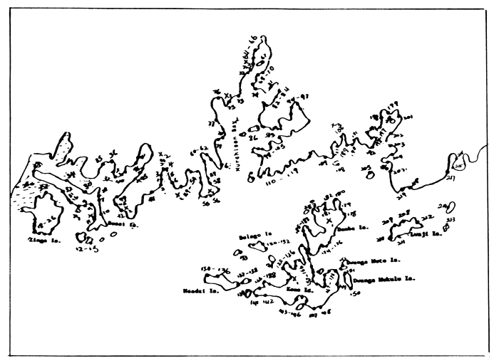
A sketch map showing the area covered by the survey team is attached as ANNEX II. The location of the landings is marked by dots and map code numbers (see Appendix III). The location of staff is marked by an X with a subscript number indicating the number of resident staff.
A total of 219 landings were identified by the team during the survey : 105 of these landings were found on the mainland while 114 were found in the islands. The team surveyed a total of 29 islands. A total of 2324 active boats, comprising both fishing and transport boats were recorded. Out of these, 236 (10.2%) boats were for transport only while 2088 (89.8%) were for fishing. 1315 boats were found on the mainland while the remaining 994 were found in the islands. A total of 418 (18%) boats were dug-out, 1906 (82%) were planked boats and 446 (19.2%) were powered boats.
The landing with the highest number of active canoes was Gaba
landing near Kampala which had a total of 70 canoes with 38
transport canoes, 32 fishing canoes, and 38 powered canoes.
This was followed by Kalungi (56) in Lwaje Island, Kigungu (50)
in Entebbe, Kinywante (48) in Bussi Island, and Kiwomolo (48) in
Lwaje Island. However, the landing with the highest number of
fishing canoes turned out to be Kalungi (51) followed by
Kinywante (47). The landing with the highest number of powered
canoes was also Kalungi (47) followed by Gaba with 38.
On the mainland, a total of 1270 active canoes, 176 transport
canoes, 1094 fishing canoes, 207 dug-out canoes, 1063 planked
canoes and 220 powered canoes were enumerated. On the Islands, a
total of 1054 active canoes, 60 transport canoes, 994 fishing
canoes, 210 dug-out canoes, 842 planked canoes and 226 powered
canoes were enumerated during the survey. The islands recorded
both a higher number of dug-out and powered canoes than the
mainland. Dug-out canoes were found mainly in swampy areas where
fishing is done near the shore line and in shallow waters.
6. WATER HYACINTH
Water hyacinth was observed at a number of the landings visited. At Kabula Landing (Damba Island) it was observed growing near the papyrus swamp. At Nyanama landing (Damba Island) some flowering plants were seen and fishermen claim to have noticed the plant for about a year now; a dense cover was also seen at the swampy side on the left when entering the landing. On Kisutu Island near Katosi Landing part of the shoreline is infested with the weed already in flowering stage. At Kayira Landing, on the mainland, some plants were seen which had been blown in by wind.
7. CONCLUSION
The conduct of the survey was very timely and useful. The use of water approach with the help of binoculars was very helpful in identifying all the landings. Before the conduct of the survey in the area, few landings were known and were being supervised. The results of the survey now give a clear picture of what is going on in the fishing industry. The RFO was also able to know his region well and it will improve on the supervision work.
APPENDIX 1
LIST OF ITEMS USED FOR THE FRAME SURVEY.
APPENDIX II
ITINERARY
Below follows the author's itinerary for the days spent in the field while supervising the frame survey team :
| 12/10/90 | Start of the Survey at Entebbe Pier landing, covering landings between the pier and Kitubulu fish landing. |
| 21/10/90 | Joined the team at Gaba fish landing and worked along the shoreline towards Katosi. Covered islands of Paradise and Soweto. Spent a night at Paradise Island. |
| 22/10/90 | Covered landings between Buwunga and Katosi landings Spent a night at Katosi. |
| 23/10/90 | Worked at Katosi Landing and return to Entebbe. |
| 31/10/90 | Joined the team at Gaba fish landing and set off for Kome Islands in the evening. |
| 01/11/90 | Covered landings on Kome main and some of the landings on Damba Island. Spent a night at Kakunyu Landing on Dwanga Mukulu Island. |
| 02/11/90 | Covered a landing on Dwanga Muuto island and the rest of the landings on Damba Island. Spent a night at Katosi landing. |
| 03/11/90 | Covered landings along the shoreline towards Kiyindi upto Kibanga port. Spent a night at Kisitu Island. |
| 04/11/90 | Covered landings in Bukwaya sub-bay, Wera bay, Dyabalume Island and 3 landings on Lwaji Island. Spent a night at Kalungi Landing on Lwaji Island. |
| 05/11/90 | Worked in Kalungi and Kiwololo landings on Lwaji Island; covered Ziru and Kerenge islands and crossed to Kiyindi Landing for a night. |
| 06/11/90 | Return to Entebbe. |
APPENDIX III
1. LIST OF LANDINGS IDENTIFIED DURING THE SURVEY.
| LANDING | MAP CODE | DISTRICT | MAINLAND/ISLAND |
| Botanical | 001 | Kampala | Mainland |
| Entebbe Pier | 002 | Kampala | Mainland |
| Quarantine | 003 | Kampala | Mainland |
| Kitinda Fishing Bay | 004 | Kampala | Mainland |
| Bukasa | 005 | Kampala | Mainland |
| Lwaka | 006 | Kampala | Mainland |
| Ggulwe | 007 | Mpigi | Island |
| Kinywante | 008 | Mpigi | Island |
| Kyanjazi | 009 | Mpigi | Island |
| Musomo | 010 | Mpigi | Island |
| Kikoko | 011 | Mpigi | Island |
| Lutale/Kavennyanja | 012 | Mpigi | Island |
| Kachanga | 013 | Mpigi | Island |
| Kisanafu | 014 | Mpigi | Island |
| Kituufu | 015 | Mpigi | Island |
| Mabuye | 016 | Mpigi | Island |
| Bulenge | 017 | Mpigi | Island |
| Kasambya | 018 | Mpigi | Island |
| Teefe | 019 | Mpigi | Island |
| Koja 1 | 020 | Mpigi | Island |
| Koja (Main) | 021 | Mpigi | Island |
| Bukito | 022 | Mpigi | Island |
| Kibamba | 023 | Mpigi | Island |
| Buganga 1 | 024 | Mpigi | Island |
| Buganga 2 | 025 | Mpigi | Island |
| Lubiri | 026 | Mpigi | Island |
| Balabala | 027 | Mpigi | Island |
| Makanaga | 028 | Mpigi | Island |
| Mukaka 1 | 029 | Mpigi | Island |
| Mabamba | 030 | Mpigi | Island |
| Kayengere | 031 | Mpigi | Island |
| Kasiiru | 032 | Mpigi | Island |
| Kanamirira | 033 | Mpigi | Island |
| Miziina | 034 | Mpigi | Island |
| Bitalo | 035 | Mpigi | Mainland |
| Mabira | 036 | Mpigi | Mainland |
| Nakubije | 037 | Mpigi | Mainland |
| Nakirama | 038 | Mpigi | Mainland |
| Lugumba | 039 | Mpigi | Mainland |
| Nangombe | 040 | Mpigi | Mainland |
| Bugonga | 041 | Kampala | Mainland |
| Kigungu | 042 | Kampala | Mainland |
| Musoli | 043 | Kampala | Mainland |
| Nakiyenje | 044 | Kampala | Mainland |
| Nakiwogo | 045 | Kampala | Mainland |
| Kyanvubu | 046 | Mpigi | Mainland |
| Buvi | 047 | Mpigi | Mainland |
| Kitubulu | 048 | Kampala | Mainland |
| Kasenyi | 049 | Kampala | Mainland |
| Kaingini | 050 | Kampala | Mainland |
| Kabo/Kagave | 051 | Kampala | Mainland |
| Bukaya | 052 | Kampala | Mainland |
| Katomi | 053 | Kampala | Mainland |
| Kagolomolo | 054 | Kampala | Mainland |
| Tende | 055 | Kampala | Mainland |
| Ggerenge | 056 | Kampala | Mainland |
| Mbiru-Buziba | 057 | Kampala | Mainland |
| Kagolomolo “B” | 058 | Kampala | Mainland |
| Bulega (Kawafu) | 059 | Kampala | Mainland |
| Kateebe | 060 | Kampala | Mainland |
| Kigga | 061 | Kampala | Mainland |
| Busoga | 062 | Kampala | Mainland |
| Bugiri (Kasenyi) | 063 | Kampala | Mainland |
| Ggaba | 064 | Kampala | Mainland |
| Kauku | 065 | Kampala | Mainland |
| Luzira | 066 | Kampala | Mainland |
| Namulusu | 067 | Mukono | Mainland |
| Mawoto | 068 | Mukono | Mainland |
| Bule | 069 | Mukono | Mainland |
| Kisinsi | 070 | Mukono | Mainland |
| Cape Town | 071 | Kampala | Mainland |
| Mulungu | 072 | Kampala | Mainland |
| Busaabala | 073 | Kampala | Mainland |
| Buzindere | 074 | Mukono | Mainland |
| Nakabugo | 075 | Kampala | Mainland |
| Mutungo | 076 | Kampala | Mainland |
| Dewe | 077 | Mpigi | Mainland |
| Bwerenga | 078 | Mpigi | Mainland |
| Kimbejja | 079 | Mpigi | Mainland |
| Sanga | 080 | Mukono | Island |
| Busoke | 081 | Mukono | Mainland |
| Katungulu | 082 | Mukono | Mainland |
| Nantwalantya | 083 | Mukono | Mainland |
| Tte | 084 | Mukono | Mainland |
| Kitebe | 085 | Mukono | Mainland |
| Paradise | 086 | Mukono | Island |
| Kachanga (Sowe) | 087 | Mukono | Island |
| Sowe (to) | 088 | Mukono | Island |
| Buwunga (Katoogo) | 089 | Mukono | Mainland |
| Kyawanvubu | 090 | Mukono | Mainland |
| Mpenja | 091 | Mukono | Mainland |
| Kiteredde | 092 | Mukono | Mainland |
| Buwunga | 093 | Mukono | Mainland |
| Ggobero | 094 | Mukono | Mainland |
| Bukule | 095 | Mukono | Mainland |
| Bbanga | 096 | Mukono | Mainland |
| Mugangu | 097 | Mukono | Mainland |
| Kisale | 098 | Mukono | Mainland |
| Nkone 1 | 099 | Mukono | Mainland |
| Nkone 11 | 100 | Mukono | Mainland |
| Kikukula (Buleebi) | 101 | Mukono | Mainland |
| Buleebi | 102 | Mukono | Mainland |
| Mawembe-Ttale | 103 | Mukono | Mainland |
| Mawembe-Buziba | 104 | Mukono | Island |
| Bulebi II | 105 | Mukono | Mainland |
| Katosi | 106 | Mukono | Mainland |
| Nakitokota | 107 | Mukono | Mainland |
| Mbeya | 108 | Mukono | Island |
| Kiringo | 109 | Mukono | Mainland |
| Kaazikake | 110 | Mukono | Mainland |
| Busoke | 111 | Mukono | Mainland |
| Busoke II | 112 | Mukono | Mainland |
| Mpunge | 113 | Mukono | Mainland |
| Kamwanyi | 114 | Mukono | Mainland |
| Kyazi | 115 | Mukono | Mainland |
| Lulaggwe | 116 | Mukono | Mainland |
| Nankoko | 117 | Mukono | Mainland |
| Lwazi | 118 | Mukono | Mainland |
| Kasaali | 119 | Mukono | Mainland |
| Lwazimiruli | 120 | Mukono | Island |
| Bbanga | 121 | Mukono | Island |
| Zingoola I | 122 | Mukono | Island |
| Zingoola II | 123 | Mukono | Island |
| Zingoola III | 124 | Mukono | Island |
| Kibanga | 125 | Mukono | Island |
| Kyazimba | 126 | Mukono | Island |
| Kisigala I | 127 | Mukono | Island |
| Kisigala II | 128 | Mukono | Island |
| Tavu | 129 | Mukono | Island |
| Kachanga | 130 | Mukono | Island |
| Banga | 131 | Mukono | Island |
| Kasaali | 132 | Mukono | Island |
| Kizima | 133 | Mukono | Island |
| Mpale/Kansambwe | 134 | Mukono | Island |
| Ttabaliro | 135 | Mukono | Island |
| Bugiri | 136 | Mukono | Island |
| Kimi | 137 | Mukono | Island |
| Kachanga (Kimi) | 138 | Mukono | Island |
| Ngamba | 139 | Mukono | Island |
| Ngaga/Kampindi | 140 | Mukono | Island |
| Navubuko | 141 | Mukono | Island |
| Sasa | 142 | Mukono | Island |
| Lubembe | 143 | Mukono | Island |
| Katuntu/ Masa | 144 | Mukono | Island |
| Katuntu/Luvu | 145 | Mukono | Island |
| Kasenyi | 146 | Mukono | Island |
| Musenyi | 147 | Mukono | Island |
| Kibungo | 148 | Mukono | Island |
| Namugambe | 149 | Mukono | Island |
| Kakunyu | 150 | Mukono | Island |
| Lugumba | 151 | Mukono | Island |
| Lwamga - Muto | 152 | Mukono | Island |
| Kagombe | 153 | Mukono | Island |
| Kamwanyi | 154 | Mukono | Island |
| Kaddu's landing | 155 | Mukono | Island |
| Bebe | 156 | Mukono | Island |
| Kabula | 157 | Mukono | Island |
| Bubembe ? | 158 | Mukono | Island |
| Muvo | 159 | Mukono | Island |
| Kakeeka | 160 | Mukono | Island |
| Bugwisa | 161 | Mukono | Island |
| Sama | 162 | Mukono | Island |
| Sama II | 163 | Mukono | Island |
| Sama III | 164 | Mukono | Island |
| Bugingo | 165 | Mukono | Island |
| Busi | 166 | Mukono | Island |
| Kalama | 167 | Mukono | Island |
| Nakwa I | 168 | Mukono | Island |
| Nakwa II | 169 | Mukono | Island |
| Siriro | 170 | Mukono | Island |
| Buje | 171 | Mukono | Island |
| Lwazi | 172 | Mukono | Island |
| Sanga | 173 | Mukono | Island |
| Katolo | 174 | Mukono | Island |
| Katolo II | 175 | Mukono | Island |
| Musenyu | 176 | Mukono | Island |
| Nambu | 177 | Mukono | Island |
| Nyanama I | 178 | Mukono | Island |
| Nyanama II | 179 | Mukono | Island |
| Mala | 180 | Mukono | Island |
| Kalyambuzi I | 181 | Mukono | Island |
| Kalyambuzi II | 182 | Mukono | Island |
| Kisu | 183 | Mukono | Island |
| Jalaja | 184 | Mukono | Island |
| Kazi I | 185 | Mukono | Island |
| Kazi II | 186 | Mukono | Island |
| Batwala | 187 | Mukono | Island |
| Batwala II | 188 | Mukono | Island |
| Bukwaya | 189 | Mukono | Mainland |
| Bubanzi I | 190 | Mukono | Mainland |
| Bubanzi II | 191 | Mukono | Mainland |
| Kisitu | 192 | Mukono | Island |
| Buwuka | 193 | Mukono | Mainland |
| Kijiko I | 194 | Mukono | Mainland |
| Kijiko II | 195 | Mukono | Mainland |
| Kyesimira (Namusenyi) | 196 | Mukono | Mainland |
| Bunankanda | 197 | Mukono | Mainland |
| Kibanga | 198 | Mukono | Mainland |
| Nsonga | 199 | Mukono | Mainland |
| Lunkulu | 200 | Mukono | Island |
| Namazina | 201 | Mukono | Mainland |
| Kigugo | 202 | Mukono | Mainland |
| Buwera | 203 | Mukono | Mainland |
| Nkwase | 204 | Mukono | Mainland |
| Lyabalume | 205 | Mukono | Island |
| Kayira | 206 | Mukono | Mainland |
| Nalyazi | 207 | Mukono | Mainland |
| Kaalo | 208 | Mukono | Island |
| Lwazi | 209 | Mukono | Island |
| Kaserere | 210 | Mukono | Island |
| Kalungi | 211 | Mukono | Island |
| Kiwololo | 212 | Mukono | Island |
| Ziru | 213 | Mukono | Island |
| Kerenge | 214 | Mukono | Island |
| Muvo | 215 | Mukono | Mainland |
| Kizizi | 216 | Mukono | Mainland |
| Nansagazi | 217 | Mukono | Mainland |
| Buyoba | 218 | Mukono | Mainland |
| Muyubwe | 219 | Mukono | Mainland |
| TOTAL NO. OF LANDINGS = 219 | |||
ANNEX I: SKETCH MAP SHOWING DEMARCATION OF SURVEY AREAS TOGETHER WITH SHEET NOS. OF 1:50,000 SCALE USED BY EACH TEAM.
ANNEX II: SKETCH MAP SHOWING THE AREA COVERED BY ENTEBBE REGION SURVEY TEAM TOGETHER WITH LANDINGS AND STAFF POSITIONS.
![]()
![]()
![]()