![]()
![]()
![]()
The Republic of Kenya (Fig. 1), almost equally divided by the equator, spreads over 582 644 km2 from about 34o to 41oE longtitudes and from 4oN to 4oS latitudes. Bordered in the east by the Indian Ocean (coastline 640 km), its continental landscape is dominated by a flight of plateaux and a few major mountain peaks, such as Mt. Kenya, Mt. Elgon, the Aberdare Range, and the Cherangani Hills.
The Kenyan drainage system results from tectonic and volcanic events associated with the formation of the Rift Valley. It comprises five distinct drainage basins (Fig. 1): Ewaso Ngiro, Tana River, Athi-Sabaki Rivers, Rift Valley and Lake Victoria. The Lake Victoria Basin is the smallest one, containing only 8.4% of Kenya's total area (Litterick, 1981). It covers about 44 500 km2 and includes the Western Province (Kakamega), the Nyanza Province (Kisumu) and the western part of the Rift Valley Province (Nakuru). It also includes the Kenyan sector (3 755 km2) of Lake Victoria (Fig. 2).
Kenya enjoys a very great topographical diversity, with a wide amplitude of relief, the altitudes varying from sea level to 5 199 m at the summit of Mount Kenya. Part of this diversity is found in the Lake Basin where altitude gradually increases from lake level (1 133 m ab. MSL) in the West to more than 3 000 m in the extreme East and North (Fig. 3).
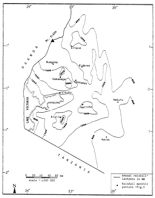
2.2.1 Rainfall. The annual mean rainfall in Kenya ranges from less than 255 mm in the northern and eastern areas to over 2 030 mm in the high mountain ranges. Wet belts extend along the Indian Ocean coast (about 95 km inland, from 1 525 mm at the coast to 510 mm) and east of Lake Victoria (from 510 mm at the shore to 2 030 mm in the mountains - Fig. 4).
In most of the Lake Basin there is no definite rain season although peaks of rainfall are on average experienced each year in April and May particularly (Fig. 5). A stronger seasonal pattern of rainfall exists in the northeastern part of the basin (max. March-September) and in the southeastern extremity (max. December-May), although there is no really dry season even in these areas. The mean annual rainfall in the Lake Basin (Litterick, 1981) is relatively high (1 245 mm) compared both to the other Kenyan drainage basins' values (255–585 mm) and to the national average (500 mm).
2.2.2 Air temperature. Mean air temperatures in Kenya are closely related to altitude. The annual mean temperature of a station (T in °C) can be estimated with fair accuracy as T = 30.2–6.5 E, where E is the elevation ab. MSL expressed in kilometres (Survey of Kenya, 1970). Various air temperatures may also be estimated locally on the basis of existing meteorological data by considering that they decrease with increasing altitude at the approximate rate of 1.7°C per 305 m (East African Meteorological Department, 1970). Annual temperature variations are generally less than 5°C, but the hourly temperatures differ considerably between night and day. Temperature ranges between maximum and minimum vary from 6°C at the coast to 16°C in the highlands.
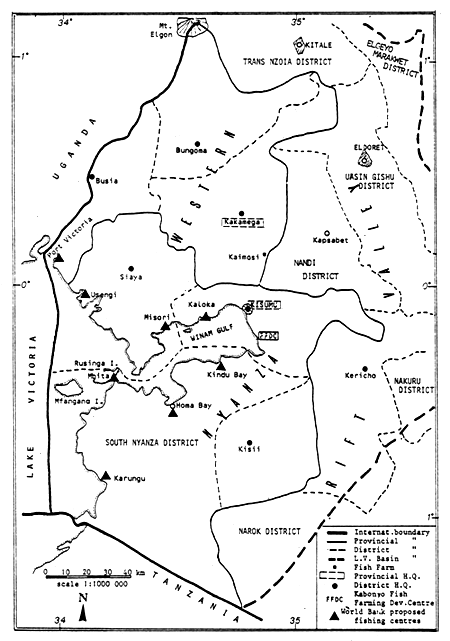
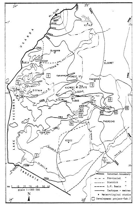
Figure 4. Distribution of the annual rainfall in the Lake Basin.
Air temperature in the altitude zones of the Lake Basin
| Meteorological Station (Annex 4) | MEAN AIR TEMPERATURE, °C | ||||||||||||||
| year | J | F | M | A | M | J | J | A | S | O | N | D | |||
| A. | ALTITUDE ZONE 1 100–1 300 m | ||||||||||||||
| Al. Mean max. to: | Kisumu | 29.4 | 30.6 | 30.8 | 30.3 | 28.8 | 28.2 | 28.0 | 27.7 | 28.2 | 29.4 | 30.5 | 30.2 | 29.9 | |
| Kibos | 29.0 | 30.8 | 30.7 | 29.5 | 28.1 | 27.8 | 28.0 | 27.8 | 28.3 | 28.9 | 29.6 | 29.2 | 29.6 | ||
| Ahero | 30.0 | 31.3 | 31.4 | 30.7 | 29.1 | 28.8 | 29.0 | 28.9 | 29.2 | 30.6 | 30.7 | 30.5 | 30.3 | ||
| Busia | 28.0 | 29.4 | 29.3 | 29.1 | 28.0 | 27.4 | 27.2 | 26.8 | 26.9 | 27.5 | 28.1 | 27.7 | 28.3 | ||
| A2. Mean air to: | Kisumu | 23.2 | 23.8 | 24.1 | 24.0 | 23.4 | 22.8 | 22.2 | 22.0 | 22.1 | 22.9 | 23.8 | 23.7 | 23.5 | |
| Kibos | 22.3 | 23.1 | 23.2 | 22.8 | 22.4 | 22.1 | 21.5 | 21.3 | 21.5 | 21.9 | 22.5 | 22.5 | 22.4 | ||
| Ahero | 23.0 | 23.3 | 23.7 | 23.8 | 22.9 | 22.8 | 22.3 | 22.3 | 22.3 | 23.0 | 23.2 | 23.0 | 22.8 | ||
| Busia | 22.0 | 22.5 | 22.6 | 22.9 | 22.4 | 22.0 | 21.5 | 21.3 | 21.2 | 21.6 | 22.3 | 22.0 | 22.1 | ||
| A3. Mean min.to: | Kisumu | 17.0 | 17.0 | 17.4 | 17.8 | 17.9 | 17.4 | 16.4 | 16.2 | 16.1 | 16.3 | 17.1 | 17.3 | 17.1 | |
| Kibos | 15.5 | 15.3 | 15.7 | 16.2 | 16.7 | 16.4 | 15.1 | 14.9 | 14.7 | 14.9 | 15.4 | 15.8 | 15.2 | ||
| Ahero | 15.9 | 15.3 | 15.9 | 16.9 | 16.8 | 16.8 | 15.6 | 15.7 | 15.4 | 15.3 | 15.7 | 15.6 | 15.3 | ||
| Busia | 16.0 | 15.5 | 15.9 | 16.6 | 16.8 | 16.5 | 15.7 | 15.7 | 15.5 | 15.6 | 16.4 | 16.2 | 15.8 | ||
| A4. Abs.min.to: | range | 9.0–14.4 | 10.0–11.0 | 10.0–12.8 | 11.7–13.0 | 12.8–14.4 | 11.0–14.1 | 9.0–12.4 | 10.0–12.2 | 10.0–11.5 | 10.0–12.4 | 11.1–13.9 | 11.1–12.8 | 9.8–12.0 | |
| B. | ALTITUDE ZONE 1 300–1 500 m | ||||||||||||||
| B2. Est.mean min.to (1 400 m) | 14.8 | 14.2 | 14.8 | 15.8 | 15.7 | 15.7 | 14.5 | 14.6 | 14.3 | 14.2 | 14.6 | 14.5 | 14.2 | ||
| B4. Est.Abs.min.to (1 400 m) | 7.9 | 9.5 | 10.4 | 10.6 | 13.3 | 9.9 | 7.9 | 11.1 | 10.4 | 10.9 | 12.8 | 11.1 | 8.9 | ||
| C. | ALTITUDE ZONE 1 500–1 750 m | ||||||||||||||
| C1. Mean max. to: | Koru | 28.1 | 29.5 | 29.6 | 28.9 | 27.4 | 26.9 | 26.8 | 27.0 | 27.0 | 27.9 | 28.5 | 28.3 | 29.0 | |
| Kaimosi | 25.9 | 26.8 | 27.4 | 27.1 | 26.5 | 26.0 | 25.3 | 23.8 | 24.9 | 25.9 | 25.7 | 25.4 | 26.2 | ||
| Kakamega | 25.8 | 27.1 | 27.2 | 27.7 | 26.0 | 25.8 | 25.2 | 24.4 | 23.8 | 25.0 | 25.3 | 25.7 | 25.9 | ||
| Kisii | 26.0 | 26.9 | 27.3 | 26.6 | 25.8 | 25.7 | 25.3 | 25.0 | 25.2 | 26.0 | 26.5 | 25.5 | 25.9 | ||
| C2. Mean air to: | Koru | 20.8 | 21.4 | 21.8 | 21.4 | 21.0 | 20.5 | 20.2 | 20.1 | 20.0 | 20.5 | 20.9 | 20.9 | 21.1 | |
| Kaimasi | 20.6 | 21.1 | 21.6 | 21.4 | 21.1 | 20.5 | 20.1 | 19.3 | 19.8 | 20.4 | 20.4 | 20.6 | 20.8 | ||
| Kakamega | 18.6 | 19.0 | 18.8 | 19.7 | 19.3 | 19.0 | 18.3 | 18.0 | 17.5 | 17.8 | 18.4 | 18.9 | 18.7 | ||
| Kisii | 19.3 | 19.3 | 20.1 | 19.5 | 19.5 | 19.5 | 18.9 | 18.5 | 18.8 | 19.2 | 19.5 | 18.8 | 19.1 | ||
| C3. Mean min.to: | Koru | 13.5 | 13.2 | 13.9 | 13.9 | 14.6 | 14.1 | 13.5 | 13.3 | 13.0 | 13.0 | 13.3 | 13.5 | 13.1 | |
| Kaimosi | 15.2 | 15.3 | 15.7 | 15.7 | 15.6 | 14.9 | 14.8 | 14.8 | 14.7 | 14.9 | 15.0 | 15.8 | 15.4 | ||
| Kakamega | 11.4 | 10.8 | 10.4 | 11.7 | 12.6 | 12.2 | 11.3 | 11.6 | 11.1 | 10.6 | 11.5 | 12.0 | 11.4 | ||
| Kisii | 12.5 | 11.7 | 12.9 | 12.4 | 13.2 | 13.4 | 12.5 | 12.0 | 12.3 | 12.3 | 12.4 | 12.1 | 12.2 | ||
| C4. Abs.min.to: | range | 4.4–11.0 | 5.0–10.0 | 4.4–10.6 | 5.0–10.3 | 7.1–10.1 | 6.9–8.3 | 6.7–10.0 | 7.4–10.1 | 5.0–10.0 | 5.0–10.6 | 7.2–10.7 | 7.5–11.0 | 5.5–10.0 | |
| D. | ALTITUDE ZONE 1 750–2 000 m | ||||||||||||||
| D1. Mean max.to: | Kitale | 25.0 | 27.1 | 27.1 | 26.2 | 25.2 | 24.6 | 24.0 | 22.9 | 23.5 | 24.4 | 24.8 | 24.4 | 25.8 | |
| D2. Mean air to: | Kitale | 18.3 | 18.8 | 19.5 | 19.2 | 19.0 | 18.7 | 17.7 | 17.4 | 17.4 | 17.6 | 18.1 | 17.8 | 17.9 | |
| D3. Mean min. to: | Kitale | 11.5 | 10.4 | 11.8 | 12.1 | 12.8 | 12.7 | 11.3 | 11.8 | 11.3 | 10.7 | 11.4 | 11.2 | 10.0 | |
| D4. Abs.min.to: | Kitale | 6.4 | 6.4 | 7.4 | 8.0 | 9.8 | 9.7 | 8.5 | 8.1 | 8.6 | 7.9 | 8.0 | 7.5 | 6.4 | |
| E. | ALTITUDE ZONE 2 000–2 250 m | ||||||||||||||
| E1. Mean max.to: | Eldoret | 24.0 | 25.2 | 26.1 | 26.2 | 24.7 | 24.0 | 23.3 | 21.8 | 21.8 | 23.7 | 24.1 | 23.6 | 23.9 | |
| Kericho | 22.2 | 24.0 | 23.8 | 23.6 | 22.3 | 22.1 | 21.3 | 20.5 | 20.7 | 21.9 | 22.1 | 21.9 | 22.7 | ||
| E2. Mean air to: | Eldoret | 16.7 | 16.8 | 17.2 | 17.8 | 18.0 | 17.1 | 15.9 | 15.7 | 15.6 | 16.2 | 16.9 | 16.8 | 16.4 | |
| Kericho | 15.7 | 16.4 | 16.5 | 16.6 | 16.2 | 15.8 | 15.0 | 14.8 | 14.8 | 15.2 | 15.5 | 15.7 | 15.7 | ||
| E3. Mean min. to: | Eldoret | 9.3 | 8.3 | 8.2 | 9.4 | 11.2 | 10.2 | 8.4 | 9.5 | 9.4 | 8.6 | 9.6 | 10.1 | 8.9 | |
| Kericho | 9.1 | 8.7 | 9.1 | 9.5 | 10.1 | 9.6 | 8.7 | 9.1 | 8.9 | 8.4 | 8.8 | 9.5 | 8.6 | ||
| E4. Abs.min.to: range | 1.6–6.1 | 1.6–2.5 | 2.6–2.8 | 3.4–5.6 | 6.0–6.1 | 4.9–6.0 | 4.4–4.5 | 4.9–5.5 | 5.2–5.6 | 4.5–5.4 | 4.5–4.2 | 3.6–5.6 | 3.6–5.0 | ||
For the Lake Basin, long-term air temperature data are available from 11 meteorological stations (Fig. 7), as summarized in Annex 4. These stations have been regrouped into five altitude zones, particular consideration being given to long-term air temperature values for monthly and yearly mean maximum, mean minimum, and general mean (max. + min./2), as well as to the monthly range of absolute minimum temperatures (Table 1 and Fig. 6). Unfortunately, no meteorological data are available for the 1 300–1 500 m altitude zone and air temperatures have been estimated from lower altitude stations as described above.
At altitudes lower than 1 500 m (Zones A and B), mean monthly air temperatures generally remain above 21°C and the absolute minimum temperatures rarely drop below 10°C. Zones C and D are very similar from these points of view, while Zone E (above 2 000 m alt.) is definitely cooler on the average. In particular, absolute minimum air temperatures mostly remain under 6°C, all the year round. Cool temperatures prevail from June to September, the length and the intensity of this cooler season being directly related to the altitude (Fig. 6).
On these bases, and from the practical fish farming point of view (Sec. 3.1.3), the following equivalences between mean air temperatures and altitudes are proposed for the Lake Basin:
| Altitude zone | Mean monthly air temperatures, °C | Abs. minimum temperature, °C | ||
| Maximum | Minimum | Mean | ||
| 1 100 – 1 300 m | 27 – 30 | 15 – 17 | 21 – 23 | 10 – 13 |
| 1 300 – 1 500 m | 27 – 29 | 13 – 15 | 20 – 22 | 9 – 11 |
| 1 500 – 2 000 m | 22 – 28 | 10 – 13 | 17 – 20 | 6 – 9 |
| 2 000 – 2 250 m | 21 – 25 | 8 – 10 | 15 – 17 | 2 – 6 |
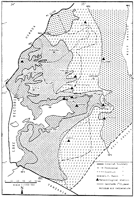
These climatic zones are tentatively materialized in Figure 7, through the combined use of isohypses (Fig. 3) and the above mean monthly minimum temperatures (MMT), shown as isotherms. Additional climatological stations would be necessary to define more accurately these zones.
A warmer belt extends in the immediate vicinity of the lake shore and further inland into the valleys of the major rivers, such as the Nyando, Nzoia and Sio Rivers. East of this warmer belt, most of the territory of the Western and Nyanza Provinces falls into the 13–15°C MMT climatic zone. Remarkable exceptions are the Kisii, eastern Kakamega, and northern Bungoma (part) Districts, which lie in the cooler 10–13°C MMT zone.
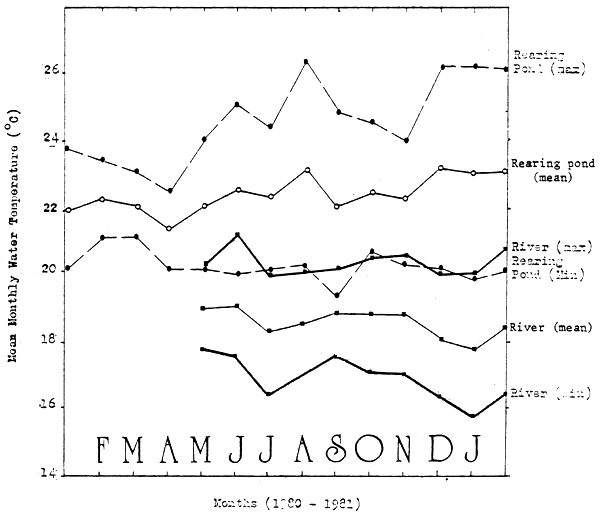
2.2.3 Water temperature. Data concerning water temperatures are only available for the Kaimosi Tea Estate (alt. 1 675 m) where they were measured using a maximum-minimum thermometer, in the local river and in the fish ponds (Fig. 8). At this altitude, pond water mean monthly temperature generally varies between 22°C and 23°C. Mean monthly minimum values vary around 20°C. In comparison with pond water, river water average temperatures are generally 4°C cooler.
It is to be expected that in areas where river water originates from much higher ground than the pond site, the cooling effect of the river water will be relatively important in the ponds. This will be particularly true in the eastern part of the Lake Basin, where the climate itself is already cooler.
Figure 5. Mean monthly rainfall in selected stations.
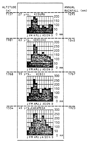
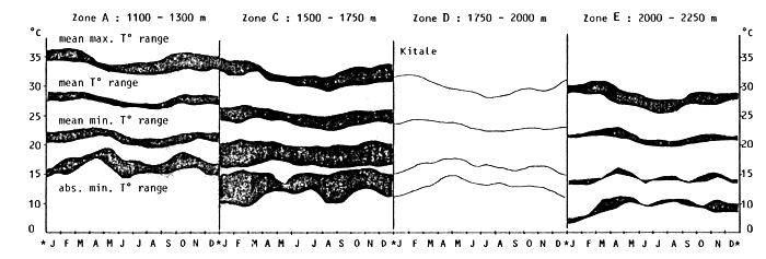
Figure 6. Ranges of monthly air temperatures in four altitude zones of the Lake Basin
Figure 7. Approximate thermal zonation in the Lake Basin
2.3.1 Rivers. The low rainfall coupled with high rates of evaporation and seepage into groundwater reservoirs greatly reduces in Kenya the water available for runoff to a low average 5% of rainfall. Only the Lake Basin makes exception, its runoff reaching 12% of rainfall, equivalent to about 6 705 million cubic metres per year. Kenya therefore does not have major inland drainage systems (Litterick, 1981). It possesses about 3 200 km of permanent rivers, of which even the largest ones (e.g. Tana River and Athi/Sabaki River) are small by African standards (Fig. 1).
The Lake Basin (Fig. 3) is a multi-river basin containing eight rivers of significant size (Ongwenyi, 1979). These rivers drain about 47% of total Kenya's runoff westward into Lake Victoria. Their catchment area and discharges are given in Table 2.
2.3.2 Natural lakes (Fig. 1). From the fisheries point of view, there are two major natural lakes in Kenya, Lake Turkana (6 405 km2 at alt. 375 m) and the Lake Victoria sector (3 755 km2 at alt. 1 133 m). A series of relatively smaller lakes exist in the Rift Valley south of Lake Turkana, of which the most important are Lake Baringo (129 km2 at 975 m) and Lake Naivasha (210 km2 at 1 884 m).
2.3.3 Man-made lakes and reservoirs. As a result of the construction of a series of dams across some of the major rivers such as the Tana River and the Athi River, series of manmade lakes have been or will be created.
A similar situation exists in the Lake Basin where it is proposed to build several dams for hydro power generation and irrigation purposes (Table 2).
2.3.4 Major irrigation schemes. Major irrigation schemes also have great water resources potential (Table 3). By 1981, close to 10 000 ha were irrigated in Kenya mainly for producing rice, sugar and cotton. Among these six schemes, three are located in the Lake Basin totalling about 2 800 ha distributed among 1 648 plot holders. The West Kano Scheme, south of Kisumu, uses lake water through a large channel and its pumping capacity reaches 15 000 1/min.
The development of other irrigation schemes in the Lake Basin are either under consideration or in construction, in practically all the river catchment areas (Table 2).
The general practice is for each licensed plot holder to reside on the spot, to be responsible for the maintenance of part of the irrigation canals, and to grow only one crop per year, the land lying fallow during the rest of the year. Overall supervision of the development is ensured either by the Provincial Irrigation Unit or by the National Irrigation Board (NIB), as for example for the Ahero, Bunyala and West Kano schemes.
In 1981, Kenya's total population was estimated at about 17 million (Table 4). It is projected that by the year 2 000, it will reach from 29 to 33 million.
There are actually in Kenya three major concentrations of population (Fig. 1): (a) the southern coastal area, where a zone of higher rainfall has favoured resettlement, especially south of the Athi/Sabaki River; (b) the Eastern Highlands, with relatively high rainfall, the highest population densities being reached on the rich volcanic soils of the slopes of the Aberdare Range and Mt. Kenya; and (c) western Kenya, with a long and relatively reliable rainy season.
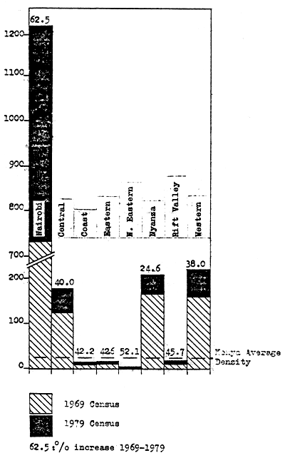
Population densities are particularly high in the Nairobi area and in the Central, Nyanza and Western Provinces (Fig. 9). For western Kenya, it was estimated in 1979 that the Lake Basin (8.4% of the land area) contained about 7 million people or more than 40% of the total Kenyan population. The two main provinces alone had close to 4.5 million inhabitants, equivalent to an overall average density of 215 inh/km2 (Table 5). The population density was particularly high in the Districts of Kisii and Kisumu (Nyanza) and in the District of Kakamega (Western). The main towns in the Lake Victoria Basin are as follows (Coûteaux, 1981): Kismu (150 000 inh.), Eldoret (50 000 inh.), Kisii (31 000 inh.), Kericho (30 000 inh.), Kitale (28 000 inh.), Bungoma (25 000 inh.) and Busia (25 000 inh.).
River catchments and their development in the Lake Basin
(according to Ongwenyi, 1979)
| River Catchment (Fig. 3) | Area km2 | Discharge | Existing or proposed (*) development projects | ||||
| Average | Annual 106 m3 | Location a | Volume (m = million) | Project | |||
| 1. Nzoia (Itobus, Malaba, Sosiani) | 12 696 | 1 846 3 571 | to | 1 777 | (a) Rambula* | 1 700 l/s | 50–100 000 ha under irrigation and 33 MW hydropower |
| (b) Bunyala | - | 253 ha irrigation | |||||
| 2. Mara | (8 941)b | 190 1 484 | to | 1 038 | Nyangores* | 198 l/s | 12–14 000 ha under irrigation and |
| 300 m m3 | 5 MW hydropower | ||||||
| 3. Cucha (Migori) | 6 368 | 212 1 294 | to | 952 | Gogo Falls | 425 l/s | 3.7 MW hydropower and 23 000 ha* (cotton, maize, sugar) under irrigation |
| 4. Kibos | 4 992 | 14 110 | to | 68 | - | - | - |
| 5. Sondu | 3 489 | - | 845 | (a) Kano* | 850 l/s | hydropower extensive irrigation (85 000 ha) | |
| (b) Kano Plain* | 170–255 l/s | ||||||
| 6. Nyando | 3 450 | 74 1 014 | to | 247 | (a) Ahero | 37–198 l/s | 1 370 ha irrigated rice with hydropower |
| (b) Tinderet* | 14.9 m m3 | 18 900 ha under irrigation | |||||
| (c) T. Bridge* | 17.2 m m3 | ||||||
| (d) Londiani* | 6.2 mm3 | ||||||
| (e) Koru* | 23.1 m m3 | ||||||
| (f) Awasi* | 20.0 m m3 | ||||||
| 7. Yala | 3 262 | 2 232 2 770 | to | 1 114 | (a) Yala Swamps | - | Max. 16 000 ha under irrigation irrigation and hydropower |
| (b) Nandi Hills* | 100 m m3 | ||||||
| 8. Sio (Malakisi) | 2 326 | 22 1 011 | to | 287 | - | - | - |
a for approximate location see Figure 3
b only partly in the Kenyan Lake Basin
Major irrigation schemes in Kenya
(1980-81 status from statistical abstracts, 1982)
| Scheme (watershed) | Size (ha) | Number Plot Holders | Main Crop & Yield (t) | Avg. Prod. (t/ha) | Annual Pot. Fish Prod. | ||
| (t/ha) | (t) | ||||||
| 1. Mwea | 5 771 | 3 150 | Paddy Rice = | 31 041 | 5.38 | 0.3 | 1 730 |
| 2. Tona River | 872 | 606 | Seed Cotton = | 2 337 | 2.68 | 0.1 | 90 |
| 3. Perkerra | 321 | 330 | Onions = | 1 127 | - | 0.1 | 20 |
| - | Chillies = | 603 | - | 0.1 | 10 | ||
| 4. Ahero* (Nyando R.) | 1 348 | 556 | Rice = | 4 326 | - | 0.3 | 330 |
| Sugar = | 1 477 | - | 0.1 | 30 | |||
| 5. Bunyala* (Nzoia R.) | 213 | 131 | Paddy Rice = | 995 | 4,67 | 0.3 | 65 |
| 6. West Kano* (L. Victoria) | 1 228 | 961 | Paddy Rice = | 3 583 | - | 0.3 | 50 |
| Sugar = | 11 395 | - | 0.1 | 75 | |||
| Totals | 9 753 | 5 734 | - | - | - | 2 400 | |
Figure 9. Population density in the various provinces, 1969 and 1979
The annual rate of population growth in Kenya as a whole has steadily increased from an estimated 3% in 1971 to 4% in 1981 (Table 4). It may now reach up to 7% in cities and it is considered to be the highest in the world. The current Development Plan (1979–1983) had proposed to contain annual population growth within 3.5%, but it would appear that it has not succeeded until now.
In the Lake Basin, annual population growth is generally smaller than the national average (Table 5). It is estimated to range from a low 1.9 – 2.1% in the districts of the Nyanza Province (average 2.1%) to a higher 2.8 – 4% in the Western Province (average 3.2%). Therefore relatively high population growth rates are expected in this last province only, in the Districts of Busia and Bungoma, where population densities are relatively lower (164 – 184 inh/km2).
Ninety per cent of the Kenya population is rural and it depends on agriculture for livelihood. The annual income of this rural population has been estimated from the 1974–75 census to average Ksh.3 652 per household (6.97 persons), equivalent to Ksh.524 per person (Kenya, 1977b). In the Western Province, rural income was much lower than this national average (Ksh.335), while in the Nyanza Province, it was slightly greater (Ksh.594). In 1979, the national average was estimated to be about Ksh.758 (Anon. 1980).
2.5.1 Land availability and land use for development. General land availability for agriculture averaged 86.2% in the development area of the Lake Basin, a relatively high figure (Table 6). In 1976, land under forest represented only 1.5% of the Nyanza Province and 5.2% of the Western Province area.
Intensity of land use in Kenya averaged 38.4% in 1976 (Table 6). In the Lake Basin, available land was more intensively used (50.1%), particularly in the Western Province (58.7%). Compared to other provinces, however, the latter ranked third, behind the Central Province (93.1%) and the Eastern Province (68.3%).
As a result of population growth (Sec. 2.4), it is generally believed that little high potential land remains today uncultivated. Additionally, pressure is increasing to develop lower potential lands such as forests and waters, but unfortunately it would appear that in western Kenya even such lands are limited in surface area (Table 6). Only 61 900 ha were under forest in 1976 and most probably even less today.
Average individual land availability expressed in hectares per inhabitant has been steadily decreasing (Table 5). Averaging 0.60 ha/inh. in the Lake Basin development area in 1969, it had dropped to 0.46 ha/inh. in 1979. It is estimated that by 1989 it will reach 0.32 ha/inh. (about half the 1969 value) and by 1999, 0.24 ha/inh. only. Provincial averages are very similar to these regional values, but a great variation is observed from district to district, directly related to population densities (Sec. 2.4). In 1979, the Kisii (Nyanza) and the Kakamega (Western) Districts were the worst off. Future projections confirm these lowest individual land availabilities.
2.5.2 Type of agricultural development in the Lake Basin. In 1974–75, a survey of rural holdings was made in the Nyanza and Western Provinces (Kenya, 1977b). Small-scale holdings accounted for 59.5 and 76.7% of the area respectively, while large farms accounted for only 2.1 and 0.7% (Table 7). From 55 to 71% of the small rural holdings had an annual income of less than Ksh.300, their total assets being valued at about Ksh.4 400 each.
Estimated population and fish availability in Kenya, 1971–81
| Year | Population (milliona) | Annual population growth (percentb | Fish availability | |
| t | kg/inh/year | |||
| 1971 | 11.9 | 3.0 | 28 564 | 2.4 |
| 1972 | 12.3 | 3.1 | 29 453 | 2.4 |
| 1973 | 12.7 | 3.2 | 29 026 | 2.3 |
| 1974 | 13.1 | 3.3 | 30 105 | 2.3 |
| 1975 | 13.6 | 3.4 | 27 545 | 2.0 |
| 1976 | 14.1 | 3.5 | 41 447 | 2.9 |
| 1977 | 14.6 | 3.6 | 40 889 | 2.8 |
| 1978 | 15.1 | 3.7 | 46 581 | 3.1 |
| 1979 | 15.7 | 3.8 | 48 947 | 3.1 |
| 1980 | 16.3 | 3.9 | 48 332 | 3.0 |
| 1981 | 17.0 | 4.0 | 60 000c | 3.5 |
| 1990 | 23.0 | |||
| 2000 | 29–33 | |||
a Based on various population projections, e.g., Senga et al. (1981)
b Fish availability takes into account the difference between imports and exports of edible fish
c From a recent press release by the Department of Fisheries (May 1982)
Estimated population and land availability in the Lake Basin, 1969–99
| Province district | Area 103ha | |||||||||
| 1969a | 1979b | 1989 | 1999c | Population increase % per year | ||||||
| 103inh | ha/inh | 103inh | ha/inh | 103inh | ha/inh | 103inh | ha/inh | |||
| Nyanza Province | ||||||||||
| Kisii | 220 | 675 | 0.33 | 867 (394)d | 0.25 | 1 270 | 0.17 | 1 680 | 0.13 | 2.1 |
| Kisumu | 209 | 401 | 0.52 | 480 (230) | 0.44 | 740 | 0.28 | 995 | 0.21 | 1.9 |
| Siaya | 252 | 383 | 0.66 | 472 (187) | 0.53 | 715 | 0.35 | 959 | 0.26 | 2.1 |
| South Nyanza | 571 | 663 | 0.86 | 815 (143) | 0.70 | 1 250 | 0.46 | 1 685 | 0.34 | 2.1 |
| Total Province | 1 252 | 2 122 | 0.59 | 2 634 | 0.47 | 3 975 | 0.31 | 5 319 | 0.23 | 2.1 |
| Western Province | ||||||||||
| Bungoma | 307 | 345 | 0.89 | 504 (164) | 0.61 | 690 | 0.44 | 875 | 0.35 | 3.6 |
| Busia | 163 | 200 | 0.81 | 300 (184) | 0.54 | 400 | 0.41 | 507 | 0.32 | 4.0 |
| Kakamega | 352 | 783 | 0.45 | 1 033 (293) | 0.34 | 1 490 | 0.24 | 1 950 | 0.18 | 2.8 |
| Total Province | 822 | 1 328 | 0.62 | 1 837 | 0.45 | 2 580 | 0.32 | 3 332 | 0.25 | 3.2 |
| Lake Basin Development Area | 2 074 | 3 450 | 0.60 | 4 471 | 0.46 | 6 555 | 0.32 | 8 651 | 0.24 | 2.6 |
a From Kenya, 1969
b Provisional Population Census (1979)
c Projected annual growth rates of population, after Senga et al. (1981)
d In parentheses, average population density, inh/km2
Land availability and land use, 1976 (acc. Kenya, 1981b)
| Kenya | Province | Lake Basin Devel. Area | ||
| Nyanza | Western | |||
| Total land area, 103 ha | 58 264.4 | 1 252 | 822 | 2 074 |
| Total agricultural land, 103 ha | 8 650.7 | 1 125.2 | 663.6 | 1 788.8 |
| , percent total land | 14.8 | 89.9 | 80.7 | 86.2 |
| Land under forest, 103 ha | 1 155.9 | 19.1 | 42.8 | 61.9 |
| , percent total land | 2.0 | 1.5 | 5.2 | 3.0 |
| Land available for agriculture, 103 ha | 7 494.8 | 1 106.1 | 620.8 | 1 726.9 |
| Land cropped, 103 ha | 2 876.3 | 501.2 | 364.5 | 865.7 |
| , percent land available | 38.4 | 45.3 | 58.7 | 50.1 |
Types of agricultural development in the Lake Basin, 1974–75
| Province | Nyanza | Western |
| Total area, 103 ha | 1 252 | 822 |
| Percent, area Kenya | 2.15 | 1.41 |
| Small-Scale Holdings | ||
- Number | 386 400 | 254 600 |
- Percent, total area | 59.5 | 76.7 |
- Percent cropped | 66.6 | 60.4 |
- Percent with annual income less than K.Sh. 300 | 54.8 | 70.7 |
- Total assets, K.Sh. | 4 357 | 4 471 |
| Large Holdings | ||
- Percent, total area | 2.1 | 0.7 |
- Percent cropped | 64.5 | 71.9 |
The average size of the rural family holdings surveyed was generally less than 3 ha in both provinces, but especially so in the Nyanza Province (Fig. 10). In the Western Province, about 16% of them were greater than 5 ha, while in both cases about 40% were smaller than 1 ha.
It is interesting to note that the vast majority of these rural holdings were situated less than one mile (1.6 km) away from fresh water, all the year round (Fig. 11).
![]()
![]()
![]()