![]()
![]()
![]()
5.1 Surface water utilization and development
5.2 Excavated reservoirs
5.3 Impounded reservoirs
5.4. Rainwater harvesting techniques
5.5 Concluding statement
Surface water is usually the main source of water for purely pastoral livestock in semi-arid regions. During the rainy season, precipitation over limited catchment basins runs off and concentrates in natural ponds where the soils are sufficiently impervious to prevent leaking. Most of these ponds dry out a few weeks after the end of the rainy season, due to the combined effect of evaporation and seepage. During the dry season, a great part of the livestock moves towards permanent surface water such as large rivers or permanent lakes or ponds. This method of utilization of surface water only requires leading the herds to water and is always preferred to groundwater by stockbreeders. However, sedimentation and location often make the rational use of surface water difficult and the improvement of the natural storage conditions desirable. Sanding up of ponds decreases their storage capacity until it becomes negligible so that the actual number of usable poinds is smaller every year. This phenomenon is aggravated by overgrazing and resulting desertification which makes the upper soil layers more sensitive to the wind and water erosion. The remoteness and uneven distribution of the permanent lakes and rivers during the dry season results in the overgrazing of the pasture lands surrounding the water supplied. Moreover the agricultural area increases to the detriment of the rangelands which become smaller while the livestock population tends to grow every year.
The main purposes of surface water development will be to increase the storage capacity of natural ponds to extend their period of utilization, and to create new surface water reservoirs in order to better the rangeland resources.
However, permanent water supplies will rarely be desirable because of the following factors:
a. In arid and semi-arid regions, runoff coefficients vary in the opposite direction with the size of the basin; the bigger the catchment basin, the lower the runoff coefficient. Therefore the quantities of water which can be collected by intercepting the runoff are usually small.b. Evaporation is high and may exceed 2 m/year which corresponds to the maximum depth of most of the ponds even after deepening.
c. Seepage also contributes Co loss of water in the surface reservoirs and the techniques of lining (with plastic or rubber sheets) are too costly in developing countries.
d. If significant permanent water supplies can be established they will probably be used for agriculture which is a much more profitable activity than extensive stockbreeding.
e. Permanent surface reservoirs in a hot climate are often subject to health hazards while parasitic diseases are much less common around non-perennial ponds.
Some general guidelines for excavated and impounded reservoir location design and construction follow for those who are not civil engineers. Ref. 14, 19, 21 and 63 are recommended for those wishing more detail. It is clear that larger excavated and impounded reservoirs are "water harvesting" devices broadly speaking, but the term is generally used for smaller storages where the tributary runoff area is treated to increase runoff. The basic methods to choose a drainage area and a storage volume are the same.
There is essentially a continuum in gradation between large reservoirs and cisterns. The subdivision of reservoirs which follows is arbitrary but the reader will observe that there are reservoirs which are excavated in one part to form an embankment, depending on topographic conditions. The arbitrary division is only for convenience. Small reservoirs are known by other names in many areas, particularly in Asia where they are usually called tanks.
5.2.1 Advantages and conditions of use
5.2.2 Selection of sites
5.2.3 Construction
5.2.4 Stock watering and protection of the pond
5.2.5 Maintenance
5.2.6 Case study and cost
An excavated reservoir is one of the simplest to construct and the only type of earth reservoir that can be constructed economically in relatively flat terrain. The fact that the capacity of these reservoirs is obtained by excavation limits their practical size, and they are best suited to locations where a comparatively small reservoir is sufficient, a small amount of runoff is expected, and impervious soils prevail.
Since they expose a minimum amount of surface area in proportion to their volume, they are advantageous in areas where evaporation losses are high and water scarce. Under such conditions, livestock can utilize a greater part of the available water. The ease with which they can be constructed, their compactness, their safety from flood-flow damage, their flexibility of location and their low maintenance requirements make their use popular in most of the semi-arid areas where extensive stockbreeding is the main activity. Improved natural ponds are also included in the same category of surface water storage system.
Excavated reservoirs are preferably located in the topographically low area of small closed drainage basins or in upland watersheds where the drainage divide is low and the topography is gentle. In some areas ancient sand dunes, now fixed by vegetation, form ideal closed areas.
In some regions excavated reservoirs reach the groundwater table and may become more or less permanent.
The location of stock watering reservoirs or ponds within a rangeland area is essentially determined by the nature of the soils and the hydrological conditions.
a. Nature of the soils
An adequate depth of impervious soil which can be easily excavated is essential for excavated reservoirs. If there is any doubt as to the nature of the soil, numerous test auger holes should be bored over the proposed reservoir area to determine the suitability of the soil and particularly the permeability of the sub-soil strata. Sites with porous soils or with underlying strata of sand, gravel, fissured limestone and other porous materials should not be selected unless such strata are not of sufficient magnitude to cause trouble. Actually the easiest way for identifying possible sites for an excavated reservoir with the best probability of success is to select an area where water naturally accumulates or has accumulated and where clayey deposits cover a large area. In any case the thickness of the clayey layer has to be checked by test holes before deciding on the suitability of the site for excavating a reservoir or deepening a natural pond. However, it is possible to select a site even in case of insufficient clay thickness provided that during the construction work, the clay is carefully put aside and then spread again and compacted over the bottom of the reservoir after excavation.
If hard rock is found costs of excavation will increase greatly.
Where there is no opportunity for studying the characteristics of the soil with adequate apparatus, some indication of the permeability of the soil can be obtained by filling test holes with water or by forming suitable containers from samples of soil and filling them with water. The holes or containers may be filled several times or puddled if necessary to represent conditions at the reservoir site. Observation of seepage will indicate what may be expected from the planned reservoir.
The fact that a reservoir may lose considerable water Immediately after excavation does not necessarily mean that it will be unsatisfactory: frequently new reservoirs do not retain water satisfactorily until they become sealed. This may require several months or even a year or more, depending on the soil type and on the quantity of fine material transported by the runoff water.
b. Hydrological conditions
Before undertaking the excavation work, it is necessary to estimate the probability of filling the reservoir by the expected water supply (usually runoff water). The hydrological investigations which can yield reliable information are usually lengthy and expensive so that, if such studies are envisaged, it should be checked that their cost does not exceed a fraction of the total construction cost. This is likely to happen only in the case of large reservoirs which may justify preliminary hydrological studies. In most cases the preliminary investigations will be limited to an enquiry with the local inhabitants and, in the case of already existing ponds, to a careful survey of the trails of mud which give evidence of the water extension during the wet season.
Where possible the drainage area should be chosen to minimize sediment runoff into the pond and the drainage area should be relatively small.
a. Shape
Although excavated ponds can be built to almost any shape desired, a rectangle is commonly used in relatively flat terrain. The rectangular shape is popular because it is simple to build and can be adapted to all kinds of excavating equipment.
The side slopes should be as flat as possible for easy access of the livestock unless the pond is planned to be fenced and equipped with external watering troughs. In that case a slope ranging from 2/1 to 3/1 may be acceptable. If one or two sides are of firmer material their slopes could be steeper.
b. Building the pond
The reservoir area should first be cleared of vegetation. The next step is to mark the outside limits of the proposed excavation with stakes indicating the depth of cut from the ground to the pond bottom.
In semi-arid areas where water is unlikely to accumulate in the excavation during the work period, any kind of available equipment can be used. Normal tractors equipped with a bulldozer blade or simple bulldozers are generally used. But if the waste material has to be transported far away from the excavation, additional equipment (power shovel and trucks) may be needed. For small reservoirs located in areas where manpower is not a constraint, hand operation can be envisaged at least for the digging work, while the transport of the waste material may be assigned to animals like mules or donkeys.
If the thickness of the impervious upper layer is insufficient when compared to the planned depth of the pond, the topsoil should be temporarily stockpiled for later use as sealing layer over the bottom of the pond. In that case, the clayey material should be properly compacted after it has been spread and moistened.
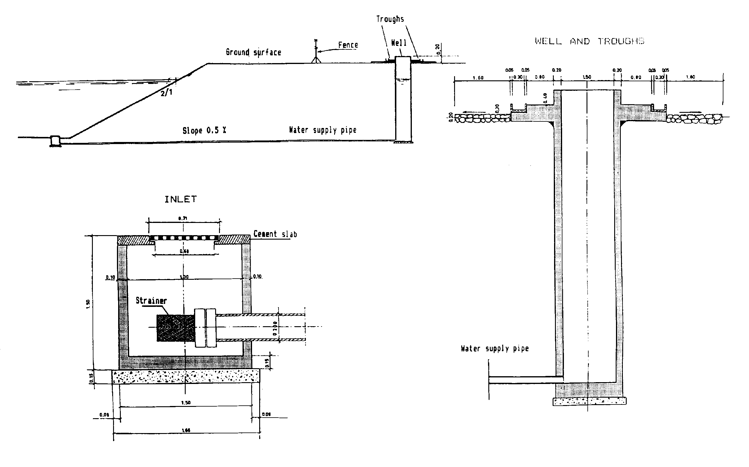
Complete fencing of the reservoir is usually recommended to avoid damaging by trampling and water pollution by livestock. When the pond is fenced a watering system has to be installed outside the fenced area and may consist of several troughs set up around a well fed through a water supply pipe that runs below the bank of the pond. The water inlet inside the reservoir should be protected against clogging by a strainer made of a piece of screen. The pipe itself may be of small diameter, 2 inches for example, arid made of steel or plastic. Figure 5 shows a typical water piping and trough system for stock watering from a fenced pond (from Techniques Rurales en Afrique - BCEOM/IEMVT, 1973).
Although fencing ponds for stock watering is highly recommended in all handbooks dealing with extensive stockbreeding, it should be mentioned that the advantages usually derived from fencing ponds in developing countries are often more than offset by the increasing cost and maintenance requirement and by the fact that fewer animals can water at one time. Moreover, it is extremely difficult in hot climates to prevent livestock (and sometimes herders) from destroying fences which they consider as an unjustified obstacle to reach water when they are thirsty.
A pond, no matter how well planned and built, must be maintained in order to preserve its storage capacity as well as a proper functioning of the watering facilities, if any, throughout its expected life. When fenced, a pond needs a permanent maintenance in order to ensure the integrity of the fence during the whole period of presence of water in the reservoir, but this constraint is so costly that watching and maintenance are not sufficient and the fences disappear a few weeks after the pond has come into operation. This experience usually results in the planner giving up the fencing of ponds.
In the case of non-fenced ponds, the main objective of maintenance is to remove the wind or water transported material which accumulates and decreases the storage capacity of the pond. This operation is necessary every 4 to 5 years.
An example is given for excavated reservoirs (natural pond improvement) in Mali, within the 6th Region. The main characteristic of that region is the presence of a large area inundated by the Niger river covering 38 000 km2 This particular area called "Delta Interieur du Niger" plays an important role in the livestock management of the 6th Region since it contains important vegetal resources (essentially an aquatic grass known as "bourgou") which is exploited from November to May - i.e. during the dry season - by as many as 1.6 million bovidae representing 25 percent of the total livestock in Mali. Immediately after the beginning of the rainy season most of the cattle transhumes to the Northwest, North and Northeast in order to exploit from June to October, the natural ponds and rainfed fodder resources of the Sahelian rangelands. When moving from the Delta to the Sahel or from the Sahel to the Delta, the herds always take fixed itineraries, well visible on aerial photographs and even on satellite imagery since these axes of transhumance may be 200-300 metres wide. Along these routes, the livestock need watering and a programme of a first phase of pond improvement including 20 sites located west of the Delta was established in 1975 and implemented in 1978-79.
An enquiry carried out in 1979 on 7 ponds out of the 20 which were dug indicated that in one season about 638 000 cattle and 187 000 sheep and goats have watered during a total of 569 days corresponding to an average of 1120 cattle and 328 sheep and goats per day and per pond during 81 days.
In 1978-79, the cost of deepening the 20 existing ponds by a private contractor was Malian Francs (FM) 206 166 344. The preliminary studies and the supervision of the work were carried out by the Malian Administration (Service du Genie Rural) and cost FM 22 700 000. The total cost of the 20 ponds, each one of 2500 m3 average useful capacity, amounted therefore to FM 228 866 344 in 1979 - i.e. approximately US$ 380 000 or US$ 19 000 per pond.
Figure 5: Watering facilities outside the reservoir area
A new programme of pond improvement was established in 1983 including 45 sites located West and East of the Niger Internal Delta. The average capacity of the ponds is expected to be 5000 m3/pond - i.e. twice as much as for the ponds deepened in 1979. Table 9 shows a summary of the estimates costs for the preliminary surveys, the excavation work itself and the supervision. The total amount as estimated in the Preparation Report for the 2nd Phase Project (FAO 1983) corresponds to approximately 972 million FM - i.e. US$ 1.6 million or US$ 36 000 per pond. The average cost per pond is therefore twice as much as in 1979, but the average cost per cubic metre capacity is approximately the same.
Table 9: COST ESTIMATE FOR DEEPENING 45 PONDS IN MALI (FAO 1983)
|
|
Quantity of work |
Unit price in Malian FR |
Total cost in 1000 FM |
||||
|
Unit |
West Delta |
East Delta |
Gourma sud Seno-Mango |
Total |
|||
|
Number of ponds |
Unit |
13 |
15 |
17 |
45 |
|
|
|
Average capacity/pond |
M3 |
5080 |
5250 |
5750 |
|
|
|
|
Description of Work |
|||||||
|
Clearing of brushwood |
M2 |
4 332 |
14 900 |
0 |
19 232 |
38 |
731 |
|
Removing stumps and root |
Unit |
0 |
40 |
206 |
246 |
6 400 |
1 574 |
|
Digging |
M3 |
66 026 |
78 690 |
97 600 |
242 316 |
2 150 |
520 979 |
|
Digging hard soil (add) |
M3 |
0 |
0 |
45 000 |
45 000 |
3 000 |
135 000 |
|
Spreading material |
M3 |
3 306 |
3 400 |
4 630 |
11 336 |
4 400 |
49 878 |
|
Banking up |
M3 |
0 |
9 500 |
0 |
9 500 |
2 650 |
25 175 |
|
Removing rocks |
M3 |
0 |
100 |
0 |
100 |
30 000 |
3 000 |
|
Compacting |
M3 |
24 426 |
9 500 |
4 630 |
38 556 |
104 |
4 010 |
|
Transporting material |
M3/100M |
2 656 |
82 000 |
0 |
84 656 |
156 |
13 206 |
|
Moving track |
km |
217 |
529 |
154 |
900 |
70 400 |
63 360 |
|
Equip site out of track |
km |
43 |
54 |
32 |
129 |
96 400 |
12 436 |
|
to site diffi ground |
km |
10 |
18 |
0 |
28 |
162 600 |
4 553 |
|
Pumping water |
M3 |
5 776 |
9 000 |
0 |
14 776 |
970 |
14 333 |
|
Mob/demob to operat area |
Unit |
13 |
15 |
17 |
45 |
150 000 |
67 500 |
|
Sub total in 1000 FM |
915 735 |
||||||
|
Supervision (4% cost of work) |
36 629 |
||||||
|
Preliminary surveys (lump sum) |
19 520 |
||||||
|
TOTAL in 1000 Malian Francs |
971 885 |
||||||
|
Equivalent in US dollars |
1 619 808 |
||||||
|
Average cost per pond in US dollars |
36 000 |
||||||
This example shows the main items to be considered for preparing a cost estimate for excavating surface water reservoirs. The unit prices of course will differ.
An impounded reservoir, also called embankment pond, is made by building an embankment or earth fill across a narrow valley so that, while excavated reservoirs usually consist of improving an existing situation (natural ponds), the impounded reservoirs create a completely new surface water storage structure.
Excavated reservoirs are preferably located at the lower end of small and closed watersheds which may be part of longer catchment basins cut in several isolated sub-basins by natural weirs usually made of ancient fixed dunes. On the contrary, the impounded reservoirs are intended to intercept runoff from open watersheds. This important difference has the following consequences for the impounded reservoirs. The volume of runoff water is often bigger than the capacity of the reservoir itself so that it is usually necessary to provide a spillway to bypass surface runoff after the pond is filled. The implementation of impounded reservoirs requires a more accurate estimate of the surface runoff than for excavated reservoirs since both the embankment and the spillway have to be designed accordingly.
In semi-arid areas the reservoirs built for watering livestock are necessarily of small capacity for the following reasons:
a. if natural conditions make it possible to build a large artificial reservoir, its water is certainly going to be used for agriculture rather than for extensive stockbreeding;b. if for any reason agriculture is not feasible, an easy access to water for a great number of animals is not to be recommended because of the risk of overgrazing the nearby rangelands.
Therefore the impounded reservoirs for watering livestock in semi-arid countries will usually have a small to moderate capacity (from a few thousands to a few tens of thousands cubic metres) and consequently be usable only part of the average year (from a rainfall point of view). They rarely can be the only source of water supply for livestock on permanent rangelands. Limiting the size of ponds is one way of providing some degree of management of the grazing resources.
Selecting a suitable site for the impounded reservoirs is important and preliminary surveys are needed before final design and construction. However, this manual is not intended to be an exhaustive handbook for dam construction and the purpose of the indications given hereafter is just to draw the attention to some important points which have eventually to be studied by a specialist.
a. Morphological characteristics
A good site is where a dam can be built across a narrow section of a valley, the side slopes are steep and the slope of the valley floor permits a large area to be flooded. Sites where water may expand over large areas under shallow depth should be avoided since they would expose a large surface of shallow water to high evaporation.
b. Adequacy of the drainage area
The contributing drainage area should be large enough to fill the reservoir at least 8 years out of 10. However the drainage area should not be so large than expensive overflow structures (spillways) are needed to bypass excess runoff during storms. Where rainfall is not too variable the drainage area can often be chosen to have a minimum cost overflow. However, in many semi-arid areas this is not the case and irregular, high intensity storms of short duration may cause extensive damage if proper spillways are not constructed.
The amount of runoff that can be expected from a given watershed depends on so many interrelated factors that no set rule can be given for its determination. The physical characteristics that directly affect the yield of water are relief, soil infiltration, evaporation rate, plant cover and surface storage.
c. Nature of soils in the ponded area
Suitability of a pond site depends on the ability of the soils in the reservoir area to hold water. The soil should contain a layer of material that is impervious and thick enough to prevent excessive seepage. However, the presence of a surface layer of sand or other permeable material does not necessarily mean that the proposed sites should be abandoned; these pervious layers may just be an alluvial deposit covering an impervious bedrock.
In most cases detailed investigations including auger holes and laboratory tests should be carried out.
d. Foundation conditions
Particular attention should be paid to the nature of the soils at the proposed dam location in order to ascertain that the foundation would ensure stable support for the structure, and provide the necessary resistance to the passage of water.
Good foundation materials, those that provide both stability and imperviousness, are a mixture of coarse and fine textured soils like gravel-sand-clay or sand-silt-clay mixtures.
When the soil beneath the dam location is able to ensure the stability but not the imperviousness, a cut-off core of impervious material must be installed under the dam.
e. Fill material
The availability of suitable material for building a dam is a determining factor in selecting a pond site. Enough suitable material should be located close to the site so that placement costs are not excessive.
Materials selected must have enough strength for the dam to remain stable and be tight enough when properly compacted, to prevent excessive or harmful percolation of water through the dam.
The best material for an earthfill dam contains particles ranging from small gravel to fine sand and clay in the desired proportions. The material should contain about 20 percent by weight of clay particles. Though satisfactory earthfills can be built from soils that vary from the ideal, the greater the variance, the more precautions needed.
As for the foundations, if the material selected for the earthfill is pervious, a core of clay material has to be placed in the centre of the fill.
f. Spillway requirements
The function of a spillway is to pass excess storm runoff around the dam so that water in the pond does not rise high enough to damage the dam by overtopping.
Emergency spillways for small dams in semi-arid countries should have the minimum capacity to discharge the peak flow expected from a storm of a frequency of 1 year in 10 and a duration of 24 hours. As a very rough estimate it is possible to use the following formula (derived from Figure 15 of Agricultural Handbook No. 590, USDA) corresponding approximately to the most usual situation in semi-arid countries. For a small drainage area (from a few hectares to a few square kilometres) with moderate slope over the drainage area and with moderately permeable soils,
D = 1.84 x A0.675
in which D is the peak discharge in litres per second per millimetre of maximum daily rainfall with a frequency of 1 year in 10 and A is the drainage area in hectares.
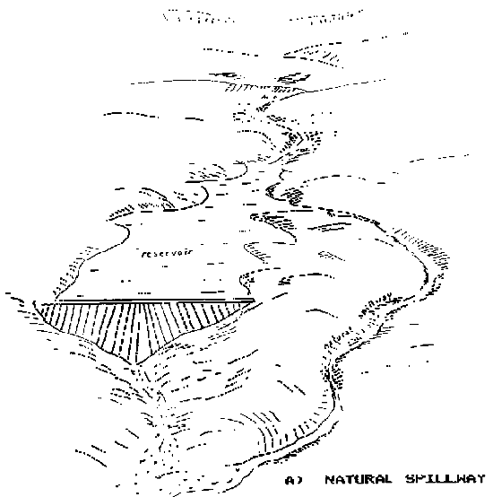
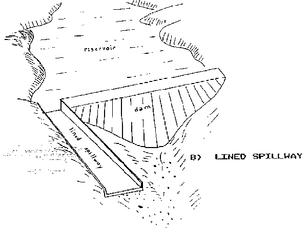
In mild climates, the protection of the spillways against erosion is obtained by installing herbaceous vegetation on the bottom of the spillway. This solution cannot apply in semi-arid climates where the spillways are usually of two different types. One type is the natural spillway, a secondary drainage which runs parallel to the main valley and needs only minor adjustments to bypass the excess storm water (see Figure 6a). The other is the lined spillway where no natural saddle is found. An artificial spillway has to be excavated beside the dam and then lined with stones, concrete or asphalt (see Figure 6b). The lined spillway is more expensive than the first one.
The ideal solution might consist of selecting a site or oversizing the dam in such a way that a spillway would not be required. But, because of the great variability of rainfall and consequently of runoff, such a solution is rarely feasible in the more arid areas. Either the catchment basin has to be very small and for most years the reservoir would remain empty or the benefit gained by eliminating the spillway would be more than offset by the increased cost of the dam.
g. Design of the dam
The detailed design of a dam, even if it is small, cannot be treated here in the framework of this manual. The main points which have to be taken into consideration are:
i. a water supply pipe through the dam is needed for the stock water troughs;
ii. cutoffs through the foundation and the dam itself may be needed in order to ensure tightness;
iii. the top of the dam should be wide enough to ensure the stability;
iv. side slopes upstream and downstream should be low enough to prevent collapse.
5.4.1 Preliminary considerations
5.4.2 Methods for improving catchment runoff efficiency
5.4.3 Building water storage tanks
5.4.4 Case study and cost
Water harvesting consists of collecting and storing water from an area that has been treated to increase precipitation runoff.
A water harvesting system is composed of a catchment or water collecting area, a water storage structure, and various other components such as piping, evaporation control and fencing.
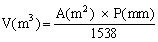
Assuming that 65 percent of the precipitation water can effectively be harvested, the quantity of water (V) which can be collected and used, after deduction of losses, from a catchment area (A) with an average annual raingall (P) can be estimated by the following formula:
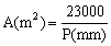
If the annual water requirement for one adult cattle is assumed to be approximately 15 m3, including the losses around the watering troughs, the corresponding catchment area A can be estimated by the proceeding formula rewritten as follows:
For example, in an area receiving an average annual rainfall of 200 mm, the catchment necessary to collect enough water 1 year out of 2 for one adult cattle would be 115 m2. If the same water supply has to be reliable 8 years out of 10, the value of rainfall taken into account in the formula should be 100 mm instead of 200 (see Figure 4 Rainfall probability) so that the catchment area required would become 230 m2.
FIGURE 6: DIFFERENT TYPES OF SPILLWAY
Natural spillway
Lined spillway
In general the use of water harvesting techniques in semi-arid areas of developing countries is limited because of the cost involved for treating large catchment areas and for building water storage facilities. Where hard rocks are exposed, collection of rainwater in cisterns has been used for centuries in North Africa in the 100-150 mm rain zone. In these areas the rock is hard at the surface but softer below so that cisterns are easy to excavate.
The methods used to increase runoff include vegetation management, land alteration, chemical treatment and soil cover.
These methods are widely used in Australia and in United States. Vegetation management is, for obvious reasons, not applicable in semi-arid countries, while treating soil surfaces to prevent infiltration is too costly for developing countries. However, areas of bare rock require minimum treatment, mostly to channel the water to a cistern.
a. Land alteration
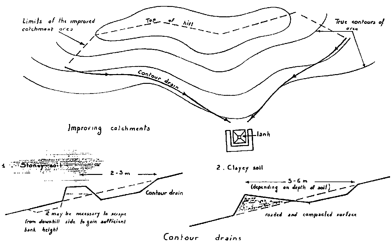
Collecting banks and contour drains
Land alteration is often the simplest and least expensive method of water harvesting when it involves nothing more than building walls or ditches to collect runoff from existing or manmade catchments such as rock outcrops or roads.
The purpose of the dykes is to increase the catchment area corresponding to the planted storage.
A similar method consists of digging drains almost parallel to the natural topographical contours with the purpose of draining water from a bigger catchment area. Figure 7 illustrates this method.
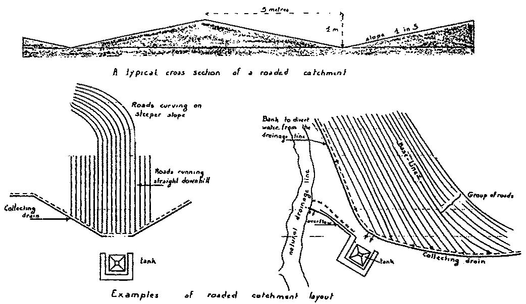
Roaded catchments
In the roaded catchment (Fig. 8) the soil is compacted by heavy rollers to make it more impervious. Each road is 8 to 10 metres wide and is separated from the next one by a Vee drain running parallel to the roads and collecting the water to the main drain o directly to the tank. When properly shaped from suitable materials the best roaded catchments can be almost as effective as bitumen surface. The efficiency of roaded catchment is due partly to the camber (degree of slope from crest to trough) and partly to the water shedding ability of its surface: the steeper the camber and the more impermeable the surface, the more readily will the catchment shed water. Usually it is not possible to achieve a camber steeper than 1 to 4 and it is undesirable to have it less than 1 to 8. Although this method is claimed to be very cheap (Carder 1970), it does not seem to be applicable in semi-arid areas of most developing countries. Difficulties include:
i. soils should be such (sand and clay) that they become impervious by. compaction and allow ater to be conveyed through unlined drains;ii. fencing of the whole catchment is necessary;
iii. permanent maintenance of the catchment is necessary to preserve the efficiency of the system.
b. Chemical treatment
The paraffin-wax treatment is being used at selected installations in the hotter regions of Arizona for providing livestock with drinking water. This treatment consists of applying a low-melting pount paraffin-wax, usually sprayed onto a prepared catchment surface in a molten form. The wax when heated by the sun penetrates the soil to a depth of 1 to 2 cm, coating each sol] particle with a thin wax film and creating an efficient water repellent surface.
Although paraffin-wax treatment has proved to be relatively low in cost in the United States and remarkably efficient when properly applied on well prepared catchments, the wax does not provide significant soil stabilization and needs a careful permanent maintenance. Moreover the whole catchment should be fenced in order to avoid trampling by livestock. This method therefore is also not applicable in most developing countries.
c. Soil cover
Before installing a catchment soil cover, the soil surface should be cleared, smoothed and compacted. Dykes around the perimeter of the apron are usually necessary to collect water and direct it to the storage. Several types of soil cover are in use mostly in Australia and the United States. Although these techniques are not easy to extrapolate to developing countries because of the high level of maintenance required, a short description is given hereafter of four methods. Details on the material and installation procedures can be found in the Handbook of Water Harvesting (Frasier and Myers 1983).
Asphalt-fabric membranes
This is a field-fabricated membrane of an inert fabric saturated in-place on the prepared catchment surface with a water-based asphalt emulsion. The water in the asphalt emulsion partially softens the fabric, allowing the membrane to conform to the irregularities of the catchment surface. The asphalt emulsion soaks through the fabric Co bond a layer of soil to the underside of the membrane, which provides additional weight to the vovering. During the curing process, the asphalt hardens, forming a semi-rigid membrane with high tear strength. The asphalt cements the fabric threads and seals the pore spaces.
Properly installed and maintained, asphalt fabric membranes are highly resistant to mechanical damage and deterioration by weathering processes. The asphalt hardens slowly and, within 6 to 12 months, the membrane becomes semi-rigid and cattle can walk on Its surface without causing damage. This may not apply in the case of very hot climates where the asphalt may soften.
The material with a proper maintenance has a projected life in excess of 20 years, but new asphalt emulsion coats for the entire catchment (1 to 1.5 litres/m2) are usually required at 3- to 5-year intervals.
The initial cost of material in 1981, including the seal coat asphalt was approximately US$ 1.75 to 2.00 per m2 in the United States. It is clear that costs of material and installation might be much higher in developing countries (perhaps multiplied by a factor of 3 to 4).
A disadvantage of this method is that the runoff water from the asphatic surface is often discoloured by asphalt oxidation by-products in low rainfall areas with high solar radiation.
Gravel covered sheetings
The treatment consists of a waterproof membrane such as polyethylene or roofing tar paper on the prepared catchment surface and covered with a shallow layer of uniform-sized gravel. In some installations an asphalt emulsion tack coat is used to bond the membrane to the soil and/or the gravel to the membrane. The purpose of the gravel is to protect the membrane from sunlight weathering processes and to provide some resistance to minor mechanical damage.
When properly installed and maintained, the gravel covered membrane treatment is rather resistant to weathering deterioration and has a projected life of 15 to 20 years.
The main disadvantage of this treatment is due to its extreme susceptibility to mechanical damages so that fencing of the whole catchment is necessary, but even with this precaution, a continuous maintenance is required to repair holes and punctures from rodents or mechanical sources.
Artificial rubber membranes
Artificial rubber (butyl) fabrics are flexible membranes relatively easy to install but have disappointing performances due to high susceptibility to mechanical damages of any origin, including:
i. holes caused by rodents or birds,
ii. wind vibrating the membrane against the ground,
iii. stress deterioration due to surface irregularities.
In conclusion the artificial rubber membrane treatment is not easily applicable in developing countries because of so many constraints related to installation, protection and maintenance as well as cost.
Sheet metal coverings
This type of covering is mentioned here although very limited applications can be considered in developing countries for the following reasons:
i. high cost of material and installation,ii. careful installation required and coating of metal to prevent rusting,
iii. high level of maintenance required to permanently ensure that sheets are held firmly in place and do not allow wind to penetrate underneath.
Concrete
Because of high cost of material arid labour required for installation, concrete covers can only be considered for very small artificial catchments.
a. Steel rim tanks
These tanks consist of a vertical wall, cylindrical steel rim with a waterproof membrane liner inside. Typical capacities range from 20 to 300 m3 (1 to 5 m high, 5 to 15 m diameter). They are used for aboveground or semi-buried installations.
The tanks are usually formed from flat or corrugated steel sheets pre-rolled to the required radius of curvature and zinc coated to prevent rusting. The sections are bolted or welded together on the prepared site.
The tightness of tanks may be ensured by placing an asphaltic mastic joint sealer in all seams, but the usual method of sealing is to place a flexible or semi-flexible membrane liner inside the tank. The bottom of the tank is made either of the levelled and compacted existing soil if suitable or if the tank is intended to be lined, covered with a waterproof membrane or with poured concrete.
Reported 1981 costs of the material in USA are as follows:
|
steel rim |
US$ 15 to 25/m3 capacity |
|
liner |
US$ 4 to 8/m3 capacity |
|
poured concrete bottom |
US$ 5 to 20/m2 of bottom area. |
Extrapolations to remote areas of developing countries should take into consideration the costs of transport and installation that may multiply the original figures by a factor of 2 to 3.
Maintenance requirements for this type of tank are low.
b. Plastered concrete tanks
The plastered concrete storage tank consists of a thin (8 to 10 cm thick) vertical circular wall of reinforced concrete with a dense plaster coating on the inside and outside surfaces. The bottom of the tank is of poured concrete. Maximum tank dimensions are 2 m high and 10 m diameter (150 m3 capacity). These storages have been used in semi-buried as well as aboveground installations.
Properly constructed and Installed on a well prepared site, plastered concrete tanks are very durable and require limited maintenance.
Reported 1981 on-site costs of plastered concrete tanks in the USA range from US$ 5 to 10/m3 of tank capacity but the same remarks apply as for steel rim tanks in the case of cost extrapolation to developing countries.
c. Cisterns
Cisterns are covered storage tanks. They have been in use for many centuries all around the Mediterranean sea. In Egypt, Libya and Tunisia they were typically excavated as described below. However, in Roman times they were constructed both below and above ground where cap rock did not exist and were made of concrete, stone and brick with either arched concrete or wooden beam roof.
The typical North African cisterns of older design consist of a vertical shaft section excavated from ground level through the top soil and through the hard cap (if any). The most suitable soils for traditional cistern construction are made of clayey silt or soft marls. This material is excavated and removed to form the storage volume. Storage shapes are irregular depending on the subsurface material and can be round, square, rectangular or in the form of narrow galleries. Cisterns are 6 to 7 metres deep and storage volumes reputedly vary from 30 to 500 m3. The cisterns are generally lined with a cement mortar to improve the impermeability and stability of the soil. Water is removed by bucket and rope through the vertical shaft. Experience has shown that about 400 sheep can be watered during the 2 to 3 months that pasture is available near each cistern.
Cisterns of more modern design are constructed of reinforced concrete of regular shape and incorporate such geatures as silt trap, inlet chamber, trash rack. access hatch and ladder, outlet pipe and watering trough. Typical storage volumes are 300-500 m3. Some examples of cisterns currently being built in Libya will be examined in the next paragraph (5.4.4 Case studies and cost).
Old Islamic open reservoirs known as birkahs are found in many regions of Saudi Arabia with remnants of wing walls to divert water. Most of these were for village water supply along trade routes. Modern birkahs and renovated ancient birkahs are still in common use. The water gathering principles were similar to the north African cisterns, that is channels or dykes or walls were used to gather water by gravity for the reservoir.
The inland and coastal lands which comprise the Central Wadi Zone and the Gulf of Sirte areas generally have an extremely low and unreliable rainfall. Average annual rainfall varies from a maximum of some 200 mm near the coast to 50 mm at the southern extremity of the project area.
Poor rainfall characteristics, combined with unsuitable soil and topography make these rangeland areas generally only suitable for livestock grazing for 2 to 3 months a year. Since 1977 the Libyan Government realized the importance of this grazing source and sponsored the implementation of a rangeland development programme. Project activities commenced in 1978 with the major objective to continue to assist and strengthen the efforts of the Government to improve the pastures of the central rangelands and develop the livestock industries in the area. Water supply to the livestock immediately appeared to be an important problem to be solved. Oligo-Miocene aquifer occurs along the coast of Sirte and consists of limestone and dolomitic limestone alternating with marls but water is usually saline (more than 6 g/l) except in recharge areas in the wadi beds. Water harvesting became therefore the only possible solution for stock watering. In the study carried out in 1982 within the Central Wadi Zone, Australian Consultants (Ashley L. Prout and Antony Middleton) recommended that water points be provided every 3-4 km and be of sufficient size to supply water to the average flock (220 equivalent adult sheep) and the stockbreeder families - i.e. 500-600 m3/year.
To increase the size of the existing catchments feeding the planned storage facilities, low concrete or stone walls were constructed as wings extending from the entry of the tank to a distance of 50-60 m on both sides.
The cisterns built in the framework of the project are of 2 types. The large 1000 m3 capacity reinforced concrete types are built under contract to the project. The small 200 m3 capacity types are being built by local farmers who are subsidized by the Secretariat of Agriculture on the basis of US$ 10 200 per cistern of 200 m3 minimum capacity.
The actual cost of these cisterns (Prout, and Middleton 1982) is estimated at US$ 85/m3 of storage for the small cisterns (200 m3 capacity) and US$ 204/m3 of storage for the large cisterns (1000 m3 capacity).
There is a wide range of surface water possibilities for stock water supply. Where conditions are ideal one or more methods may be considered. However, many of the techniques used in more developed countries may be too costly for the less developed countries. Care is therefore needed when planning to use surface water. The most likely locations for extending drinking water are where natural ponding already occurs. Care in reservoir sizing is also needed to avoid overgrazing of the fodder resources.
![]()
![]()
![]()