Effective traditional techniques
Land use in the Bamiléké country combines and/or juxtaposes agriculture and animal husbandry. Agrarian systems are fairly complex, and the associated improvement techniques vary according to the predominance of agriculture or livestock, as well as the permanence of human settlements. Both intensive and extensive systems are found.
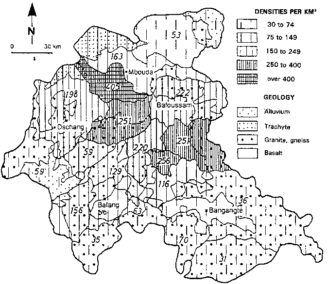
FIGURE 66 Geological map showing population distribution (cf. 1987 Census)
TRADITIONAL INTENSIVE SYSTEMS (Figure 67)
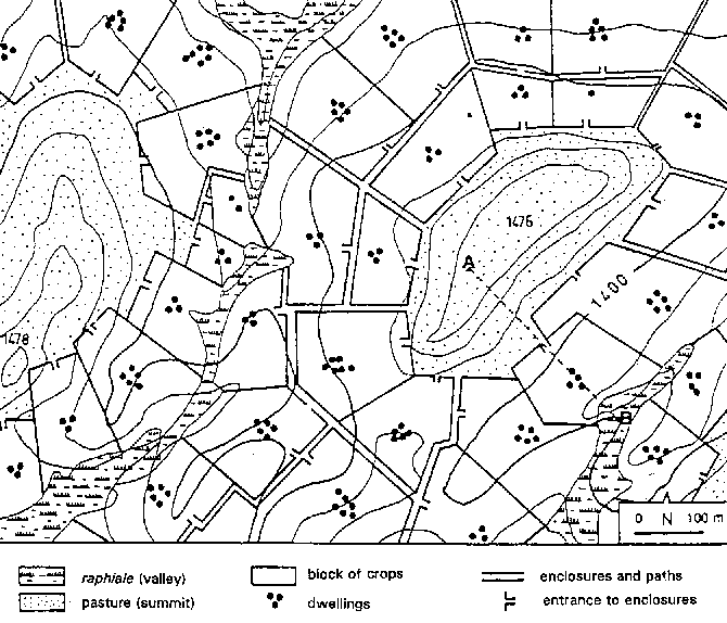
These are seen in the inhabited regions of the uplands, where family farms have three kinds of land essential for family autonomy (lowland, slope and hilltop). Intensive polyculture is combined with small animal husbandry (sheep, goats, pigs, poultry) in a bocage landscape. Family farms (generally less than 3 ha) spread down a whole slope, with a varied range of crops grown from the hilltop down to the valley.
The higher parts of the slopes are used either as pasture for sheep and goats (Pennisetum purpureum, Panicum maximum) or for food-crops (temporary or permanent) with groundnut intercropped with maize, sweet potato, beans and yam. Where density is lower, fire is used to clear land and renew fodder.
FIGURE 67 Traditional use of space (large-scale map of one section of the granite plateau)
Figure

FIGURE 68 Direction and layout of ridges on a plot
The middle sections contain houses and multi-storey multicrop gardens. In the shady coffee plantations, maize, groundnut, yautia, cassava, taro, yam, vegetables, various herbs and banana are combined with coffee, or with fruit or forest trees around the houses and pig pens. On plots kept exclusively for food crops, a second-season crop (beans, sweet potato, potato) follows the maize harvest. The generalized presence of trees - between 120 and 130 per hectare - gives the countryside a luxuriant look.
The lowlands are kept for raffia palms, Raphia farinifera, bordered by small fields of tubers (yautia, taro, yam, cassava, etc.) combined with some banana trees and various vegetables.
There are various techniques for preserving soil fertility.
• The use of a fallow period allows natural reconstitution of soil nutrients. On intensive food-crop fields there is a short fallow between cropping seasons, while groundnut fields on the hilltops are left fallow for one to two years.
• Mixed farming: plots left fallow are grazed by sheep and goats, which eat the harvest residues and leave manure. The pig pen is regularly shifted around the settlement, with the vacated space being used for crops. Manure collected from places where livestock regularly gather (piggeries, chicken coops, goat pens and small poultry enclosures at the start of the sowing season) is spread in the furrows.
• Digging in organic matter under ridges: harvest residues, livestock manure, domestic refuse, ash and any other organic matter that can enrich the soil is laid in the furrows and earthed over as the fields are being prepared. However, as not all the organic manure is transformed during the cropping season, tillage brings undecomposed matter back to the surface, and this provides partial protection for the soil.
• Recycling the biomass: this is particularly effective when ridges and furrows are alternated, with the ridges carrying the crops and the furrows receiving domestic refuse and cleared weeds which will in due course fertilize a future ridge. In this way, one part of the soil is rested and reconstituted so as to receive crops in the following season.
• Eco-burning: this consists of piling up the weeds cleared from a plot, covering them with earth, and then setting them alight through a hole in the side. The slow combustion preserves all the ash from the incineration, protects it from rainfall, and promotes soil fertilization.
Erosion control methods are similarly varied.
• Combining several crops on the same ridge: this safeguards the stability of the ridge, provides good soil cover, and reduces erosion - which explains how large ridges laid parallel with the slope effectively withstand runoff.
• Practising two cropping cycles: confined to food-crop plots, this ensures a permanent soil cover, especially when the crops from the first cycle remain partially present on the fields.
• Combination trees and crops: fruit or forest trees provide the shade needed by certain crops, curb wind speed, and maintain soil moisture. Their litter protects the soil from raindrop impact and slows down erosion.
• Keeping harvest residues on the fields: maize stubble is left standing and groundout haulms are left in furrows, thus providing a mulch for the soil and protecting it from the sun during the dry season, and from the ill-effects of runoff.
• Planting hedges to fence off the cultivated area: the "control hedges" and "closure hedges" are used to lead livestock from the vicinity of the houses up to the communal pastures on the hilltops. When reinforced horizontally with raffia ribs, they are effective in checking the flow of water and trapping suspended sediment. These forest hedges also break the wind speed. Made up of fast-growing species which can be grown from cuttings (Ficus spp., Markhamia lutea, Polyscias fulva, Harungana madagascarensis, Podocarpus milanjianus, Dracaena arborea, Hymenodycton floribundum, Datura stamonium, Veronia sp.), they are a major source of firewood, provide stakes for climbing crops, and also a secondary source of forage for small livestock.
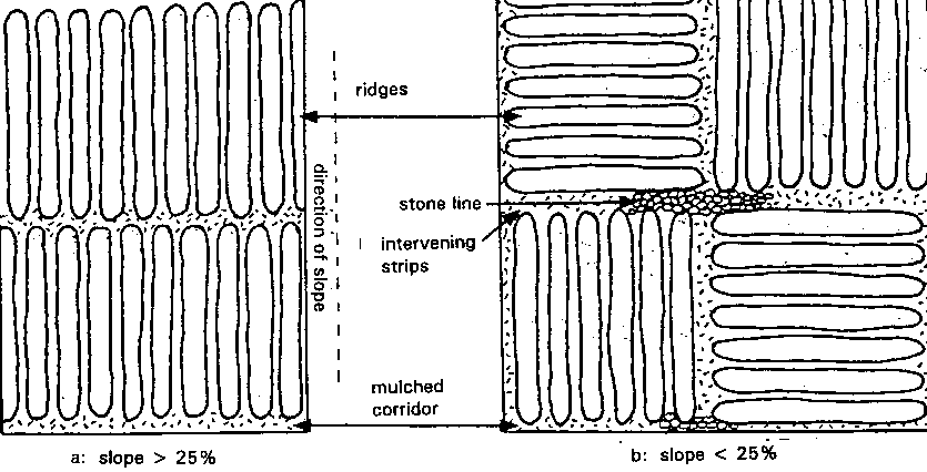
The size and layout of ridges on cultivated plots (Figure 68): this varies according to topographical position, type of crop and depth of soil (except that the length of the ridge is sometimes determined by plot size):
• on steep slopes with shallow soils, small ridges (50-70 cm wide and 20-30 cm high) are laid parallel to the steepest slope in staggered rows from the top to the bottom of the slope. The ridges are completely covered by crops, and so this arrangement is very effective in controlling runoff, channelling rainwater, cutting water velocity and reducing erosion;
• on gentle and medium slopes, large ridges (70-90 cm wide and 30-40 cm high) are laid out in a patchwork pattern, though with a slight preference for ridges parallel with the contour. Ridges parallel and perpendicular to the slope are therefore often found on the same plot.
Laying ridges parallel to the slope is well suited to the central regions where the short length of slopes, the high infiltration capacity of the soil, and continuous cropping prevent both the concentration of rainwater on the surface and fast surface flow. On the other hand, the technique is unsuitable in mountainous and granitic regions where infiltration is lower and the slope more pronounced.
USE OF LAND RESERVES AND MARGINAL LAND
Steep slopes, swampy or hydromorphic plains and mountain areas have long received little consideration from traditional development, although they have been farmed without title by Mbororo herders and indigenous farmers.
• On grazing land in mountain areas, semi-sedentary Mbororo herders raise cattle and sheep. The abundance of grass means that only a short transhumance is necessary in the dry season. Some herders practice intensive agriculture around their semi-permanent campsites, cooperating with the indigenous Bamiléké in order to take full advantage of the dung from night corrals (Fotsing 1990).
• On new farmland, farming techniques are hasty, land improvements perfunctory, and intercropping extremely simplified. Preference is given to market-garden crops (potato, onion, garlic, carrot) or food crops yielding quick returns (maize, beans), which provide scant ground cover.
This is an openfield landscape, scorched in the dry season, dotted here and there with a few fruit trees. The only wooded land is some pioneer eucalyptus rows which serve little purpose in erosion control since they are located at valley heads and on flat land where there is little risk of erosion.
RECENT CHANGES IN AGRARIAN SYSTEMS
• In intensively farmed areas, "land hunger" linked to strong population pressure leads to fragmented family farms and a shortage of space. Sons and brothers are increasingly being settled on the higher sections, and plots leased to the emigrés for secondary dwellings. In the districts of the basaltic Bafou plateau, the building density is 3.3 dwellings per hectare with an annual rate of increase of about 3%, with population density at the tolerance threshold (more than 1200 per km² Space is less crowded in the granitic area, where there has been considerable outmigration for a long time, and the annual rate of increase in building is lower (1.5%), as is the density (0.82 dwellings per ha) (Ducret and Fotsing 1987).
On constantly shrinking farms - 1.3 ha on average - market gardening simplifies the hedges and fewer trees are grown. The fallow period tends to disappear, and the use of mineral fertilizers becomes widespread for all crops. Mineral fertilizers are supplemented by off-farm livestock, particularly poultry manure. The disappearance of hilltop grazing land has reduced sheep and goat raising to penned and staked systems. The adoption of soybeans, Z 230 maize and Cardinal potatoes - varieties popularized by the UCCAO (the Central Union of Western Agricultural Cooperatives) - confirms the tendency to diversification and completes the saturation of the agrarian space.
• In the peripheral zones, the demand for farmland encourages anarchic land settlement and cropping of steep slopes. Herdsmen are driven out, dealing a fatal blow to the large livestock-rearing sector. In less than five years, new farm settlements on the Bamboutos have left livestock nothing to graze but slopes that cannot be cropped (Fotsing 1989). The rangelands still available are overgrazed and managed cyclically using strategies based on seasonal transhumance.
AREAS EXPOSED TO A VARIETY OF EROSION RISKS
Rain is the main erosive agent threatening farmland in the Bamiléké area. Erosive rain falls on poorly covered soil at an intensity of 75-120 mm/in. Cloudbursts of 150 mm/in for 15 minutes are relatively frequent (Morin 1989). They are linked to the squall lines and fall in March-April, June and October on almost bare soil (the start of the cropping season and the time of hoeing and harvesting).
At the beginning of the rainy season, rainstorms beat down on the dry and sometimes powdery surface - which is poorly protected by burnt-off plant cover or totally bare after clearing or ridging. In the middle of the rainy season, the rain beats down on weeded, waterlogged plots. Even though runoff does not start until the soil is fully saturated, it can then cause severe flooding and even landslides.
Runoff coefficients are low because of the high total porosity of the surface structures. Infiltration is 50-100 mm/in on soil of basaltic origin, and only 9-10 mm/in on granitic soil. The great depth of basaltic soils and the thick mantle of alterite they cover - sometimes over 3 m absorbs almost all rainwater, thus impeding runoff. On granitic slopes the sandy-loam texture and shallowness of the soil allow formation of a slaking crust and increased runoff. Elsewhere, the shortness of slopes due to the undulating landscape reduces the speed of surface flow and thus its erosive capacity. As soon as it accumulates, runoff spreads out in the bottom lands, marshes or subsidence basins.
TYPES OF EROSION AND DEGRADATION OBSERVED
In the western highlands, erosion depends initially on the impact of rainsplash and the presence of soils that allow runoff. However, erosivity depends largely on farming techniques.
In areas of traditional intensive polyculture, there is little erosion, the only exception being dry mechanical erosion due to the use of ridging. Nevertheless, the land at the bottom of concave slopes, which has been longest in use, is showing signs of impoverishment - a clear indication of the low level of colluvial inputs and of the extent of erosion and local leaching. Current changes also encourage the onset of runoff and erosion. The area around dwellings and the lower sides of paths and tracks are prone to rill erosion, which increases near secondary dwellings and the outlets of spillways built by the Public Works Department on public roads.
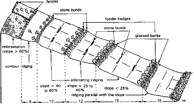
FIGURE 69 Some erosion control measures to be implemented
Continuous cropping on the same plots leads to recourse to mineral fertilizers. Chemical fertilizers (N20-P10-K10, urea and N12-P6-K20), officially meant for coffee, are diverted to food and horticultural crops. Fertilization rates are high (250-300 kg/ha on horticultural plots in the Djutitsa foothills), but nitrogen excess and potassium deficiency are observed (154N 63P 54K for coffee, 147N 72P 72K for food crops, and 427N 218P 235K for market-garden crops) (Ducret and Grangeret 1986). On the gravelly hilltops, maize is deficient in nitrogen, potassium and phosphorus. This is attributed by farmers to exhaustion of these gravelly soils which "don't hold fertilizers properly".
On higher slopes where the natural vegetation is still in place, water runs off over the carpet of grass cover with no damage to the soil, even on steep slopes. On slopes with depleted vegetation, sheet erosion gradually loosens the clumps of stubble and their roots; this is then compounded by trampling by livestock, which compacts the soil and creates the conditions for concentrated runoff. Some sand and gravel may then be carried off (Morin 1989).
On recently occupied land, slipshod farming techniques are leading to soil degradation. In the Bamboutos, repeated eco-burning is destroying the structure of topsoil over trachytes which were never very cohesive. At Baleng, on 25 % slopes tilled in ridges parallel with the slope, Olivry (1974) recorded 120 t/ha of degradation during three rainy season months. He attributes the high sediment load in runoff at Mbam throughout the rainy season to particles removed from food-crop plots in the Bamiléké country. Nevertheless, the figures are low compared with the 500 to 700 t/ha/yr recorded at Adiopodoumé under crops on sandy ferralitic soil on a 22% slope (Roose 1977a).
In conclusion, soil degradation in the Bamiléké area is inversely proportional to the intensification of cropping and the amount of plant cover at ground level, and does not depend on the slope. The situation therefore calls for a rethinking of current strategies for developing available land, taking account of the wisdom patiently accumulated by local farmers in their many years of experience.
EROSION CONTROL MEASURES (Figure 69)
Restoration of the traditional bocage system: maintaining the legal barriers and improving forage, and planting forage hedges on cultivated plots located on sloping land. Forage hedges of Leucaena, Callyandra callothyrsus or forage hibiscus, cut every three months to provide livestock fodder and to manure and mulch cultivated plots, will not reduce the arable area by much. Reinforced horizontally with raffia ribs, they will reduce water speed, halt sediment transport and control the movements of livestock. They will be planted every 15 m on slopes of under 25% (every 10 m on steeper slopes). Spacing will also have to take account of the size of family farms and the existence of livestock paddocks and fences around dwellings. Grass strips will be planted on the lower side of these fences to maximize their effectiveness in curbing sediment transport. Reconversion to the bocage system will be easier if farmers are encouraged to rear sheep.
Orientation of ridges on slopes as a function of the slope:
• on slopes of under 25%:
• small contour ridges, preferably tied, on the hilltops on shallower soil, in order to facilitate infiltration and hinder formation of runoff; care will be taken to ensure that the ridges all end at the same point to ensure a special channel for runoff;
• tied ridges in rows of six to eight ridges every 5 m, half-way down the slope on plots multicropped with coffee and foodcrops; the rows will be separated by forage hedges; a furrow between each strip, regularly mulched and broken on the downhill side by a small line of stones, will channel runoff;
• large ridges perpendicular to the slope near thalwegs on deep soils with tubers under permanent cultivation; this layout will prevent gullying in heavy rainstorms, while permanent soil cover will curb erosion;
• on slopes of over 25%:
• small tied contour ridges from the summit down to the lower third of the slope; this accounts for the physical constraints of ridging and seems more effective than simple contour ridges in breaking the force of runoff and facilitating infiltration of rainwater;
• ridges in alternating rows every 5 m toward the foot of the slope; if the soil cover is relatively thin with abundant coarse elements, ridges should not follow the slope as the soil is almost bare during the period of heavy rainstorms.
Construction of small stone lines parallel with contour lines, half-way between the hedges and preferably across the runoff routes. These lines will curb the speed of runoff and thus reduce soil erosion. The stones used are those piled by farm women to clear the plots.
Building large stone lines on the uphill side of the hedges every 10 or 15 m, using the stones and boulders that litter agricultural land in the granitic zone. These lines will reinforce erosion control structures. By curbing mechanical erosion, they will also constitute the first step in forming gradual terraces.
Light mulching on cultivated plots: uses banana or raffia leaves or twigs cut from hedges, and is necessary on plots that are not under crops during the second cropping season. It cuts evaporation and conserves soil moisture, helping plants to withstand water stress at the beginning of the cropping season. Under the shade-giving coffee bushes, it will eliminate the need for the frequent tillage that cuts the trees' roots and accelerates dry mechanical erosion.
Reforestation with eucalypts combined with annual crops on slopes between 40 and 60%. An intercropping system based on semi-shifting rotation. For the first two years after the trees are planted, the whole plot is tilled and cropped. In the third to sixth years, fallow and cropping alternate each year on different parts of the reforested area. Thinning is started in the sixth year, to pave the way for gradual renewal of the plantation. Tree size is controlled by systematically removing surface roots that can harm crops. The trees then send down tap roots that helps to maintain the stability of the slopes. Their slowly decomposing leaves act as a mulch, protecting the soil from rainsplash and maintaining soil moisture, so that only light tillage is required at the start of the cropping cycle. Plots of potato, garlic or onion grow well between eucalypts planted 5 to 8 m apart in the Bamboutos reforestation area.
Systematic reforestation with eucalypts on slopes of over 60%, with a ban on any crops that require tillage. The trees must be spaced far enough apart (3 to 4 m) to allow the development of an under-storey to protect the soil from rainsplash. Such areas can then be used as rangeland when the trees have grown to over 2 m. If the slope lies over a slide bed-plane, coppiced eucalypts felled every 5 to 7 years will gradually dry out the underlying water and stabilize the slope. This tree is also a good source of firewood and timber, and can produce a good income (Fotsing 1992c).
RESTORING SOIL FERTILITY
Rational applications of mineral supplements and the sale of appropriate fertilizers will compensate for potassium and phosphorus deficiencies. Ploughing in P and K before sowing and dressings of N during the growth period will certainly be advantageous and less expensive. (The 20 - 10 - 10 for P2O5 and K2O costs more than other products).
Improving the fallow by introducing pulses as a catch crop sown under the last crop after hoeing will hasten reconstitution of nutrients in plots being rested. If these plots are used as pasture for small ruminants they will benefit from the animal dung.
Improvement of animal husbandry methods. With small tethered livestock, this will mean shifting their stakes systematically so that the same areas are not overgrazed. With large livestock, it will mean instituting a semi-stabling system near campsites, and rotational grazing coupled with a short dry-season transhumance covering the entire range land area.
Building cisterns for better water management during the dry season. In areas with many buildings, these cisterns will collect water from roofs, watercourses and paths. This reserve of water will be used in brick-making, as a supplementary source of irrigation for vegetable gardens during the off-season - as is seen among some Bafou market-gardeners - and for stock watering. The latter will eliminate the need for herders to move their herds during the dry season, which encourages farmers to take over grazing land.
Integrated plant and animal husbandry in mountainous regions, strictly delimiting the sphere of influence of each. Dung from places where livestock is stabled will fertilize cultivated plots; while fencing a section of grazing land will foster forage regrowth. Livestock can also eat crop residues on harvested fields.
Construction of compost-manure-rubbish pits. This can become a widespread practice in populous areas, using the pits from which earth is taken for brick-making. Kitchen refuse, ash, coffee residues, brewing draff, waste from animal pens, banana stems, etc. will be piled up here and slowly decompose in the shade of the trees surrounding the houses. Refuse with a slow humification rate will be left behind, while a portion of the organic manure taken to the fields will promote the spread of market-gardening. In areas of extensive livestock production, the pits will be dug between grazing land and farm land, so that dung gathered on the range will be mixed with dried straw, constituting a major source of organic fertilizer. This technique will reduce the practice of dry-season burning, which exposes the soil to runoff and erosion.
These support measures will back up the suggested improvements, mainly the reorganization of the fertilizer market, as well as the whole supply and marketing system. This will allow generalized access to inputs and make it easier for farmers to sell their produce. Setting up "fertilizer banks" for each district and collaboration between farmers' organizations and agricultural co-operatives are also fundamental (Fotsing 1992a, b), Lastly, a general restructuring of the land-tenure system is imperative if farmers are to have the security of tenure essential for any sustainable intervention.
CONCLUSIONS Concerted
initiatives by the authorities have met with very limited
success in the face of the ever-present threat of erosion
and soil degradation in the Bamiléké area. First and
foremost, the farmers' lack of enthusiasm for the
proposed erosion control measures reveals the wide gap
between these proposals and the farmers' own approach to
land use. The processes of soil degradation now underway
are a reality that present techniques can no longer
control. On the other hand, the relatively effective
traditional techniques simply require improvement, for
they are well integrated with the environment and take
into account the central rôle of women in the
agricultural production process. The suggestions have
therefore been largely based on local know-how. If
properly applied, they will preserve the agricultural
potential of this region for a long time to come. |
Chapter 11. Agroforestry, mineral fertilization and land husbandry in Rwanda
ATTAINING FOOD SELF-SUFFICIENCY IN A HEAVILY POPULATED TROPICAL MOUNTAIN REGION
Eric Roose, Director of Soils Research, ORSTOM, Montpellier, France François Ndayizigiyé, Research Expert in Geography, ISAR, Rubona Station, Rwanda
The situation
Analysis of local conditions
Traditional techniques
Suggestions for managing surface water
Suggestions for managing soil fertility
Rwanda is a small (26000 km²) mountainous (900 to 4200 m altitude) land-locked country in Central Africa, more than 1000 km from the Indian Ocean and 2000 km from the Atlantic.
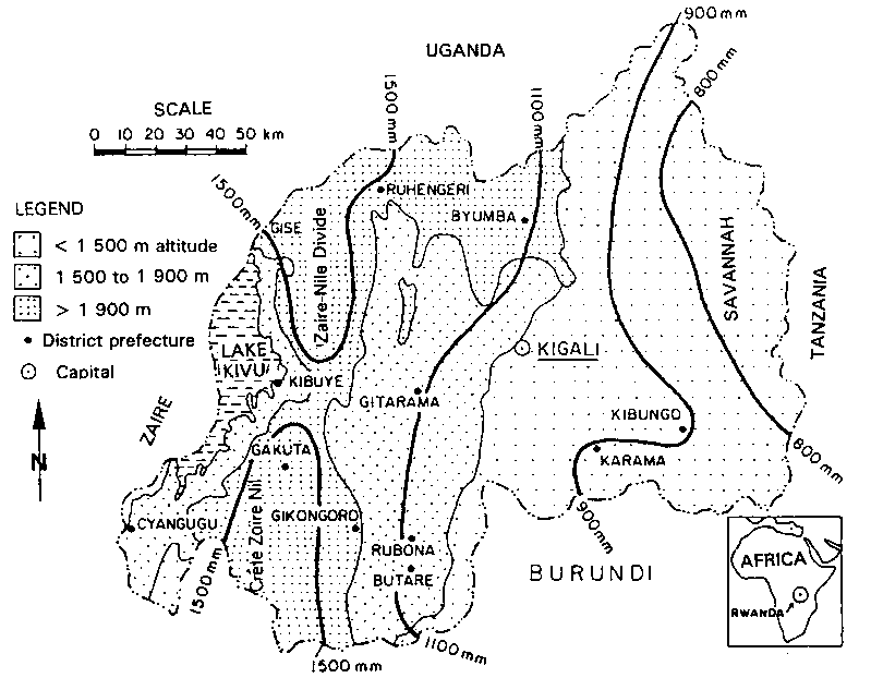
A country with a thousand hills, Rwanda has a very wide variety of landscapes. There are six major bioclimatic zones, divided according to geological bedrock, landform, population density, crops, and especially rainfall, which increases with altitude (Delepierre 1982; Gasana 1990) (see Figure 70).
The country has recently undergone massive demographic growth: its population was estimated at 1 million at the beginning of the century, 2.6 million at Independence in 1962, 8 million in 1992, and will exceed 10 million towards the year 2000. The growth rate is one of the highest in the world - 3.7%, meaning that the population doubles every 17 years. Economic growth can no longer keep up with population growth, and the farming population has fallen below the poverty threshold. As the country has virtually no more land reserves, the average size of holdings is shrinking dangerously; it is now under 0.8 ha, and more than 25% of families have to subsist on less than 0.4 ha.
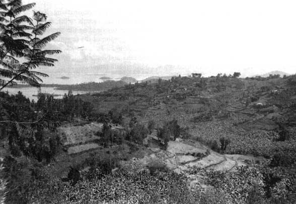
Three communities inhabit this high, tropical landscape: artisans (5%), farmers (85%) and herders (10%). The farmers - the largest group - cultivate the slopes of mid-altitude hills, while the herders occupy the hilltops during the rainy season and the lowlands during the dry season. As a result of population pressure, agriculture rapidly took over all arable land, so that the large cattle herds were forced into the eastern savannahs or the highlands (the Zaire-Nile Divide and volcanoes). Moreover, 50% of farming households today have some sheep or goats, and 30% have one or two cows. When farms are only 0.4 ha it is no longer possible to expand animal husbandry and forage crops: fallow periods have almost disappeared, and grazing is limited to roadsides and private or communal thickets. The trend is inexorably toward keeping small animals (goats, pigs, chickens) more or less permanently penned. This raises the problem of fertilizing land that was hitherto manured with cattle dung, for the reduced availability of dung means that it is no longer possible to maintain fertility on more than 30% of the land. More organic manure (from pens), more mineral supplements, and mulching will thus be needed.
FIGURE 70 Agro-environmental zones of Rwanda showing altitude (< 1500, < 1900 and > 1900 m) and rainfall (< 900, < 1500 and > 1500 mm) (cf. Delepierre 1982)
The main problem for this agricultural country (more than 90% of the population earns its living from agriculture) with scant mineral or commercial resources is that of ensuring food and wood self-sufficiency for a very large population (from 150 to over 800 per km²), without degrading this landscape of large elongated hills.
Since erosion risks vary greatly in Rwanda, the volcanic zone (one-third of the country), the areas surrounding Lake Kivu, and the Zaire-Nile Divide (where risks of landslides are greater, the steeper the slope, the more abundant the rainfall [up to 2000 mm] and the more frequent the earthquakes) have been left aside, and the results confined to those obtained on the central uplands (in the Butaré region) and in the low-lying savannah zone of the east (Karama).