The scenario control file (SCF) (b)
Back to contents - Previous file - Next file
Example 4.4: Maximize Food Production according to Preferred Pattern, Scenario F/High
To investigate the effect of an assumed adoption of a high level of inputs, scenario F is evaluated in this example at this most intensified technology level. Assuming that the land productivity database at high level of inputs is not available, the procedure to run this scenario is as follows:
Step 1: In the main menu of KENYA-AEZ, position the cursor on the fifth option (SF5), PRODUCTIVITY ASSESSMENT, and press < ENTER > .
Step 2: In the sub-menu select option one (SF1), SET DISTRICT/SCENARIO, and press < ENTER > . Specify high input, level 3, and press F5 to save the updated configuration..
Step 3: Return to the sub-menu (SF5) PRODUCTIVITY ASSESSMENT, position the cursor on the second option (SF2), CREATE PRODUCTIVITY DB, and press < ENTER > .
Step 4: Return to the main menu of KENYA-AEZ, position the cursor on the sixth option (SF6), DISTRICT ANALYSIS, and press <ENTER>.
Step 5: Select the second sub-menu item (SF2), LP MATRIX GENERATOR, and watch the processing of the land resources inventory. After completion, the LP SOLVER will start automatically.
Step 6: Select the fourth sub-menu item (SF4), LP REPORT WRITER, to produce scenario summary tables.
Step 7: Optionally, view or print the result by selecting the respective menu option (SF5) or (SF6).
TABLE 4.3 Maximize food production according to preferred consumption pattern
Land Use Statistics (Scenario F. high, input)
| ha | percent | |
| District Area | 319300 | 100.0 |
| - Urban Area | 4703 | 1.5 |
| Agriculture Land | 314597 | 98.5 |
| - Irrigated Land | 0 | .0 |
| Rainfed Land | 314597 | 98.5 |
| - Forest/Park Land | 52445 | 16.4 |
| of which used | 0 | .0 |
| - Non-Suitable Land | 38681 | 12.1 |
| - Idle Land | 0 | 0 |
| of which idle crop land | 0 | .0 |
| of which idle grassland | 0 | .0 |
| - Range Land | 70746 | 22.2 |
| - NS-Range Land | 0 | .0 |
| - Fuelwood Area | 10504 | 3.3 |
| Arable Crop Land | 145589 | 45.6 |
| - Fallow Land | 14189 | 4.4 |
| Area Harvested, primary | 131400 | 41.2 |
| Area Harvested, secondary | 100800 | |
| Area Harvested, total | 232200 | |
| Cropping Intensity | 1.767 |
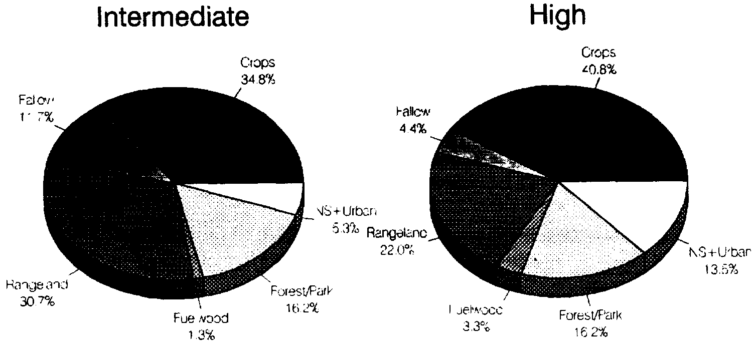
FIGURE 4.2 Optimal land use under different input levels, Bungoma District
The optimal land allocation, assuming a high input level, results in production exceeding the projected demand of year 2000 by about 30 percent in all commodity groups. It produces
some 1260 billion Kcal, enough food for about 1.5 million people at 2320 Kcal/caput/day. In addition, 330 thousand livestock units would be supported to produce the necessary meat and milk products; land for cash-crops and fuelwood production is provided for; forest/game park zones would be preserved. Table 4.3 shows the land-use statistics obtained from scenario F. at high level of inputs.
It is interesting to note that a change in input level leads not only to an overall increased production level, but also results in altered proportions of land used for different production purposes. For instance, the amount of rangeland reduces notably; this is due to more productive (feed efficient) livestock systems and increased availability of crop residues and by-products. Also, an increased share of feed supply must be provided from primary crops, e.g., feed grains. Fallow requirements are reduced under high input level; on the other hand, extents not suitable for agriculture increase because of more severe slope limitations. Figure 4.2 compares land-use by major categories under scenario F. at intermediate and high input levels.
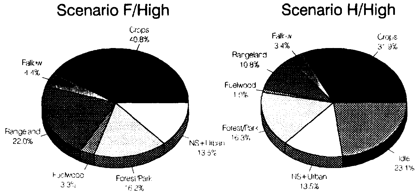
Example 4.5: Minimize Use of Arable Land, Bungoma District, Scenario H/High
The result of the previous example has shown that there is enough land, at least at high level of input, to meet projected district demand of year 2000. Then it is interesting to ask how much arable land would at least be required to produce exactly that amount. The objective becomes now to minimize the use of arable land subject to meeting district demand targets for food crops, livestock products, and fuelwood (MODE=6 of SCF); this is termed scenario H. The same constraints on cash-crop areas and livestock distribution are imposed as in the previous scenarios. Table 4.4 shows the land-use statistics from scenario H. at high level of inputs.
It turns out that under such optimal and intensified use of land resources about 113 thousand ha of arable land would be required for food and cash-crops, about 30 thousand ha of grassland, and some 3 thousand ha for intensified fuelwood production.
Setting aside land in forest/game park zones, making allowance for residential areas and infrastructure, and subtracting non-suitable land, scenario H leaves some 74 thousand ha unallocated, termed 'Idle Land' in Table 4.4. Of this, some 34 thousand ha would be suitable for some crops; the balance of 40 thousand ha could grow grass (or trees).
Figure 4.3 compares land use obtained under scenario F (maximize food production according to preferred target levels) and scenario H (minimize use of arable land subject to meeting demand targets in year 2000), both under high level of inputs.
Example 4.6: Maximize Production according to Preferred Pattern, Western Prov.
The last example in this chapter was chosen to illustrate that KENYA-AEZ can also be used to specify and analyse province level scenarios, and even conduct national analysis. For that reason, the software package contains two versions of the land resources inventory.
TABLE 4.4 Minimize use of arable land to produce district target demand
Land Use Statistics (Scenario H. High Input Level):
| ha | percent | |
| District Area | 319300 | 100.0 |
| - Urban Area | 4703 | 1.5 |
| Agriculture Land | 314597 | 98.5 |
| - Irrigated Land | 0 | .0 |
| Rainfed Land | 314597 | 98.5 |
| - Forest/Park Land | 52445 | 16.4 |
| of which used | 0 | .0 |
| - Non-Suitable Land | 33681 | 12.1 |
| - Idle Land | 74221 | 23.2 |
| of which idle crop land | 34071 | 10.7 |
| of which idle grassland | 40150 | 12.6 |
| - Range Land | 34557 | 10.8 |
| - NS-Range Land | 0 | .0 |
| - Fuelwood Area | 3155 | 1.0 |
| Arable Crop Land | 113183 | 35.4 |
| - Fallow Land | 10948 | 3.4 |
| Area Harvested. primary | 102235 | 32.0 |
| Area Harvested. secondary | 72663 | |
| Area Harvested. total . | 174898 | |
| Cropping Intensity | 1.711 |
FIGURE 4.3 Optimal land use under different scenarios, Bungoma District
Detailed LRI files, based on a 1 x 1 km² grid, are kept in directory \AEZ\KENYA\LINV\ of the installation drive; these files are intended for district analysis. A more aggregate set of LRI files, derived from a 5 x 5 km² grid, can be found in directory \AEZ\KENYA\ LINVx5\. These should be used for province level analysis or in case of district analysis if PC resources are at a premium. The appropriate data directory must be specified in configuration file SCEN.CFG in directory \AEZ\KENYA\RUN\CFG.
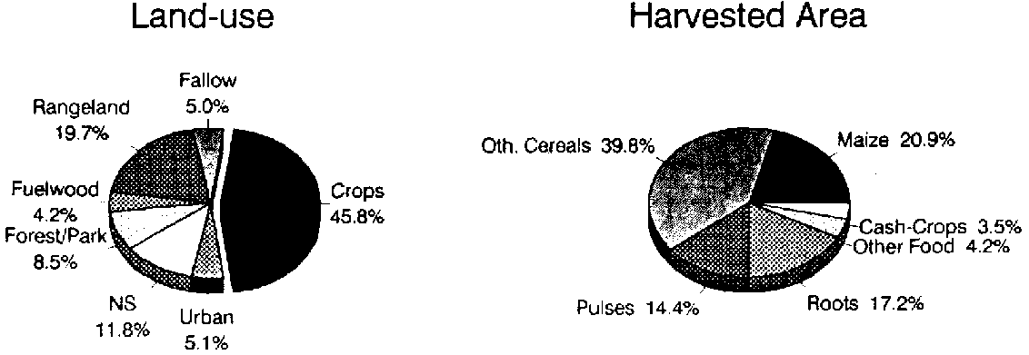
FIGURE 4.4 Optimal land use, scenario F/High, Western Province
An inventory file for Western province was obtained by concatenating the individual LRI files of Bungoma (801), Busia (802), and Kakamega (803) district. In 1979, average population density in Western province was 225 persons per square kilometre, i.e., about 2 million people in an area of 8.7 thousand km². Population is projected to increase to 4.2 million by year 2000, resulting in a density of 475 persons per km². Obviously, only an intensive agricultural system will be able to provide enough food for this population. Assumptions of scenario F were used in the example, i.e., maximizing food production in accordance with specified target levels of per caput consumption. A high level of input is assumed. Under such conditions 4170 billion Kcal of net food energy can be produced, some 32 percent in excess of the projected minimum requirement. Agriculture, including food crops, cash-crops, pastures and fuelwood production, would account for 75 percent of land use. Maize and rice would be the dominating crops. About 540 thousand livestock units (TLU) would need to be supported to provide sufficient meat and milk. Figure 4.4 illustrates the optimal structure of land-use and harvested area in Western province according to scenario F assumptions.
Many other scenarios could be constructed for Western province, relating to demographic development, economic criteria, environmental impacts, altered demand preferences, etc. The user of KENYA-AEZ is encouraged to explore the database and experiment with the system.