Back to contents - Previous file - Next file
The scenario control file (SCF) (a)
The scenario control file (SCF) (b)
In this chapter several district planning scenarios are discussed to indicate the kind of quantitative analysis that can be addressed with the KENYA-AEZ system. As pointed out earlier, the system has a considerable history of development. It should not been seen as a frozen black box but as a tool that is gradually revised as additional data become available and new tasks are formulated. Bungoma district in Western province of Kenya serves as an illustrative case in the following examples.
Bungoma district is situated on the slopes and foothills of Mt. Elgon bordering Uganda. The district enjoys good soils and generally abundant and well distributed annual average rainfall of 1000-1800 mm, depending on location. The length of the total growing season exceeds 270 days in practically all of the district, allowing for multiple cropping patterns. Altitude of agricultural areas ranges from about 1300 m (thermal zone 3; 20.0-22.5° Celsius) in the southern part of Bungoma to about 3500 m (thermal zone 8; 5.0-10.0° Celsius) on the slopes of Mt. Elgon in the North of the district. Presently grown cereal crops include maize, wheat, barley and finger millet. There is good potential for beans and potatoes. In addition, several cash crops like coffee, tea, cotton, pyrethrum and sugar cane can be cultivated.
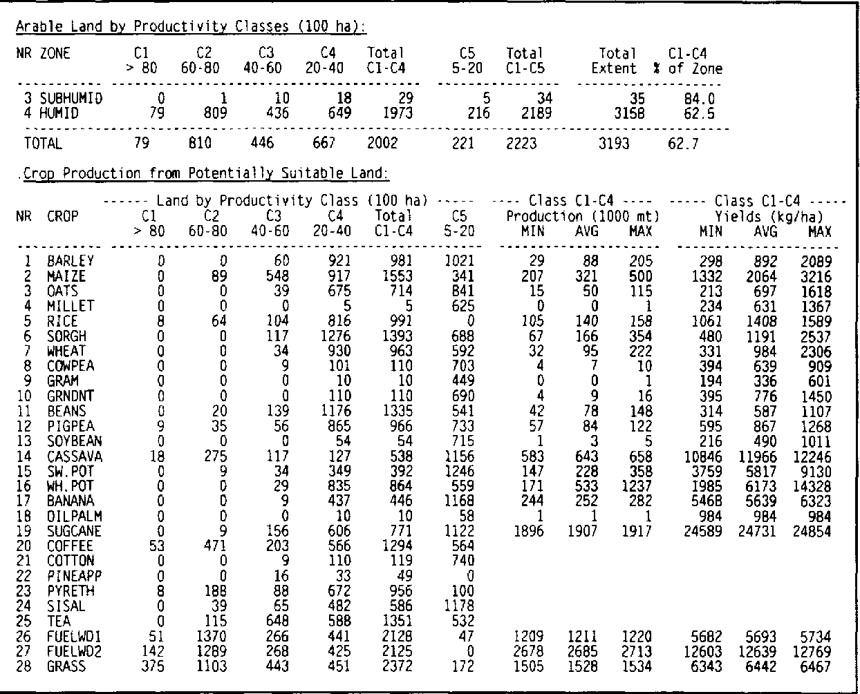
Table 4.1 summarizes the AEZ assessment of potentially arable land in Bungoma district and shows the maximum suitable extents by crop. About 200 thousand ha, i.e. over 60 percent of the entire district, is considered potentially arable. About 1/3 of this area is of only marginal quality. Maize, sorghum and beans are suitable on much of the potentially arable land. Cassava and potatoes could provide significant amounts of food energy. The assessment also asserts good potential for cash-crops like coffee, tea and pyrethrum.
In the 1979 census, the recorded population in Bungoma district slightly exceeded 0.5 million people. It is projected to increase to almost 1.3 million in year 2000. As a result, potentially arable land reduces from 0.4 ha/person in 1980 to 0.15 ha/person in year 2000. In the past, the growing population density has lead to increased fragmentation of holdings. Despite of generally favorable conditions the district is facing increased pressure on its resource base and, as the following examples will show, enhanced intensification of agricultural production will be required to secure future food supplies and adequate incomes.
TABLE 4.1 Potentially arable land, Bungoma District
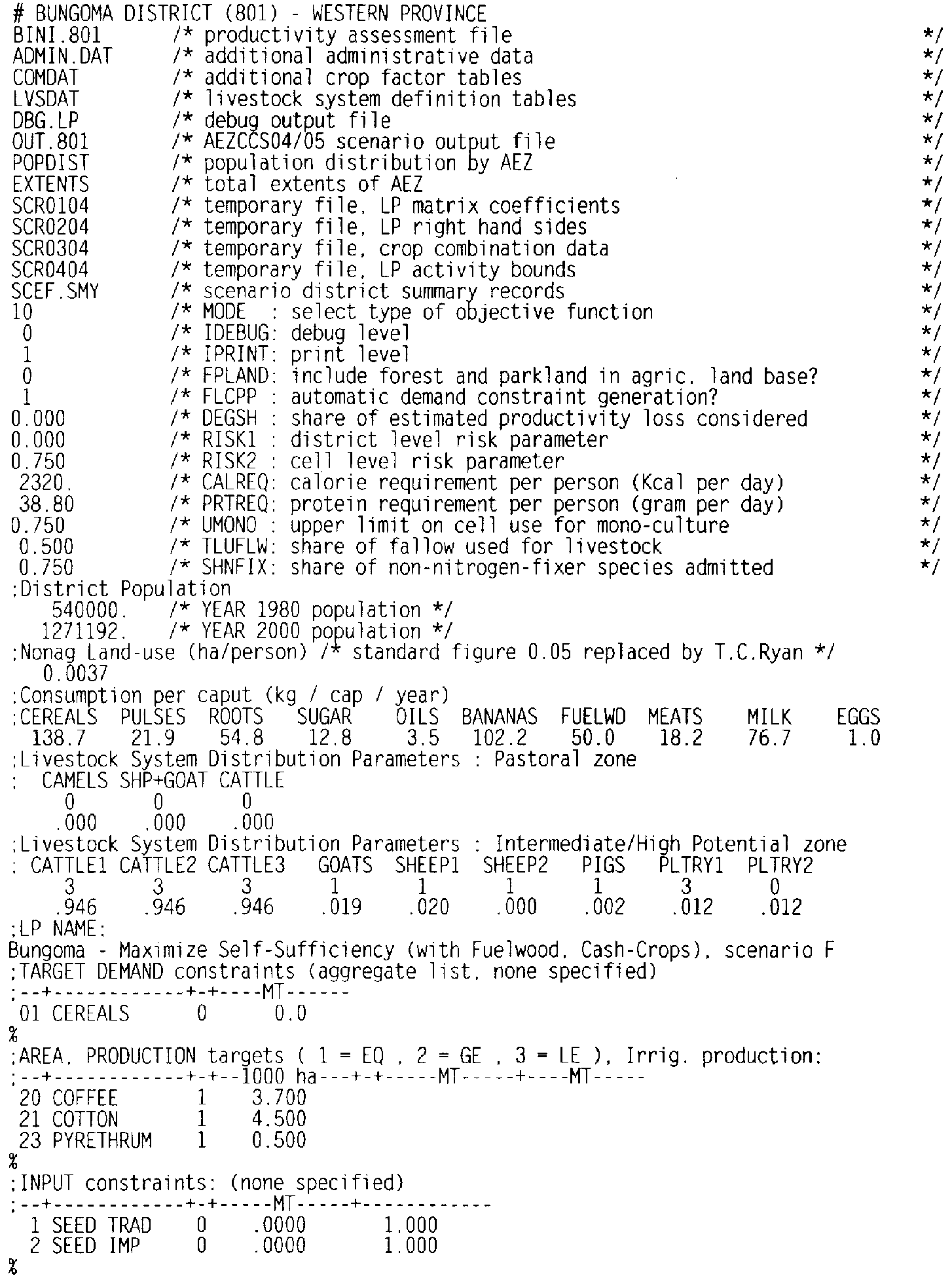
Each program of the Kenya-AEZ system package is controlled by a short input data file. Example 4.1 shows a simple version of the LP control data file for Bungoma district, to optimize land use for maximum food production at intermediate level of inputs, subject to meeting food preferences as expressed by per caput demand targets, and allowing production targets for cash-crops (coffee, cotton, pyrethrum). The LP program is run by using option SF6) DISTRICT ANALYSIS of the main menu. This control file is used both by the LP matrix generator program option (SF2) within option (SF6) as also the LP report writer option (SF4) within option (SF6). In the example, land marked as belonging to forest zones or game parks is excluded from the analysis or restricted in use. Distribution of livestock systems is controlled by equality and inequality constraints on the share that each system takes up in the total number of supported livestock units. For further details see FAO/IIASA (1991, Technical Annex 7).
Example 4.1: Scenario Control File, Bungoma District
Example 4.2: Potential Population Supporting Capacity, Bungoma, District Scenario A
Population supporting capacity, as defined here, relates to the maximum potential of soil and climatic resources to produce food energy and protein, at a given level of technology. This first example is not concerned how this potential or the stipulated level of technology can be realized, nor does it consider production activities outside agriculture that could provide income for exchange of goods and food. So, population supporting capacity as used here is neither a dynamic concept nor does it include indirect sources of population support. The question is simply how much food can be produced on the potentially suitable land under optimal resource use? In order to compare this potential to the projected year 2000 population level, an intermediate level of inputs is assumed. Production is maximized in terms of energy content available for human consumption (MODE= 1 in the Scenario Control File), i.e., after subtracting appropriate amounts for conversion to food products and for wastage. All potentially suitable land can be considered in the optimization, including forest and game parks (FPLAND=3 in the Scenario Control File). Minimum food requirements are set at 2320 Kcal/caput/day and 38.8 g protein/caput/day. An LP constraint on human calorie/protein requirements is used to ensure sufficient protein production. The resulting commodity bundle is not constrained in this example, which is called scenario A. The scenario is processed on the computer as follows:
Step 1: In the main menu of KENYA-AEZ, position the cursor on the sixth option (SF6), DISTRICT ANALYSIS, and press <ENTER>.
Step 2: In the sub-menu which is displayed, select option one (SF1), SET DISTRICT/SCENARIO, and press c ENTER > .
Step 3: The currently selected district, input level and scenario will be shown. If necessary change the setting to: province 8 (Western province), district 1 (Bungoma), input level 2 (intermediate), scenario A. This is the default setting of the demonstration version of the software, which is supplied with the User Manual. Press F5 to return to the district analysis sub-menu.
Step 4: Select the second menu item (SF2), LP MATRIX GENERATOR, and watch the processing of the land resources inventory. After completion, the LP SOLVER will start automatically.
Step 5: Select the fourth menu item (SF4), LP REPORT WRITER, to produce scenario summary tables.
Step 6: Optionally, view or print the result by selecting the respective menu option (SF5) or (SF6).
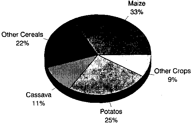
With the assumptions stated above, the assessment results in food production of about 1400 billion Kcal: At the stated minimum requirement of 2320 Kcal/caput/day, some 1.7 million people can be supported, i.e., about 30 percent more than projected for year 2000. The food maximizing production pattern would be largely based on cereals and root crops, respectively 110 kg and 350 kg per person annually, and with additional protein from livestock products, with per caput consumption levels of about 50 kg milk and 2.2 kg meat per year. Maize would account for one third of total harvested area, potatoes for some 25 percent.
FIGURE 4.1 Harvested area under maximum food production, Bungoma District
Figure 4.1 presents the distribution of harvested area obtained from optimal land allocation in scenario A.
Example 4.3: Maximize Food Production according to Preferred Pattern, Scenario F/Int
Although changing the consumption pattern could be an effective adaptation strategy to meet rising food demands, this second scenario example asks what the supported population number would be if: (a) forest zones and game parks were left untouched by agriculturalists (FPLAND=0 in SCF), and (b) the produced commodity bundle was forced to match past per caput consumption patterns of Western province (FLCPP= 1 in SCF). The target consumption levels per caput per year in scenario F are set at 139 kg cereals, 55 kg roots and tubers, 13 kg sugar, 50 kg bananas, 18 kg meat and 77 kg milk. The distribution of livestock units should follow observed patterns, i.e., almost 95 percent cattle, 2 percent each from sheep and goats, the remaining 1 percent from pigs and poultry. The objective in this scenario is specified as maximizing the joint fulfillment (self sufficiency ratio, SSR) of projected demand (MODE= 10 in SCF). The scenario is evaluated at the intermediate level of inputs. To run this scenario, the procedure is similar to the previous example:
Step 1: In the main menu of KENYA-AEZ, position the cursor on the sixth option (SF6), DISTRICT ANALYSIS, and press <ENTER>.
Step 2: In the sub-menu which is displayed, select option one (SF1), SET DISTRICT/SCENARIO, and press < ENTER > .
Step 3: Change scenario to F. Press F5 to return to the district analysis sub-menu.
Step 4: Select the second menu item (SF2), LP MATRIX GENERATOR, and watch the processing of the land resources inventory. After completion, the LP SOLVER will start automatically.
Step 5: Select the fourth menu item (SF4), LP REPORT WRITER, to produce scenario summary tables.
Step 6: Optionally, view or print the result by selecting the respective menu option (SF5) or (SF6).
TABLE 4.2 Maximize food production according to preferred consumption pattern
Final Product Supply :
| COMMODITY | Supply | Prim. Feed | Net Supply | Target | % SSR |
| 1 CEREALS | 141443 | 10264 | 131178 | 176314 | 74.4 |
| 2 PULSES | 20713 | 0 | 20713 | 27839 | 74.4 |
| 3 ROOTS | 120248 | 68418 | 51830 | 69661 | 74.4 |
| 4 SUGAR | 12106 | 0 | 12106 | 16271 | 74.4 |
| 5 OILS | 0 | 0 | 0 | 4449 | .0 |
| 6 BANANAS | 48330 | 0 | 48330 | 129916 | 37.21 |
| 7 FUELWD | 47290 | 0 | 47290 | 63560 | 74.4 |
| 8 MEAT | 17214 | 0 | 17214 | 23136 | 74.4 |
| 9 MILK | 72542 | 0 | 72542 | 97500 | 74.4 |
| 10 EGGS | 946 | 0 | 946 | 1271 | 74.4 |
Land Use Statistics (Scenario F. intermediate input):
| ha | percent | |
| District Area | 319300 | 100.0 |
| - Urban Area | 4703 | 1.5 |
| Agriculture Land | 314597 | 98.5 |
| - Irrigated Land | 0 | .0 |
| Rainfed Land | 314597 | 98.5 |
| - Forest/Park Land | 52445 | 16.4 |
| of which used | 0 | .0 |
| - Non-Suitable Land | 12297 | 3.9 |
| - Idle Land | 0 | .0 |
| of which idle crop land | 0 | .0 |
| of which idle grassland | 0 | .0 |
| - Range Land | 99086 | 31.0 |
| - NS-Range Land | 0 | .0 |
| - Fuelwood Area | 4126 | 1.3 |
| Arable Crop Land | 149570 | 46.8 |
| - Fallow Land | 37519 | 11.8 |
| Area Harvested, primary | 112051 | 35.1 |
| Area Harvested, secondary | 95697 | |
| Area Harvested, total | 207748 | |
| Cropping Intensity | 1.854 |
1 Banana is the only fruit commodity represented in the AEZ assessment; banana is assumed to account for about half the fruit consumption in Bungoma.
Table 4.2 shows aggregate production levels and statistics on land-use that result from scenario F. It indicates that under the assumption of intermediate level of inputs not more than 3/4 of the projected year 2000 commodity demand can be met the resource base of Bungoma district.
These results suggest that intensification of agricultural production is essential to meeting the projected district demand for crops, livestock products and fuelwood. The quality of the soil and climatic resources in Bungoma would certainly allow for such intensification; the demographic and socio-economic development, on the other hand, may hinder adoption of high input technologies.