GEOGRAPHY, POPULATION AND WATER RESOURCES
Botswana is a semi-arid, landlocked country in the centre of Southern Africa, with a total area of 581 730 km². It is one of the Southern African Development Community (SADC) partners. There is about 6.2 million ha of cultivable land, which is 10% of the total area. Cultivated land was 324 200 ha in 1990 (down from 382 300 ha in 1987), comprising 284 000 ha of smallholdings on communal land and 40 200 ha of commercial farms. Crop yields are often unsatisfactory due to rainfall failure and/or damage from livestock or game.
Total population is about 1.4 million (1994). According to the 1991 census, 21 % is urban, 22% lives in major villages (small towns) and 57% is in rural villages and other settlements.
Average population density is 2.5/km². Annual population growth is estimated to be 3.4%. Agriculture - crop production and livestock - contributes approximately 4% to GDP, although they provide occupation for more than 70% of the population.
Climate and water resources
The mean annual rainfall is 400 mm, ranging from 250 mm in the southwest to a maximum of 650 mm/year in the extreme north. Over 90% of the rainfall occurs during summer (November to March), mainly as scattered convective thunderstorms. Hail storms are common at the beginning and end of the rainy season. Distribution of rainfall is extremely variable, with lengthy dry spells. Drought years are common, but rainfall tends to be more reliable in the north.
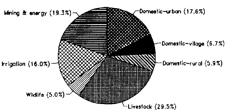
The total mean annual surface runoff from catchments emanating within Botswana is about 1.2 km³/year, of which about 60% comes from the contributory catchment of the Limpopo. The remainder is in the Makgadikgadi pans. In addition to the internally generated surface water resources, Botswana receives an estimated 11.5 km³/year from the Angolan Plateau, through Namibia, most of which disappears in the Okavango swamp delta, and about 0.3 km³/year is bordering. The groundwater potential in the country is estimated to be 1.7 km³/year but the extractable volume is only about 1 km³/year. Average recharge is estimated to be 3 mm/year, ranging from 40 mm in the north to zero in the west of the country. Total water abstraction in 1990 was 76 million m³ from some 15 000 tubewells, and is forecast to rise to 140 million m³ annually by the year 2020 (Figure 1). Saline water has been found in Maun Region. A pilot farm has been established for water re-use from Gaborone. In 1990, return flows were 10.5 million m³ and are expected to rise to 64.4 million m³/year in 2020.
TABLE 1
Basic statistics and population
| Area of the country | 1994 | 58 173 000 ha |
| Cultivable land | 1994 | 6 200 000 ha |
| Cultivated land | 1990 | 324 200 ha |
| Total population | 1994 | 1 443 000 inhab. |
| Population density | 1994 | 2 inhab./km² |
| Rural population | 1991 | 79 % |
| Water supply coverage | ||
| Urban population | 1994 | 100 % |
| Rural population | 1994 | 39 % |
TABLE 2
Water balance
| Water resources: | |||
| Average precipitation | 401 | mm/yr | |
| 233.2 | km³/yr | ||
| Internal renewable water resources - total | 2.9 | km³/yr | |
| Internal renewable water resources - per caput | 1994 | 2 010 | m³/yr |
| Global renewable water resources | 14.7 | km³/yr | |
| Dependency ratio | 80.3 | % | |
| Total dam capacity | 1992 | 0.4 | km³ |
| De-salinated water | 10 6 m³/yr | ||
| Water withdrawal: | |||
| - Agricultural | 1992 | 54 | 10 6 m³/yr |
| - Domestic | 1992 | 36 | 10 6 m³/yr |
| - Industrial | 1992 | 23 | 10 6 m³/yr |
| Total | 113 | 10 6 m³/yr | |
| per caput | 1992 | 85 | m³/yr |
| as % of internal renewable water resources | 3 9 | % | |
| Other withdrawal | 1992 | 6 | 10 6 m³/yr |
| Wastewater: | |||
| Produced | 1990 | 10 5 | 10 6 m³/yr |
| Treated | 1994 | 0 | 10 6 m³/yr |
| Re-used treated wastewater | 10 6 m³/yr |
TABLE 3
Irrigation and drainage
| Irrigation potential | 1992 | 20 216 | ha |
| Irrigation: | |||
| 1. Full or partial control Irrigation: equipped area | 1992 | 1 381 | ha |
| - surface irrigation | 1992 | 218 | ha |
| - sprinkler irrigation | 1992 | 892 | ha |
| - micro-irrigation | 1992 | 271 | ha |
| % of area irrigated from groundwater | 1992 | 44.3 | % |
| % of area irrigated from surface water | 1992 | 55.7 | % |
| % of equipped area actually irrigated | 1992 | 100 | % |
| 2. Spate irrigation area | - | ha | |
| 3. Equipped wetland and inland valley bottoms | - | ha | |
| 4. Other cultivated wetland and inland valley bottoms | - | ha | |
| 5. Flood recession cropping area | 1992 | 6 500 | ha |
| Total water managed area (1 +2+3+4+5) | 1992 | 7 881 | ha |
| - as a % of cultivated area | 1992 | 2.4 | % |
| - increase over last 10 years | - | % | |
| - power irrigated area as % of water managed area | 1992 | 14.2 | % |
| Full or partial control schemes: | Criteria | ||
| Large schemes | > - ha | - | ha |
| Medium schemes | - | ha | |
| Small schemes | < - ha | - | ha |
| Total number of households in irrigation | |||
| Irrigated crops: | |||
| Total irrigated grain production | 1991 | 1 400 | t |
| as % of total grain production | 1991 | 2.6 | % |
| Harvested crops under irrigation (full or partial control) | 1991 | 1 381 | ha |
| - vegetables | 1991 | 431 | ha |
| - maize | 1991 | 350 | ha |
| - pasture and fodder | 1991 | 220 | ha |
| - citrus and other fruits | 1991 | 180 | ha |
| - other | 1991 | 200 | ha |
| Drainage - Environment: | |||
| Drained area | - | ha | |
| as % of cultivated area | - | % | |
| Flood-protected area | - | ha | |
| Area salinized by irrigation | - | ha |
IRRIGATION DEVELOPMENT
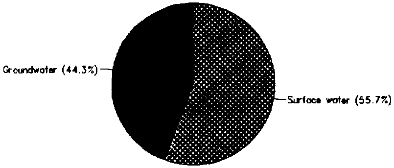
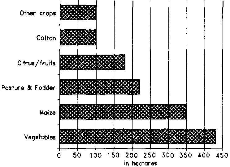
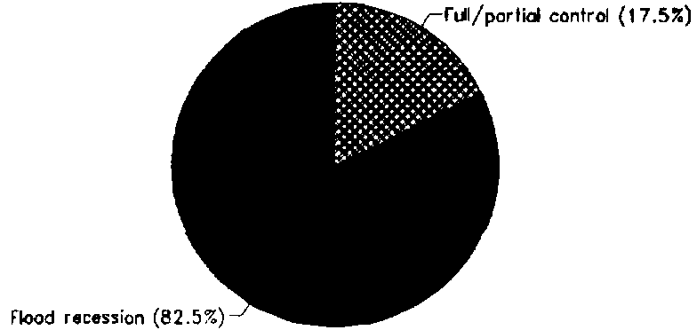
Total irrigation potential has been estimated at 39 300 ha, but, taking into account the water availability, it drops to about 20 000 ha, including flood recession cropping. The Total water managed area is 7 881 ha, or 39% of the irrigation potential. Full or partial water control is provided on 1 381 ha, which is only 17% of the total water managed area. Of this, 612 ha (44%) is irrigated from groundwater and 769 ha (56%) from surface water, either by pumping from the Limpopo and other rivers or from storage reservoirs (Figure 2). The major irrigated crops are vegetables, maize, pasture and fodder crops, citrus and cotton (Figure 3). There are some 6 500 ha of flood recession cropping - molapo - around the Okavango and Chobe enclave, on which mostly maize and millet are planted (Figure 4).
FIGURE 1: Water withdrawal (total: 0.11 km³ in 1992)
FIGURE 2: Origin of irrigation water, full and partial control (1992)
FIGURE 3: Irrigated crop areas under full or partial control (1989/90 season)
FIGURE 4: Distribution of the water managed areas (1992)
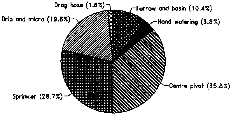
Full and partial control irrigation techniques include 218 ha surface irrigation (53 ha hand watering; 143 ha furrow and basin; and 22 ha drag hose) and 1 163 ha under overhead irrigation (495 ha centre pivot; 397 ha sprinkler; and 271 ha under drip and micro-sprinkler) (Figure 5).
Future irrigation development is likely to be only on a very limited scale (2 335 ha), the main constraint being shortage of water and its high opportunity cost. There is also some potential for further development of the traditional molapo recession-cropping to as much as 10 000 ha.
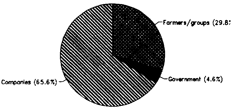
There are four categories of farming in the Irrigation Subsector (Figure 6):
There are no irrigation water charges at present. The Ministry of Mineral Resources and Water Affairs has indicated that, in the future, government could provide dams and headworks while irrigation water users should cover the distribution costs.
FIGURE 5: Irrigation management, full or partial control (1992)
FIGURE 6: Irrigation techniques, full or partial control (1992)
INSTITUTIONAL ENVIRONMENT
Responsibility for planning and implementation of irrigation development rests with the Ministry of Agriculture. The Director of Water Affairs is Registrar of the Water Apportionment Board, provides the Secretariat and acts as Technical Adviser to the Board. The Water Act and the Borehole Act, administered by the Board, require individuals or groups to apply for a right to use irrigation water.
TRENDS IN WATER RESOURCES MANAGEMENT
Botswana accepts that food self-sufficiency is neither achievable nor sustainable. Its objectives are therefore to improve food security at both household and national levels by giving top priority to production systems and programmes which are sustainable, efficient in resources and environmentally compatible. Any proposed irrigation project must be shown to be economically viable and sustainable. Botswana faces a substantial shortfall in water supplies as competing uses and consequent high opportunity cost of water makes it uneconomic for irrigation. Any further large-scale irrigation is therefore doubtful.
Small-scale irrigation, growing high-value food crops for local markets, is taking place spontaneously under market forces, without promotion from Government. Such small-scale commercial farmers obtain their water supplies from wells and boreholes (as well as surface water in group schemes), for which there is government support in the form of grants under the Financial Assistance Policy.
There is also potential for further development of the traditional recession irrigation - molapo -farming, up to as much as 10 000 ha.
The National Water Master Plan considered the economics of water use for irrigation based on three scenarios, requiring progressively higher levels of government support from zero up to provision of free water, so as to achieve 20% of national grain requirements by 2020. Hence the area developed under irrigation over the next two decades will depend upon what the government can afford.
MAIN SOURCES OF INFORMATION
FAO. 1991. Irrigation subsector review: Prospects and constraints. Report prepared by C. Chapman for project FAO TCP/BOT/0051, Assistance in irrigation development. Rome.
FAO. 1994. Project Findings and Recommendations. Terminal Report of UNDP/FAO project BOT/86/010, Water conservation facilities and irrigation development. Rome.
Gieske, A., & Gould, J. (eds) 1994. Proceedings of the Integrated Water Resources Management Workshop 1994. Kanye, Gaborone, 17-18 March 1994. Published by the Dept. of Environmental Science and Geology, Univ. of Botswana, Gaborone, with SIDA funding.
Ministry of Mineral Resources and Water Affairs, Department of Water Affairs. 1992. Botswana National Water Plan Study. Prepared by SMEC/KPB/SGAB.
SADCC [Southern African Development Coordination Conference]/AIDAB [Australian International Development Assistance Bureau]. 1992. Regional Irrigation Development Strategy. Country Report: Botswana. Harare.
VIAK. 1987. Small dams construction. Report prepared for project BOT/85/C01.