GEOGRAPHY, POPULATION AND WATER RESOURCES
Egypt lies in the northeastern corner of the African continent, with a total area of about 1 million km² In 1993, cultivated land was estimated to be 3.2 million ha, or 3.2% of the total area.
Total population is about 62 million (1994), of which 56% is rural, with annual demographic growth estimated at 2.3%. Average population density is 62/km², but ranges from 2/km² over 96% of the total area, to 1 492/km² in the Nile valley and delta. This area, where population density is among the highest in the world, is only 4% of the total area.
TABLE 1
Basic statistics and population
| Total area | 1994 | 100 145 000 ha |
| Cultivable land | - ha | |
| Cultivated land | 1994 | 3 246 000 ha |
| Total population | 1994 | 61 636 000 inhab. |
| Population density | 1994 | 62 inhab./km² |
| Rural population | 1993 | 56 % |
| Water supply coverage | ||
| Urban population | 1990 | 95 % |
| Rural population | 1990 | 86 % |
In 1990, agriculture accounted for 18% of Egypt's GDP, and 20% of its export earnings. It provided employment to 41 % of the labour force.
Climate and water resources
The mean annual rainfall of 18 mm ranges from 0 mm/year in the desert to 200 mm/year in the north coastal region.
The Nile river is the main source of water for Egypt. Under the 1959 Nile Waters Agreement, Egypt's share is 55.5 km³/year The 1959 Agreement was based on the average flow of the Nile during the 1900-1959 period, which was 84 km³/year at Aswan. The average annual evaporation and other losses from the High Dam lake were estimated to be 10 km³/year leaving a net usable annual flow of 74 km³/year of which 18.5 km³/year was allocated to Sudan and 55.5 km³/year to Egypt.
The volume of groundwater entering the country on an annual basis from Sudan is estimated at 1 km³ The main source of internal recharge is percolation from irrigation water, and its quality depends mainly on the quality of the irrigation water. In the northern part of the Delta, groundwater becomes brackish to saline due to seawater intrusion. About half of the Delta contains brackish to saline groundwater. The Nubian sandstone aquifer, located under the Western Desert and extending to Libya and Sudan, contains important non-renewable fresh groundwater resources, already developed in the oasis of the new valley. Large irrigation schemes pumping water from the Nubian aquifer are under development in the southwestern part of the country (Al Aweinat).
TABLE 2
Water balance
| Water resources: | |||
| Average precipitation | 18 | mm/yr | |
| 18.1 | km³/yr | ||
| Internal renewable water resources - total | 1.8 | km³/yr | |
| Internal renewable water resources - per caput | 1994 | 29 | m³/yr |
| Global renewable water resources | 68.5 | km³/yr | |
| Dependency ratio | 97.5 | % | |
| Total dam capacity | 1994 | 169 | km³ |
| De-salinated water | 1990 | 25 | 10 6 m³/yr |
| Water withdrawal: | |||
| - Agricultural | 1993 | 45 400 | 10 6 m³/yr |
| - Domestic | 1993 | 3 100 | 10 6 m³/yr |
| - Industrial | 1993 | 4600 | 10 6 m³/yr |
| Total | 10 6 m³/yr | ||
| per caput | 1993 | 880 | m³/yr |
| as a % of internal renewable water resources | 2 950 | % | |
| Other withdrawal | 1993 | 1 800 | 10 6 m³/yr |
| Wastewater: | |||
| Produced | 1993 | 3 430 | 10 6 m³/yr |
| Treated | - | 10 6 m³/yr | |
| Re-used treated wastewater | 1993 | 200 | 10 6 m³/yr |
TABLE 3
Irrigation and drainage
| Irrigation potential | 1993 | 4 434 000 | ha |
| Irrigation: | |||
| 1. Full or partial control Irrigation: equipped area | 1993 | 3 246 000 | ha |
| - surface irrigation | 1993 | 2 830 000 | ha |
| - sprinkler irrigation | 1993 | 312 000 | ha |
| - micro-irrigation | 1993 | 104 000 | ha |
| % of area irrigated from groundwater | 1993 | 4.5 | % |
| % of area irrigated from surface water | 1993 | 95.5 | % |
| % of equipped area actually irrigated | 1993 | 100 | % |
| 2. Spate irrigation area | - | ha | |
| 3. Equipped wetland and inland valley bottoms | - | ha | |
| 4. Other cultivated wetland and inland valley bottoms | - | ha | |
| 5. Flood recession cropping area | - | ha | |
| Total water managed area (1 +2+3+4+5) | 1993 | 3 246 000 | ha |
| - as % of cultivated area | 1993 | 100 | 96 |
| - increase over last 10 years | - | % | |
| - power irrigated area as % of water managed area | 1993 | 95 | % |
| Full or partial control schemes: | Criteria | ||
| Large schemes | > - ha | - | ha |
| Medium schemes | - | ha | |
| Small schemes | < - ha | - | ha |
| Total number of households in irrigation | |||
| Irrigated crops: | |||
| Total irrigated grain production | - | t | |
| as a % of total grain production | 100 | % | |
| Harvested crops under irrigation | 1993 | 4 820 000 | ha |
| - berseem | 1993 | 1 082 000 | ha |
| - wheat | 1993 | 894 000 | ha |
| - maize | 1993 | 804 000 | ha |
| - rice | 1993 | 538 000 | ha |
| - other | 1993 | 1 502 000 | ha |
| Drainage - Environment: | |||
| Drained area | 1993 | 2 931 000 | ha |
| as a % of cultivated area | 1993 | 90 | % |
| Flood-protected area | - | ha | |
| Area salinized by irrigation | 1972 | 1 210 000 | ha |
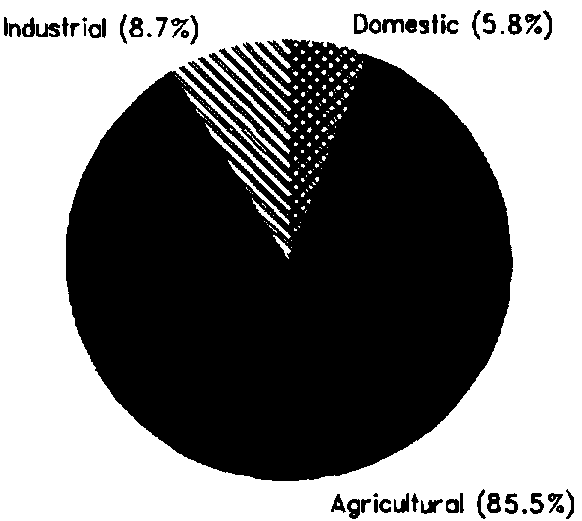
Total annual water withdrawal was estimated at 53.1 km³ in 1993 (Figure 1). This amount does not include an annual estimated loss of 2 km³/year due to evaporation from 31 000 km of canals, nor the annual water requirement for navigation, estimated at 1.X km³ in 1993.
Re-used treated wastewater is estimated at 0.2 km³/year In 1986, irrigation from reused treated wastewater was about 4 200 ha.
IRRIGATION DEVELOPMENT
Almost all agriculture in Egypt is irrigated agriculture. Even the small, more humid area along the mediterranean coast requires supplementary irrigation to produce reasonable yields. The Total water managed area is 3 246 000 ha, of which more than 90% is in the Nile valley and delta. Taking into consideration the fact that 1 189 000 ha are planned to be reclaimed before the year 2000, the total potential for irrigation development can be estimated as 4 434 000 ha.
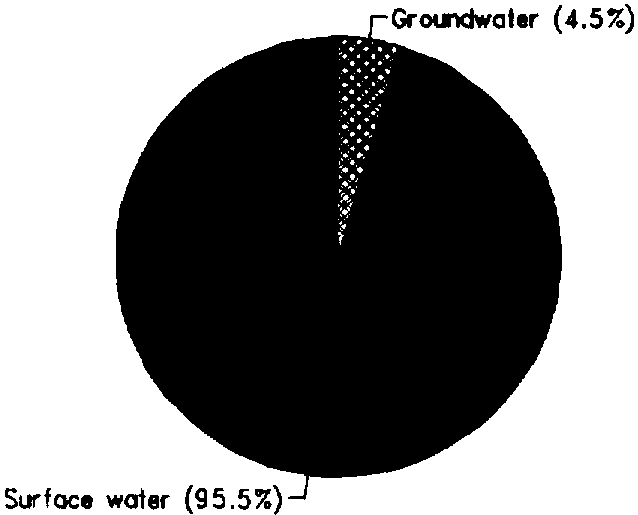
All irrigation is full or partial control irrigation. All lands are irrigated from the Nile, except in the provinces of Matrouh, Sinai and New valley, where 146 000 ha is irrigated from groundwater (Figure 2).
The irrigation system in the old lands of the Nile valley is a combined gravity and water lifting system. The main canal system (first level) takes its water from head regulators, located upstream of the Nile dams. Water is distributed along branches (second level) where the flow is continuous. At the third level, distributaries receive water according to a rotation schedule. Water is pumped from these to irrigate the fields (about 0.5 m of lift).
The irrigation system in the new lands (reclaimed areas) is based on a succession of pumping stations from the main canal to the fields, with a total lift of between 20 and 30 m.
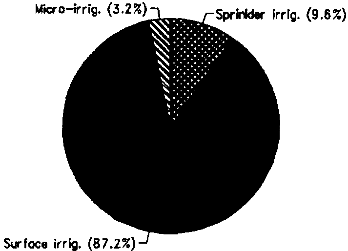
In the new reclaimed areas, farmers use sprinkler or drip irrigation. Surface irrigation techniques are there banned by law. The main reason for this ban is that these areas, located at the end of the systems, are more subject to water shortages and that most of the new reclaimed lands are sandy soils. Sprinkler and drip irrigation need less water than surface irrigation. Sprinkler irrigation is practiced on 312 000 ha, and drip irrigation on 104 000 ha (Figure 3).
FIGURE 1: Water withdrawal (total: 53.1 km³ in 1993)
FIGURE 2: Origin of irrigation water (1993)
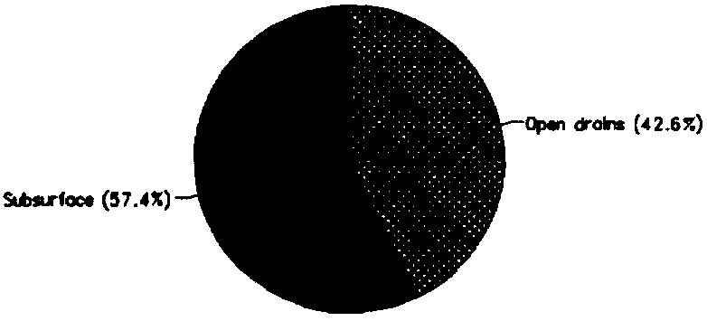
An extensive National Drainage Programme has been carried out over the last 30 years to control waterlogging and salinity. The drainage system consists of open drains, subsurface drains and pumping stations. Of the total irrigated area, 2 931 000 ha are drained, of which 1 681000 ha with subsurface drainage (Figure 4). The subsurface drained area represents nearly 52% of the total cultivated area and more than 74 % of the cultivated land in the valley and Delta. There are 99 pump stations devoted to pumping of drainage effluent. The power drained area was estimated at 1 100 000 ha in 1988. Drainage water from agricultural areas on both sides of the Nile Valley is returned to the Nile River, in Upper Egypt and in the Southern Delta.
Drainage water in the delta is either pumped back into irrigation canals for re-use or pumped into northern lakes or the Mediterranean. In Fayoum province, irrigation is practiced by gravity with no water lifting system. Drainage water is there pumped away into Wadi Rayan and Qaroon lake. Currently, 4.7 km³ of drainage water is being re-used yearly.
Saline areas in the Nile valley and delta were estimated at 1 210 000 ha in 1972, due to seawater intrusion and high water table. Soil salinity in Upper Egypt developed mainly after the construction of the Aswan High Dam and the conversion of flood irrigation into perennial irrigation. Most of the salt-affected agricultural land in the country has now been provided with drainage systems for leaching the excess salts.
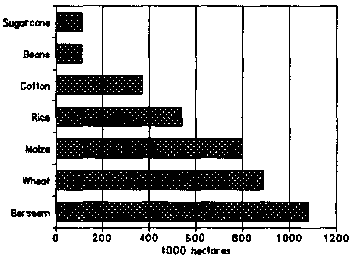
The cropped area is nearly double the cultivated area (Figure 5). There are three cropping seasons in Egypt: Winter (November to May), Summer (April/May to October), and Nili (July/August to October). On the old lands, the cropping intensities can be very high (200%), but on the new lands intensities can reach only 150%, mainly because of water shortages and the lack of means of production in those areas. Most crops are grown both in the Delta and Valley, with exception of rice (Delta mainly) and sugar cane (Valley). The main winter crop is berseem (Trifolium alexandrinum), grown either over 3 months with only 2 cuts as a soil improver (short berseem), or over 6-7 months, either with 4-5 cuts as a fodder crop or grazed by tethered cattle (long berseem). Other minor winter crops are barley, sugar beet and pulses. The main summer crops are maize, rice and cotton, which is the most important Egyptian export crop. Yields have continually increased during the past decades, particularly on the old lands. In 1993, yields were 5.4 t/ha for wheat, 7.0 t/ha for maize, 7.7 t/ha for rice, and 1.2 t/ha for cotton.
FIGURE 3: Irrigation techniques (1990)
FIGURE 4: Types of drainage method. (1993)
FIGURE 5: Irrigated crops (1993)
The average cost for irrigation development is about $US 1 600/ha for drip irrigation, $US 1 300/ha for mobile sprinkler irrigation, and $US 3 200/ha for stationery sprinkler irrigation. Farmers are not charged for irrigation water but pay a tax which is based on the size of their irrigated land.
INSTITUTIONAL ENVIRONMENT
The Ministry of Public Works and Water Resources (MPWWR) is in charge of water resources research, development and distribution, and undertakes the construction, operation and maintenance of the irrigation and drainage networks. At central level, the Planning Sector is responsible for data collection, retrieval and analysis for planning and monitoring investment projects. Water resources development works are coordinated by the Sector of Public Works and Water Resources. The Nile Water Sector is in charge of cooperation with Sudan and other Nilotic countries. The Irrigation Department provides technical guidance and monitoring of irrigation development, including dams. The Mechanical and Electrical Department is in charge of construction and maintenance of pumping stations for irrigation and drainage.
Further to these institutions, other public authorities operate in direct relation to the MPWWR. They are the High Aswan Dam and Aswan Authority, responsible for the dam operation; the Drainage Authority, responsible for the construction and maintenance of tile drains; and the Water Research Centre. The Water Research Centre comprises 11 institutes and is the scientific body of MPWWR for all aspects related to water resources management.
The Ministry of Agriculture and Land Reclamation (MALR) is in charge of agricultural research and extension, land reclamation and agricultural development.
TRENDS IN WATER RESOURCES MANAGEMENT
One important characteristic of Egyptian agriculture is the distribution of land. More than 95% of the landowners hold less than 5 feddans (2.08 ha) each. Only 3% own 50 feddans (20.8 ha) or more.
It is planned to develop an additional 1 189 000 ha for agriculture by the year 2000. This will be achieved through developing the country's surface water and groundwater resources, improving the efficiency of irrigation and increasing drainage water re-use to 7.7 km³ annually. Al Salam canal, now under construction, is planned for re-use of drainage water from two main drains in the Eastern Delta Province (Lower Serw and Bahr Hadous). This water, added to water extracted from the Damietta branch of the Nile, will be used for the irrigation of a new area of 252 000 ha in the Eastern Delta and North Sinai.
MAIN SOURCES OF INFORMATION
ACSAD [Arab Centre for the Study of Arid Zones and Dry Lands]. 1988. Water Resources Assessment in the Arab Region. Damascus.
Attia, F.A.R. 1993. Environmentally sound management of Egyptian groundwater resources. In: [Proceedings of the] Seminar on Techniques of Groundwater Management in the Arab Region. 20-23 December 1993.
CAPMAS [Central Agency for Public Mobilisation and Statistics]. 1993. Crop Acreage and cultivated areas in the Arab Republic of Egypt.
CAPMAS. 1994. Statistical yearbook, Arab Republic of Egypt.
Drainage Research Institute. 1989. Land Drainage in Egypt. Amer & de Ridder Editions.
Drainage Research Institute. 1989. Drainage water in the Nile Delta: Re-use monitoring programme. Report No. 32.
Othman, Y. 1994. Experiences in integrated land and water management. In: Proceedings of the ISAWIP Final Seminar. Port-Said, Egypt, 18-21 April 1994.
Public Authority for Drainage Projects, Ministry of Public Works and Water Resources. 1994. Nile Delta Drainage 'V' Project. Project completion report.
Rofail, N., & Zahran, M.S. 1994. Available water resources in the Arab world and expected future demand. Paper prepared for the ACSAD preparatory expert meeting for the Arab Ministerial Conference on Sustainable Agriculture and Rural Development, Arab League Centre, Cairo, 25-29 September 1994.
Sarris, A.H. 1991. Structural adjustment and agricultural development in Egypt: Policies, prospectives and options.