GEOGRAPHY, POPULATION AND WATER RESOURCES
Equatorial Guinea has a total area of 28 050 km², in three main parts:
Total cultivated area is estimated to be about 230 000 ha, which is 8% of the total area.
The population is about 389 000 (1994), of which 71% is rural. The annual population growth rate is estimated to be 2.3%. Average population density is 14/km², but varies from 4 on Rio Muni, to 35 on Bioko island, and is 120/km² on Annobon island.
The agricultural sector contributes 55% of the GDP.
Climate and water resources
The climate is equatorial, with frequent and abundant rainfall throughout the year, but the major part of the rainfall occurs between April and November. Average annual precipitation is estimated to be 2 077 mm, but is a little higher on Bioko island. The territories have contrasting relief: Pic de Santa Isabel on the mainland rises to 2 853 m, and Pic Basile on Bioko island rises to 3 011 m. Temperatures and rainfall vary mainly with altitude.
Average rainfall is more than 3 000 mm/year above 1 500 m altitude, and only 1 200 mm/year below 600 m altitude.
TABLE 1
Basic statistics and population
| Area of the country | 1994 | 2 805 000 ha |
| Cultivable land | - ha | |
| Cultivated land | 1994 | 230 000 ha |
| Total population | 1994 | 389 000 inhab. |
| Population density | 1994 | 14 inhab./km² |
| Rural population | 1990 | 71 % |
| Water supply coverage | ||
| Urban population | 1990 | 65 % |
| Rural population | 1990 | 18 % |
TABLE 2
Water balance
| Water resources: | |||
| Average precipitation | 2 077 | mm/yr | |
| 58.3 | km³/yr | ||
| Internal renewable water resources - total | 30.0 | km³/yr | |
| Internal renewable water resources - per caput | 1994 | 77 121 | m³/yr |
| Global renewable water resources | 30.0 | km³/yr | |
| Dependency ratio | 0 | % | |
| Total dam capacity | - | km³ | |
| De-salinated water | - | 10 6 m³/yr | |
| Water withdrawal: | |||
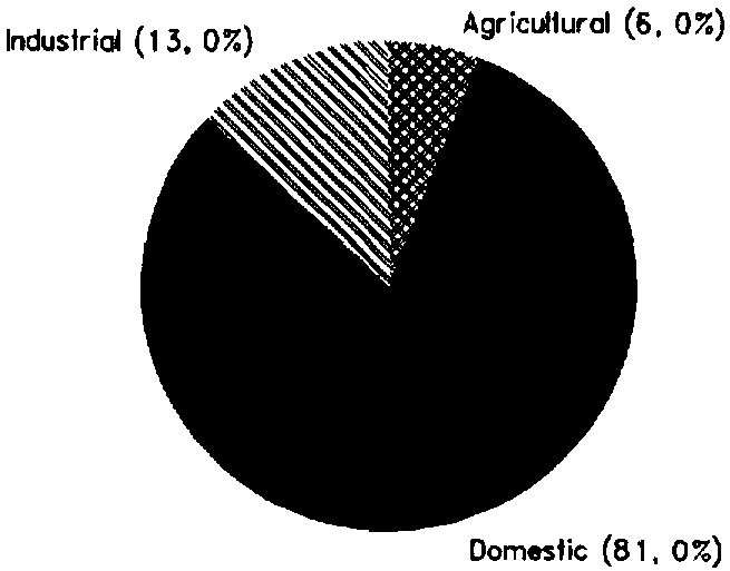
| - Agricultural | 1987 | 0.6 | 10 6 m³/yr |
| - Domestic | 1987 | 8.1 | 10 6 m³/yr |
| - Industrial | 1987 | 1.3 | 10 6 m³/yr |
| Total | 10.0 | 10 6 m³/yr | |
| per caput | 1987 | 31 | m³/yr |
| as a % of internal renewable water resources | 0.03 | % | |
| Other withdrawal | - | 10 6 m³/yr | |
| Wastewater: | |||
| Produced | - | 10 6 m³/yr | |
| Treated | - | 10 6 m³/yr | |
| Re-used treated wastewater | - | 10 6 m³/yr |
TABLE 3
Irrigation and drainage
| Irrigation potential | - | ha | |
| Irrigation: | |||
| 1. Full or partial control Irrigation: equipped area | - | ha | |
| - surface irrigation | - | ha | |
| - sprinkler irrigation | - | ha | |
| - micro-irrigation | - | ha | |
| % of area irrigated from groundwater | - | % | |
| % of area irrigated from surface water | - | % | |
| % of equipped area actually irrigated | - | % | |
| 2. Spate irrigation area | - | ha | |
| 3. Equipped wetland and inland valley bottoms | - | ha | |
| 4. Other cultivated wetland and inland valley bottoms | - | ha | |
| 5. Flood recession cropping area | - | ha | |
| Total water managed area (1 +2+3+4+5) | - | ha | |
| - as % of cultivated area | - | % | |
| - increase over last 10 years | - | % | |
| - power irrigated area as % of water managed area | - | % | |
| Full or partial control schemes: | Criteria | ||
| Large schemes | > - ha | - | ha |
| Medium schemes | - | ha | |
| Small schemes | < - ha | - | ha |
| Total number of households in irrigation | |||
| Irrigated crops: | |||
| Total irrigated grain production | - | t | |
| as % of total grain production | - | % | |
| Harvested crops under irrigation | - | ha | |
| - | - | ha | |
| ha | |||
| Drainage - Environment: | |||
| Drained area | - | ha | |
| as % of cultivated area | - | % | |
| Flood-protected area | - | ha | |
| Area salinized by irrigation | - | ha |
The mainland part is crossed by big watercourses, such as the Rio Campo, the Rio Benito and the Rio Mitemele, which converge in the vast estuary of the Muni, in the south of the country. Renewable water resources are estimated at 30 km³ per year. Total water withdrawal was estimated at 10 million m³ in 1987 (Figure 1).
IRRIGATION DEVELOPMENT
The main agricultural products in Equatorial Guinea are timber, cocoa, coffee, palm oil and bananas. Annual crops are dominated by cassava. With the high level of rainfall, its good distribution throughout the year, and the high level of natural resources such as land and forest, there is no real need for irrigation, and no irrigated areas have yet been developed.
INSTITUTIONAL ENVIRONMENT
Two Ministries are in charge of Agriculture and Natural Resources:
TRENDS IN WATER RESOURCES MANAGEMENT
As noted above, irrigation is not a priority in Equatorial Guinea. The main 'water' problem is drinking water supply. Only 18% of the rural population has access to safe drinking water, and in urban areas the water supply systems are not efficient: less than 30% for Malabo's system. Moreover, since there is no management of wastewater, which goes directly to the sea, the problem of contamination of drinking water by pollutants should be closely monitored in the near future.
FIGURE 1: Water withdrawal (total: 0.01 km³ in 1987)
MAIN SOURCES OF INFORMATION
FAO. 1988. Equatorial Guinea: Agricultural sector review working papers. FAO Investment Centre/World Bank Cooperative Programme report 33/88 CP-EQG 7 WPs. Rome.
FAO. 1992. Estudios de apoyo a la preparacion del proyecto manejo y conservacion de los recursos naturales. Plan director de uso de la tierra para la isla de Bioko. Report prepared by C. van Hoof for project UTF/EQG/002/EQG. Rome.
FAO. 1994. Equatorial Guinea: Natural resources management and conservation project. Preparation report. FAO/DDC report 12/94 CP-EQG 11 (E). Rome.