GEOGRAPHY, POPULATION AND WATER RESOURCES
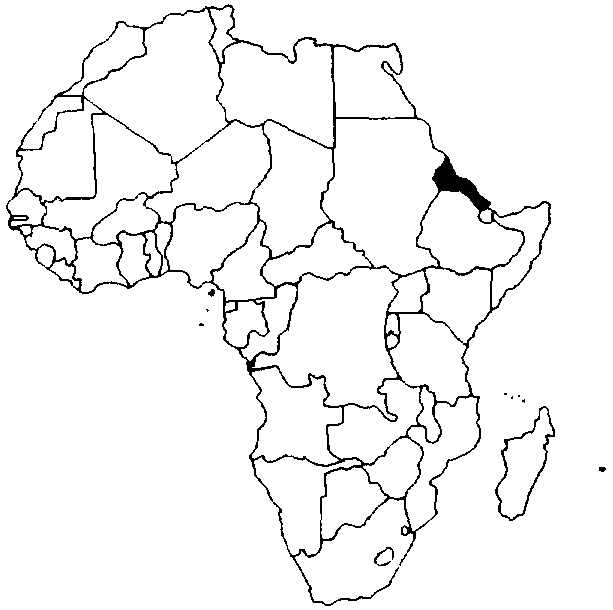
Eritrea, situated in northeastern Africa, along the Red Sea, has a total area of about 122 000 km² The cultivable land is about 1.6 million ha, which is 13% of the total area. Cultivated land is 439 000 ha, i.e., 26% of the cultivable area and 4% of the total area.
The total population was estimated at about 3.4 million inhabitants in 1994, with a growth rate higher than 3% annually. The density is 28/km², but 65% of the population live in the four highland provinces, although they account for only 16% of the total land area (Asmara, Hamasien, Akele Gusai, and Seraye).
TABLE 1
Basic statistics and population
| Area of the country | 1994 | 12 189 000 ha |
| Cultivable land | 1993 | 1 650 000 ha |
| Cultivated land | 1993 | 439 000 ha |
| Total population | 1994 | 3 437 000 inhab. |
| Population density | 1994 | 28 inhab./km² |
| Rural population | - % | |
| Water supply coverage | ||
| Urban population | - % | |
| Rural population | - % |
Agriculture represents 26% of the GDP, which is about $US 350 million.
Climate and water resources
The climate ranges from hot arid, adjacent to the Red Sea, to temperate sub-humid in isolated micro-catchments within the eastern escarpment of the highlands. Some areas of the country are more than 3 000 m in elevation, and the average annual temperature ranges from 21°C in the highlands to 25°C in the lowlands. Total annual rainfall increases from less than 200 mm at the northern border with Sudan to more than 700 mm in a restricted area on the southern border with Ethiopia. A small area on the eastern escarpment, known as the green belt, receives over 900 mm/year on average.
Eritrea has three main drainage systems:
TABLE 2
Water balance
| Water resources: | |||
| Average precipitation | 329 mm/yr | ||
| 40.1km³/yr | |||
| Internal renewable water resources - total | 2.8 km³/yr | ||
| Internal renewable water resources - per caput | 1994 | 815 | m³/yr |
| Global renewable water resources | 8.8 km³/yr | ||
| Dependency ratio | 68.2 | % | |
| Total dam capacity | 1993 | 0.03 | km³ |
| De-salinated water | - | 10 6 m³/yr | |
| Water withdrawal: | |||
| - Agricultural | - | 10 6 m³/yr | |
| - Domestic | - | 10 6 m³/yr | |
| - Industrial | - | 10 6 m³/yr | |
| Total | - | 10 6 m³/yr | |
| per caput | - | m³/yr | |
| as % of internal renewable water resources | - | % | |
| Other withdrawal | - | 10 6 m³/yr | |
| Waste water: | |||
| Produced | - | 10 6 m³/yr | |
| Treated | - | 10 6 m³/yr | |
| Re-used treated wastewater | - | 10 6 m³/yr |
TABLE 3
Irrigation and drainage
| Irrigation potential | - | ha | |
| Irrigation: | |||
| 1. Full or partial control Irrigation: equipped area | 1993 | 12 494 | ha |
| - surface irrigation | - | ha | |
| - sprinkler irrigation | - | ha | |
| - micro-irrigation | - | ha | |
| % of area irrigated from groundwater | - | % | |
| % of area irrigated from surface water | - | % | |
| % of equipped area actually irrigated | 1993 | 48 | % |
| 2. Spate irrigation area | 1993 | 15 630 | ha |
| 3. Equipped wetland and inland valley bottoms | - | ha | |
| 4. Other cultivated wetland and inland valley bottoms | - | ha | |
| 5. Flood recession cropping area | - | ha | |
| Total water managed area (1 + 2 + 3 + 4 + 5) | 1993 | 28 124 | ha |
| - as % of cultivated area | 1993 | 6.4 | % |
| - increase over last 10 years | - | % | |
| - power irrigated area as % of water managed area | - | % | |
| Full or partial control schemes: | Criteria | ||
| Large schemes | > - ha | - | ha |
| Medium schemes | - | ha | |
| Small schemes | < - ha | - | ha |
| Total number of households in irrigation | |||
| Irrigated crops: | |||
| Total irrigated grain production | - | t | |
| as % of total grain production | - | % | |
| Harvested crops under irrigation (full or partial control! | - | ha | |
| - fruits + vegetables | 1993 | 4 109 | ha |
| - cotton | 1993 | 1 860 | ha |
| - | - | ha | |
| Drainage - Environment: | |||
| Drained area | - | ha | |
| as % of cultivated area | - | % | |
| Flood-protected area | - | ha | |
| Area salinized by irrigation | - | ha |
Although no measurement of runoff is available, a rough estimate would put internally produced water resources at around 2.8 km³/year, most of which would be located in the western part of the country. The most important river course is the Tekeze-Setit, at the border with Ethiopia, with more than 90% of its catchment situated inside Ethiopia. Estimates of mean annual flow of the Setit at the border with Sudan vary between 6 and 8 km³/year.
In 1993, 109 small dams, built mainly for irrigation in the recent past, had a total storage capacity of 24 million m³ A storage reservoir of 8 million m³ was built in the 1960s on the Gash river to irrigate the Alighider Estate, but needs regular de-silting. Several major dams, built longer ago, are completely silted, such as the Foro dam, which had a storage capacity of 4 million m³ just after its construction in the 1920s. In the 1960s, a new dam was built at Foro on the River Haddas, with a capacity of 23 million m³ but by 1988 this reservoir was also completely silted up,
The main sources of domestic water in rural areas are tubewells and shallow wells.
The present status of rural water supply is unknown, and the Water Resources Department is undertaking a national inventory of all water points.
IRRIGATION DEVELOPMENT
Several estimates of the irrigation potential have been made. The largest one, 567 000 ha, does not take into account water availability. Others estimations (107 000 ha or 270 960 ha, according to two different studies) are based on unproven groundwater resources. They do not cover the eastern lowlands, nor small-scale irrigation potential in the uplands.
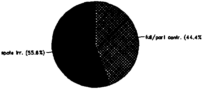
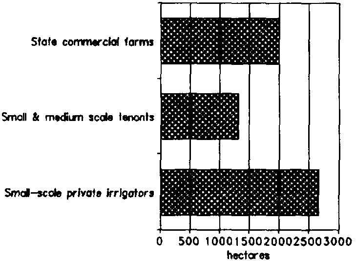
Of a Total water managed area of 28 124 ha in 1993, 12 494 ha were equipped for irrigation with full or partial control and 15 630 ha were under spate irrigation (Figure 1). The area under spate irrigation seems to be an overestimate, since much of the spate irrigation area in the eastern lowlands, an area severely affected by the war, is out of production at present. Of the area equipped for irrigation with full or partial control, only 5 969 ha, or 48%, were actually irrigated with different types of management (Figure 2).
FIGURE 1: Distribution of the water managed areas (1993)
FIGURE 2: Irrigation management (1994)
- the Alighider Estate, located on the lower Gash river near Tennessey, with 8 000 ha equipped, but only irrigated on 1 860 ha of cotton in 1993; and
- the Elaberet Estate, an agro-industrial complex of 1 200 ha located 450 km northeast of Asmara, with 520 ha equipped, but only irrigated on 135 ha in 1993.
These two systems are irrigated by river diversion and storage reservoirs, supplemented by wells in case of drought.
Several estimations of irrigation development costs are given by the FAO identification project:
INSTITUTIONAL ENVIRONMENT
The different institutions involved in water resources and irrigation are:
Water legislation was under preparation in 1994.
TRENDS IN WATER RESOURCES MANAGEMENT
Since independence, a rapid development of concessions for modern, mostly irrigated, agriculture in the southwestern lowlands has been observed. The rehabilitation of spate irrigation systems should be seen in the next few years.
Sedimentation is a very important problem, that should be taken into account in the operation and maintenance costs, as reservoirs are quickly silted up, canals filled with sediment and the lifetime of pumps reduced.
The new strategy in the irrigation subsector suggested by FAO to the Government in its Agricultural Sector Review of 1994 is:
MAIN SOURCES OF INFORMATION
FAO. 1994. Eritrea - Agricultural sector review and project identification. 3 volumes. Report prepared by FAO/IC under Technical Cooperation Programme project TCP/ERI/2353. Rome.