GEOGRAPHY, POPULATION AND WATER RESOURCES
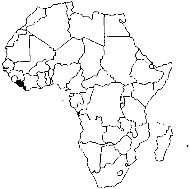
Liberia, located in the southwestern part of West Africa, covers an area of 97 750 km². The country can be divided according to elevation over sea level into four main physical regions parallel to the coast: coastal plains up to 100 m, hills from 100 to 300 m, plateaus from 300 to 600 m, and mountainous areas above 600 m. The cultivated area was estimated at 538 000 ha in 1986, which is 5.5% of the total area.
Total population is about 2.9 million (1994), of which 55% is rural. Average population density is 30 inhabitants/km². Population growth rate was estimated to be 3.3% at the end of the 1980s
TABLE 1
Basic statistics and population
| Area of the country | 1994 | 9 775 000 ha |
| Cultivable land | - ha | |
| Cultivated land | 1986 | 538 000 ha |
| Total population | 1994 | 2 941 000 inhab. |
| Population density | 1994 | 30 inhab./km² |
| Rural population | 1990 | 55 % |
| Water supply coverage | ||
| Urban population | 1991 | 35 % |
| Rural population | 1991 | 35 % |
The agricultural sector represented about 35% of GDP before the conflict, and employed 60% of the labour force.
Climate and water resources
The climate is of the tropical type, with heavy rainfall that ranges from 2 000 to 3 000 mm/year. Average annual rainfall is estimated at 2 372 mm. The rainy season lasts from April to November.
Liberia can be divided into two kinds of river systems:
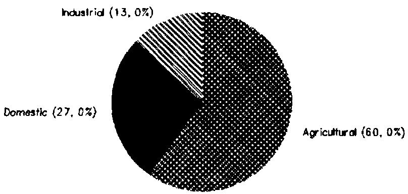
The internally produced renewable water resources are estimated at 200 km³/year, while an additional 32 km³/year comes from Guinea and Côte d'Ivoire. Liberia is thus one of the African countries with the highest amount of renewable water resources per inhabitant: more than 68 000 m³/year. Total water withdrawal was estimated at 0.13 km³ in 1987 (Figure 1).
TABLE 2
Water balance
| Water resources: | |||
| Average precipitation | 2 372 | mm/yr | |
| 231.9 | km³/yr | ||
| Internal renewable water resources - total | 200 | km³/yr | |
| Internal renewable water resources - per caput | 1994 | 68 004 | m³/yr |
| Global renewable water resources | 232 | km³/yr | |
| Dependency ratio | 13.8 | % | |
| Total dam capacity | - | km³ | |
| De-salinated water | - | 10 6 m³/yr | |
| Water withdrawal: | |||
| - Agricultural | 1987 | 78.0 | 10 6 m³/yr |
| - Domestic | 1987 | 35.1 | 10 6 m³/yr |
| - Industrial | 1987 | 16.9 | 10 6 m³/yr |
| Total | 130.0 | 10 6 m³/yr | |
| per caput | 1987 | 55.3 | m³/yr |
| as a % of internal renewable water resources | 0.06 | % | |
| Other withdrawal | - | 10 6 m³/yr | |
| Wastewater: | |||
| Produced | - | 10 6 m³/yr | |
| Treated | - | 10 6 m³/yr | |
| Re-used treated wastewater | - | 10 6 m³/yr |
TABLE 3
Irrigation and drainage
| Irrigation potential | 1986 | 600 000 | ha |
| Irrigation: | |||
| 1. Full or partial control Irrigation: equipped area | 1987 | 100 | ha |
| - surface irrigation | - | ha | |
| - sprinkler irrigation | - | ha | |
| - micro-irrigation | - | ha | |
| % of area irrigated from groundwater | % | ||
| % of area irrigated from surface water | - | % | |
| % of equipped area actually irrigated | - | % | |
| 2. Spate irrigation area | - | ha | |
| 3. Equipped wetland and inland valley bottoms | 1987 | 2 000 | ha |
| 4. Other cultivated wetland and inland valley bottoms | 1986 | 18 000 | ha |
| 5. Flood recession cropping area | - | ha | |
| Total water managed area (1 + 2 + 3 + 4 + 5) | 1987 | 20 100 | ha |
| - as a % of cultivated area | 1986 | 4.1 | % |
| - increase over last 10 years | - | % | |
| - power irrigated area as % of water managed area | - | % | |
| Full or partial control schemes: | Criteria | ||
| Large schemes | > - ha | - | ha |
| Medium schemes | - | ha | |
| Small schemes | < - ha | - | ha |
| Total number of households in irrigation | |||
| Irrigated crops: | |||
| Total irrigated grain production | - | t | |
| as a % of total grain production | - | % | |
| Harvested crops under irrigation | - | ha | |
| - rice | - | ha | |
| ha | |||
| Drainage - Environment: | |||
| Drained area | - | ha | |
| as a % of cultivated area | - | % | |
| Flood-protected area | - | ha | |
| Area salinized by irrigation | - | ha |
IRRIGATION DEVELOPMENT
The irrigation potential in Liberia is estimated at 600 000 ha, consisting mainly of freshwater swamps.
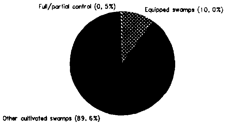
The Total water managed area was about 20 100 ha in 1987 (Figure 2).
The area equipped for full or partial control irrigation was about 100 ha, consisting mainly of small development projects supported through international or bilateral cooperation.
The equipped wetland and inland valley bottoms covered 2 000 ha in 1987, mainly cropped with rice.
The other cultivated wetlands and swamps cover an area of 18 000 ha. Rice is grown in these swamps, in addition to the upland rice. Shifting cultivation on the uplands is still the main technique: the secondary forest is cleared and burned, and upland rice is cropped during one or two years with different food crops (cassava, common groundnuts or vegetables). Afterwards, the area returns to bush fallow for eight to ten years. In 1986, about 235 000 ha of rainfed rice were cultivated in the uplands. This system is the preferred mode of farming in Liberia and has the advantage of maintaining the ecological system in equilibrium. However, this system cannot be applied in areas where a higher population density prevents the restoration of soil fertility due to too short a period of fallow. In those areas, swamp rice is cultivated in addition to upland crops. The estimated yield of upland rice is 1.3 t/ha, while swamp rice gives yields of 1.6 t/ha, reaching more than 2 t/ha in equipped wetland and swamps.
INSTITUTIONAL ENVIRONMENT
The National Water Resources and Sanitation Board was created in 1981 in order to coordinate the activities of the different Institutions or Corporations involved in the management of water resources.
FIGURE 1: Water withdrawal (total: 0.13 km³ in 1987)
FIGURE 2: Distribution of the water managed areas (1987)
Before the conflict, the main institutions involved were:
TRENDS IN WATER RESOURCES MANAGEMENT
The development of swamp rice cultivation seems to be the next step in irrigation development in Liberia. This development will become necessary with increasing population density in the rural areas. It has been estimated that with an intensification of swamp rice cultivation, it could be possible for Liberia to become self-sufficient in rice, which is the staple food crop. The urban demand for rice is rapidly expanding, since the urban population growth rate was estimated at 6.5% in the 1980s.
However, the rate of swamp development in the last years before the conflict were below expectations. When peace returns, successful swamp rice production development will require:
MAIN SOURCES OF INFORMATION
FAO. 1986. Liberia, report of an agricultural sector review mission. Report 85/86 CP-LIR.8