GEOGRAPHY, POPULATION AND WATER RESOURCES
The Libyan Arab Jamahiriya, situated on the northwest Mediterranean coast of Africa, has a total area of about 1.76 million km². The cultivable area is estimated at 2 170 000 ha, which is 1.2% of the total area.
TABLE 1
Basic statistics and population
| Area of the country | 1993 | 175 954 000 ha |
| Cultivable land | 1992 | 2 170 000 ha |
| Cultivated land | 1987 | 1 933 648 ha |
| Total population | 1994 | 5 225 000 inhab. |
| Population density | 1994 | 3 inhab./km² |
| Rural population | 1990 | 18 % |
| Water supply coverage | ||
| Urban population | 1990 | 100 % |
| Rural population | 1990 | 80 % |
The total population is about 5.2 million inhabitants (1994). The population density is 3 inhabitants/km² and the rural population was estimated to be only 18% in 1990. Agriculture contributes less than 5 % to GDP, although it provides employment for approximately 13 % of the active population.
Climate and water resources
The average annual rainfall is 26 mm. It is more than 100 mm/year over only 7% of the land surface. The highest rainfall occurs in the northern Tripoli region (Jabal Nafusah and Jifarah Plain) and in the northern Binghazi region (Jabal al Akhdar): these two areas being the only ones where the average yearly rainfall exceeds the minimum value (250-300 mm) which is considered necessary to sustain rainfed agriculture. Rainfall occurs during the winter months and shows an extreme variability from year to year and from place to place.
The total mean annual runoff water calculated or measured at the entrance of the wadis in the plains is estimated at 200 million m³/year, but part of it either evaporates or contributes to recharge of aquifers. Therefore the surface water resources are roughly estimated at 100 million m³/year. Sixteen dams, with a total storage capacity of 387 million m³ and with an expected average annual volume of water controlled in the order of 60 million m³ had been constructed by 1991. Additional dams are planned, to achieve a total storage capacity of 686 million m³ This disproportion between the average annual runoff and the storage capacity of the dams is made with the purpose of storing the runoff water of exceptionally wet years.
TABLE 2
Water balance
| Water resources: | |||
| Average precipitation | 26 | mm/yr | |
| 46.1 | km³/yr | ||
| Internal renewable water resources - total | 0.6 | km³/yr | |
| Internal renewable water resources - per caput | 1994 | 115 | m³/yr |
| Global renewable water resources | 0.6 | km³/y | |
| Dependency ratio | 0 | % | |
| Total dam capacity | 1992 | 0.4 | km³ |
| De-salinated water | 1988 | 70 | 10 6 m³/yr |
| Water withdrawal: | |||
| - Agricultural | 1994 | 4 000 | 10 6 m³/yr |
| - Domestic | 1994 | 500 | 10 6 m³/yr |
| - Industrial | 1994 | 100 | 10 6 m³/yr |
| Total | 4 600 | 10 6 m³/yr | |
| per caput | 1994 | 880 | m³/yr |
| as % of internal renewable water resources | 767 | % | |
| Other withdrawal | - | 10 6 m³/yr | |
| Wastewater: | |||
| Produced | - | 10 6 m³/yr | |
| Treated | 1990 | 100 | 10 6 m³/yr |
| Re-used treated wastewater | 1990 | 100 | 10 6 m³/yr |
TABLE 3
Irrigation and drainage
| Irrigation potential | 1992 | 750 000 | ha |
| Irrigation: | |||
| 1. Full or partial control Irrigation: equipped area | 1990 | 470 000 | ha |
| - surface irrigation | - | ha | |
| - sprinkler irrigation | 1990 | 470 000 | ha |
| - micro-irrigation | - | ha | |
| % of area irrigated from groundwater | - | % | |
| % of area irrigated from surface water | - | % | |
| part of the equipped area actually irrigated | 1990 | 51 | % |
| 2. Spate irrigation area | - | ha | |
| 3. Equipped wetland and inland valley bottoms | - | ha | |
| 4. Other cultivated wetland and inland valley bottoms | - | ha | |
| 5. Flood recession cropping area | - | ha | |
| Total water managed area (1 + 2 + 3 + 4 + 5) | 1990 | 470 000 | ha |
| as % of cultivated area | - | % | |
| increase over last 10 years | - | % | |
| power irrigated area as % of water managed area | - | % | |
| Full or partial control schemes: | Criteria | ||
| Large schemes | > - ha | - | ha |
| Medium schemes | - | ha | |
| Small schemes | < - ha | - | ha |
| Total number of households in irrigation | |||
| Irrigated crops: | |||
| Total irrigated grain production | - | t | |
| as % of total grain production | - | % | |
| Harvested crops under irrigation | - | ha | |
| - | - | ha | |
| Drainage - Environment: | |||
| Drained area | - | ha | |
| as % of cultivated area | - | % | |
| Flood-protected area | - | ha | |
| Area salinized by irrigation | - | ha |
Currently, recharge of aquifers occurs only in the northern regions, namely in the northwestern zone, Jabal Nafusah and Jifarah Plain, and in the northeastern zone, Jabal al Akhdar. Renewable groundwater resources are estimated at 0.8 to 1 km³/year, but part of it (perhaps 50%) now flows out either to the sea or to evaporative areas (sabkhas) and could not be abstracted without affecting the environment, because of the deterioration of water quality by saline water encroachment. South of the 29th parallel, an important development of Palaeozoic and Mesozoic continental sandstones enabled water to be stored safely during the long period of the late Quaternary, when the climate turned extremely arid. The major part of water used in Libya will be coming from these huge fossil reserves.
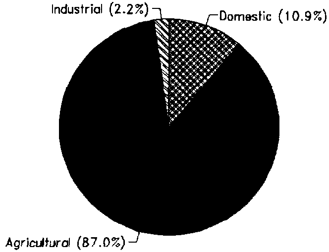
Total water withdrawal for agricultural, domestic and industrial purposes was estimated at 4.6 km³ in 1994 (Figure 1).
A number of de-salination plants of different sizes have been built near large municipal centres and industrial complexes.
The total capacity of installed plants is approximately 140 million m³/year, but parts of them are either not in use or only partly operational. It is estimated that only 70 million m³/year is annually de-salinated.
A number of sewage treatment plants are already in operation or planned for the near future. When all the plants become operational, their total output will average 285 000 m³/day or about 100 million m³/year. All treated water is currently used for irrigation.
IRRIGATION DEVELOPMENT
The Total water managed area is approximately 470 000 ha, most of it for sprinkler irrigation because of the sandy soils prevailing in most areas of Libya. Of these 470 000 ha equipped for full or partial control irrigation, according to figures from several years ago, only 240 000 ha was actually irrigated, distributed as listed in Table 4.
TABLE 4
Regional distribution of irrigatio
| Zone Area actually irrigated (ha) | Water use (10 6 m³/yr)* | Year (approx.) | |
| Murzuq Basin | 50 000 | 551 | 1985 |
| Jabal Nafusah; Suf al Jin; Western Sirte; Hammada el Hamra | 25 000 | 241 | 1985 |
| Jifarah Plain | 100 000 | 500 | 1985 |
| Al Jabal al Akhdar | 40 000 | 150 | 1985 |
| Al Kufrah-As Sarir | 25 000 | 423 | 1990 |
| Total | 240 000 | 1 865 |
* Figures probably under-estimated.
FIGURE 1: Water withdrawal (total: 4.6 km³ in 1994)
There are three different categories of farming in the irrigation sub-sector:
At present, no water fees are imposed on water users.
INSTITUTIONAL ENVIRONMENT
Responsibility for all water resources assessment and monitoring rests with the General Water Authority, while the Secretariat of Agriculture and Animal Wealth is responsible for the development of irrigated agriculture and the implementation of major projects. A special Authority -The Great Manmade River Water Utilization Authority - is responsible for the use for agricultural purposes of the water transported from the desert to the coast. The Secretariat of Municipalities takes care of water supply to urban settlements.
TRENDS IN WATER RESOURCES MANAGEMENT
Irrigation development in Libya is linked to the implementation of the water transport project from the desert. The Great Manmade River Project consists of the following five phases:
Part of the water transported will be used for the water supply of the major cities of the coast: Tripoli, Binghazi, Sirt and Misratah.
MAIN SOURCES OF INFORMATION
Pallas, P. 1980. Water resources of the Socialist People's Libyan Arab Jamahiriya. In: The Geology of Libya. Proceedings of the Second Symposium on the Geology of Libya. London: Academic Press.
Salem, O.M. 1992. The Great Manmade River project. Water Resources Development, 8(4).