GEOGRAPHY, POPULATION AND WATER RESOURCES
Sierra Leone, located in the southwestern part of West Africa, covers 72 000 km² 74% of which is suitable for crop cultivation on a sustainable basis. There are four main physical regions: coastal plains (14%), interior plains (43%), plateaux (22%), and hills and mountains (21 %).
Population is about 4.4 million inhabitants (1994). In 1990, 68% of the population was rural. Annual demographic growth rate is estimated to be between 2.3% and 2.8%.
TABLE 1
Basic statistics and population
| Area of the country | 1992 | 7 174 000 ha |
| Cultivable land | 1992 | 5 360 000 ha |
| Cultivated land | 1990 | 600 000 ha |
| Total population | 1994 | 4 402 000 inhab |
| Population density | 1994 | 61 inhab./km² |
| Rural population | 1990 | 68 % |
| Water supply coverage | ||
| Urban population | 1990 | 80 % |
| Rural population | 1990 | 20 % |
Agriculture is a vitally important component of the national economy. It represents 40% of the GDP and employs 65% of the labour force, mostly in small-scale, peasant production. It accounts for about 30 % of exports. Rice is the main staple food and is grown by more than 95 % of rural families. Domestic rice production fell from 670 000 t in 1976 to 465 000 t in 1987/88. Estimates of annual rice production in the years 1990 to 1992 vary between 200 000 and 400 000 t. Low producer prices and an unfavourable market situation have restricted domestic rice production. Imported rice is estimated to represent an average of 20% of total consumption (120 000 t in 1991) and the last year of rice export was 1953.
Climate and water resources
The country is well watered, with a rainfall of 2 690 mm/year, which makes it one of the most humid countries of Africa. It ranges from 1 900 to more than 4 000 mm/year. The country is situated at the northern limit of the equatorial rainforest zone, with a tropical climate showing two distinct seasons. There is a pronounced dry season from December to March, with 6 to 7% of the annual total rainfall and coinciding with solar radiation of between 25.9 and 60.9 kcal/cm² and low humidity. Relative humidity is between 95 and 100% in the rainy season but it can drop down to 20% in the harmattan season. Evaporation is between 1 200 and 1 900 mm/year. The mean daily temperature varies between 25°C and 28°C.
TABLE 2
Water balance
| Water resources: | |||
| Average precipitation | 2 690 | mm/yr | |
| 193.0 | km³/yr | ||
| Internal renewable water resources - total | 160 | km³/yr | |
| Internal renewable water resources - per caput | 1994 | 36 347 | m³/yr |
| Global renewable water resources | 160 | km³/yr | |
| Dependency ratio | 0 | % | |
| Total dam capacity | - | km³ | |
| De-salinated water | - | 10 6 m³/yr | |
| Water withdrawal: | |||
| - Agricultural | 1987 | 329.3 | 10 6 m³/yr |
| - Domestic | 1987 | 25.9 | 10 6 m³/yr |
| - Industrial | 1987 | 14.8 | 10 6 m³/yr |
| Total | 370.0 | 10 6 m³/yr | |
| per caput | 1987 | 96 | m³/yr |
| as a % of internal renewable water resources | 0.2 | % | |
| Other withdrawal | - | 10 6 m³/yr | |
| Wastewater: | |||
| Produced | - | 10 6 m³/yr | |
| Treated | - | 10 6 m³/yr | |
| Re-used treated wastewater | - | 10 6 m³/yr |
TABLE 3
Irrigation and drainage
| Irrigation potential | 1981 | 807 000 | ha |
| Irrigation: | |||
| 1. Full or partial control Irrigation: equipped area | 1992 | 1 000 | ha |
| - surface irrigation | 1992 | 1 000 | ha |
| - sprinkler irrigation | 1992 | 0 | ha |
| - micro-irrigation | 1992 | 0 | ha |
| % of area irrigated from groundwater | - | % | |
| % of area irrigated from surface water | - | % | |
| % of equipped area actually irrigated | - | % | |
| 2. Spate irrigation area | - | ha | |
| 3. Equipped wetland and inland valley bottoms | 1992 | 28 360 | ha |
| 4. Other cultivated wetland and inland valley bottoms | 1992 | 126 000 | ha |
| 5. Flood recession cropping area | - | ha | |
| Total water managed area (1+2+3+4+5) | 1992 | 155 360 | ha |
| - as % of cultivated area | 1992 | 25.9 | % |
| - increase over last 10 years | - | % | |
| - power irrigated area as % of water managed area | - | % | |
| Full or partial control schemes: | Criteria | ||
| Large schemes | > - ha | - | ha |
| Medium schemes | - | ha | |
| Small schemes | < - ha | - | ha |
| Total number of households in irrigation | 1987 | 105 000 | |
| Irrigated crops: | |||
| Total irrigated grain production | 1991 | 230 000 | t |
| as a % of total grain production | 1991 | 38 | % |
| Harvested crops under irrigation | |||
| - rice | 1991 | 155 000 | |
| - cassava | - | ha | |
| - sweet potato | - | ha | |
| - vegetables | - | ha | |
| - groundnut | - | ha | |
| Drainage - Environment: | |||
| Drained area | - | ha | |
| as a % of cultivated area | - | % | |
| Flood-protected area | - | ha | |
| Area salinized by irrigation | - | ha |
There are nine major river systems flowing through the country in a NE to SW direction. Three of them are shared with Guinea and two with Liberia. Internally produced surface runoff is estimated to be about 160 km³/year, although this figure is probably an overestimate. Seasonal variations are important: 11-17% of the annual discharge occurs between December and April, with minimum discharge in April.
The groundwater resources of the country have not been extensively studied and are not used, except for a limited number of rural wells and recent installations for large cities. It corresponds almost totally to the baseflow of the rivers and the permeability of the substratum is high.
There is considerable potential for the development of small-scale hydro-electric schemes that could also be designed to accommodate irrigated agriculture. An inventory has identified 21 sites for hydropower development, with a hydro-electric potential which already exceeds by far the medium-term demand of the country (the total potential is believed to be much higher). At the moment, Sierra Leone has only one major dam, the 68-metre-high Guma dam, supplying water to Freetown.
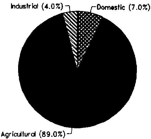
Total water withdrawal was about 0.37 km³ in 1987 (Figure 1). About 80% of the rural population obtains its water from surface sources, including many streams and ponds.
IRRIGATION DEVELOPMENT
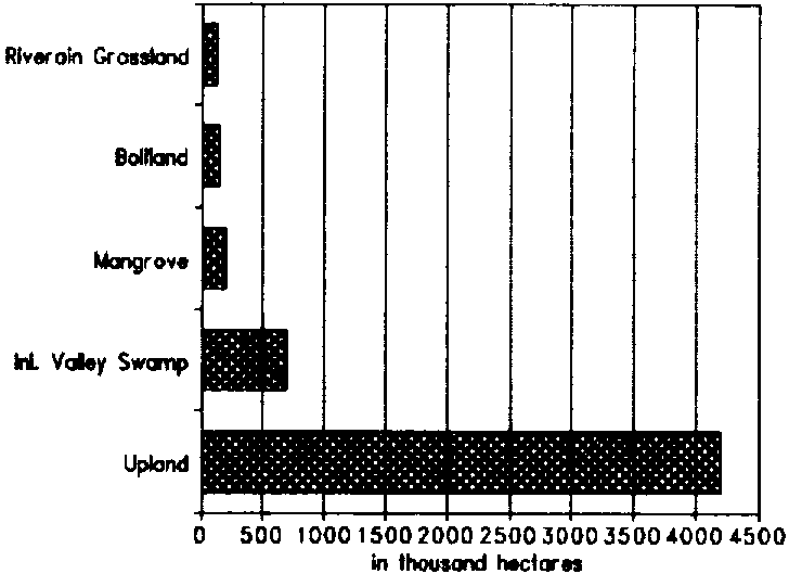
The breakdown of cultivable land into upland and lowland is given in Table 4 and Figure 2. It shows the relative importance of the four classes of lowlands, with a total area of about 1.2 million ha: inland valley swamps (IVS), bolilands which are drainage depressions, mangroves in the coastal tidal zone, and annually flooded riverine grasslands. It should be noted, however, that the 1.2 million ha correspond to the total area of lowlands. Lowland suitable for development is about 807 000 ha, ignoring environmental aspects.
TABLE 4
Breakdown of cultivable and cultivated land
| Ecology | Suitable for cultivation (ha) | Cultivated in 1992 (ha) | Cultivated as % of suitable |
| Upland | 4 200 000 | 500 000 | 11.9 |
| Lowland | 1165 000 | 155 000 | 13.3 |
| - IVS | 690 000 | 100 000 | 14.5 |
| - Boliland | 145 000 | 10 000 | 6.9 |
| - Riverine Grasslands | 130 000 | 20 000 | 15.4 |
| - Mangrove | 200 000 | 25 000 | 12.5 |
| TOTAL | 5 365 000 | 655 000 | 12.2 |
FIGURE 1: Water withdrawal (total: 0.37 km³ in 1987)
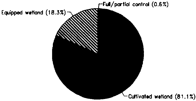
Irrigated agriculture is poorly developed in Sierra Leone. The Total water managed area is estimated at 155 360 ha, but the area with good water control and having the possibility of more than one crop a year is very limited. One thousand hectares are reported to be irrigated for sugar cane production. By 1991, about 28 000 ha of wetland had been equipped for rice cultivation, although most of it is not operational (Figure 3).
The predominant type of farming in Sierra Leone is the bush fallow system, with holdings ranging from 0.5 to 2 ha. Up to 10 different crops are traditionally grown in mixed stands in one season, with rainfed upland rice dominating, being grown by 96% of farmers. Traditionally, farmers use the IVS for rice in the rainy season, followed in the dry season by groundnut, vegetables, potatoes and cassava.
The reduced fallow period induced by increasing population pressure has had adverse impacts on the soil fertility for upland cropping. The IVS have relatively more fertile soils than the upland areas, and can support a higher cropping density. Although the government has attempted to develop double cropping of rice by developing the IVS for irrigation, the high cost of development and weak extension capability has so far made this option not successful.
Yield of rice in traditional wetland is about 1.5 t/ha, while in upland it is around 1 t/ha. In farmer-managed demonstration plots, yields reach an average of 3.2 t/ha. The other two main crops grown in wetland - cassava and sweet potato - have an average yield of 2.2 t/ha and 2.7 t/ha respectively.
INSTITUTIONAL ENVIRONMENT
As water resources have never been a serious constraint to development in Sierra Leone, no base exists for their management, nor does there exist any comprehensive water resources development policy or strategy (except for the water supply and sanitation sector).
Several agencies have been, to a limited extent, involved in the assessment of the potential water resources, such as the Guma Valley Water Company, Department of Energy and Power, Water Supply Division, Geological Survey, and Land and Water Development Division (LWDD) of the Department of Agriculture and Forestry.
FIGURE 2: Land suitable for cultivation
FIGURE 3: Distribution of water managed areas
LWDD is responsible for appraisal of the land and water resources of the country, to help develop sustainable agriculture. It has several technical sections: agronomy, remote sensing, soils, agroclimatology, analytical laboratory, water resources, and cartography.
The Water Resources Section is in charge of investigating the water resources of the country with regard to their utilization for agricultural and rural development. This includes design preparation for swamp development. It liaises with the Water Supply Division of the Ministry of Energy and Power to investigate groundwater resources potential and for the siting and drilling of wells.
TRENDS IN WATER RESOURCES MANAGEMENT
In 1990, the country's target was to reach self-sufficiency in rice production. Swamps are considered as the most promising land for increasing rice production. The development of wetland to allow for double cropping has so far proved to be unadapted and costly. Future efforts will probably concentrate on increasing yields in swamp rice cultivation, by concentrating on the most productive land and intensifying the use of available production technology. The returns from mechanization have proved to be higher in the riverine grasslands than in the other rice cultivation ecologies. Bolis, given their poor soil conditions, are not expected to play a major role in the future in rice production.
However, the future of irrigation and agriculture in general is primarily related to a return to political stability.
MAIN SOURCES OF INFORMATION
Central Statistics Office. 1991. Annual statistics digest 1991.
FAO. 1981. Land resources survey project DP/SIL/73/002: Final Report.
FAO/DDC. 1990. Report on the Moyamba development project. 2 volumes.
Knickel K.W. 1988. Farming system development: Smallholder swamp rice schemes in Sierra Leone.
MAFF/FAO. 1992. Sierra Leone: Agricultural sector review/programming mission. 2 volumes.
World Bank. 1984. Sierra Leone Agricultural sector review.