GEOGRAPHY, POPULATION AND WATER RESOURCES
Somalia, with a total area of 637 660 km² has the longest coastline in Africa: in the north on the Gulf of Aden, and in the east on the Indian Ocean. The cultivable area was estimated at about 8 million ha in 1985, or 13% of the total area, and the cultivated area at about 980 000 ha, or 1.5% of the total area and 12% of the cultivable area.
Population in Somalia is estimated at about 9 million (1994), of which 64% is rural. Average population density is about 14 persons/km². The annual demographic growth rate is al demographic growth rate is approximately 3.1 %. Agronomy is the approximately 3.1 %. Agronomy is the second traditional occupation for most Somalis, after nomadic livestock grazing, and accounted for about 11 % of the country's GDP in the period 1970-1986.
Climate and water resources
The climate of Somalia is of the arid to semi-arid type, with annual rainfall of less than 250 mm in the north, about 400 mm in the south' and 700 mm/Year in the southwest. On average, the country receives about 250 mm/year of rainfall. Rainfall distribution is bimodal. It falls mostly in the gu (mid-April to June) and the der (October to December) seasons. The country is regularly subject to periods of drought.
Water resources in Somalia are dominated by surface water. Along the Gulf of Aden, a mountainous zone with rugged relief is subject to torrential flows, causing considerable erosion. The land slopes down towards the south, and the watercourses which flow southwards peter out in the sands of the desert. The rest of the country consists of a plateau, which is crossed by the two main rivers of Somalia, the Juba and the Shebelle, originating from the Ethiopian plateau and draining in a southeast direction towards the Indian Ocean. Contribution to river flow from inside Somalia is not significant and occurs only during heavy rainfall. Flows in the lower reaches of the two rivers decrease considerably as a result of infiltration, overbank spillage, evaporation and water abstraction. The total internally produced water resources are estimated at 6 km³/year, the incoming surface water resources at 7.5 km³/year.
TABLE 1
Basic statistics and population
| Area of the country | 1992 | 63 766 000 ha |
| Cultivable land | 1985 | 8 150 000 ha |
| Cultivated land | 1984 | 980 000 ha |
| Total population | 1994 | 9 077 000 inhab. |
| Population density | 1994 | 14 inhab./km² |
| Rural population | 1990 | 64 % |
| Water supply coverage | ||
| Urban population | 1990 | 50 % |
| Rural population | 1990 | 29 % |
TABLE 2
Water balance
| Water resources: | |||
| Average precipitation | 253 | mm/yr | |
| 161.3 | km³/yr | ||
| Internal renewable water resources - total | 6.0 | km³/yr | |
| Internal renewable water resources - per caput | 1994 | 661 | m³/yr |
| Global renewable water resources | 13.5 | km³/yr | |
| Dependency ratio | 55.6 | % | |
| Total dam capacity | - | km³ | |
| De-salinated water | 1990 | 0.1 | 10 6 m³/yr |
| Water withdrawal: | |||
| - Agricultural | 1987 | 785.7 | 10 6 m³/yr |
| - Domestic | 1987 | 24.3 | 10 6 m³/yr |
| - Industrial | 1987 | 0 | 10 6 m³/yr |
| Total | 810.0 | 10 6 m³/yr | |
| per caput | 1987 | 99 | m³/yr |
| as a % of internal renewable water resources | 13.5 | % | |
| Other withdrawal | - | 10 6 m³/yr | |
| Wastewater: | |||
| Produced | - | 10 6 m³/yr | |
| Treated | - | 10 6 m³/yr | |
| Re-used treated wastewater | - | 10 6 m³/yr |
TABLE 3
Irrigation and drainage
| Irrigation potential | 1985 | 240 000 | ha |
| Irrigation: | |||
| 1. Full or partial control Irrigation: equipped area | 1984 | 50 000 | ha |
| - surface irrigation | - | ha | |
| - sprinkler irrigation | - | ha | |
| - micro-irrigation | - | ha | |
| % of area irrigated from groundwater | - | % | |
| % of area irrigated from surface water | - | % | |
| % of equipped area actually irrigated | - | % | |
| 2. Spate irrigation area | 1984 | 150 000 | ha |
| 3. Equipped wetland and inland valley bottoms | - | ha | |
| 4. Other cultivated wetland and inland valley bottoms | - | ha | |
| 5. Flood recession cropping area | - | ha | |
| Total water managed area (1 + 2 + 3 + 4 + 5) | 1984 | 200 000 | ha |
| - as a percentage of cultivated area | 1984 | 20.4 | % |
| - increase over last 10 years | - | % | |
| - power irrigated area as % of water managed area | - | % | |
| Full or partial control schemes: Criteria | |||
| Large schemes > - ha | 1984 | 25 000 | ha |
| Medium schemes | 1984 | 0 | ha |
| Small schemes < - ha | 1984 | 25 000 | ha |
| Total number of households in irrigation | 1984 | 33 750 | |
| Irrigated crops: | |||
| Total irrigated grain production | 1984 | 150 000 | t |
| as a % of total grain production | 1984 | 30 | % |
| Harvested crops under irrigation | - | ha | |
| - maize | 1984 | 150 000 | ha |
| - sugar cane | 1984 | 9 800 | ha |
| - bananas | 1984 | 3 000 | ha |
| - rice | 1984 | 1 300 | ha |
| - | - | ha | |
| Drainage - Environment: | |||
| Drained area | - | ha | |
| as a % of cultivated area | - | % | |
| Flood-protected area | - | ha | |
| Area salinized by irrigation | - | ha |
There is no dam on the Shebelle river within Somalia, but off-stream storage exists at Jowhar (200 million m³), upstream from the greater part of the irrigated lands and downstream from the Jowhar Sugar Estate. A second off-stream storage reservoir, which would store 130-200 million m³, is proposed at Duduble, upstream of Jowhar. Another proposed dam is the Baardhere dam on the Juba, primarily for hydropower, but which should also provide maximum water control and storage for the Juba Valley irrigation projects.
The contribution of other drainage basins to surface water is generally insignificant. They normally consist of occasional runoff in seasonal watercourses.
Groundwater potential is limited because of the limited potential for recharge. In the northern region, some subsurface flows in wadis are tapped for small (1-25 ha) irrigated farms. However, studies required for exploration of groundwater are still needed.
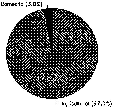
Total water withdrawal was estimated at 0.81 km³ in 1987 (Figure 1). Agricultural water withdrawal, about 0.79 km³ is mainly for the full or partial control irrigation schemes.
IRRIGATION DEVELOPMENT
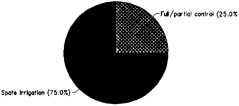
Despite of the importance of irrigation for the main cash crops in Somalia, e.g., bananas and sugar cane, irrigation and drainage systems development is very poor. In the main irrigated area in the Juba and Shebelle Valleys, there is no system of water allocation and management and a salinity problem exists. Irrigation potential is estimated at 240 000 ha. In 1984, the Total water managed area was about 200 000 ha. of which only 50 000 ha had reasonably controlled irrigation, the rest being spate irrigation, entirely for maize production (Figure 2).
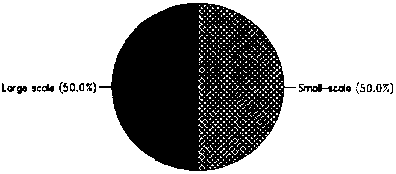
Full or partial control irrigation schemes consist of about half traditional, small-scale schemes and half medium and large private and state schemes (Figure 3), with irrigated farms supporting some 135 000 people. Irrigation is practiced mostly along the Juba and Shebelle Rivers. For irrigation water management and drainage, services are almost non-existent. The lack of an effective water authority or management system is one reason for the low (20-25%) irrigation efficiency and deteriorating performance. Farmers, individually or in groups, abstract water from rivers or canals regardless of crop rotation or crop water needs. Water use is governed by proximity to the distribution outlet and location upstream.
FIGURE 1: Water withdrawal (total: 0.81 km³ in 1987)
FIGURE 2: Distribution of the water managed areas (1984)
FIGURE 3: Typology of full or partial control irrigation schemes
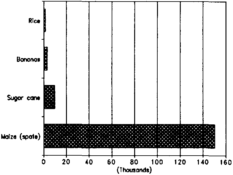
The major irrigated crops (Figure 4) are maize (spate), sugar cane (mainly state farms) and bananas (mainly private farms). Official statistics show that, for the period 1970-1986, a slight decrease in area and a static yield for bananas, while there was an increase in area and considerable drop in yield for sugar cane. This can be attributed mainly to the increasing drainage problems and soil salinity at the Jowhar sugar estate on the Shebelle river. Regarding maize, an important irrigated and rainfed crop, production increased sharply due to the wide expansion of planted area (from 102 000 ha in 1971 to 350 000 ha in 1985), while yields remained low. In irrigated areas, maize yields remained low because of the inefficient irrigation system, limited availability of research, the absence of higher yielding varieties, and shortage of inputs.
INSTITUTIONAL ENVIRONMENT
The main institution in charge of water resources management and development in Somalia is the Ministry of Mineral and Water Resources (MMWR), and its National Water Centre (NWC). The Water Development Agency (WDA) is responsible for operations exploiting groundwater resources for domestic water supply.
TRENDS IN WATER RESOURCES MANAGEMENT
A study carried out by the World Bank in 1987 outlined a proposed strategy to be followed for the development of irrigation, drainage and water management systems. In the short term, the plan included: rehabilitation of the existing systems; completion of the Water Master Plan for the Shebelle and Juba Rivers; registration of all irrigated farms within a cadastral system; allocation of legal water rights, and management of water allocation system; development of an effective system of water charges; gradual transfer of operation and maintenance responsibility to the holders of water rights; and incentives for adaptive research.
In the long term, the construction of the Duduble reservoir for the control of the Shebelle river, and the Baardhere dam on Juba river were projected. However, even with the completion of the Duduble reservoir, the water availability would still be limited in quantity and quality due to the salinity problem. Upstream 'return-to-river' drainage might contribute to higher salinity further downstream unless outfall drains to the ocean are constructed, in which case the maximum area in the Shebelle valley would be about 50 000-60 000 ha, if irrigation efficiency is increased to 50%.
MAIN SOURCES OF INFORMATION
Indian Ocean Newsletters. 1985. Productive Sectors of the Economy.
Kammer D. 1989. A brief description of major drainage basins affecting Somalia. National Water Centre, Mogadishu. Field Document No.14. FAO/SOM/85/008. Rome.
World Bank. 1987. Agricultural Sector Survey: Main report and strategy. Report No. 6131-SO. Washington DC.
FIGURE 4: Areas (ha) of major Irrigated crops (1984)