GEOGRAPHY, POPULATION AND WATER RESOURCES
The Republic of South Africa has a total area of 1.22 million km². Only 15% of the total area - 18 million ha - is considered as cultivable. The cultivated area in 1988 was about 10.8 million ha, excluding the area cultivated in the former homelands.
TABLE 1
Basic statistics and population
| Area of the country | 1994 | 122 104 000 ha |
| Cultivable land | 1994 | 18 320 000 ha |
| Cultivated land | - ha | |
| Total population | 1994 | 40 555 000 inhab. |
| Population density | 1994 | 33 inhab./km² |
| Rural population | 1990 | 51 % |
| Water supply coverage | ||
| Urban population | 1993 | 81 % |
| Rural population | 1993 | 50 % |
The population is estimated at 40.6 million (1994), of which 49% is urban. The average population density is about 33/km², but ranges from more than 100/km² in the rural areas of the former homelands to only 21/km² in the other parts of the country. The annual demographic growth rate is estimated at 2.4%.
The agricultural sector contributes 3.9% to GDP (1991) and employs 9.8% of the economic active population. Nevertheless, agriculture is one of the largest sectors of employment because of the large numbers of peasants in the former homelands, who are not yet included in the statistics.
Climate and water resources
The average annual rainfall is 451 mm, ranging from less than 10 mm in the western deserts to 1 200 mm/year in the eastern part of the country. A vast expanse of the country is considered arid (21% of the area has less than 200 mm/year rainfall) or semi-arid (44% of the area receives between 200 and 500 mm/year). Therefore 65% of the country does not receive enough rainfall for successful dryland farming. The major part of the country has summer rainfall from November to February, while the southwestern corner has hot dry summers and rainy winters.
The drainage network of South Africa comprises two main systems, separated by the high escarpment in the eastern part of the country:
TABLE 2
Water balance
| Water resources: | |||
| Average precipitation | 451 | mm/yr | |
| 550.5 | km³/yr | ||
| Internal renewable water resources - total | 44.8 | m³/yr | |
| Internal renewable water resources - per caput | 1994 | 1 104 | m³/yr |
| Global renewable water resources | 50.0 | m³/yr | |
| Dependency ratio | 10.4 | % | |
| Total dam capacity | 1990 | 26.9 | km³ |
| De-salinated water | 1990 | 17.5 | 10 6 m³/yr |
| Water withdrawal: | |||
| - Agricultural | 1990 | 9 580 | 10 6 m³/yr |
| - Domestic | 1990 | 2 281 | 10 6 m³/yr |
| - Industrial | 1990 | 1 448 | 10 6 m³/yr |
| Total | 13 309 | 10 6 m³/yr | |
| per caput | 1990 | 351 | m³/yr |
| as a % of internal renewable water resources | 29.7 | % | |
| Other withdrawal | 1990 | 5 210 | 10 6 m³/yr |
| Wastewater: | |||
| Produced | 1990 | 1 700 | 10 6 m³/yr |
| Treated | - | 10 6 m³/yr | |
| Re-used treated wastewater | - | 10 6 m³/yr |
TABLE 3
Irrigation and drainage
| Irrigation potential | 1992 | 1 500 000 | ha |
| Irrigation: | |||
| 1. Full or partial control Irrigation: equipped area | 1994 | 1 270 000 | ha |
| - surface irrigation | 1991 | 396 000 | ha |
| - sprinkler irrigation | 1991 | 660 000 | ha |
| - micro-irrigation | 1991 | 144 000 | ha |
| % of area irrigated from groundwater | 1991 | 18 | % |
| % of area irrigated from surface water | 1991 | 82 | % |
| % of equipped area actually irrigated | - | % | |
| 2. Spate irrigation area | - | ha | |
| 3. Equipped wetland and inland valley bottoms | - | ha | |
| 4. Other cultivated wetland and inland valley bottoms | - | ha | |
| 5. Flood recession cropping area | - | ha | |
| Total water managed area (1 + 2 + 3 + 4 + 5) | 1994 | 1 270 000 | ha |
| - as a percentage of cultivated area | - | % | |
| - increase over last 10 years | - | % | |
| - power irrigated area as % of water managed area | - | % | |
| Full or partial control schemes: | Criteria | ||
| Large schemes | > - ha | - | ha |
| Medium schemes | - | ha | |
| Small schemes | < - ha | - | ha |
| Total number of households in irrigation | |||
| Irrigated crops: | |||
| Total irrigated grain production | 1988 | 1 320 000 | t |
| as a % of total grain production | 1988 | 9 | % |
| Harvested crops under irrigation | - | ha | |
| - pasture | 1988 | 202 000 | ha |
| - wheat | 1988 | 170 000 | ha |
| - lucerne | 1988 | 131 000 | ha |
| - maize | 1988 | 106 000 | ha |
| - | ha | ||
| Drainage - Environment: | |||
| Drained area | - | ha | |
| as a % of cultivated area | - | % | |
| Flood-protected area | - | ha | |
| Area salinized by irrigation | - | ha |
The total annual surface runoff is estimated at 45.2 km³ or about 10% of annual rainfall. Of this amount, 40 km³ are generated within the country, while 5.2 km³ come from Lesotho. However, much of this volume is lost through flood spillage and evaporation, so that only about 33 km³/year is economically usable. The total dam capacity is estimated at 26.9 km³ The dams command virtually all the runoff from the plateau, while the untapped resources are concentrated along the coast.
The groundwater resources are estimated at 4.8 km³/year In 1980, about 1.79 km³ were exploited. It is foreseen that groundwater use will increase, especially in the western part of the country, which lacks perennial rivers.
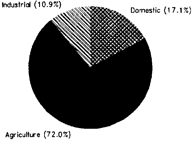
According to a 1986 projection for 1990 by the Department of Water Affairs, total water withdrawal is estimated at 13.3 km³ (1990) (Figure 1), while 5.21 km³ are necessary to maintain the level of lakes and wetlands.
FIGURE 1: Water withdrawal /total: 13.3 km³ in 1990)
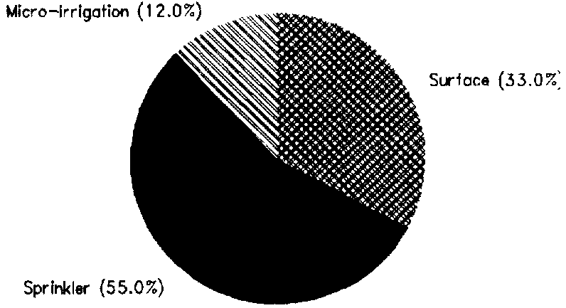
FIGURE 2: Irrigation techniques. full or partial control (1991)
IRRIGATION DEVELOPMENT
The potential for full or partial control irrigation development, based on soil and water availability and suitability, is estimated at 1.5 million ha.
The Total water managed area is estimated at 1.27 million ha, consisting only of full or partial control irrigation. Three irrigation techniques are used (Figure 2).
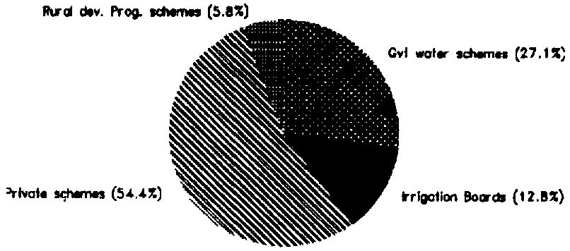
Four types of irrigation schemes can be distinguished in South Africa, according to the type of management (Figure 3):
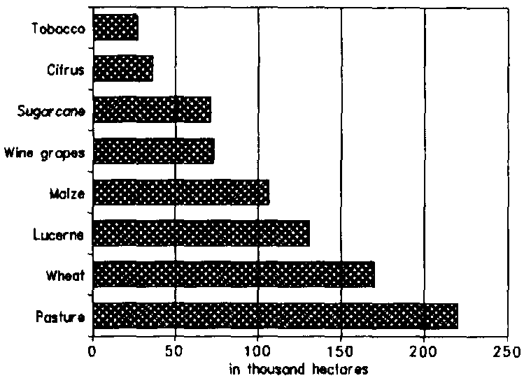
The main irrigated crops are pasture, wheat (with a yield of up to 6 t/ha), lucerne (11 t/ha), maize (up to 9 t/ha) and irrigated sugar cane (where yields ranging from 160 t/ha up to 210 t/ha have been obtained) (Figure 4).
FIGURE 3: Irrigation management
Subsidized subsurface drainage covers 54 000 ha. About 110 000 ha of irrigated land in South Africa is affected by waterlogging or salinization.
INSTITUTIONAL ENVIRONMENT
The Water Act of 1956 makes a legal distinction between private surface water - which belongs to the riparian land owner - and public surface water, the use of which is subject to various restrictions. Under the Water Act, Government Water Control Areas (GWCA) can be established to safeguard public water resources against overexploitation. Drought, increased demand and claims from neighbouring countries are factors contributing to the establishment of GWCAs. Another section of the Water Act prohibits the construction of private reservoirs larger than 250 000 m³ or diversion of discharge exceeding 110 l/s.
Two ministries are involved in water management and irrigation development:
The Water Research Commission (WRC) is a public institution which promotes, coordinates and funds water research.
TRENDS IN WATER RESOURCES MANAGEMENT
Irrigation development in the former homelands is constrained by communal land ownership, which results in lack of tenure security and limited access to land for the farmers.
Water demand projections indicated an annual growth of 1.5% between 1990 and 2010, ranging from 3.5 % for urban and industrial use to 1% for irrigation. The moderate predicted growth for irrigation is caused by low economic returns on irrigation water and, since 1984, the sharp increase in costs of irrigation equipment (20% per year) compared with a modest increase in agricultural produce prices.
FIGURE 4: Major irrigated crops (1988)
An increase in irrigation efficiency is necessary to overcome the reduction in water availability. Abolishment of the subsidised water charges would lead to an improved irrigation efficiency and a reduction of the area under low-value crops. Present government policy is to transfer as many Government Water Schemes as possible to IBs, with O&M costs fully paid by the farmers.
The reduction in water availability will probably result in an increase in conflicts over water allocation. For instance afforestation vs sugar cane in Natal; power generation vs irrigation in Eastern Transvaal; or conflicts between farmers in the developing sector and farmers in the commercial sector about the water quantity to be allocated.
MAIN SOURCES OF INFORMATION
Department of Agricultural Development. 1991. Spotlight on irrigation development in the RSA: the past, present and future.
Department of Water Affairs. 1986. Management of the water resources of the Republic of South Africa.
Directorate of Agricultural Trends. 1988. Agricultural statistics.
FAO. 1992. South Africa, Agricultural sector mission, Irrigation reconnaissance.
Water Research Commission. 1991. Researching and applying measures to conserve natural irrigation resources.
Water Research Commission. 1994. Irrigation development in southern Africa with special reference to South Africa.