GEOGRAPHY, POPULATION AND WATER RESOURCES
Sudan is situated in the northeastern corner of Africa and it is the largest African country, with a total area of about 2.5 million km². It shares common borders with nine countries. The cultivable area is estimated to be 105 million ha, or 42% of the total area, while the cultivated land is 7.6 million ha, or 3% of the total area and 7% of the cultivable area.
The population of Sudan is about 27 million (1994). The average population density is about 11/km², and the demographic growth rate is 2.8% per year. In 1990, 22.5% of the population were classified as urban and 77.5% as rural.
TABLE 1
Basic statistics and population
| Area of the country | 1995 | 250 581 000 ha |
| Cultivable land | 1995 | 105 000 000 ha |
| Cultivated land | 1995 | 7 600 000 ha |
| Total population | 1994 | 27 361 000 inhab. |
| Population density | 1994 | 11 inhab./km² |
| Rural population | 1993 | 78 % |
| Water supply coverage | ||
| Urban population | 1995 | 85 % |
| Rural population | 1995 | 35 % |
Some 80 % of the population works in the agricultural sector. The contribution of crop production to GDP was about 20% in 1991 (11% from irrigated and 9 % from rainfed crops).
Climate and water resources
The climate of Sudan varies from continental in the northern parts, through savannah in the centre, to equatorial in its most southern parts. Rainfall varies from 20 mm/year in the north to some 1 600 mm/year in the far south. The average annual rainfall is 436 mm, of which only 2.7% is transformed into surface water.
Water used in Sudan derives almost exclusively from surface water resources, as groundwater is used in only very limited areas, and mainly for domestic water supply. There are large areas in Sudan where exploitation of groundwater has been hampered by cost, as the water table is very deep. Internally produced water- resources are estimated at 35 km³/year global water resources at 154 km³/year Surface water is provided mainly by the Nile river. The main Nile is formed by the confluence of the Blue Nile (65%) and the White Nile (23%) in the capital Khartoum and receives, before flowing into Egypt, one more tributary, the Atbara river (12%). Both the Atbara and the Blue Nile rivers originate in the Ethiopian plateaus, while the White Nile originates from the Equatorial Lakes. Available average annual flow of the Nile is about 84 km³ at Aswan at the Sudano-Egyptian border, of which more than 80% occurs between August and October. According to the Nile water agreement between Sudan and Egypt, the Sudan's share is 18.5 km³/year, measured at Aswan, at the border with Egypt (20.6 km² at Semar, on the Blue Nile south of Khartoum). Apart from the Nile system, there are also the seasonal rivers of Gash and Baraka in eastern Sudan. During the rainy period of July-September, the water flow is very violent and drawn off into canals and spread over the land forming a very fertile delta area.
TABLE 2
Water balance
| Water resources: | |||
| Average precipitation | 436 | mm/yr | |
| 1 092.6 | km³/yr | ||
| Internal renewable water resources - total | 35.0 | km³/yr | |
| Internal renewable water resources - per caput | 1995 | 1 279 | m³/yr |
| Global renewable water resources | 154 | km³/yr | |
| Dependency ratio | 77.3 | % | |
| Total dam capacity | 1995 | 8.8 | km³ |
| De-salinated water | 1990 | 0 4 | 10 6 m³/yr |
| Water withdrawal: | |||
| - Agricultural | 1995 | 16 800 | 10 6 m³/yr |
| - Domestic | 1995 | 800 | 10 6 m³/yr |
| - Industrial | 1995 | 200 | 10 6 m³/yr |
| Total | 17 800 | 10 6 m³/yr | |
| per caput | 1995 | 651 | m³/yr |
| as a % of internal renewable water resources | 50.8 | % | |
| Other withdrawal | 1995 | 200 | 10 6 m³/yr |
| Wastewater: | |||
| Produced | - | 10 6 m³/yr | |
| Treated | - | 10 6 m³/yr | |
| Re-used treated wastewater | - | 10 6 m³/yr |
TABLE 3
Irrigation and drainage
| Irrigation potential | 1990 | 4 842 600 | ha |
| Irrigation: | |||
| 1. Full or partial control Irrigation: equipped area | 1995 | 1 900 000 | ha |
| - surface irrigation | - | ha | |
| - sprinkler irrigation | - | ha | |
| - micro-irrigation | - | ha | |
| % of area irrigated from groundwater | 1995 | 4.0 | % |
| % of area irrigated from surface water | 1995 | 96.0 | % |
| % of equipped area actually irrigated | 1995 | 63 | % |
| 2. Spate irrigation area | 1984 | 46 200 | ha |
| 3. Equipped wetland and inland valley bottoms | - | ha | |
| 4. Other cultivated wetland and inland valley bottoms | - | ha | |
| 5. Flood recession cropping area | - | ha | |
| Total water managed area (1 + 2 + 3 + 4 + 5) | 1995 | 1 946 200 | ha |
| - as a percentage of cultivated area | 1995 | 25.6 | % |
| - increase over last 10 years | - | % | |
| - power irrigated area as % of water managed area | 1984 | 37.3 | % |
| Full or partial control schemes: | Criteria | ||
| Large schemes | > - ha | - | ha |
| Medium schemes | - | ha | |
| Small schemes | < - ha | - | ha |
| Total number of households in irrigation | |||
| Irrigated crops: | |||
| Total irrigated grain production | 1988 | 533 000 | t |
| as a % of total grain production | 1988 | 22 | % |
| Harvested crops under irrigation | 1988 | 940 422 | ha |
| - cotton | 1988 | 324 240 | ha |
| - sorghum | 1988 | 298 620 | ha |
| - wheat | 1988 | 144 060 | ha |
| - groundnut | 1988 | 105 420 | ha |
| - other | 1988 | 68 082 | ha |
| Drainage - Environment: | |||
| Drained area | - | ha | |
| as a % of cultivated area | - | % | |
| Flood-protected area | - | ha | |
| Area salinized by irrigation | - | ha |
TABLE 4
Elements in the water balance of Sudan
| ELEMENTS | Average m³/yr | 80% reliable |
| 1. Water resources potential: | ||
| - Nationally generated surface water: | ||
| - Nilotic | 23 | 15 |
| - Other | 5 | 3 |
| - Groundwater recharge | 7 | 5 |
| Total internal renewable water resources | 35 | 23 |
| Nilotic tributaries at border | 117 | 102 |
| Other international streams | 2 | 1.7 |
| Global renewable water resources | 154 | 126.7 |
| 2. Currently available resources: | ||
| Net available surface runoff after losses | 86 | 70.9 |
| Nile watering | 20.6 | - |
| Other regional streams | 1.4 | - |
| Internally produced surface runoff | 0.7 | - |
| Groundwater | 0.7 | - |
| Total currently available water resources | 23.4 | - |
Note: (1) This figure takes into account the Sudano-Egyptian Treaty.
The water balance of Sudan is very complex, due in part to the extensive evaporation from the swamps, the best known being the Jonglei area on the White Nile. Furthermore, inter-annual variations in water resources greatly reduce the amount of water actually available for use. In Table 4, elements in the water balance of Sudan are presented, based on information from the Ministry of Irrigation and Water Resources, and including assessment of the 80%-reliable figures.
According to this water balance, total water lost by evaporation from swamps amounts to 68 km³/year It is calculated that the reclamation of part of the swamps could lead to an increase of 10 km³/year in surface water resources.
There are four large dams, two on the Blue Nile, one on the Atbara river, and one on the White Nile. The original storage capacity of the first three reservoirs was 5.7 km³ in total, but by 1990 had been reduced to 3.2 km³ due to ongoing siltation processes. Apart from the Jebal Aulia dam on the White Nile, which serves mainly to regulate the Nile flow, the other dams serve both as flood control structures and for irrigation.
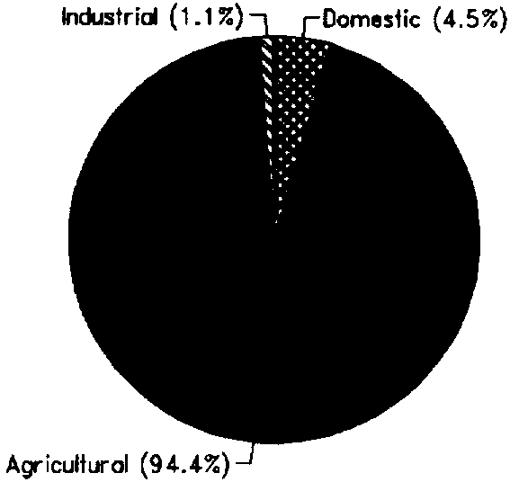
Total water withdrawal is estimated at 17.8 km³ (1994) (Figure 1).
IRRIGATION DEVELOPMENT
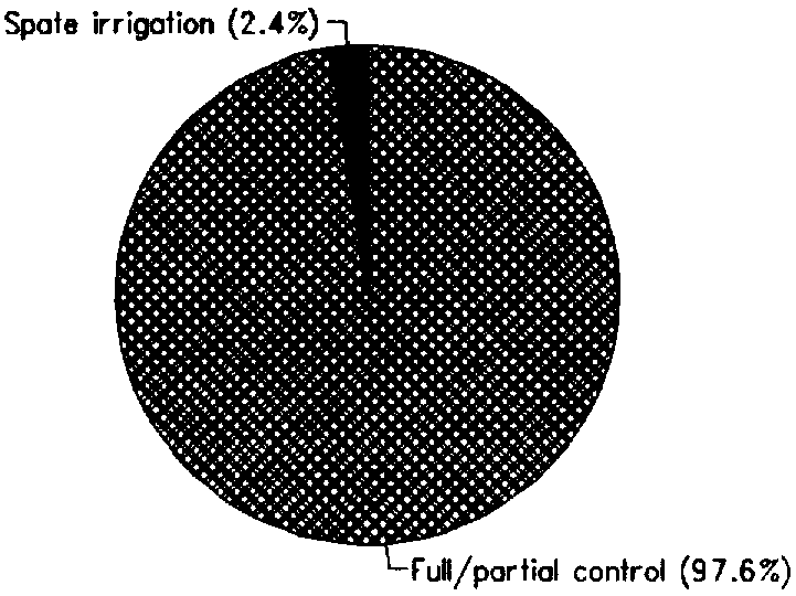
Agriculture, and especially crop production, is the most significant element in Sudan's economy. Most of the cash crops are produced by irrigation, and irrigated agriculture produces about 50% of the total crop production. Sudan has an irrigation potential of about 4.8 million ha, while the Total water managed area is around 1.95 million ha, or 26% of the cultivated area. However, the development of the additional 3 million ha is constrained both by limited storage capacity and shortage of water. Some 46 200 ha is under spate irrigation in the Gash and Tohar deltas; the rest are full or partial control irrigation schemes (Figure 2). All irrigation water comes from surface water.
Most schemes are large-scale schemes, which are managed by parastatal Agricultural Corporations (ACs), while small-scale schemes are owned and operated by individuals or cooperatives. The combined Gezira-Managil scheme constitutes probably the largest irrigation complex in the world (about 760 000 ha).
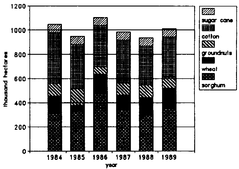
Although irrigated agriculture has been Sudan's greatest economic investment, returns have been much below potential. A study by the World Bank showed that, during the period 1976-1989, yields were low and extremely variable, and cultivated areas suffered gradual decline. Cropping intensity in the Gezira Scheme, dropped from 75% to 57%, as 126 000 ha were taken out of production due to siltation and mismanagement of the canals, leading to reduced availability of water. The new government in Sudan reports that since 1990 there has been considerable improvement in agricultural crop production and returns. Major irrigated crops are cash crops (cotton, groundnut, sugar), wheat and sorghum (Figure 3).
FIGURE 1: Water withdrawal (total: 17.8 km³ in 1994)
FIGURE 2: Distribution of the water managed areas (1990)
FIGURE 3: Major irrigated crops (1988)
INSTITUTIONAL ENVIRONMENT
Since independence in 1956, Sudan has established a well developed institutional infrastructure in an attempt to make its irrigation sector more efficient. At the top, the National Nile Waters Commission determines the allocation of water to each province. The Ministry of Irrigation and Water Resources (MOI&WR) is responsible for delivery of irrigation water to the major canals and, jointly with the Agricultural Corporations (AC), for the operation of minor canals. MOI&WR is the sole authority for surface water resources assessment and development in Sudan, whereas the Groundwater Corporation has the same responsibility regarding subterranean water resources. The Hydraulic Research Station (HRS) of MOI&WR deals with the development of theoretical and applied research concerning surface water resources. Regarding domestic water supply, the responsibility for its management and development is divided between The Urban Waters Corporation and The Rural Waters Corporation.
TRENDS IN WATER RESOURCES MANAGEMENT
Under the reforming policies of the post-1989 government in Sudan, development of irrigated agriculture has become a crucial element. There are ongoing studies for expansion and rehabilitation of irrigation projects. Also, the construction of new hydraulic structures, such as dams and major irrigation canals, are an essential part of the planned development. Important projects include the heightening of Roseires dam, the excavation of two major canals for water diversion from the Blue Nile, and the construction of Merawi dam in the northern part of the country. Further irrigation development is limited by the amount of water allocated by the Nile Water Agreement with Egypt.
Three major constraints to irrigation development in Sudan are that:
MAIN SOURCES OF INFORMATION
Abdelsalam A. 1991. Sedimentation in Sudan Multipurpose Reservoirs. Internal Publ. Hydraulic Research Station-Sudan.
ICID. Unpublished. General comments on water resources and water use in Sudan [1995].
World Bank. 1990. Sudan - Reversing the Economic Decline. Country Economic Memorandum.