Back to contents - Previous file - Next file
2.1. The basis
2.2. An
example
Caesium-137 is an artificial radionuclide with a half-life of 30.17 years which was produced as a by-product of past atmospheric testing of thermonuclear weapons. The radiocaesium was released into the stratosphere, distributed globally and deposited as fallout, usually in association with precipitation. Its value as a sediment tracer lies in its rapid and strong adsorption by soil particles, particularly the clay fraction [8-10], so that in most agricultural environments its subsequent redistribution is a direct reflection of the erosion, transport and deposition of soil particles
occurring during the period extending from the main phase of atmospheric deposition (late 1950s and early 1960s) to the time of sampling. Where cultivation occurs, the radiocaesium will be distributed throughout the plough layer, and soil redistribution will generally involve a relatively small proportion of the original total fallout inventory. Where, however, soils are essentially undisturbed, as in the case of permanent pasture and rangeland, radiocaesium will be preferentially concentrated near the surface, and a given rate of soil redistribution will involve a substantially greater proportion of the original inventory. Assessment of 137Cs redistribution is commonly based on comparison of the measured inventories (total activity per unit area) at individual sampling points, with an equivalent estimate of the inventory representing the cumulative atmospheric fallout at the site, taking due account of the different behaviour of cultivated and non-cultivated soils. Because direct long term measurements of atmospheric fallout are rarely available, the cumulative input or reference inventory is usually established by sampling adjacent undisturbed, uneroded locations, generally under permanent pasture, which can provide an estimate of total fallout inputs. Where sample inventories are lower than the local reference inventory, loss of caesium labelled soil and therefore erosion may be inferred. Similarly, sample inventories in excess of the reference level are indicative of the addition of caesium labelled soil by deposition. The magnitude and direction of measured deviations from the local reference level provide a qualitative assessment of sediment redistribution.
To derive quantitative estimates of the rates of soil erosion and aggradation from 137Cs measurements, it is necessary to establish a relationship between the magnitude of the deviation from the reference inventory and the extent of soil loss or gain [11]. Because empirical calibration data are rarely available, many workers have favoured the use of theoretical relationships or models to provide the necessary calibration function. Such models can be used to simulate the effect of a range of long term erosion and aggradation rates upon the 137Cs inventory of soil profiles, and the resultant data can be used to derive the calibration relationship [11].
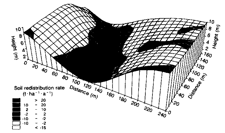
Figure 1 provides an example of the potential for 137Cs measurements to assemble detailed information on the medium term (i.e. about 35 year) pattern of soil redistribution within a 3.8 ha agricultural field at Rufford Forest Farm, Nottinghamshire, United Kingdom, reported by Walling and Quine [7]. This area, which is underlain by brown sand soils of Cuckney I association, is primarily used for arable cultivation. Sugar beet is widely grown and soil erosion has frequently been observed in the area [12]. A 20 m x 20 m grid was used as a basis for collecting soil cores from the field and a total of 117 cores was obtained using a motorized percussion corer (38 cm²) inserted to a depth of 60 cm. The reference cores were obtained from an area of uneroded, undisturbed grassland located 1.7 km from the study field. After collection, all the cores were air dried and lightly ground and the 137Cs content of the material passing through a 2 mm sieve was determined by gamma spectrometry using an HpGe coaxial detector. All the values were converted to areal inventories (mBq/cm²) and a value of 320 mBq/cm² was obtained for the local reference inventory. Deviations of the inventories associated with the individual sampling points within the field, from the reference value, were subsequently established, and estimates of the medium term rates of erosion and deposition occurring within the field over the past 35 years were derived using a calibration model. The resultant pattern of soil redistribution documented for the field, which is presented in Fig. 1, reflects the action of a range of erosion processes, including both water erosion and the effects of soil tillage.
TABLE I. SPATIALLY INTEGRATED ESTIMATES OF SOIL REDISTRIBUTION IN THE FIELD AT RUFFORD FOREST FARM, AS ILLUSTRATED IN FIG. 1
| Gross erosion rate (t ha(-1) a(-1)) | 12.2 |
| Eroding zone | |
| Mean erosion rate (t ha(-1) a(-1)) | 13.8 |
| % of total area | 89 |
| % of area with erosion rates: | |
| >2 t ha(-1) a(-1)) | 81 |
| >4 t ha(-1) a(-1)) | 72 |
| Aggrading zone | |
| Mean aggradation rate (t ha(-1)a(-1)) | 16.1 |
| % of total area | 11 |
| Net erosion rate (t ha(-1) a(-1)) | 10.5 |
| Sediment delivery ratio (%) | 86 |
In addition to providing an assessment of the spatial pattern of soil redistribution within the study field, the individual point estimates of the erosion and deposition rates based on the 137Cs measurements can be spatially integrated to produce a range of measures of the overall status of erosion and deposition in the field (Table I). The values of both the gross erosion rate and the mean erosion rate for the eroding sites permit clear assessment of the severity and potential on-site impact of erosion within the area under investigation. Furthermore, assessment of both the net soil loss and the sediment delivery ratio permits evaluation of the offsite threat posed by sediment leaving the field and potentially entering local watercourses.
The example outlined above is based on measurements of the total inventory of individual soil cores, since this minimizes the number of samples requiring gamma assay and therefore reduces the costs involved. Further development and refinement of the approach could involve consideration of the depth distribution of caesium in the soil profile, since information on both the maximum depth to which radiocaesium occurs relative to the plough depth or the original undisturbed profile, and the shape of the radiocaesium profile, can provide the basis for improved interpretation of the erosional history of the study site, particularly in areas of intensive land use [13].
The information generated for the field at Rufford Forest Farm on the basis of 137Cs measurements (Fig. 1 and Table 1) represents essentially unique data which are effectively impossible to obtain by any other means. Use of erosion plots would, for example, only provide information on the net soil flux at the lower end of the bounded plot and would be unable to document the spatial pattern of erosion and deposition within the field. Equally, they would be unable to provide information on the effects of soil redistribution by tillage. Furthermore, although the medium term, temporally lumped, nature of the erosion rate estimates could be seen as a limitation, it must be recognized that short term measurements could be unrepresentative and that intensive long term monitoring is likely to be both costly and labour intensive, and in many cases impractical. In addition, the 137Cs approach affords a unique opportunity to obtain retrospective information for a particular site and to acquire the spatially distributed data required to develop and validate the new generation of distributed soil loss models currently being developed. These and other key advantages of the use of 137Cs to monitor the rates and patterns of soil loss are summarized in Table II.
TABLE 11. KEY ADVANTAGES OF THE USE OF 137Cs MEASUREMENTS TO MONITOR THE RATES AND PATTERNS OF SOIL LOSS
| (1) | The estimated erosion rate represents the sum of all the erosive processes, includingboth water erosion and tillage |
| (2) | The whole field may be studied without disturbance to the slope environment |
| (3) | The technique is capable of providing a quantitative measure of both the spatial distribution and the rate of soil erosion, and the proportion of eroded soil that is transported beyond the field |
| (4) | The erosion rate estimates obtained represent the average values for the past 30-35 years and are therefore less influenced by the timing of extreme events relative to the period of measurement |
| (5) | The information obtained is retrospective |
| (6) | Only a single site visit to each study site is required |