![]()
![]()
![]()
1.1 Coral reefs
1.2 Carrying capacity
1.3 Objectives of the study
1.4 Background information on Pulau Payar Marine Park
A coral reef ecosystem consists of an assemblage of a variety of plants and animals in tropical waters where corals form the dominant components. Hard corals, which form the most visible part of a reef, are constructed by minute marine animals called coral polyps that secrete a calcium carbonate exoskeleton around themselves. They do this by precipitating calcium ions from the sea water. The polyps sub-divide as they grow, and form complex coral colonies which are made up of millions of polyps fused together by their skeletons. In addition to corals, coralline algae also produce limestone skeletons and help build and consolidate coral reefs.
The polyps of true reef-building or hermatypic corals contain unicellular dinoflagellates called zooxanthellae within their tissue, and this symbiotic association is mutually beneficial. The zooxanthellae use the sun's energy to photosynthesise, providing food for themselves and the coral polyps, thus enhancing the production of the calcium carbonate skeletons and the coral structures. The polyps themselves normally remain in their skeletons during the day, and feed at night using tentacles to capture their prey which subsequently filter into their stomachs. They can also absorb dissolved food from the water.
Coral reefs flourish in the warm shallow waters of tropical seas that optimally have temperatures between 26°C and 27°C (Wells & Price, 1992). The shallow waters allow sufficient light penetration for the zooxanthellae and other primary producers to photosynthesise. They need constant high salinity and pollution-free waters to thrive. There is an estimated 600,000 km2 of coral reefs worldwide, 25-30% of which are located in South East Asia. Malaysia has coral reefs on both the East and West coasts of the Peninsula, as well as off Sabah and Sarawak.
Coral reefs are amongst the most biologically diverse and productive ecosystems on Earth. Associated with coral reefs are a myriad of organisms; fish and invertebrates, especially molluscs, crustaceans and echinoderms predominate, and algae are also abundant. Coral reefs are the feeding, breeding and nursery grounds for many fish and invertebrate species, many of which are commercially important. They are thus crucial for supporting the fisheries sector, and it has been estimated that reef fisheries have the potential to contribute approximately 12 per cent of all fish caught annually throughout the world (Wells & Price, 1992).
Coral reefs act as a natural protection between the open seas and coastlines by acting as wave breaks, thus effectively preventing coastal erosion. They may also perform a vital role in protecting coastal areas from the consequences of predicted sea level rise such as storm flooding (Markham et al, 1993). Furthermore, there is increasing evidence of the potential of reefs to act as bio-indicators for climate change, as they are sensitive to sea level rise and sea temperature. In addition, reefs are good indicators of coastal pollution, as they are sensitive to changes in their ambient environment.
Coral reefs are also a potential storehouse of medicinally valuable species, many of which have yet to be discovered. Several reef-dwelling organisms have been found to produce highly active biochemical compounds with antibiotic, antileukumic, anticoagulant and cardioactive properties (De Silva & Ridzwan, 1982). In addition, reef-related tourism such as SCUBA diving and snorkelling plays an important role in the economies of many countries. Nevertheless, exploitation of reefs for tourism purposes must be sustainable, and be appropriately managed to ensure that the reefs are not damaged.
Coral reefs are thus extremely beneficial to humankind, providing a variety of ecological and physical services which are also economically important. Box 1.1 presents a brief summary of these benefits. The productivity of a coral reef relies upon an intricate recycling process that passes nutrients through the ecosystem via a complex web of food chains. Unfortunately this characteristic means that a reef is vulnerable, and its finely balanced ecosystem can be easily disrupted by anthropogenic activities. As such, the conservation and protection of coral reef ecosystems are becoming increasingly urgent efforts, crucial to ensure that we do not lose their intrinsic values and resources.
BOX 1.1 BENEFITS OF CORAL REEFS
|
· Biologically diverse and productive · Feeding, breeding and nursery grounds for many fish and invertebrate species, thus supporting the fisheries sector · Natural protection between the open seas and coastlines · Act as wave breaks and prevent coastal erosion · Protect coastal areas from the consequences of predicted sea level rise · Potentially act as bio-indicators for climate change · Indicators of coastal pollution · Potential storehouse of medicinally valuable species yet to be discovered · Reef-related tourism plays an important role in the economies of many countries |
1.2.1 Definition of carrying capacity
1.2.2 Coral reef carrying capacity
1.2.3 Determinants of reef carrying capacity
The concept of carrying capacity is one which exemplifies the need to maintain development and activities at a level that is both ecologically and socially sustainable. It is related to the concept of resilience, and implies that there are limits, or thresholds, beyond which a system will not facilitate further changes or increase (Getz, 1982). This concept is increasingly applied to tourist destinations following the realisation that these places have a certain 'carrying capacity', that is, a level of tourist and recreation development and activities beyond which environmental degradation occurs, facilities become saturated, or visitor enjoyment diminishes (e.g. Hovinen, 1982; Mathieson & Wall, 1982). The concept of a tourist destination having a carrying capacity thus embodies the assumption that eventually, a threshold will be reached after which the destination will be decreasingly desirable.
Birthed from the study of animal populations, the carrying capacity concept now goes beyond estimating mere numbers; it has increasingly evolved as a planning and management tool to enable planners and managers to determine, not, "How much is too much?", but rather, "How much change is acceptable?" (Williams & Gill, 1991). As any human use of the natural environment inevitably results in some change to that environment, the focus would be to identify how much change is acceptable for a given setting (Stankey & McCool, 1992). The concept thus stresses the management of desired environmental and social conditions, which can be expressed using the Limits of Acceptable Change (LAC) planning system (Stankey & McCool, 1984). For carrying capacity to be a useful tool for tourism planning and management, it should not be approached in a mechanistic manner (i.e. trying to determine a "magic number"), but should rather be seen as a means of identifying thresholds that require attention, and as an optional form of controlling the system through the imposition of partial or complete limits (Getz, 1983). The traditional concept of carrying capacity is not without its limitations, and is modified here to highlight actions that may be taken to minimise or limit adverse anthropogenic impacts on the coral reef environment. While recognising the limitations of the traditional carrying capacity concept, the concept can be used to help identify factors that impact negatively on the marine environment, and to generate management recommendations that may alleviate the tourism pressure on reefs. The focus is thus to highlight possible actions that may be taken to minimise or limit adverse impacts on the coral reef environment.
Carrying capacity can be broken up into its fundamental components of ecological, physical, social and economic carrying capacities. Nonetheless, the estimation of carrying capacity or limits of acceptable change is not an easy task, as many factors operate. Furthermore, there is no set method or formula available, and each case study should be viewed separately. For further information on the concepts and analysis of carrying capacity, please refer to Lim (1995a & 1995b). A framework guideline based on Lim's (1995a) recommendations is presented in Appendix 1.
A carrying capacity that needs to be established for Pulau Payar Marine Park is the tourism carrying capacity, that is, its capacity to accommodate visitors and development without detrimentally affecting the marine environment and its resources, or effecting a decline in visitor satisfaction (WTO & UNEP, 1992). Carrying capacity for tourist destinations implies that there is a limit to the amount of tourism development and activity that can occur in an area, beyond which facilities are saturated, visitors become dissatisfied and environmental degradation occurs. Tourism carrying capacity can be further broken down into its fundamental components of ecological or environmental, physical, social and economic carrying capacities.
The physical carrying capacity is the threshold limit for space, beyond which facilities are saturated (Getz, 1982). The social carrying capacity can be looked at from two perspectives; one is the capacity of the host population to tolerate the presence of tourists, the second is the level at which visitor enjoyment diminishes and dissatisfaction sets in (O'Reily, 1986). Graefe et al (1984) define social carrying capacity further as "the level of use beyond which experience parameters exceed acceptable levels specified by evaluative standards". Economic carrying capacity is the level at which tourism interference with non-tourism activities becomes economically unacceptable.
The coral reef ecosystem is extremely vulnerable to changes in the environment. Globally, reefs are now receiving increasing pressure from both the expansion of reef tourism, and land-based activities. The concept of carrying capacity can be utilised for reef ecosystems to identify reef capacity determinants, and subsequently for the reduction or elimination of the causes of damage. This approach, if appropriately applied during the planning and management stages of coastal and marine resources use, can effectively raise reef carrying capacity (Salm, 1986) to an acceptable level, enabling the reef to be used for recreation purposes without compromising its ecological integrity.
The carrying capacity of one reef vis-à-vis other reefs should be looked at within the scope of a broader management strategy. Therefore overall reef carrying capacity is not determined on the basis of one reef and its individual factors alone but would depend on a variety of other interlinked factors.
Reef carrying capacity can be further examined from the perspectives of ecological, physical and social carrying capacities. The ecological carrying capacity of the reef is the threshold limit for visitor use and consequent incidental damage that the coral reef ecosystem can sustain without being degraded. Furthermore, coral reefs are only able to tolerate a certain amount of change in ambient qualities, and factors such as pollution, siltation and exploitation affect them adversely. Nevertheless, reef ecological carrying capacity is difficult to establish; this is an aspect of carrying capacity that would require in-depth long-term study of the reef ecosystem, which was not possible to do in this instance. The physical carrying capacity of the reef relates to the availability of boats which ferry divers and snorkellers to the reefs, as well as the number of mooring buoys available; space on the reef is also considered. The size and shape of the reef, as well as the composition of the coral communities also determine physical carrying capacity. The social carrying capacity of the reef is the limit to visual contact between divers and snorkellers beyond which they become dissatisfied (Salm, 1986).
The concept of carrying capacity can be utilised for reef ecosystems to identify reef capacity determinants, and subsequently enables the reduction or elimination of the causes of damage. In addition, proper management will help ensure that user-related damage is controlled and minimised.
Reef capacity determinants are discussed briefly as follows:
(a) Size and shape of the reefLarge reefs can accommodate more divers and snorkellers than small ones (Salm, 1986). Divers or snorkellers swimming over uniform flat shallow reefs are limited in opportunities because of the homogenous nature of the coral communities. Movement is unrestricted and group interaction potentially higher; consequently social carrying capacity is easily reached. If there are irregularities in the reef morphology such as outcrops, these will restrict movement and act as screening between groups. At the same time, the irregularities present more options to explore and thus increase interest. The reef users will cover less reef area and group contact will be reduced; consequently from the perspective of inter-group contact, irregular reefs have a higher carrying capacity (Salm, 1986).
(b) Composition of coral communities
Reef use will almost certainly cause damage, but the extent of damage largely depends on the fragility of the coral colonies and the percentage of live corals present (Salm, 1986). Branching or foliose corals are more likely to be broken by careless divers and snorkellers, or anchors, than massive coral. Damage is also more obvious if there is a high percentage of coral cover. Therefore, reefs consisting mainly of live coral intrinsically have a higher carrying capacity. Reefs composed of large areas of soft corals also attract divers and snorkellers, but they are more resilient and can accommodate more physical contact. Soft corals tend to be flexible and less susceptible to physical damage.
(c) Depth, currents, and visibility
If a reef is deep and/or has a strong prevailing current, it will not be as "user-friendly" to the average diver, and will immediately have a higher carrying capacity. Dive operators tend to initially visit the shallower reefs, and if there is little or no current running it will be easier for a Dive Master to control a large group. Poor visibility may reduce diver satisfaction but it can also increase social carrying capacity by limiting visual interactions between diving groups, especially on popular reefs.
(d) Level of experience of snorkellers and divers
The level of experience of divers can affect the carrying capacity of the reefs. Novice divers frequently stand on corals to rest, or blunder against them, and thus are more likely to damage fragile reef structures. In comparison, more experienced divers would have better buoyancy control and spatial awareness, as well as a greater understanding of the reef ecosystem and its fragility. When diving is carried out through a dive operator it is possible for the Instructor or Dive Master to decide upon the dive site depending on the experience of the members of the group. Novice divers should preferably be confined to reefs with boulder type corals, rocks, and scattered live corals, or to the sandy periphery of reefs and the gullies through them where they can do less damage (Salm, 1986).
(e) Accessibility
This is determined by the distance of a reef from the dive shops, or ease of location (locating a submerged patch reef can be a problem). If a reef is not marked by moorings or marker buoys, then local knowledge or a GPS will be required. Locating a reef in this way involves the risk of missing the site altogether, something that a dive operator with paying divers cannot afford to do. This implies that a reef can have a relatively high carrying capacity simply by being difficult to locate.
(f) Attractions
An aesthetically pleasing reef with interesting marine life will automatically have a lower carrying capacity, particularly if it is easily accessible, as popularity would put increasing pressure on the reef. Attractions include diverse hard corals, colourful soft corals, large fish, large schools of fish, turtles, sharks, manta rays and swim-throughs (underwater tunnels). Frequent visitation will mean an increased likelihood of physical damage to the reef and a shortage of moorings which can lead to anchoring problems.
In December 1994, the waters off 38 islands in Malaysia were gazetted as Marine Parks Malaysia, 35 of which are in Peninsular Malaysia. However, in Peninsular Malaysia, gazettement only affords protection to the offshore waters, while land on Marine Park islands may be still subjected to intense development, since the Establishment of Marine Parks Malaysia Order 1994 only affords protection to the waters up to two nautical miles off the islands. This is due to a constitutional difference in jurisdiction; land matters come under the purview of the respective State governments whereas offshore waters are under Federal jurisdiction. Integrated management of Marine Park islands is thus essential, whereby land use on these islands is properly planned, and both marine and terrestrial ecosystems are managed as a whole. These concerns culminated in a joint Department of Fisheries Malaysia-World Wide Fund for Nature (WWF) Malaysia report, "Marine Park Island Management Conceptual Plan for Peninsular Malaysia" (Aikanathan & Wong, 1994).
Amongst land-based activities, increasing tourism development of the inappropriate kind on Marine Park islands is bringing about degradatory impacts on the marine environment. One of the most consequent problems is that of pollution due to land-based activities. A WWF Malaysia report on "Tourism, Pollution and the Marine Environment in Malaysia" (Lim, 1996) identified the sources, types, impacts and contributory factors to marine pollution from island and coastal tourism, as well as the proposed practices to deal with these problems.
One of the best practice planning and management tools which was advocated vis-à-vis tourism is the concept of "carrying capacity" (Lim, 1995a) (see Section 1.2 for a more detailed discussion). An assessment of carrying capacity or the limits of acceptable change can contribute towards better planning and management of tourist destinations. The National Ecotourism Plan, in Part 3: Ecotourism Guidelines for Malaysia, advocates the use of the carrying capacity concept in preparing development and management plans for a tourism area, especially protected areas (MOCAT/WWF Malaysia, 1996).
The Pulau Payar Marine Park, located off the west coast of Peninsular Malaysia, consists of Pulau Payar, Pulau Lembu, Pulau Kaca and Pulau Segantang. These islands are uninhabited, and are surrounded by diverse coral reefs and associated marine life. However, the Pulau Payar Marine Park is receiving increasing pressure from tourism, with visitor numbers swelling to worrying levels (from 1,373 visitors in 1988 to over 70,000 in 1995). This increase in tourist numbers poses a risk of detrimental impacts to the marine environment, through direct impacts of reef-related tourism and through pollution from tourism. Consequently, visitor dissatisfaction can have a negative impact on the tourism industry itself. It is therefore necessary for management to determine how much change is now acceptable and to manage visitors accordingly.
The Department of Fisheries Malaysia, under the auspices of the FAO/UN's Bay of Bengal Programme, is formulating a Special Area Management Plan (SAMP) for the Pulau Payar Marine Park, amongst other studies in the region. It was proposed that an assessment of Pulau Payar Marine Park's carrying capacity be carried out based on the framework guidelines set out in Lim (1995a & 1995b) (see Appendix 1), as a component of the support material for the SAMP. This study, in assessing carrying capacity, would thus attempt to address crucial issues such as the need for integrated management of Pulau Payar Marine Park specifically, and Marine Park islands generally, as well as recommend best practices in controlling and minimising negative impacts from tourism, drawing from previous work carried out by WWF Malaysia as mentioned above.
The impacts of land-based activities and tourism on the marine and island environment are extensive, from an ecological, physical, social and economic point of view. The scope of the study was limited to looking at the physical and social carrying capacities of Pulau Payar Marine Park. Host social carrying capacity was not looked at in this instance, as the study focused mainly on the Marine Park itself where no local communities reside. Although it would be important to look at host tolerance and perception of tourism in surrounding areas such as Pulau Langkawi, Kedah and Perlis, it was not within the scope of this study to do so. Nor was it within the scope of this study to look at economic carrying capacity. Furthermore, while recognising the limitations of the traditional carrying capacity concept, the concept is used here to help identify factors that impact negatively on the environment of Pulau Payar Marine Park, and to generate management recommendations that may alleviate the tourism pressure on its reefs. The focus of the study is thus to highlight possible actions that may be taken to minimise or limit adverse impacts on the coral reef environment.
There were two major components of the study. The marine aspect aimed at obtaining general baseline data for some of the more popular coral reefs. These included assessing coral cover and composition, and identifying some of the key threats faced by the reefs, in order to identify reef capacity determinants. The land-based survey aimed at identifying the main tourist attractions of the Pulau Payar Marine Park and estimating its capacity with regard to tourists arrivals and visitor satisfaction.
It is hoped that the study will lead to recommendations for the effective management and planning of the Pulau Payar Marine Park with regard to tourism. With visitor numbers exceeding 70,000 in 1995, there needs to be a management decision on an acceptable maximum number of visitors over a year, such that the natural assets of Pulau Payar Marine Park are not degraded or destroyed consequently. The integration of the carrying capacity concept in future planning stages of tourism development in Pulau Payar is needed to ensure the well being and long-term sustainability of the island's valuable yet vulnerable marine ecosystem.
1.4.1 Location and geography
1.4.2 Marine resources
1.4.3 Historical use
1.4.4 Tourism in Pulau Payar Marine Park
1.4.5 Pulau Payar as a Marine Park
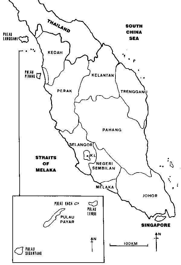
The Pulau Payar Marine Park is situated off the state of Kedah, between Pulau Langkawi and Pulau Pinang, at 6°02' - 6°05'N and 99°54' - 100°04'E (Map 1). The distances from its three common access points, Kuala Kedah, Pulau Langkawi and Pulau Pinang, are 15 nm, 19 nm and 32 nm, respectively. The Marine Park consists of a group of four islands - Pulau Payar, Pulau Kaca, Pulau Lembu and Pulau Segantang. They are under the administrative jurisdiction of the Pulau Langkawi District Council.
Pulau Payar is the largest of the islands, with an area of 31.2 hectares and an approximate length of 1.75 km (Aikanathan & Wong, 1994). The entire length of its north-western coast is predominantly rocky and characterised by steep cliffs and wave-cut gullies. There are four sandy beaches on the island, two of which are approximately 100 - 150 m long. There are very few low-lying areas on the island as it rises at a steep gradient from the shore. The entire island is covered with dense vegetation.
Pulau Kaca is approximately 0.4 nm to the north-east of Pulau Payar. The island is a conglomerate of rocky boulders with sparse vegetation, and an approximate area of 1.8 hectares (Aikanathan & Wong, 1994). It attains a height of approximately 10 m above sea level (De Silva & Ridzwan, 1982).
Pulau Lembu is situated to the east of Pulau Kaca and is about 0.75 nm north-east of Pulau Payar. It is 0.75 km long and has an area of 6.9 hectares. It is thickly wooded, uninhabited and rises sharply from the shore to a height of about 70 metres (De Silva & Ridzwan, 1982). There is one small beach on the south-eastern facing side of the island.
Pulau Segantang is about 6.7 nm south-west of Pulau Payar and is made up of two rocky outcrops which are joined together underwater. The larger outcrop is approximately 200 m to 250 m long and about 50 m wide, while the smaller outcrop is approximately 50 m in length and 40 m in width (De Silva & Ridzwan, 1982). Scattered vegetation can be found on both outcrops.
The Pulau Payar group of islands constitutes one of the few coral reef areas found off the west coast of Peninsular Malaysia and a wide variety of habitat types are found within a relatively small area. In the early 1980's, 35 hard coral genera, 92 other marine invertebrates and 45 genera of fish, some of them commercially important, were recorded in the area (De Silva & Ridzwan, 1982).
Major coral genera reported include Acropora, Montipora and massive corals such as Porites, Platygyra, Goniopora, Diploastrea and Plerogyra (Aikanathan & Wong, 1994). Smaller coral colonies such as Galaxea, Pocillopora, Pavona, Hydnophora, Favia as well as the mushroom corals Fungia and Herpolitha were found dispersed among the large coral (De Silva & Ridzwan, 1982).
Common fish life recorded include barracuda (Sphyraena sp.), groupers (Epinephelus sp. and Promicrops sp.), rabbit fish (Siganus oramin), fusiliers (Caesio chrysozonus and C. erythrogaster), sergeant-majors (Abudefduf saxatilis) and snappers (Lutjanus lineolatus) (De Silva & Ridzwan, 1982).
MAP 1: Peninsular Malaysia and Pulau Payar
Traditionally, before the Pulau Payar group of islands were gazetted as a Marine Park, their surrounding waters were important fishing grounds for fishermen based in Kuala Kedah. Fishing activities that were carried out around the islands include drift netting, purse-seining, long-lining and bottom traps (Aikanathan & Wong, 1994). Pulau Payar itself has in the past been a sheltering place for fishing vessels, particularly during the monsoon period. In addition, rock oysters used to be harvested from Pulau Payar, Pulau Lembu and Pulau Kaca on a yearly basis up until the Marine Park Centre was established (De Silva & Ridzwan, 1982).
In the past, logging activities were also carried out on Pulau Payar, as evident from the abandoned logs observed both on the beach and underwater during an earlier survey (De Silva & Ridzwan, 1982).
In recent years, especially since the gazettement of the Marine Park, Pulau Payar has been expanding rapidly as a tourist destination, with visitor numbers increasing dramatically over the years. This can be attributed largely to the rapid development of the tourism sector of Pulau Langkawi as a major tourist centre for the northern region of Peninsular Malaysia. In addition, Pulau Langkawi is being promoted worldwide as a tourist destination. A visit to the Pulau Payar Marine Park is often included in package tours or sold separately as a day trip from Pulau Langkawi.
Pulau Langkawi is a tourist attraction in its own right, and is the main island in a group of 104 islands in the northern part of the Straits of Melaka. It is an island of legends, the most well-known being that of Mahsuri, who when accused of a crime she did not commit, cursed the island for seven generations in her dying breath. Pulau Langkawi now has a booming tourism industry, much of it due to its natural beauty and beaches, sites of historical and legendary interest as well as its duty-free status.
Pulau Payar is in many instances considered as part of the Pulau Langkawi visitor package. Other islands around Pulau Langkawi which are also popular tourist destinations are Pulau Singa, Pulau Dayang Bunting and Pulau Beras Basah; some tour operators include these islands as part of an island hopping package, Pulau Payar Marine Park inclusive. However, these other islands do not have reefs comparable to that of the Marine Park, making Pulau Payar the first choice for a snorkelling or diving experience.
The promotion of Pulau Payar as a tourist destination is very strongly linked to that of Pulau Langkawi. Pulau Langkawi has been aggressively promoted overseas and coupled with the boom in tourist arrivals during Visit Malaysia Year 1990 and Visit Malaysia Year 1994, this has led to the island making its mark on the global tourist map. A package tour to Pulau Langkawi usually includes a visit to Pulau Payar Marine Park. For example, a visit to Pulau Payar is the main tourist attraction of Pulau Langkawi for the Japanese market. As such, promotion is carried out overseas as well, mainly by the Langkawi Development Authority (LADA). The Kedah State Economic Planning Unit (UPEN Kedah) tends to focus more on promoting Pulau Langkawi and Pulau Payar among domestic tourists. The promotion of Pulau Payar emphasises its marine environmental attributes, and is sold as a Marine Park with some conservation emphasis.
Pulau Payar itself is a small island with very few low-lying areas and beaches, as the land rises at a steep gradient from the shore. Coupled with the lack of freshwater sources on the island, this seems to have deterred any accommodation development on the island. The Marine Park Centre occupies a small area of 0.6 hectares and the existing beach, already limited in space, is made smaller by a picnic area with tables and chairs (Plate 1). The other islands are mere rocky outcrops, so any type of development there is out of the question. Since there are no accommodation facilities on Pulau Payar, the overwhelming majority of visitors are day trippers. Occasionally, visitors may camp on the island, but given the lack of basic facilities such as water supply, these are few and far between.
PLATE 1: Pulau Payar Marine Park Centre
Photo: WWFM/Li Ching Lim
Visitor permits to enable entry into Pulau Payar Marine Park are issued by the Department of Fisheries from Pulau Langkawi, Pulau Pinang, Kuala Kedah and Alor Setar. These have to be obtained by tour or dive operators prior to coming to Pulau Payar Marine Park, and along with a list of guest names and nationalities, are surrendered to Marine Park staff on arrival at the Marine Park Centre. Thus far, there are no limits to the issuance of permits, so long as the number of passengers per boat does not exceed the limit imposed by the Marine Department (12 passengers a boat). There are also no limits to the number of boats that can come in to the Marine Park per day; these vary with demand. Permits also have to be obtained for overnight camping, and there is a physical limit of 30 campers at any one time.
Sri Wani Holdings, through its subsidiary Langkawi Coral, operates a 50 m x 15 m floating pontoon which is moored off the beach south of the Marine Park Centre, and can accommodate a maximum of 400 people. The pontoon is the only one of its kind in Malaysia. It is serviced once daily by a fast catamaran from Pulau Langkawi and can take a maximum of 162 passengers. Langkawi Coral offers as part of its tour package, snorkelling and diving facilities, an underwater observatory, glass-bottom boat rides, a sunbathing deck and restaurant facilities. Guests can make bookings either directly through Langkawi Coral's travel office or through the appropriate travel agents. Star Cruise from Singapore also utilises the pontoon every Thursday from 8 a.m. till 12 p.m., bringing their cruise guests in for the morning.
Pulau Payar Marine Park as a tourist destination is unique vis-à-vis the other Marine Parks in Malaysia in that it is an uninhabited island with no tourist accommodation facilities on it. As such the visitors to the Marine Park are day trippers with the majority coming from Pulau Langkawi. In addition, the Langkawi Coral Pontoon is a unique attraction in Malaysia, offering visitors a luxury one-stop centre for reef-related activities. The small size of the island also limits entry and exit points and concentrates visitors at the Marine Park Centre area, making visitor control somewhat easier.
The setting up of Marine Parks is provided for under Section 41 through 45 of the Fisheries Act, 1985. The principal goal of establishing Marine Parks in the country is to protect, conserve and manage in perpetuity representative marine ecosystems of significance, particularly coral reefs and their associated flora and fauna, so that they remain undamaged for future generations (Ch'ng, 1990). In addition, they aim to inculcate public understanding, appreciation and enjoyment of our marine heritage. Box 1.2 summarises the objectives of Marine Parks Malaysia. The Marine Parks are administered and managed by the Department of Fisheries Malaysia within the Ministry of Agriculture.
BOX 1.2 OBJECTIVES OF MARINE PARKS MALAYSIA
|
· to afford special protection to aquatic flora and fauna, and to protect, preserve and manage the natural breeding grounds and habitats of aquatic life with particular regard to species of rare or endangered flora and fauna · to allow for the natural regeneration of aquatic wildlife where such life has been depleted · to promote scientific study and research · to preserve and enhance the pristine state and productivity of the environment · to regulate recreational and other activities in order to avoid irreversible damage to the environment |
Source: Fisheries Act 1985
The Pulau Payar group of islands comprising Pulau Payar, Pulau Kaca, Pulau Lembu and Pulau Segantang, were initially gazetted as Fisheries Prohibited Areas in 1985. The planning and construction of the Marine Park Centre on Pulau Payar began in 1986, and the centre was fully operational by 1988 (Aikanathan & Wong, 1994). Subsequently, the Pulau Payar archipelago was gazetted as a Marine Park in 1989 when the Establishment of Marine Parks Malaysia (Pulau Payar) Order 1989 was enacted. The Establishment of Marine Parks Malaysia Order 1994 revoked the 1989 Order, but firmly entrenched the Pulau Payar group of islands as a protected area together with another 34 islands. According to its First Schedule, "the limit of any area or part of an area established as a marine park shall be at a distance of two nautical miles seaward from the outermost points of the islands specified."
Activities that are permitted in Marine Parks include underwater photography, swimming, observation and appreciation of aquatic flora and fauna, SCUBA diving and snorkelling. The following activities are prohibited, except with permission: water skiing, speed boat racing, spear fishing, collection or corals and other aquatic life whether dead or alive, anchoring of boats over coral areas, carrying and using weapons that endanger aquatic life, and fishing in the Marine Park vicinity.
![]()
![]()
![]()