![]()
![]()
![]()
8.1 Importance of Team Work
8.2 Planning and Design of Surveys
8.3 Standardisation of Control Settings
8.4 Data Collection
Effective team work is important for the successful conduct of acoustic surveys. Such surveys may be carried out at different levels of complexity and their objectives may range from a purely academic nature to the fishery resources surveys dealt with in this manual.
Common to the whole range of surveys is their multi-disciplinary nature, a fact that necessitates cooperation and collaboration between personnel from different disciplines. Fisheries acoustic surveys are usually carried out by a team of biologists, oceanographers, electronics engineers, fisheries engineers and fishing gear technologists, ie essentially a group of scientists and engineers. Each person shares the general watchkeeping duties, but must be ready to apply his individual skills at any time for the benefit of the team as a whole. Members of the team must ensure continuity of survey records, with strict regard to their annotation including a full description of unusual occurrences.
Experience in FAO Projects has shown that the biologist can profit from the skills of the engineer, and the engineer needs the knowledge supplied by the fishery biologist. In this connection Scientists and Engineers consider themselves to be professional in a very broad sense, as shown by the following quotation from Brown (1962).
"A profession is man-centred in two ways: (1) it demands practitioners who are free and responsible individuals and who, through their personal integrity, dedication, and courage, can be depended upon to establish and maintain their personal standards of performance; (2) a profession, no matter how technical the procedures it employs, demands that its practitioners be primarily motivated by service to their fellow men.A learned profession is a still more demanding occupation. Two further ingredients are required: (1) a learned profession requires years of preparation of the whole man and of his knowledge and skills; (2) it also requires the learning approach throughout life, as a means of fulfilling one's responsibility to one's fellow men, through the ready application of new knowledge."
8.2.1 Objectives and Background Information
8.2.2 Operational Aspects
8.2.3 Survey Design
"The ultimate aim of most resource surveys is to provide facts and information to potential investors who are interested in developing a new fishery or extending an existing fishery, Mackett (1973). Therefore, the working objectives of the survey must be consistent with the information needed to make wise investment decisions". Also, the monitoring of fish stocks and their scientific management have become increasingly important in recent years. In these contexts, the working objectives of acoustic surveys may be diverse, although in essence they are focussed on fish distribution and abundance.
The individual surveys may be carried out with widely varying objectives depending on their location, timing, the nature of the resource, and also on the specific questions asked. To illustrate this, the following examples from published work are given:
1. To establish indices of 0-group fish, e.g. in the Barents Sea (Haug and Nakken, 1977).2. To estimate abundance of a spawning stock, e.g. Blue whiting in the area West of the British Isles (Buzeta and Nakken, 1975), or the Icelandic Capelin stock (Vilhjálmsson and Reynisson, 1979).
3. To assess the spatial distribution and abundance of a sardine stock, e.g. in the Northern Adriatic Sea (Burczynski and Azzali, 1977).
4. To determine apparent distribution and estimate total biomass in large lakes, e.g. Lake Tanganyika (Johannesson, 1975) or Lake Titicaca, Peru (Johannesson, et al, 1981).
These examples reflect the differences one can find in the objectives of typical real-life surveys. Moreover, a single survey often has the secondary objective of studying diurnal variations in fish behaviour and their general distribution pattern.
In the case of survey programmes operated over a period of many years, the objectives generally are for stock monitoring which may place varying emphasis on; changes in seasonal distribution pattern and abundance, migratory behaviour, composition of recruit and other stock components (year-classes), and provide a direct measure of the impact made by an active fishery on adult stock, e.g. in the course of a fishing season. Examples of the operations and objectives of actual systematic surveys can be found from different countries such as, India (Bazigos et al. 1980), Norway (Midttun, 1979), and Peru (Johannesson and Vilchez, 1979).
Another important aspect of the 'objectives' is that once they have been established, certain bounds can be put on the survey exercise in terms of methods and means (e.g. manpower, vessel time, fishing gear, etc) required to accomplish these objectives. Consequently, the development of objectives should be regarded as a prerequisite to the process of planning an acoustic survey.
Contrary to academic research, where the hypothesis holds a central place in the formulation of ideas concerning the 'little-known' system being worked on, and where the research effort is directed towards the testing of that hypothesis, the objectives of an acoustic survey generally imply that we are mostly dealing with 'known' systems. Take a typical survey objective - "To determine the distribution and absolute abundance of stock X in area Y". Logical examination tells us that before we can estimate the size of the stock X it is imperative to have a priori knowledge of its likely distribution. Also, the objective implies that we already knew that the area Y was inhabited by the stock X, i.e. that certain information about the biology and the environment of the area was available prior to the establishment of the working objectives of the survey. The important point here is a close relationship between a realistic survey objective and the existing scientific and historical knowledge of the system. Any rational survey planning must take this into account if a survey exercise is to yield the desired results.
The exact execution of a given survey grid is governed by two factors: the statistical and the operational. This section deals with the latter and 8.2.3 with the statistical considerations. One criterion for a well-designed survey is that the survey transect pattern should be operationally suitable. For example, a vessel working in an area where steady winds are blowing (monsoon), may sail relatively smoothly (minimum roll and pitch) on a given course, whereas sailing on a different course line would result in much movement of the ship and cause a consequent noise increase. Thus, the first course would be suitable in the circumstances, but not the latter.
In the design of the grid pattern, due attention should be paid to the operational capacity of the vessel, the quality of its navigational aids and the general safety arrangements. With respect to the last factor it must be borne in mind that many pelagic fish stocks exhibit almost littoral distribution characteristics which often require that the survey vessel continues running the inshore transect in to a depth of 10 m, or even closer to the shore. Obviously in such a situation, a vessel carrying a powerful skiff, fitted with side-thrusters and powerful anchors, would take much less risk operating in shallow waters, than another vessel without such facilities. In addition to these technical considerations, experience has amply demonstrated that the efficiency with which inshore waters can be acoustically sampled depends largely on the competence and co-operation shown by the officer in command of the survey vessel. Hence, good co-operation and collaboration between a captain and a survey cruise leader can be of crucial importance to the efficient conduct of the survey.
Usually, acoustic surveys are carried out either in the form of parallel or oblique (zig-zag), grid patterns. Figure 67 shows the principle design of such patterns for the particular case when there are an equal number of transects per unit area. In the following we will examine the differences between the two transect patterns, with particular reference to factors such as: vessel time, vessel speed, area coverage and transect spacing.
Figure 67. Parallel vs. oblique transect pattern
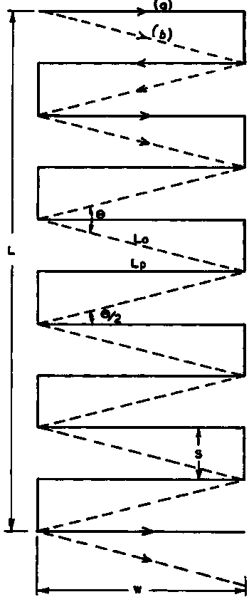
Np = Number of parallel Transects
No = Number of oblique Transects (Np = No)
Lp = Length of parallel Transects (nautical miles)
Lo = Length of oblique Transects (nautical miles)
w = width of survey area (w = Lp)
q /2 = oblique - grid half-angle (degrees)
L = Length of survey area (nautical miles)
d = duration of survey (days)
V = vessel speed (knots)
te = effective sailing time (hrs/day)
S = Transect spacing (nautical miles)(a) Parallel survey grid
(b) Zig-zag survey grid covering approximately the same area with same number of transects
Parallel grid
By a combination of simple algebraic and geometric considerations, one can derive the following formulae for the parallel grid.
V x te x d = Np x Lp + (Np - 1) x S = K
where:
V = vessel speed (knots)
te = actual sailing time at speed V (hours/day)
d = duration of survey (days)
Np = number of parallel transects
L = length of rectangular survey area (nautical miles)
S = equidistant transect spacing (nautical miles)
Lp = length of the parallel transect (nautical miles), (= W, area width)
Figure 68.
Assuming that: (Np - 1) @ Np we can write
Np x Lp +Np x S = K
and that Np S @ L then substituting Np @ L/S we obtain K = L (1 + Lp/S)
On examination, we observe that the quantity K is a constant for steady vessel speed, sailing time per day and duration of the survey.
Example:
V = 10 knots
te = 20 hours/day
d = 15 days
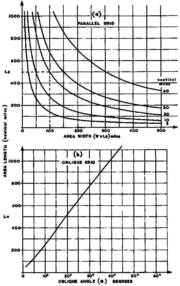
Then K = 10 x 20 x 15 = 3000 (total vessel track, nautical miles). Using the typical values above and solving the equation for L, we obtain
L = 3000 S/(S + Lp) nautical miles
The above equation is useful for planning purposes because, for a given total survey track and selection of equidistant transect spacing (S) as parameter, it gives the relationship between the rectangular area, length versus width, and hence the corresponding area coverage. Figure 68(a) presents a graphical solution of this equation for: S = 5, 10, 20, 30 and 60 nautical miles.
Oblique (zig-zag) Grid
To examine the different operational characteristics of the parallel versus the oblique transect pattern, it is convenient as a first step to distinguish between two situations as follows:
First situation: The assumption is made that both transect types span over an equal area-width and that the number of transects per unit area is the same. (In this connection it should be recognized that the distance S (Figure 67) does not refer to a transect but is commonly referred to as 'connecting leg' or 'inter-transect leg'). Based on these assumptions and a qualitative examination of the geometry of the situation, it will be realized that the operational differences are: (a) The oblique grid coverage requires shorter total survey track and hence vessel time, and (b) with increased obliqueness (measured by the angle 9), the ratio in total track length between the parallel track (Tp) and the oblique track (To) will increase. Mathematically this ratio can be established as follows:
Tp/To = (W + S)/Lo (76)
and as cos q /2 = (W/Lo), we may write
Tp/To = ((W + S)/W)Cos q /2
Example 1:
S = 20, W = 100
Then: Tan-1 q /2 = Tan-1 (20/100) = 11.31°
and: Tp/To = ((100 + 20)/100)Cos 11.31° = 1.177
Example 2:
S = 20, W = 20
Then: Tan-1 q /2 = Tan-1 (20/20) = 45°
and: Tp/To = ((20 + 20)/20)Cos 45° = 1.414
In practice it is rather unlikely that the angle q will assume values higher than 45° so, as a rough guide, one may consider about 40% as the maximum time saving offered by the zig-zag survey grid, given the above assumptions.
Second Situation: Here the assumption is made that an unknown size of survey area is covered by the same total track length, i.e. To = Tp; or alternatively, that both track types cover the same width, but not the same length (rectangular area).
In this case the angle q is dependent on the parallel transect spacing and could theoretically take any value from 0° - 180°. However, as in the previous situation it is not likely to exceed values of about 90°, i.e. q /2 = 45°. Based on the above, one can establish the following equations.
I. Total track length:
a. Tp = NpW + NpS = Np (W + S)
b.
and as we have specified that Tp = To, it follows that Np (W + S) = No (W/Cos q /2)
II. Area length consideration:
a. Lp = Np x S « Np = Lp/S
b. L0 = NoW tan q /2 « No = Lo/W tan q /2
Substituting Np and No in the previous equation related to track lengths, we obtain
Lp ((W/S) + 1) = Lo/Sin q /2
and finally:
Lo/Lp = ((W/S) + 1) Sin q /2
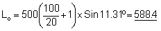
To illustrate the meaning of the above equation we first consider the graphs in Figure 68(a) and note that Lp = 500 for S = 20 and W = 100, corresponding to an angle tan-l (20/100) = 11.31°. Inserting the same values in the above equation we obtain
and Lo/Lp = 588.4/500 = 1.177
which shows that for the given angle, and when both survey grids have equal total track length, and span the same area width, the zig-zag transect pattern will cover an area approximately 18% larger. Using the same values for Lp, S and W, but a variable angle q /2 (i.e To = 3000 x Sin q /2), illustrates more clearly the relationship between the angular width of an oblique track and the resulting length or area coverage. The results covering an angular range from q = 1° to q = 45° are shown in Figure 68(b).
The task of selecting, or developing an appropriate grid design for an acoustic survey, requires that a number of criteria be satisfied both in regard to distribution information and sampling theory. At the outset it is useful not only to be cognizant of the survey objectives and operational aspects, but also to consider other important factors. A reliable independent acoustic estimate of stock size over a large area can be achieved with echo-sounder/integrator methodology provided that the following general conditions are satisfied.
(a) The fish stock is known to be available for acoustic measurement in the survey area.(b) The stock is relatively homogeneous over the survey area.
(c) The stock is not inextricably mixed with other stocks or fish populations in the area.
(d) Fish are neither too deep, nor too shallow to be effectively detected.
(e) Distribution of the fish over the area is sufficiently constant for valid extrapolations to be made from density measurements along widely-spaced survey transects.
(f) The fish are not disturbed by the vessel (avoidance effect) before measurement by the acoustic system.
For many stocks, these conditions are reasonably well satisfied; for others they are not. Clearly one must distinguish between demersal fish stocks and pelagic stocks; between pelagic stocks found in the northern hemisphere and those existing in tropical waters; between relatively stationary, pelagic stocks found in localized areas and those which are highly mobile and found in offshore waters; between relatively small, dispersed stocks (low-productivity areas) and those that are large and characterized by a high degree of school activity and often 'patchiness' (high-productivity areas). Also, the designer of the survey must taken into due account the characteristics of the survey environment itself.
The design of an acoustic survey aimed at providing absolute estimation of the size of a fish stock must be based on a thorough knowledge of the biology, distribution and behaviour of the fish. If such information is not at hand, a series of pilot surveys covering extensive areas and different seasons may be necessary before an efficient quantitative survey can be reasonably well designed.
Assuming that the required background information is available, the survey design process can begin to focus on the type of course track to be established. As defined by Shotton (1979) "The cruise track designs must be such that the estimate is unbiased and it should permit an evaluation of both the precision of different designs, or modifications of the same design as well as an objective evaluation of the precision of the sampling result".
It is at this stage that the theory and concepts of statistical sampling need to be drawn upon to aid in the design problem. For the present purpose it is convenient to discuss the principles and requirements for a statistical design, a process involving concepts such as: population (the fish stock), the sample (integrator survey values) and randomization (ie the selection of the sample, referring to the mode, or pattern, by which the allocation of samples was made during the survey).
Randomization is the cornerstone underlying the use of statistical methods in survey design and, ideally, it is used to prevent systematic sampling errors. By randomization we mean that the distribution of the fish comprising the population and the order in which the separate transects, or sample observations, of the survey are to be performed are both random. Some statistical methods require that the observations be independently distributed random variables. By properly randomizing the survey, we will assist in 'averaging out' the effects of extraneous factors that may be present. Having stressed the importance of randomisation, it should be pointed out that in terms of probability, the random sampling procedure means that, if the population contains N elements, each has a specified and usually equal probability of being sampled.
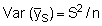
In section 9.1.0 we define and explain the systematic and random errors and draw attention to the fact that random errors will govern the precision of a stock estimate. We also indicate that a statistical parameter 'standard error' could be used to provide an estimate of the level of precision. Again, referring to Shotton (1979), "a survey track should be designed so as to permit objective evaluation of the precision of the sampling result". Some elaboration of this statement is desirable. First, it is important to be aware that when data from an integrator survey are treated as statistical sample units, each observed integrator reading (y) is conceived as an individual sample mean with its own underlying statistic (e.g.  ) and the entire set of data as a sampling distribution of means. In such a case the sample mean is
(77)
where n is the number of integrator readings in the sample, the variance is then given by:
and the standard error of the mean S.E. 
where S is the standard deviation computed from
(78)
The precise definition and the method of calculation of this is described in textbooks on statistical methods, for example in that of Goulden (1952). However, a good idea of its meaning can be grasped by considering that in about one case out of three the estimate will be in error by more than ± the standard error, and in one case out of twenty the estimate will be in error by more than ± twice the standard error.
Accepting these statements for our present purpose, it should be made clear
that the standard error can theoretically be subjected to a problem regarding
accuracy. When an estimate is suspected to have bias for which a correction
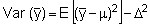
cannot be made, then the mean square error (MSE) should be used to measure the
error rather than the variance. The MSE includes components due to variation
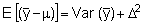
of the sample estimate about its expected value E ( )
and the difference between the expected value of the sample estimate and the
parametric mean, i.e. bias. The important property of the mean square error
can generally be shown as follows:
)
and the difference between the expected value of the sample estimate and the
parametric mean, i.e. bias. The important property of the mean square error
can generally be shown as follows:
Let one population parameter such as the mean m
be estimated by the sample mean  .
If this is a biased estimator so that
.
If this is a biased estimator so that
 where D
is the bias, either a positive or a negative quantity then by definition
where D
is the bias, either a positive or a negative quantity then by definition
Since 
or in other words:
demonstrating that the variance of the estimated sample mean  is an underestimate of the true variance around the population mean m. The value of the standard error, and hence the precision of any particular survey, will depend on
(a) the intrinsic variability of the fish population under study
(b) the number of sample units, e.g. integrator observations or the number of survey transects
(c) the design of the survey (and on the method of analysis if this is not fully efficient).
Considering the above factors, it will be realized that while we cannot control (a), we can increase the precision of the survey estimate by increasing the survey effort and where conditions allow, by adopting probabilistic survey design that would also be aimed at reducing bias in the sampling. After having briefly discussed the theoretical principles of a statistical survey design we may ask how well these procedures work out in practice. In fact, few designs currently used in acoustic fish stock abundance surveys satisfy the criteria of elementary sampling theory.
The main reason for this, apart from the fact that statistical sampling theories were not originally developed for the purpose of describing and quantifying aquatic fish populations, is probably that whilst truly statistical designs seem more feasible for demersal surveys, most applications of acoustic methods to date have concerned pelagic surveys, i.e. fish populations whose distribution pattern is often highly dynamic with respect to time and space and for which it is more difficult to define naturally occurring sampling units, or strata. In the latter type of survey there is a tendency to assume that a systematic survey grid pattern with non-randomly selected starting point, e.g. of the type shown in Figure 69 would serve as a valid approach because the fish themselves, by their general mobility about the fixed survey tracks, would take care of the theoretical 'randomization' requirement. Although the validity of such an assumption cannot be realistically made, this is ho reason why a systematic survey should not start in a pre-determined geographic position. For further study of this particular problem the interested reader is advised to consult well known textbooks on statistical sampling, e.g. Cochran (1963) and also papers of Shotton (1981), Bazigos (1981) and Shotton and Bazigos (1982).
After having reviewed the principal requirements for achieving successful and statistically efficient survey grid designs, we will now briefly examine some distinct survey designs and discuss their differences both in relation to their strategic and statistical characteristics. These are selected from published work on actual surveys and cover the following principal cases: (i) Large pelagic stock in an open sea area, (ii) Large pelagic stock exhibiting almost littoral distribution pattern, (iii) Medium-size, highly migratory pelagic stock, (iv) Small and relatively stationary stock, and (v) Demersal fish stock.
i) Large Pelagic Stock in an open sea area
A good example is presented in Midttun and Nakken (1977) and relates to the Barent Sea capelin stock. Figure 69, (a) and (b) shows a typical survey grid design based on parallel course lines with approximately equidistant spacing of 40 nautical miles. The present design does not allow for 'randomness' or proportional allocation of survey effort and, therefore, falls in the category of purposive surveys (Shotton, 1981). Emphasis is placed on maximum coverage, i.e. the vast geographic extent of stock distribution pattern (~ 120,000 mile2) can be covered adequately within the time available and other operational constraints.
This is particularly important for a stock-oriented survey which aims at estimating the total stock biomass and year-class strengths, as opposed to given area or region-oriented surveys. Prior to the survey, the most probable area of stock distribution is predicted in the light of information from past surveys, and fishing activities. The transects are generally run across the entire width of the distribution using either a pre-specified low, or zero, integrator value as the criterion for determining their north-south limits. For a large-scale survey of the type described, it is of crucial importance that the fish distribution over the area is sufficiently even for valid extrapolations and interpolations to be made from density measurements along the relatively widely-spaced survey transects.
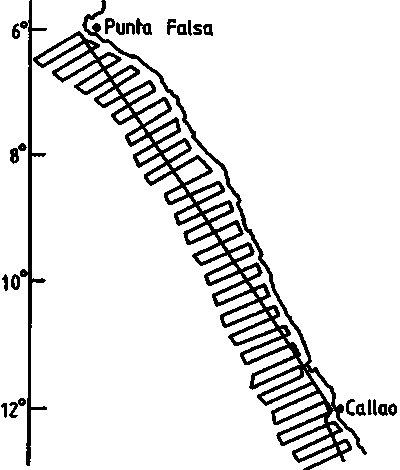
ii) Large Pelagic Stock Exhibiting Littoral Distribution
The Peruvian anchovy is a good example of the above situation, as detailed in Johannesson and Vilchez (1979). Figure 70 illustrates the type of survey grid pattern that was used as a standard over a period of many years when the stock level was 5-10 million tonnes. The parallel transect design was preferred, rather than the zig-zag design, largely because of ease in navigation and also because the selected course lines happened to minimize vessel movements (roll and pitching) against the prevailing wind directions. As in the previous example (1), no attempt is made to apply any form of random design but much emphasis is placed on dense coverage with transect interspacing kept to only 10 miles. Because the anchovy stock generally exhibit contagious distributions (as illustrated by the fact that for certain surveys less than 2 percent of the surface area could contain about 20 percent of the total estimated biomass), a relatively dense survey grid is required to obtain a representative sample, especially within the high-concentration areas. The size of the individual transects is determined by the inshore limit (often 15 m depth), depending on navigational safety, and the seaward limit, which can vary considerably from survey-to-survey. Consequently, the general strategy is to observe closely the level of integrator readings along the seaward transect run (these could vary in the range from 5-5000 mm), and after traversing the main concentrations with the readings getting lower and finally reaching zero-levels, the transect is discontinued and the vessel proceeds to work the next transect. Simultaneous evaluations of the corresponding echograms can also play a role in such semi-subjective decision making.
Figure 70.
iii) Medium-size, Highly Migratory Pelagic Stock
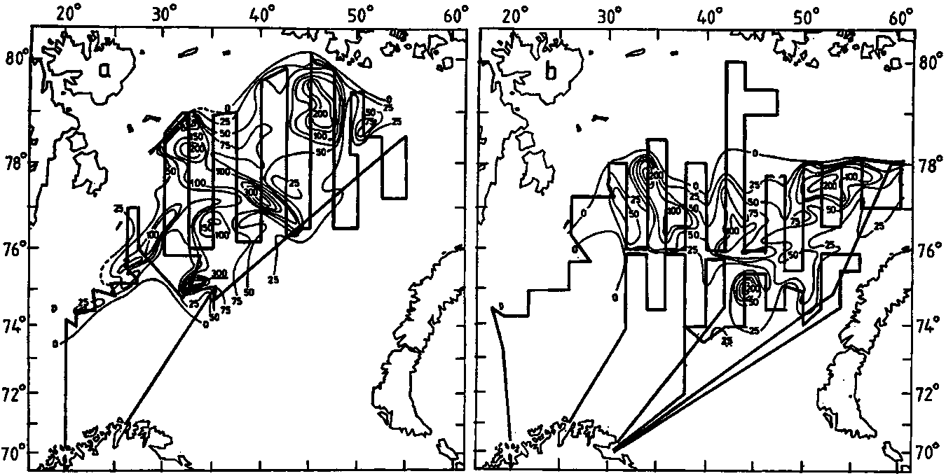
The Icelandic capelin stock provides an almost ideal example on the problems and possibilities of making quantitative acoustic surveys of highly mobile stocks. This particular stock has been subjected to intensive acoustic surveys since 1978, Vilhjalmsson, et al. (1982). The report is enlightening because it shows that the task of estimating the abundance of a pelagic stock for management purposes can present more problems of strategy and effort than of measurement. Figures 71a-d show the principal migration route of the capelin stock, together with several stock distribution patterns obtained from strategically timed surveys in the period from July 1979 to January 1982. Survey track-lines are not shown, but were of the common, non-random zig-zag type with varying density. Transect lengths were generally determined on the basis of 'zero' readings as explained under case (i). The strategy can be summarized as follows: During the feeding period which lasts from April to September-October, when the stock may break up into geographically separate components Figure 71b, a series of surveys is conducted to monitor the general distribution pattern and fish behaviour as well as the presence of drift ice, a factor that may influence the environmental conditions considerably. In the post-feeding period the stock gradually aggregates to form one unit again, (Figure 71), a process continually monitored by rapid surveys based on coarse track designs. Once the stock has formed a well defined geographic and depthwise distribution pattern (Figure 7 Id), coupled with good weather conditions, a replicate survey is conducted to obtain a reliable estimate of spawning stock size.
Figure 71. (a)
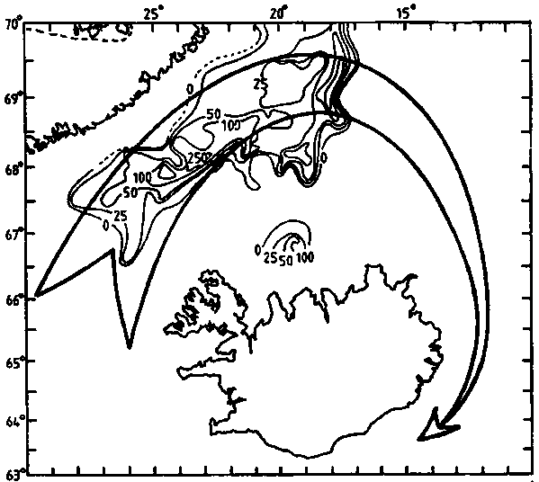
Figure 71. (b)
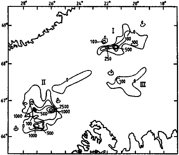
Figure 71. (c)
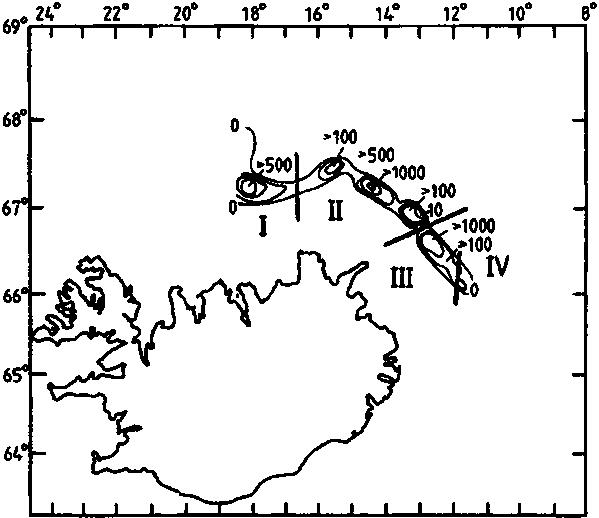
Figure 71. (d)
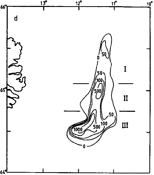
This example brings out an important factor when compared with the Peruvian situation because the latter is characterized by statistical implications, but the success of the Icelandic capelin surveys depends primarily on strategic execution.
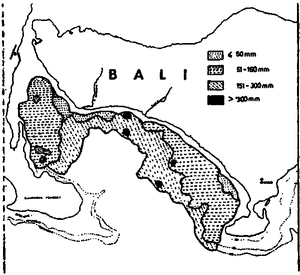
iv) Small and Relatively Stationary Pelagic Stock
Many examples could be cited but only the local sardine stock inhabiting the Ball Strait, Indonesia, will be mentioned. Figure 72(a) shows a typical survey design and (b) distribution pattern of the stock which, according to recent estimates, has a size of 30-40,000 tonnes. Again, the transect design is of the non-random parallel type, covering the whole area of interest. As will be noted, the inter-transect spacing is only 2 miles which is considered intuitively to be adequate for statistical purposes. The Bali Strait sardine can be considered a "stationary" stock for survey purposes so for this reason, the survey design above is maintained as a standard. Consequently, any demand to increase the precision of the survey estimates is not met by changing their statistical design. It is done by conducting replicate surveys, which, on the scale considered, are not too time consuming, or costly, and will give more realistic assessment of the absolute precision of the survey estimates.
Figure 72. (a) Survey grid for area near Bali
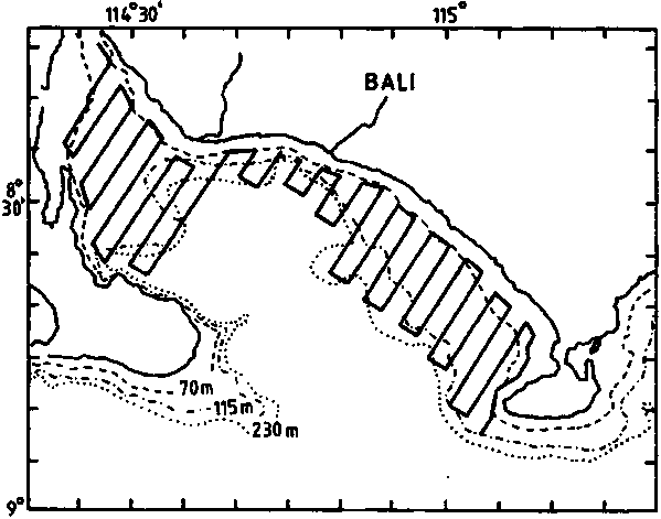
Figure 72. (b) Stratification of survey area into 4 density categories
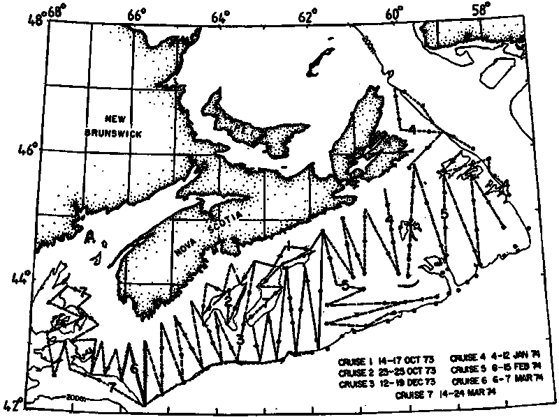
v) Demersal Fish Stock
An interesting design for demersal surveys is presented in Shotton (1981), who discusses the evolution of survey methodology at the Bedford Institute of Oceanography, Canada. Figure 73 indicates track design for an echo survey of demersal fish on the Scotian Shelf. The cruise tracks are designed to give representative coverage of the strata comprising the shelf. Thus, there is no explicit randomization of the design or proportional allocation.
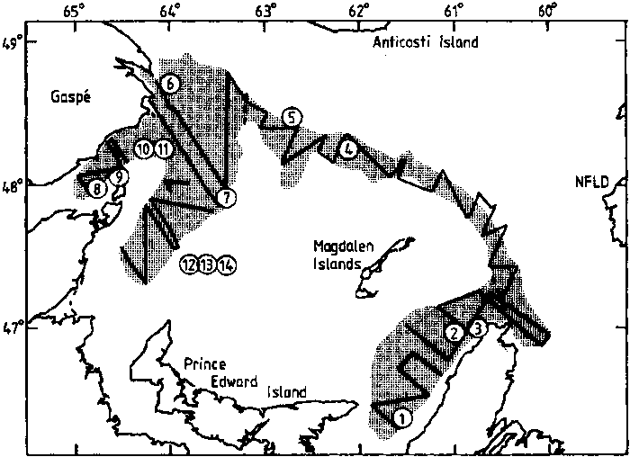
Figure 74 shows a design for an assessment of the 4T cod stock in the southern Gulf of St. Lawrence, intended to cover the expected summer range of the stock. The region is divided into blocks with one sampling transect per block located at random. Shotton (1981) writes: "If each transect is assumed to consist of a single sample, an estimate of the sample variance may be obtained by grouping the strata in pairs. Slight deviations in stratum size do not vitiate the method and the number of strata should be at least 20 to allow a minimum of 10 degrees of freedom in the estimated variance (Cochran, 1963)".
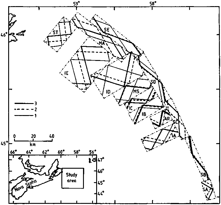
Figure 75 shows a design for the same stock, but over the winter period. The anticipated area of occurrence is stratified, and a replicate random design constructed with proportional sampling. Three transects per stratum were planned with additional transects to be allocated to more variable strata either during or after the end of the first coverage.
The examples given above illustrate some possible strategies and design of surveys for 5 different stock/environment situations. They are only intended to give a general idea and overview of the subject and have been selected particularly to emphasise the need for a non-abstract approach to the acoustic survey design. Experience so far has amply demonstrated that the biological and behavioural features of the individual target stocks can vary greatly as does their survey environment and hence the design criteria.
When a scientific echo-sounder is operated in conjunction with an analog integrator and manual data logging is performed, all operating controls should be kept in the optimum or standard positions to the maximum extent possible. This is important for maintaining uniformity of data collection, minimising equipment operational errors (see section 9.2) and to facilitate comparison of data between two or more survey vessels. Equipment manufacturers usually give detailed information about the functions of operational controls but they do not recommend standard control settings as these can only be established through calibration and extensive field experience with the equipment. A few general guidelines are offered below for standardization purposes with special reference to the Simrad EK sounders.
Frequency:
Selection of frequency is a simple matter of control setting in dual-frequency echo-sounders. Otherwise one integrator can be switched between two echo-sounders of different frequencies, eg. 38 and 120 kHz. The choice between frequencies depends mainly on the depth distribution of the fish and to what extent they may be mixed with planktonic organisms. If a depth range of about 100 m is sufficient and plankton is relatively abundant the 120 kHz echo-sounder should be selected because of its superiority in filtering fish echoes from the undesired plankton returns. Section 9.8.7 explains how small organisms tend to resonate at the lower frequencies. When a range of several hundred metres is required 38 kHz is necessary.
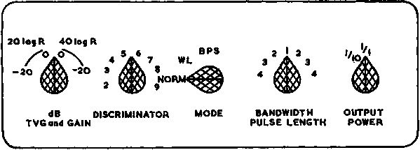
Transmitter Power:
Figure 76 below shows the front of an EK Transceiver together with the relevant operating controls. The transmitter control has a position for 1/10 and 1/1, ie. maximum power. In practical integrator surveys the 1/1 position should be adopted as a standard to ensure efficient echo detection by maximum signal-to-noise ratio unless consistently dense schools cause blocking of the receiver.
Figure 76. EK Transceiver Controls
Receiver Gain:
The maximum gain (0 dB) position should be used as a standard under all normal conditions. In extreme cases however, when an echo-sounder with particularly high performance (SL + VRT) is used on a fish stock with extremely high schooling densities (3 - 4 kg/m3), it will be necessary to reduce the gain to the -20 dB position.
Time Varied Gain (TVG):
The standard is (20 log R + 2a R) for integrator measurements of fish density. Only when making single fish TS measurements should (40 log R + 2a R) be used.
Pulse Duration:
A short pulse duration of 0.6 ms is recommended because long pulses contribute to an increase in integrator output variance and reduction in target resolution. However a short pulse duration reduces the signal-to-noise ratio (Ehrenberg, 1971) and (Bodholt, 1977). Where a 120 kHz echo-sounder is used and there is a mixed fish-plankton layer, a reduction to 0.3 ms may be preferable on the basis of careful experimentation.
Recorder Gain:
Whilst excessive gain may result in echo recordings which are confusing and difficult to interpret, the other extreme with low gain will not permit detection of the smaller fish species. Depending on the biological characteristics of the fish stock(s) and the overall performance of the equipment, a suitable standard gain may vary from 5-7 position, the exact gain level to be determined through field test.
Discriminator Control:
This control is complicated in operation and cannot be standardized. In principle it should be in a high enough position to ensure a stable bottom pulse (seabed echo, white-line), but sufficiently low to avoid such pulses being initiated by the dense fish concentrations. These competing requirements are often impossible to fulfil, but the strategy for the operation of this control is detailed in sections 9.2.2 and 9.2.4.
Receiver Bandwidth:
The recommended standard is 'Wide' for all echo-integration work. A 'Narrow' bandwidth may result in a significant portion of the received pulse energy being blocked in the receiver bandpass filter, and thus introduce bias in the observed integrator values.
Transducer Beamwidth:
The 38 kHz EK-sounders are commonly served by dual beamwidth transducers. Selection of a 'narrow' beam is done by the Transducer Selector (Figure 76) in position 1, with position 2 corresponding to a 'wide' beamwidth. It is not possible to specify a standard setting for this control but the criterion is to use wide beamwidth when surveying shallow-water areas (< 50 m) and narrow beam for echo-integration in deeper waters. Increased beamwidth and hence pulse volume reduces variance in the integrator output.
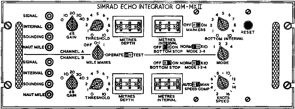
With reference to Figure 77 only the most strategic operator controls will be discussed below in terms of standardization.
Figure 77. QM - Integrator Controls
Gain Control (1A and 1B):
Two factors determine the selection of integrator gain
(a) the overall performance (SL + VR) of the corresponding echo-sounder
(b) the dynamic echo levels returned by the target fish stock.
The latter factor sets the limit as to whether two independent channels (A and B) can be used with the same gain setting or, if they must cover the whole depth layer of interest but need different gain settings to cope with the relevant dynamic range. Experience indicates that a gain of 10 dB or exceptionally 20 dB, is the most common setting. Clearly this must be modified to suit local conditions encountered at a particular time.
Scale Expander (x10):
Invariably this control is kept in a standard position (x10), ie. to expand integrator deflection by a factor of 10. The advantage of the scale expander is that it ensures adequate resolution in integrator readings at low densities without necessitating an increase in gain, which in turn invites saturation errors when the densities suddenly change.
Threshold:
This control should never be used if it can be avoided. The setting requires special caution, particularly during the integration of low densities and/or when relatively small fish makes up the target fish stock. A common practice to determine the optimum setting, is to display the envelope detected echo signal from the echo-integrator on an oscilloscope screen and carefully study the level at which the different echo components are rejected in response to a gradual increase in threshold settings on a scale 0-10. Subsequently the oscilloscope picture is compared with the corresponding echo recording (assuming that the 'Recording Gain' has already been adjusted so as to give the most representative recordings of the fish stock under study). The threshold control is then adjusted to a level whereby the faintest fish echoes just exceed the threshold setting. This is largely a subjective decision making process which has to be learned through experience and is really only applicable to relative abundance surveys. Common settings range from 0.5-3.0, also depending on the integrator gain setting as shown in the manufacturers specification. Replacement of the variable control by a switch system is strongly recommended.
Depth and Interval controls (2A and 2B):
These two controls are operated almost simultaneously to set the upper and lower depth limits of the layer to be integrated according to pre-established requirements. Changes in vertical distribution of the fish may cause the equipment operator to modify these settings during a survey. The minimum depth setting is determined by the start of the effective TVG range (usually 2-3 m depth below the transducer) and this may require adjustment, eg. to 10 m as a result of near surface noise created by turbulent water in adverse sea conditions. As for the lower limit it may be automatically changed by the intrusion of a bottom echo when a survey vessel is approaching shallower waters. If the bottom is very uneven (rugged), rocky or coral bottom, the bottom stop function may fail to work adequately (see section 9.2.2) and thus oblige the operator to switch to manual control of the lower limit at some safe distance from the seabed echo.
8.4.1 List of Equipment Factors
8.4.2 Data Recording and Storage
After the controls of the echo-sounder and echo-integrator have been set, or reset, it is essential to see that the correct factors are recorded for use in subsequent calculations. A list of these factors can be arranged so that it is easy to glance down and to select the figures to be used in the final calculations of MVBS  and fish density
  .
.
EQUIPMENT FACTORS
|
Echo-sounder frequency (kHz) |
|
|
Absorption coefficient: a (dB/km) |
|
|
Maximum TVG range: Ro (m) |
|
|
TVG gain: (20 log Ro + 2a Ro) (dB) |
A |
|
Performance of echo-sounder: (SL + VR) |
B |
|
(determined through calibration on standard sphere. |
|
|
Pulse duration: t ms |
|
|
Speed of acoustic waves c, m/s |
|
|
Pulse length (m) = ct x 10-3/2 |
|
|
10 log (ct /2) |
C |
|
Equivalent beam angle: y (steradian) |
|
|
10 log y (dB) |
D |
|
Mean width of integrated depth layer: |
|
|
10 log |
E |
|
Elementary Sampling Distance Unit: ESDU (n.mile) |
|
|
10 log (ESDU) (dB) |
F |
|
Fundamental QM gain factor by design: 1.54 |
1.54 |
|
10 log 1.54 |
G |
|
QM Scale Expander: SE (factor x1 or x 10) |
|
|
10 log SE |
H |
|
QM gain setting: QMgain (0, 10, 20 or 30 dB) |
I |
Identifying
X = (20 log Ro + 2a Ro) - (SL + VR) - 10 log (ct /2) - 10 log- 10 log (ESDU) - (10 log 1.54 + 10 log (SE) + QMgain) (79)
Then, the MVBS for one depth channel  is
is
(80)
and
(81)
finally
(82)
where M is the observed integrator deflection in mm, corresponding to conditions
specified by (X) and the mean target strength  .
.
Following the above-listed factors, the lumped logarithmic factor (X) can be readily calculated from the formula
X = A - (BCDEFGHI) dB
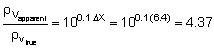
To conclude this section it should be pointed out that although the primary use of the Equipment Factors Sheet is to facilitate final calculations of mean volume back scattering strength (MVBS) and fish density, it is also a useful device to make quick checks on the effects of variability in any given quantity represented in eqn. (79). Thus, if for example the source level (SL) of the echo-sounder suddenly drops by 3.6 dB and the QM gain was increased by 10 dB without our knowledge, the resulting error would be
D X = D QMgain - D SL = 10 - 3.6 = +6.4 dB
which according to eqn. (82) would over estimate the density (r v) by a factor
In addition to the survey planning and operational strategies described in the fore-going chapters, it is necessary to select the elementary sampling distance unit (ESDU). This is the standard out-sailed distance unit to serve as the statistical sample of the survey. The size of the ESDU is closely related to the scaling of the survey. Thus, for a small-scale survey (relatively small area distribution of the target stock), an ESDU of one nautical mile may be chosen but for a large-scale survey covering an area of perhaps 50,000-100,000 nautical square miles, an ESDU of 5 nautical miles could be adopted as a statistically suitable sample. It should be noted that the sample size does not exclusively depend on the survey scale since its statistical efficiency is also closely related to the time-space characteristics of the fish stock distribution. A small ESDU is preferred when surveying relatively little known stocks and then, on the basis of the subsequent data analyses to determine the optimum ESDU for future surveys in the same area.
With the ESDU established and the survey under way, the incoming data are recorded at the end of each ESDU completed. If there are no automatic trigger pulses from the ships log the corresponding reset button on the echo-integrator and the marker of the echo-sounder are operated manually to define the ESDU intervals on the respective chart papers. In terms of time intervals such resets would, for example, be made every 6 minutes on a survey vessel cruising at a constant speed of 10 knots, given a one-mile ESDU. Following each reset, the two chart papers are properly annotated and the relevant data entered on an acoustic log-sheet. The format and the amount of information accomodated by acoustic log-sheets can vary considerably but the basic role is the same, ie. to provide a systematic and detailed record (or listing) of all relevant information yielded by the acoustic survey. The acoustic log-sheets represent the end-product of a survey cruise, containing data and other information categorized as follows:
1. Identification of cruise
2. Complete specification of the survey samples
3. Convenience data
4. Other data.
Category (1) generally specifies the type of survey, the cruise number, and on which vessel it is carried out, together with other characteristics of the survey exercise.
Category (2) forms the essence of the log-sheet.
It records the time of occurrence, provides an estimate of a three coordinate position (Latitude, Longitude and depth range), and one scalar property of each elementary sample, eg. the deflection in mm on the QM-integrator. Thus the log-sheets should contain one column for each item of the above information and one line (row) for a single entry in the log.
Category (3) includes data such as transect number and echo-paper roll number, etc. The latter is convenient, for example when a photograph of an echogram between two log-marks has been made during a survey and it is desired to compare it later with the original which can be found readily.
Category (4) may include columns for (a) 'Remarks' where visual observations are recorded, (b) sea surface temperature, (c) a footnote column and rows for continual verification and recording of standard control settings, and (d) station record for each time the ship is stopped to make scientific or other observations, with information on position, weather, gear used etc.
Data storage:
In its simplest form, this would be limited to a physical storage of the raw data material consisting of a stack of log-sheets and the corresponding echo-sounder and echo-integrator chart papers. Although this is apparently a trivial matter it must be remembered that when moist echo-paper is used, recording may fade rapidly and disappear (within hours or even less) in a hot and humid tropical climate. Thus to preserve and securely store the original records it may be necessary to install a special heating device for immediate drying of the paper before allowing it to enter a take-up spool. Subsequently, it Should be kept in a relatively dry and cool place away from exposure to light. Such arrangements make it possible to preserve the details of the original recordings during a period of many months or even longer.
A different storage of data is related to the use of a computer in conjunction with the QM-integrator. The analog output can then be converted into digital form for further processing and possible storage in various other forms (see Chapter 10 on Data Handling and Processing).
![]()
![]()
![]()

