![]()
![]()
![]()
IT IS NOW WELL KNOWN THAT AGRICULTURAL ACTIVITIES AFFECT AND ARE AFFECTED BY THE QUALITY OF THE ENVIRONMENT ... AND VICE VERSA.
Examples are plentiful: an increase in population prompts the movement of new settlement into regions with fragile ecosystems; land that is suitable for grazing livestock is encroached upon by people seeking to find new lands to cultivate; people are moving increasingly into what in the past were probably viewed as either pristine areas in need of protection to maintain biodiversity, or as areas marginal to agricultural production because of the fragility of their vegetative cover, soil structure, highly variable rainfall, or a mismatch between environmental conditions and land-use practices. Governments have encouraged (or at least not discouraged) many of these migrations into fragile areas.
There are scores upon scores of such examples, drawn from the past several decades and from all parts of the globe, and from areas at all levels of economic development, where agriculture-related activities have interacted in adverse ways with environmental processes, often leading to the degradation of both. It is important to note that there are also examples of successful interactions between agriculture and the environment.
Individuals acting on their own will continue, either out of preference or necessity, to seek new areas on which to grow food or graze livestock, as their demand for food and fibre increases.
Assuming that the best rainfed agricultural lands have already been put into production, indirect as well as direct anthropogenic pressures on different ecosystems will undoubtedly continue to increase (Glantz, 1994). The paradox here is that while people (and their governments) seek new lands to cultivate in order to increase food and fibre production, there is considerable evidence to support the view that proper care is not being taken of lands already proven to be agriculturally productive.
It is important to note that every ecosystem (forests, mangroves, inland waters and wetlands, grasslands, arid, marine, coastal, etc.) is at risk from exogenous influences, regardless of whether the causes of those influences are purely natural or anthropogenic, or are a combination of the two. As an example, tracking the findings of desertification studies over the past few decades underscores how difficult it can be to determine long-term consequences of the impacts of desertification processes (Tucker, Dregne and Newcomb, 1991).
Environmental changes can be abrupt or can be of the creeping kind: long term, low grade, slow onset and cumulative. Every change to the natural environment, however slight, could eventually prove to disrupt the sustainability of a specific ecosystem in the long term. Whether an uncontrolled (i.e. runaway) disruption eventually occurs will depend as much on decisions taken by individuals and governments as on natural factors. In many cases, changes to environmental conditions at the interface with human activities cannot be avoided. However, careful monitoring and timely analyses of the changes at this Ag-En interface can lead to appropriate management of those possibly adverse changes. As a result, many of these potentially adverse impacts can be minimized and mitigated, if not prevented.
This is not a new revelation. In a 1955 geography book, Dohrs and colleagues noted (p. 295) that
Because man must eat to survive, and because nearly all of man's food is either directly or indirectly a product of the soil, agriculture is one of the most important activities on the earth. ... Shortage of productive land is one of the major problems facing the world, and the development of world agriculture is that of too little land for the rapidly increasing population.
More than a decade later, Borgstrom (1972) coined the term "ghost acres". This notion was used in reference to the amount of land that would have been required to produce an amount of protein equal to that then being extracted from the marine environment. For example, the Japanese diet consisted of large amounts of seafood. Japan would have needed three or more times its then-existing agricultural land in order to compensate or replace the equivalent amount of protein it had been extracting from the sea. That amount of land was and still is not available. In other words, protein retrieved from the sea relieves considerable pressure on land-based resources to produce food.
Many different terms have been used to identify the way societies perceive the interactions between agricultural activities and environmental processes. Such terms include syndrome, dilemma, paradox and diagnosis. Each of these terms seeks to highlight some aspect of the serious attention merited by these interactions.
Researchers at the Potsdam Institute for Climate Impact Research (PIK) are concerned about climate change and human health issues. They refer to an environmental distress syndrome and its health effects. They note their concern about the depletion or disruption of the natural biophysical processes that are the basic sources of sustained good health (Petschel-Held et al., 1999).
Representatives of the International Crops Research Institute for the Semi-Arid Tropics (ICRISAT) have referred to the "productivity-environment" dilemma and the "agricultural intensification" dilemma, noting that "low productivity accelerates degradation and keeps people poor" (see www.icrisat.org). Others have referred to the environment vs jobs dilemma, the climate change and nuclear energy dilemma, the pesticide use vs productivity and jobs dilemma, and so forth (Schiermeier, 2001).
The Deep Ecology Movement has referred to the "living" paradox (Drengson and Inoue, 1995). From the Movement's perspective, governments must make a choice: should they leverage off death-giving technologies to save lives, or avoid technological misuse and live in ecological integrity? There also exists a public interest vs private gain paradox: people want a cleaner environment but do not want their lives to be disrupted and do not want to pay very much more to achieve it (Montgomery, 1996). In other words, do we take for granted that economic growth must adversely affect the environment? Yet another paradox related to the Ag-En interface is the challenge of "preserving access to the environment and its resources AND improving the standard of living" (Brower and Malcolm, 1991).
This term is related to the others, but in a different way. It is increasingly being used in an environmental context: the Earth is sick and we need to diagnose the sickness by its symptoms and root causes, and then to identify possible cures - an analogy taken from the medical profession. For example, UNEP undertook an Aral Sea Basin Diagnostic Study in the early 1990s in order to obtain a clearer picture of the causes and effects of a desiccating inland sea (UNEP, 1992). The UNEP study catalysed considerable interest and political action in the fate of the Aral Sea. There are calls for, and attempts to, identify appropriate indicators of objective environmental diagnosis. One corporation refers to the need for distance diagnostics through digital imaging. One can even apply for a Master of Science degree in Environmental Diagnosis at Imperial College in the UK (see: www.ic.ac.uk/default.asp?P=3608).
Thus, there are many ways to describe what goes on at the Ag-En interface. While attempting to stay focused on the notion of Ag-En hotspots, it is clear that any FAOwide hotspots activity could provide a framework for a wide range of activities, with the Ag-En activity being central. Other hotspots assessments could include, for example, food insecurity, fisheries, livestock, nutrition or disease. Hotspots identification, monitoring and analyses would help to identify numerous environmental policymaking dilemmas, paradoxes and syndromes of interest to FAO, as well as to identify locations where diagnostic environmental studies need to be undertaken and tools are needed.
In any hotspots monitoring arrangement, it is imperative to establish baseline conditions. As an example, one way to develop a hotspot baseline would be to use an approach taken to investigate the slow-onset, low-grade, incremental but cumulative degradation in the Aral Sea Basin in Central Asia (Glantz, 1999). In that assessment of several of the Basin's creeping environmental problems, a group of researchers from different disciplines and countries sought to identify thresholds over time of various environment-related changes (physical, biological and societal). The suggested thresholds of change that follow could provide a baseline and a timeline for tracking the development of Ag-En hotspots, many of which hotspots are already active:
Threshold 1: When was there an initial awareness of change?
Threshold 2: When was there a realization that the change had become a problem?
Threshold 3: When was concern expressed that the problem had become a crisis?
Threshold 4: When was there an awareness of the need for action?
Threshold 5: When was action taken?
It might be interesting to consider undertaking such a hotspots assessment for Lake Victoria in eastern Africa, using the creeping environmental problems approach, as various groups in FAO and elsewhere have already undertaken studies on various specific environmental changes in the Lake Victoria basin. The accompanying box provides an example.
The concept of "foreseeability" has been used for over a century as a legal test for liability. It is
"a concept used in various areas of the law to limit the liability of a party for the consequences of his/her acts to consequences that are within the scope of a foreseeable risk, i.e., risks whose consequences a person of ordinary prudence would reasonably expect might occur... In tort law... a party's actions may be deemed negligent only where the injurious consequences of those actions were 'foreseeable'" (Gifis, 1991).
There are several variations of the meaning of foreseeability. For example,
"the foreseeability element of proximate cause is established by proof that the actor or person of reasonable intelligence and prudence should reasonably have anticipated danger to others created by his or her negligent act" (Gifis, 1991).
Note that inaction is also considered to be a form of action. The negligence referred to is that of the authority who failed to have foreseen adverse impacts.
"Foreseeability encompasses not only that which the defendant foresaw, but that which the defendant ought to have foreseen" (Gifis, 1991).
The concept of foreseeability can be extremely useful for identifying the possible impacts of human activities related to agriculture on the environment in general, as well as on specific ecosystems of concern. "Foreseeability" differs from the concept of "forecast" or "predictability" because it neither depends on nor implies any quantitative description of probability of occurrence. It suggests, for example, that a reasonable person can conclude that certain agricultural practices in certain types of ecosystems, in the absence of any action to change them, will have knowable adverse impacts on environmental quality. Those adverse impacts can lead to such degrading processes as soil erosion, deforestation, fertilizer and pesticide overuse, excessive water diversions, poor irrigation practices, mechanization of land-clearing activities in marginal lands, and inappropriate landclearing and wood gathering for cooking and heating (including charcoal-making for income) and construction.
Today, researchers have collected scores of examples of what happens when agricultural activities expand into new areas. In some instances, the land is transformed from one use to another. In other instances, however, that land use leads to varying degrees of degradation. What appears at first to be a harmless and productive change in the use of the land can (and often does) lead to a greater level of degradation that is harmful to both the environment and to the people whose livelihoods are based on the sustained productivity of that environment. People and governments need to be alerted as soon as possible to environmental changes that are often incremental, but are cumulative and foreseeably damaging in the medium to long term. Taking agricultural practices into new areas, perhaps even into pristine ecosystems, launches one onto a proverbial "slippery slope" in the absence of precautionary policies and practices. The concept of foreseeability can help decision-makers evaluate long-term impacts of Ag-En decisions before those decisions are taken.
|
Box 1. Lake Victoria as a hotspot? Considerable attention has been focused on Lake Victoria in eastern Africa during the last few decades of the twentieth century. At first, scientific researchers focused their efforts on the variations in lake levels to determine global and continental climate history on millennial to century time scales. Today, research concerns centre on environmental degradation taking place in various ecosystems and in areas surrounding the lake. As an example, many changes have taken place since the Nile perch was introduced to the lake around 1960. What seemed to have been a good idea in terms of economic development for the region turned into a nightmare for local inhabitants dependent on basin resources. Briefly, the Nile perch was introduced to create a fishing industry producing fish for export. Factories and large boats were then introduced to increase capture and processing activities. The Nile perch lived off the smaller fish species in the lake. Soon the number of smaller fish was greatly reduced, with a notable negative impact on the livelihood of small-scale fishers and fishmongers. This led to worsening nutrition of local people around the lake. People bought the discarded Nile perch bones from the fish factories, because it was not easy for machines to remove the remaining ten percent of fish flesh from the carcass. Nile perch is an oily fish, unlike the local smaller fish, which could be sun-dried. The carcasses had to be boiled and, therefore, charcoal was needed for the fires. This led to an increase in the cutting down of trees and shrubs around the lake. All the time the population around the lake increased, putting more pressure on the lake as well as on the surrounding land. Raw sewage and factory-produced effluents from the riparian states (Kenya, Tanzania and Uganda) as well as from other basin states (Rwanda and Burundi) flowed into the lake via rivers and streams. This nutrient loading of the aquatic ecosystem led to a sharp and uncontrolled increase in water hyacinth, which in turn adversely affected lake navigation and blocked sunlight from reaching the water's surface layer. This reduced the amount of oxygen in the water column, further reducing biological productivity of the lake's ecosystem. Health conditions deteriorated markedly in the region for a variety of reasons, some of which are mentioned above. HIV too added to the deterioration of health conditions in the region of the lake. Many fishers and fishmongers became unemployed and had fewer resources with which to buy or barter food for their families. Poverty increased sharply in those once successful, even if only at a subsistence level. Today, there are several studies focused on Lake Victoria and its basin: physical and biological, scientific, socio-economic, health and safety, equity and humanitarian, anthropological, sustainable development, sectoral (fisheries, forestry, agronomy, livestock), and so forth. There are many organizations that could work together to identify hotspots, even flashpoints, as well as Areas of Concern in the lake's basin. This regional case study could serve as a prototype for other regional hotspots audits and for identifying the many hotspots partners that could be brought together to address lake-related hotspots and flashpoints Michael Glantz |
The notion of "present futures" is an important aspect of foreseeability. Identifying the rates and processes of land transformation in different ecosystems and identifying extreme hotspots (i.e. the hottest) that already exist can save considerable time, energy and resources, if that information is properly used to show responsible parties how a pursuit of their "business-as-usual" activities will ultimately affect the environment on which a country's citizens and economy depend. This could be viewed as "foreseeability analysis".
The use of recent analogous situations, i.e. "hindcasting", in a search for present futures can provide a reality check with regard to presenting realistic projections of societal and environmental changes within the region of the hotspots. They would be "case-based" and "placebased" scenarios; that is, scenarios that have already occurred somewhere else and in the relatively recent past.
Reviewing past responses of decision-making authorities to the forecast and impacts of an adverse climate- or weather-related event can help to identify where, when and why good decisions as well as bad ones had been taken.
"Hotspots" has become a popular term in recent years. It is increasingly being used to draw attention to particular situations of interest or concern.
"Hotspots" is, in fact, a strange notion. Its specific meaning depends on the context in which it is used. It brings to mind a location, activity or situation that is beyond the usual or out of the ordinary.
The term also has societal aspects: cultural hotspots, skiing hotspots, tourist hotspots, scuba hotspots, and so forth. Thus there are at least two general uses: one category uses hotspots in a positive sense, and the other in a negative way. For the general public, the term more than likely suggests a positive experience: hotspots for dancing, fishing, vacationing, and so forth. The negative sense suggests something unwanted or unfavourable that is likely to occur or is already in progress.
In the world of environmentalists, hotspots refer for the most part to negative changes. For FAO in particular, it refers to adverse aspects of the interface between agricultural activities and environmental processes, its primary concern. Some people might consider the recent surge in the use of the term "hotspots" to be a new environment-related fad. However it is viewed, the hotspots concept can be used to identify situations that, if left unattended, could prove harmful, both to the environment and to those dependent on it.
Recently, Conservation International (CI) published a map identifying biological and soil hotspots[1] (locations at risk to biodiversity loss). Interestingly, on the same map, the CI also introduced the notion of "bright spots," i.e. areas in which the degradation of soils had been either arrested or perhaps even reversed.
For our purposes, hotspots can be defined as locations or activities of interest to a group or organization where human interactions with the environment are considered to be adverse to the sustainability of an ecosystem or the human activities dependent upon it. It is a segment along a continuum of environmental change. This definition is purposely quite broad in order to allow for entry points into an FAO-wide hotspots programme for other activities related to agriculture, forest, fisheries, food security, and nutrition.
The first concrete action to be taken in setting up a hotspots activity is to decide on an operational definition of hotspots, and then to define it more specifically in the context of the adverse interactions between agricultural activities and environmental processes.
It will be necessary to distinguish hotspots from flashpoints, critical zones (or areas of concern (AOCs)), and areas where land is transformed as a result of agriculture-related activities.
It is important to keep in mind the fact that not every interaction between agriculture and the environment is a negative, zero-sum interaction, where either the environment or agriculture wins and the other loses. For example, mixing agriculture and forested areas could be beneficial for both agriculture and the environment.
Mixing livestock rearing and cultivation has also proven to be beneficial to both activities, as well as to the environmental setting in which they are taking place.
The overriding objective of a hotspots focus is to avoid creating them where they do not yet exist. A hotspot of environmental change (such as degradation) encompasses only a portion of a continuum of the full range of environmental changes.
While the hotspots portion of that continuum is the one that usually captures the attention of the media and policy-makers, in fact it is the portion of the process of change that precedes hotspots - the AOCs - that deserves more attention. Intervention in a potentially emerging hotspot can provide the most timely and least costly response to environmental problems.
A useful way to look at the notion of hotspots is to put it in a broader context. Schematically, it can be represented in the form of a pyramid.
The bottom five layers of this pyramid represent placebased conditions, that is, they are geographically defined areas. The upper two layers are time-based conditions, that is, they can occur anywhere and still have an influence on what happens to the place-based conditions. This graphically portrays one way to view the hierarchy of Ag-En interactions. It is important to note that there are human aspects to be considered at each level of the pyramid, such as why those interactions are taking place with adverse consequences.
The base of the pyramid represents the pristine environment. The next level focuses on land that is being or has been transformed, for example, from rangeland to irrigated or rainfed cultivation or transformed from a forested area to rangelands or cultivated areas, or from a mangrove forest into shrimp farms. Such changes are not necessarily degradation of the land's surface or of the vegetative cover, but are a change in land-use practices and a conversion in value from a societal perspective, depending on the spatial scale and the type of land conversion taking place.
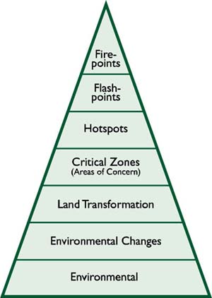
The next level in the pyramid represents zones critical to human activities (AOCs). These are fragile zones, such as the tropical rainforests, semi-arid and arid lands, and inland water bodies or coastal waters. They are known to be highly susceptible to degradation in the face of inappropriate landuse activities or a variable or changing climate regime, or both.
Areas that have been transformed for agricultural purposes often become AOC critical zones and potentially hotspots. Critical zones can encompass entire countries, regions within them, or specific ecosystems. It could be an area "invaded" by people in search of lands to cultivate or by refugees from war or from degraded environments. Refugees tend to use the known farming practices that they had relied on in the areas from whence they came, techniques that were probably relatively more suitable for those soil or climatic conditions. Arid lands provide a good example of AOCs. While they can be sustainably exploited under certain known (i.e. tried and tested) land-use practices, the arid land surface (its vegetative cover and soils) becomes easily degraded in the absence of those practices. The irrigation of dry lands can be successful and sustainable in the long term, and in many places it has been. However, in the absence of proper drainage facilities, salinization and waterlogging of the soils can appear. Salinized soils must be repeatedly flushed of salts before planting can begin. If not flushed with clean water, the land may eventually have to be abandoned. Mangrove forests in general also represent an AOC.
The next level of the pyramid refers to hotspots. As noted earlier, these are locations where changes in the way the land is used for agriculture-related activities impinge on the ecological health of the environment in which those activities are taking place (CENR, 2001). Hotspots are areas where the degradation of the land surface (reduced soil fertility, as manifested by declining crop yields) has begun to appear. The hotspot level of degradation can be sub-divided into hot, hotter and hottest.
The next level of the pyramid represents the type of change referred to as "flashpoints". Flashpoints represent catalysts within the hotspots regions. They are time-based, whereas hotspots are place-based. Flashpoints can contribute to the instability in governments, economies, cultures or ecosystems.
A severe drought, for example, can become a climaterelated flashpoint that generates or worsens political instability (e.g. the fall of the Selassie regime in Ethiopia in 1974, or the 1994 Rwandan crisis that coincided with unusually high food prices brought about by drought and an influx of refugees from Burundi).
Most often, meteorological drought by itself is not the only problem facing a country at a given time. Thus, the source of instability is a combination, often of drought with another adverse socio-economic or political change. For example, drought + high food prices can lead to famine; drought + political instability can lead to regime change; drought + poverty can lead to migration into marginal areas by the poor in search of farmland. This might be referred to as the "drought +" factor. Flashpoints convert severe land degradation problems into high-visibility political issues.
| [1] http://www.conservation.org/xp/CIWEB/strategies/hotspots/hotspots.xml. |
![]()
![]()
![]()