![]()
![]()
![]()
4.1 Site-Specific Forest-Use Planning
4.2 Planning Levels
4.3 Amendments to the Plans
4.4 Planning Staff
4.5 Plan Approval Process
4.6 Management Information Systems/Geographic Information Systems and the Planning Process
|
OBJECTIVES To develop comprehensive strategic and operational planning mechanisms that ensure that forest values will be protected during harvesting. To ensure responsible use of land and forest resources for the maximum benefit of all stakeholders. To develop plans that take account of the socio-economic and environmental impacts on the area. To provide for efficient and environmentally responsible means
of harvesting timber. |
Forest-use decisions should be documented in the logging contract and in the forest harvesting plan.
Forest planners should determine the availability of both cadastral and physical land classification information, which could include:
|
Physical land classification |
- Contours/Slope |
|
|
- Soil classes |
|
|
- Drainage patterns |
|
|
- Forest type and distribution etc. |
|
|
|
|
Cadastral land classification |
- Cadastral boundaries (landuse/ownership) |
|
|
- Conservation areas |
|
|
- Ownership boundaries etc. |
This planning information, combined with consultation with stakeholders, should be used to identify suitable areas for production and conservation. Where this is unavailable, a combination of field checking, aerial photo interpretation/satellite imagery and data interpretation will refine details for the planning process.
Planning for forest harvesting is a multi-tiered process often comprising three levels (Figure 4-1). These levels are:
1. Long-term planning
2. Operational planning
3. Task planning.
Figure 4-1: Planning System Structure
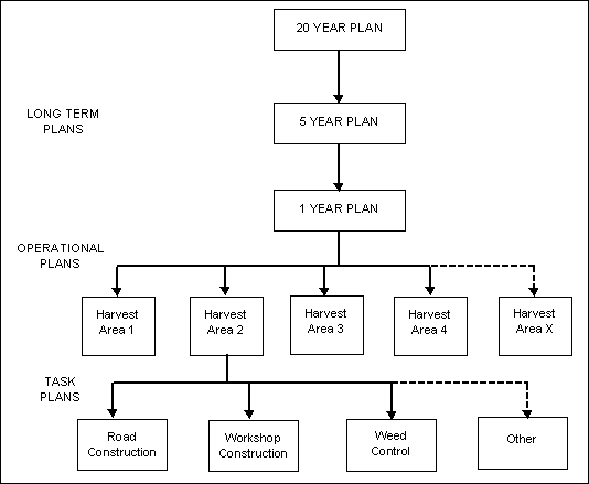
4.2.1 Long-Term Planning
Long-term or strategic plans are broadscale advanced plans that are based primarily on available information. They serve as a guide for future activities in all operations. Because of the timescale involved, they are subject to change. More than one plan can be used to allow planning across a range of time periods. The long-term plan should include, yet not be restricted to:
4.2.2 Operational Planningidentification of areas to be reserved for biodiversity conservation;
Operational plans are developed for each individual harvest area, based mainly on site inspections. Maps of the harvesting block (coupe), showing a detailed plan of the activities to occur, form the main elements of the operational plan (Figure 4-2). These are to be based on the guidelines described in the Operational Planning Section of this Code. Major points to be covered in the Operational Plan include identifying:
4.2.3 Task Planning
Task planning is undertaken by the harvesting company and describes responsibilities of staff and how work is to be carried out. It is appropriate that task plans be prepared after the operational plan has been developed.
Once the plans are developed by the concessionaire/contractor enterprise, the plans should be submitted to the relevant forest authority for approval.
The following table provides recommendations for each planning level.
Planning Procedure
|
|
Long-Term Planning |
Operational Planning |
Task Planning |
|
Needs |
1:100,000 - 1:25,000 scale base maps are often appropriate Aerial photographs Land ownership boundaries Contour information Watercourses Future development plans Prior land classification Inventory (often 1% intensity) |
1:10,000 scale maps are often appropriate. The operational plan is a more detailed version of a section of the Annual Plan. It deals with specific harvest areas just prior to logging. Inventory (Between 10 and 100% intensity) |
<1:5,000 scale maps often appropriate. Short-term plan for a particular job, e.g. road construction. Job marked in the field. Briefing of operators by their supervisor. May be input from local supervisory staff. |
|
Inspection requirements |
Low intensity, e.g. aerial inspection, ground inspection of
key points. |
Ground inspection to define operational details such as
excluded area boundaries, watercourses, roads, major skid tracks and log landing
locations. |
Intensive ground inspection. Operators must inspect the area before starting the
harvesting. |
|
Detail shown on the map |
Boundary of licence Key points (e.g. log ponds) Broad roading plan (e.g. concession wide) with major roads Areas previously harvested Current operations Future operations and order in which coupes will be logged NOTE: These details are subject to change at the operational
planning stage when more detailed ground inspections are made. |
Boundary of operation Excluded areas Designated watercourses and buffers Land ownership boundaries Key points (e.g. log ponds) Detailed roading plan for the harvest area; Major skid tracks and skid direction; Minor skid track pattern and direction; Log landings Watercourse crossings (permanent and temporary) Sites where operations do not adhere to the Code (for special
inspection by Forest Authority Officer) |
Plan shows the whole operation. Critical aspects are highlighted and discussed
thoroughly. |
|
Details of written plan submitted with the
map |
Compliance with current planning guidelines Proposed silvicultural system for harvesting Location and design details for Log Pond construction Design for any new camps |
Period for which the plan applies. Species mix. Anticipated volumes and net area. Details of, and reasons for, any deviations. |
Specifications for the job must be explained to operators. - construction standard |
|
When is the plan submitted? |
Long-term |
At least 3 months before operations in a particular
area. |
Immediately before the job commences. |
|
Who sees the plans? (stakeholders) |
Landowners/representatives Forest Department (head office and local supervisory staff) Provincial Government Camp Manager Production Manager Surveyors |
Landowners/representatives Camp Manager Production Manager Surveyors The Forest Officer immediately responsible for the operation
will inspect the Operational Plan in the field with the Company
representative. |
Operators for specific tasks, e.g. road construction, felling,
skidding. |
|
Who approves the Plan? |
Forest Authority |
The responsible Local Forest Authority Officer may approve Operational Plans provided that they are in line with the intent of the approved Long Term Plan. Decision is given following field inspection. Major departures from the intent of the Long-Term Plan require
the approval of the Forest Authority. |
The Forest Planning Team of the Concession Company. Decision given following field inspection. |
Should any major changes to the fundamental approach be required (in either the long-term or operational plans), details of the proposed changes should be resubmitted to the Forest Authority.
Stakeholders are to be advised of approved departures from the plan once approved.
The following table provides recommendations for effective forest planning.
|
Minimum requirements |
It is suggested that a minimum planning team consist of a
professional Forest Planner and two (2) assistants, employed by the concession
holder for each harvest area of approx. 500 ha. |
|
Skills |
Experienced in:
|
|
Duties and responsibilities |
Required to:
|
The following steps are suggested for the planning approval process:
Figure 4-2: Example of Operational Planning Map
Many countries in Asia and the Pacific are now developing the capability to use a Geographic Information System (GIS) and computer-aided mapping for small- and large-scale harvesting operations. Acquiring and developing this information and technology can be undertaken in a number of ways. The recent trend in forest practice is to develop complete Management Information Systems (MIS) which provide the framework for all levels of planning. GIS is the basic tool for such an approach.
4.6.1 Mapping Systems
Generally a GIS is developed to hold both physical (e.g., contours, drainage patterns) and political (e.g., ownership boundaries, concession boundaries) land classification information. A GIS is best described as a series of referenced map layers that record spatial data such as contours and harvest boundaries. Associated with the spatial data are point attributes that include species, age and management history.
Information can be collected from:
The GIS can then be used to retrieve data required for planning. This data can then be used to generate forest management and harvesting maps.
4.6.2 Forest Management Maps
Forest management maps show the relevant information required for a particular planning decision. They should be developed at the appropriate scale, which are often country-specific and for a given purpose.
4.6.3 Inventory
An inventory should be undertaken to assess the forest and determine the volume and type of wood available for harvest. This information allows planners to match required wood types and volumes with cutting areas. Inventory information can also be linked with GIS systems. To assist in the planning process, inventories should be designed to enable standard errors to be determined along with sampling intensities. However, many countries adopt a specific sampling intensity for the inventory, irrespective of forest variability.
4.6.4 Training
The competency of staff in the use of equipment and techniques required for inventorying forests, using GIS and MIS, etc. should be ensured through appropriate training programs.
![]()
![]()
![]()