![]()
![]()
Introduction to flood management
It is becoming increasingly apparent how important flood management is in our Mekong Basin. This appears particularly true for the Lao PDR, given its strong economic dependence on agriculture. In a least developed and landlocked country, its reliance on natural resources, particularly water and related resources, is uncomfortably high. Given the terrain of this country, it is very much at risk. Approximately 80% of the population live in rural areas, including many poverty-stricken people, mainly in the Mekong River valley or plains. These factors indicate that Lao people are particularly vulnerable to flooding which threatens crops, particularly our staple food, rice.
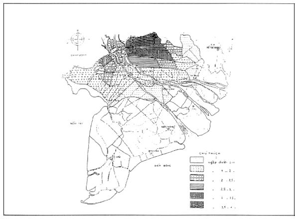
A recent example shows how flooding can take its toll on this country, leaving people powerless, and often hungry as rice paddies become inundated. In 1995 during the flooding season, 102 912 hectares of the Vientiane Plain was under 0.5 – 0.8 metres of water for up to 8 weeks. In human terms, the 1995 flood affected 153 398 people in the Vientiane Plain (out of a total population of 653 013 persons), 26 603 households, or 427 villages. This is just one example of the many areas affected by flooding every year. Flooding occurred in the Vientiane Plain, the Bolikhamsay Plain, Champassak Plain, SebangFai Plain, and the Sebanghiang Plain (see Map 1).
The importance of this situation to the Lao PDR cannot be denied. It is vulnerable to the devastation of flooding, and lacks the resources (financial, technological and human) to adequately defend itself. Obviously, agricultural and rural development is a high priority for the government of the Lao PDR, and it is the policy of the Lao Government that the Lao National Mekong Agreement strives to uphold, in accordance with the Socio-economic Development Plan. Furthermore, national interests must be balanced with more regional interests, or specifically for the Lao National Mekong Committee (LNMC), with the Lower Mekong countries: Thailand, Cambodia and Vietnam, by upholding the 1995 Agreement on the Cooperation for the Sustainable Development of the Mekong River Basin.
Under the Agreement, issues such as flooding are clearly important as they relate to the natural environment, flow maintenance, economic well being and living standards. Moreover, they are of a transboundary nature. Furthermore, activities dealing with such issues should be carried out in “the unique spirit of cooperation and mutual assistance.” After all, flooding is something that affects us all, and cooperation can therefore benefit us all, by sharing resources, skills, technologies, experience and expertise. Furthermore, we also need to be aware that we are responsible for our activities that could have effects in downstream countries.
Bouriboun Sanasisane, Acting Director, National Mekong River Committee
Vientiane, Lao People's Democratic Republic
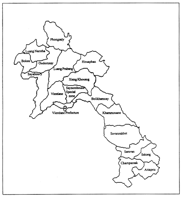
MAP 1
Lao Peoples' Democratic Republic
Given our dependence on the Mekong and related resources, it is no wonder that Laos has been involved in the Mekong River Commission (MRC) and its two predecessor organizations since its inception in 1957 with the establishment of the LNMC. While there was some unclarity regarding its role for some time, the LNMC is now located within the State Planning Committee. The LNMC comprises vice-ministers and representatives from diverse, yet relevant and related line ministries, such as:
FIGURE 1
Data flows from Lao PDR line ministries to the MRC
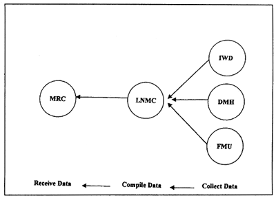
This grouping represents the crosssectoral interests involved in Mekong development. It is, therefore, the role of the LNMC to act as the coordinating mechanism between the MRC, currently based in Bangkok, and the relevant line ministries of the Lao Government. In all our activities, national interests must be balanced with regional interests, which ultimately serve us all. So, to take flooding as the case in point, Lao government policies will be fed into MRC projects related to flood management, irrigation, hydrology, environment, monitoring, mapping and so on.
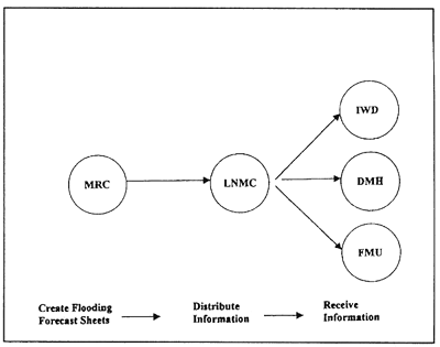
FIGURE 2
Information flows from the MRC to the Lao PDR line
ministries
With regard to flood issues in Laos, the main departments the LNMC coordinates with are:
FIGURE 3
Financial flows from the MRC to the Lao PDR line
ministries
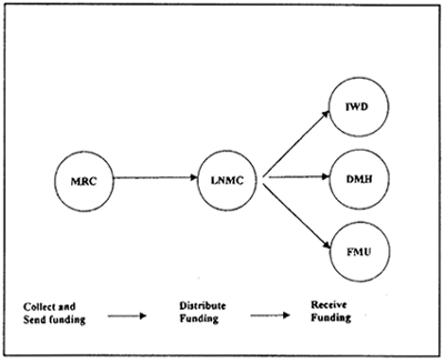
The main transfers that take place are:
Once information from the various ministries has been collected from the four National Mekong Committees, the MRC compiles this raw data to produce Flood Forecasting Sheets using the Streamflow Synthesis and Reservoir Regulation Model. This information is then distributed to the riparian countries through the National Mekong Committees for national action.
At present this is an appropriate role for the LNMC to play. Currently there is no decisionmaking power in the area, so there is no overlap or duplication with other departments with more expertise. The LNMC was set up as and continues to be a coordinator between national and regional interests and activities. All information regarding flooding can be gathered from different departments or agencies, and collated to present a national strategy to the MRC, which will be incorporated into a regional strategy. Similarly, information regarding regional issues can be communicated to the relevant line agencies, so department staff can learn from the experience of others, and ensure that policies reflect the interests and well being of the region.
TABLE 1
Flooding in the Vientiane Plain, 1995.
Persons affected: 153 398. Households affected: 26 603 Villages affected: 427
| Land use | Damage | Percentage |
|---|---|---|
| Transplanted area | 42,337 ha | 41.14% |
| Stream, swamp, bamboo, grassland | 10,140 ha | 9.85% |
| Clear forest, hill and pasture area | 31,354 ha | 30.47% |
| Residential and other areas | 19,081 ha | 18.54% |
| Total flood area | 102,912 ha | 100% |
| Rice crop | Other crops | |
|---|---|---|
| Total area | 61,142 ha | 17,167 ha |
| Flood affected | 34,471 ha | 7,866 ha |
| Damaged | 30,962 ha | 4,313 ha |
The LMNC can strengthen sectoral links, particularly with regard to flooding. With expertise in hydrology it is working on the hydrological network in cooperation with the relevant ministries on improving the hydrometeorological stations in Lao PDR for higher levels of accuracy, efficiency and effectiveness. This is a basinwide project which will contribute to improving flood management in Laos and the Lower Mekong Sub-region. Links with improving inundation mapping and GIS usage are also clear. So these links are far-reaching, with a broad spectrum of benefits.
It is important that the LNMC is recognized as a key development player regarding Mekong activities. Donors and international organizations must consult the LNMC regarding particular activities for an overview of how an issue is being addressed in different sectors and where the national priorities lie. This is essential to avoid the increasing problem of overlap and duplication and overlap of activities and responsibilities. Development activities must be coordinated. Similarly, government ministries must acknowledge the LNMC has a valuable role to play in not only coordinating between ministries, but in ensuring national policies are in line with regional priorities. This is particularly important with respect to flooding, as there is much to be saved and gained through cooperation.
In the future, however, the National Mekong Committees (NMCs) could consider broadening our responsibilities. For instance, involvement could be increased with exchange of information with other countries, such as the People's Republic of China and Myanmar. Both countries are part of the Mekong Basin, but not yet party to the Mekong Agreement. It is hoped that these two countries will one day join the Mekong River Commission, as all downstream countries are affected by their development activities, with far-reaching implications.
Another potential role for the NMCs in the future is to seek project funding. The LNMC is in an ideal position to evaluate projects, which it currently does, by preparing project notes for submission to the MRC. The MRC is more interested in regional, or basinwide projects, than it is in national projects, so the LNMC will hopefully one day be able to attract funding for national projects identified.
However, these activities will only be possible further down the track for the LNMC. We currently lack the capacity to take on more responsibility, and are concentrating on consolidating and improving the work we are doing now. Flooding is a case in point. It is a relatively new area for the LNMC, and we have no flood specialists working with us. However, it is a growing priority for the Lao government, and therefore for the LNMC, although we are not an implementing agency. Some specialists are assisting the MRC Secretariat, however, a long-term objective of the MRC is to transfer skills to the riparian countries and reduce dependence on the MRC.
The LNMC is committed to continue its coordinating role regarding flood forecasting and management. Currently it has a passive, but nevertheless important role with regard to national and regional coordination, which is essential for any cohesive programme. The LNMC Secretariat is committed to build its capacity to improve the efficiency and effectiveness of its activities. In the long run, this will mean more responsibility can be accepted, taking activities in flood forecasting and management a step further for the Lao PDR as well as for the Mekong region.
Objective
Background
Flooding of the Mekong River and its tributaries are recurrent events and cause each year in varying degrees damage to agricultural production, rural infrastructure and human settlements, and results in losses in livestock and human lives. The floods occur during the monsoon period from August till November and are caused by the typhoons originating in the South China Sea.
The 1995 and 1996 floods were exceptionally serious. An analysis of flood levels of the Mekong River over the past thirty five years shows that only in 1961 and 1966 similar flood levels were reached. The floods of recent years show an upward cycle and 1994, 1995 and 1996 levels have been well above average. The damage to agricultural production has been substantial and exceptional, in particular in 1995 and 1996.
Historic Flood Pattern: During the last 30 years (1966 to 1995), 22 notable floods have occurred with an average frequency of once in 1.4 years (Table 1). Of these 22 historic floods, only four were large, covering the whole country (1966, 1971, 1978 and 1995), giving an average frequency of once in every 7.5 years. The 1966 flood is recalled as one of the most disastrous and probably the longest. It caused unprecedented water levels in the Mekong, inundation of large areas and extensive damage. Agriculture and agricultural infrastructure suffered the worst damage. The Laotian flood pattern is also distinct from that of Thailand or Cambodia since floods in Laos tend to be more ‘flashy’ and frequent than in Thailand, due to relatively high rainfall in the Lao mountains and the lack of regulation on its tributaries.
In Laos, flooding by the Mekong River in 1994 damaged about 28 000 ha of cropped land. The floods of 1995 and 1996 were the worst since 1966, seriously affecting the agricultural areas along the Mekong and its tributaries in the Prefecture of Vientiane, and in the provinces of Vientiane, Bolikhamxay, Khammouane, Savannakhet and Champassak. An estimated 87 300 ha were inundated in 1995 and 76 000 ha in 1996. Considerable damage was caused to irrigation and other infrastructure, as well as to about 260 ha of fish ponds.
In Cambodia, the floods of 1996 caused even greater damage. More than 450 000 ha were affected. In Viet Nam, flooding by the Mekong River in 1996 caused heavy casualties in the lower Delta area. The Lao Government, reacting to the emergencies arising from the 1995 floods, requested FAO assistance to address the recurrent flood problem and to define options for flood loss prevention and a strategy for flood management for its vulnerable agricultural sector.
Martin Smith, Senior Officer, Irrigation Management
Land and Water Development Division, FAO, Rome, Italy
Under the technical cooperation programme (TCP) of FAO, a technical assistance project was formulated under the title of Flood Loss Prevention and Management Plan for the Agriculture Sector (TCP/LAO/6613). The project started activities in June 1996 with the specific objectives to develop a better understanding of the dynamics of the flooding and to elaborate the options to prevent and mitigate negative effects of recurrent floods.
TABLE 1
Costs of damage by the 1995 and 1996 floods
| Province/ Prefecture | Total damage cost (DOI): Million US $ | Total damage cost (field survey): Million US $ | ||
|---|---|---|---|---|
| 1995 | 1996 | 1995 | 1996 | |
| Vientiane | 8.71 | 0.00 | 7.96 | 0.00 |
| Vientiane Prefecture | 4.56 | 0.00 | 13.36 | 0.00 |
| Bolikhamxay | 4.95 | 3.07 | 4.38 | 1.46 |
| Khammouane | 7.77 | 8.67 | 4.19 | 4.60 |
| Savannakhet | 4.54 | 4.18 | 1.78 | 6.90 |
| Champassak | 4.30 | 8.36 | 3.05 | 6.44 |
| Total | 34.83 | 24.28 | 34.7 | 19.4 |
Note: Figures in brackets do not include costs of damage in Champassak.
The first activities undertaken by the project consisted of survey and mapping of flood prone areas along the Mekong River and its tributaries. The various options to improve monitoring and to reduce the impacts of flood damages were subsequently elaborated in a range of consultant's missions and supporting assistance from national agencies.
Flood management options
For sustainable agricultural development of the alluvial plains of the Mekong River, a national strategy and action plan is prerequisite to achieve a national and regional preparedness to recurrent floods.
The flood events have revealed considerable weaknesses in the way flood calamities are being addressed. Information on the extent of the flood-affected areas and the extent of the damages are still not well known and collected data show conflicting information. The unpreparedness and lack of procedures to assess the extent and damage caused by floods damage has effected the allocation and mobilization of emergency assistance and the readiness of local institutes and agencies to offer effective support.
The experience of the Mekong River Commission (MRC) and FAO TC Project have been instrumental in a better understanding of the dynamics of the floods, in developing procedures to better assess flood behaviour and in defining various answers to prevent and restrict the damage caused by floods. As a result, several short-, medium- and long-term solutions can be recommended to overcome the effects of the floods and to address in a more sustainable way the recurrent effects of floods.
OPTIONS IN FLOOD MITIGATION
The solutions to overcome the effect of the floods can be found at different levels and in different sectors, and involves cooperation and coordination at international, national, provincial and field levels and can be classified as follows:
Flood surveys and management plans
At national level a better understanding is required of the flood behaviour and the various options to manage and regulate more effectively excess waters. Such national flood management plans and strategies will include:
Methodology: The survey was carried out by Department of Irrigation (DOI) field teams which visited 28 districts in six provinces. In each district/village/area visited, the areas flooded in 1995 and 1996 were recorded in the field on aerial photographs at a scale of 1:30 000 through interviews with district staff, farmers and local residents. In addition, field data were collected in questionnaires to determine the exact dates and duration of flood(s), the level and depth of flooding, and the highest historic flood level reached in the are. Flood plain mapping comprised transfer of information on flooded areas, depths and duration from aerial photographs to the 1:50 000 topographical maps. Since the contour interval on the 1:50 000 maps used for mapping is 10 m, the delineation of flooded areas on the map was approximate and was carried out by interpolation of levels between two consecutive contours.
Flood Surveys of 1995 and 1996
An important activity of the FAO project has been to survey and identify the areas subject to regular floods. The exceptional floods of 1995 and 1996 provided a good opportunity to determine in a more systematic way the flood prone areas. Surveys were conducted in five provinces. Field surveys carried out in six provinces and 28 districts allowed a more accurate estimate of the extent of flooding than ever before. It confirmed the inaccuracies with which estimates of flood affected areas were carried out, as well the quantification of the impact of floods. The following table shows further information on actual and estimated flood areas, as determined in the flood surveys.
TABLE 2
Flooding depths, duration and areas in 1995 and 1996
| Province/Prefecture | Depth (m) | Duration (weeks) | Flooded Area (ha) (field survey) | Flooded Area (ha) (DOI data) | ||||
|---|---|---|---|---|---|---|---|---|
| 1995 | 1996 | 1995 | 1996 | 1995 | 1996 | 1995 | 1996 | |
| Vientiane Province | 0.5–8 | 0 | 1–6 | 0 | 14,005 | Negligible | 12,358 | 131 |
| Vientiane Prefecture | 0.5–8 | 0 | 1–8 | 0 | 24,800 | Negligible | 18,565 | 200 |
| Bolikhamxay Province | 2–8 | 1–5 | 2–8 | 1–4 | 9,154 | 4,276 | 13,452 | 6,069 |
| Khammouane Province | 1–6 | 1–6 | 1–7 | 1–7 | 8,958 | 9,470 | 17,378 | 17,266 |
| Savannakhet Province | 1–8 | 1–8 | 1–8 | 1–6 | 3,965 | 14,950 | 11,411 | 7,684 |
| Champassak Province | 1–5 | 1–4 | 1–3 | 1–6 | 11,211 | 19,336 | 12,970 | 16,647 |
| TOTAL | 72,093 | 48,032 | 86,137 | 47,997 | ||||
The accuracy of field data such as flood depth and area flooded is somewhat limited because of the methodology adopted and the rather large contour interval of 10 m on the 1:50 000 maps used for mapping. In order to verify the accuracy of the surveys a topographic survey has been undertaken for a selected area in Bolikhamxay on a scale of 1:10 000 and with contour lines at 2 m interval.
GIS mapping
Survey data were transferred to the existing maps of 1:50 000 scale. In order to improve the quality of the surveys and to develop thematic maps to allow a more versatile use, the survey data were to be produced in a geographical information system (GIS). The GIS facilities available at other government institutions and accessible to the Irrigation Department were reviewed, and a method to elaborate the analogue maps into a GIS-system was proposed to further enhance the interpretation of flood data and to provide possibilities for better spatial analysis. The necessary hardware was purchased for the Irrigation Department and special GIS training organized. The analogue maps were digitized and transferred into the GIS system.
Remote sensing of flooding
The flood surveys have obvious shortcomings, as they are time consuming, have a restricted validity and data become available long after emergencies have been solved. There is an obvious need for faster ways to obtain reliable information on the extent of any flooding event.
Aerial photography and photogrammetry - based on new coverage - is time consuming and expensive and takes time to mobilize. In order to assess the viability of derivation of flood data by satellite and contour data the potential of using Radarsat imagery for more precise hypsographic data has been investigated. Although efforts of the project to obtain and process Radarsat images for the 1997 flood have not been successful, ample attention is given to further assess the viability of the method.
Flood monitoring and flood forecasting
The size of the Mekong Basin makes international cooperation imperative and any flood monitoring and forecasting needs to be made in close cooperation with the five countries sharing the Mekong Basin through the MRC.
At present, flood forecasting is carried out only during the monsoon season using the Streamflow Synthesis and Reservoir Regulation (SSARR) model that MRC has been using since early 1970s. It was developed by the US Army Corps of Engineers and it has been reviewed in an earlier consultancy report. Essentially, it consists of three sub-models, namely, riverflow synthesis, river routing and reservoir routing and it operates from synoptic data received from 41 rainfall and 35 water level stations located in the LMB. The model has served a useful purpose for some 25 years with a forecasting accuracy of 10%–15% but requires urgent updating using the median concepts of river modelling.
Mathematical simulation models can be very useful in evaluating the effects of reservoirs and their operation on the Mekong River floods. In general, flood forecasting models are of great help in improving the operation of reservoirs and avoiding unnecessary spilling of water. Mathematical models can also lead to an improved understanding of the flood phenomena and provide insight into the causes of flooding. In this manner, more appropriate measures can be taken to reduce flood damage.
Several models are presently commercially available in flood forecasting and management models, and several have been proposed to replace the existing SSARR model. The replacement of the existing model will provide an unique opportunity for the MRC staff in Bangkok and the DOI staff in each MRC country to be trained in the use of the selected state-of-the-art flood forecasting and management model. Transfer of technology is essential to the MRC countries at the turn of the century. Further details on model upgrading or replacement are included in studies undertaken by Delft Hydraulics and hopefully will lead to concise proposals and resources to assist the MRC in this important task.
Flood control works and investments
A more permanent option to reduce the destructive effects of floods is desirable. Therefore, long term investment in various types of flood control works are required, which may include:
The benefits of the flood protection works need to be further evaluated in terms of increased crop production and in reducing the areas subject to regular flooding, and also the negative environmental effects in relation to the ecological value of wetlands and the increased risks of flood hazards in adjacent areas.
Investments in gates and protection dikes will provide long-term solutions for more durable protection of agricultural lands and infrastructure. In addition to local investment studies, a flood management plan will be required to assess the effectiveness of flood investment works and to provide a basis for identifying and prioritizing essential investments for rehabilitation and construction of flood control and other water management infrastructure.
The flood control works carried out under EU financing in the Vientiane Prefecture may serve as an example of the beneficial effects of flood control: farming and social patterns changed - houses previously built on stilts or located on higher ground are now constructed at ground level and cropping has changed from mainly flood resistant rice to rice and other crops (vegetables, tree and other crops). However risks have become more significant as any dike breach will result in considerable losses, especially as the area is surrounded by a dike, making drainage more difficult.
Protection works are needed all along the Mekong River to protect the low lying agricultural areas that are inundated by each flood. Furthermore, an important additional benefit of flood protection works is the potential for retention of water for irrigation in the dry season. The DOI has built several flood protection structures such as flood dikes and flood control gates along the Mekong and some of its tributaries, but their overall effect on the annual loss of paddy and other crops appears to be negligible so far. Therefore, a flood protection project in Laos deserves top priority.
At the request of DOI the project carried out an assessment of eight pilot projects for flood mitigation and management as well as investigations for a pilot project for the construction of flood control works in Bolikhamxai Province. These included the assessment of the extent of the works and the areas which will profit from a better protection against regular flooding and from storage of water for irrigation in the dry season. The results of the preliminary studies are presented in Paper 20
Reservoir management
The various storage reservoirs established or planned in the country for hydropower development (see Table 3) will provide valid options to reduce high discharges caused by excessive rainfall of short duration. This, however, requires an optimization of hydropower generation and flood absorption through reservoir management modelling.
Operating rules for optimum power generation may not be commensurate with those of flood control. The former requires the reservoir to be full in order to operate penstocks with the maximum head available and the latter requires the reservoir to be appropriately drawn down for flood absorption. Although the existence of the reservoir is most likely beneficial to flood control, operation needs to consider both management aspects. This can only be achieved with the development of a thorough knowledge of the flood system through simulation of various scenarios by means of a hydrodynamic flood simulation model. The need for the development of this understanding is felt both in the Ministry of Industry and Handicrafts (MIH - Electricité du Laos) and in the Ministry of Agriculture and Forestry (MAF - Department of Irrigation). There appears to be a clear willingness to co-operate on this issue.
TABLE 3
Planned hydropower reservoirs in Laos
| River Basin | Province (s) | Number of existing Schemes | Existing Active Storage (MCM) | Number of Planned Schemes | Planned Active Storage (MCM) |
|---|---|---|---|---|---|
| Nam Ngum | Vientiane | 1 | 4,700 | 3 | NA |
| Nam Lik | Vientiane | 0 | 0 | 2 | NA |
| Nam Theun | Bolikhamxai Khammouane Savannakhet | 1 | NA | 7 | 5,687 |
| Se Kong/Selabam/ Paksong | Savannakhet Champassak | 2 | NA | 18 | 9,828 |
| Nam Dong Xeset | L. Prabang Saravane | 1 1 | NA NA | NA | NA |
| Total | 6 | 4,700 | 30 | 15,515 |
MCM: Million Cubic Metre;
NA: Not Available;
Note: Information is not complete.
Local preparedness in flood control
Considerable traditional local knowledge exists on the behaviour of floods. Farmers faced with regular flooding have developed various practices and techniques to overcome such recurrent floods which affect large areas in the lower flood plains of the Mekong River and its tributaries. By making an inventory of this local knowledge and stimulating communities to propose their own solutions in terms of local infrastructure works, more cost effective and sustainable solutions can be found to improve protection against floods and to provide agricultural alternatives to recover from production losses due to flooding.
Where needed technical and financial assistance can be provided to assist the local communities in the realization of flood mitigation measures. At district and village level, communities should be encouraged in the implementation of self-help flood control projects making use of the considerable local knowledge and traditional technologies.
Furthermore, to compensate recurrent losses. farmers need to be encouraged to diversify agricultural production and to extend their production basis to irrigated crops during the dry season.
Irrigation provides an optimal means to stabilize and broaden the production basis of the small holder farmer and constitutes an alternative against the vagaries of the monsoon season. However, public irrigation development has been problematic in Laos and many of the medium and large scale irrigation schemes have proved uneconomic and not sustainable.
Irrigation in the dry season
An attractive solution to reduce the negative impacts on agricultural production due to floods is the promotion of dry season irrigation. Such a solution can be found in small community irrigation projects and in particular in the introduction of simple, low-cost irrigation technologies. Pump units driven by small combustion or electric motors or operated by hand or foot can now be made available at prices acceptable to small farmers and would provide a very attractive tool to expand and diversify agricultural production. Water can be pumped either from perennial rivers (Mekong and tributaries), seasonal ponds and water-filled depressions or from traditional open wells which could be improved or developed by simple borehole drilling techniques.
National Flood Management Action Plan
The implementation of the various options which are available for flood management and mitigation as outlined above are not likely to be feasible without an integrated approach which ensures that at all levels coordination exists in planning appropriate flood mitigation measures which are related to monitoring, investments and preparedness.
Flood Management Unit
To define flood mitigation measures, to monitor annual floods and to improve national and local preparedness for floods, the National Flood Management Unit has to be reinforced and inter-ministerial capacity increased to effectively coordinate and implement national actions in flood management.
References
AusAid, Flood Forecasting on the Mekong River in the Lao PDR. (Prepared by Janice Green), May 1996.
ESCAP/UNDP, Proceedings of the Expert Group Meeting on Comprehensive Flood Loss Prevention and Management, Bangkok 17–21 October 1988, United Nations, New York, 1988.
Geijer, J., Guidelines for field data collection and flood plain mapping, Latham J., Report on the implementation of remote sensing and GIS components, Project TCP/LAO/6613, FAORAP, Bangkok, November 1996.
Hasan, M.R., Preparation of a comprehensive flood loss prevention and management plan for agriculture sector in Laos (TCPLAO/6613): Report on hydrology and field data collection, (Field Document 1), FAO, Rome, June 1996.
Hasan, M.R., Preparation of a comprehensive flood loss prevention and management plan for agriculture sector in Laos (TCPLAO/6613): Report on flood plain mapping and flood loss prevention and management, (Field Document 2), FAO, Rome, May 1997.
Hasan, M.R., Preparation of a comprehensive flood loss prevention and management plan for agriculture sector in Laos (TCPLAO/6613): Report on Data Collection for Proposed Flood Protection Works. (Field Document 3), FAO, Rome, September 1997.
Hoogeveen, J., Report on developing a GIS in Laos, Project TCP/LAO/6613, FAO, Rome, May 1997.
Jeggle, T., Disaster Awareness, Preparedness and Management: A Review of Current Perceptions and Capacities, UNDP, Vientiane, 1996.
Microtec GIS Service and Training, Report on the Conduct of the Training Programme in the Use of ArcView GIS software, Project TCP/LAO/6613, FAO, Vientiane, December 1997.
Mekong River Commission, Priority action package for Mekong hydrology, Unpublished Report, MRC. Bangkok, April 1997.
Muir, T., Hydropower Potential of Laos PDR, Paper Presented to Donors'Meeting in Bangkok, 1995.
Stephens, T.F., Report on Proposed Pilot Project for Flood Prevention and Management, TCP/LAO/6613, Rome, January 1998.
Verwey, A. Delft Hydraulics, Flood Forecasting and River Modelling for the Mekong Basin, Consultancy Report TCP/LAO/6613, FAO, October 1997.
Introduction
Cambodia is located in Southeast Asia between latitudes 10° and 15° North and longitudes 102° and 108° East as shown in Figure 1. The country covers an area of 181 035 km2, and is bordered by the Lao PDR in the north, Thailand in the north and north-west, Viet Nam in the east and south-east, and by the Gulf of Thailand to the south-west. Most of the country is forested with tropical vegetation dominating the south-west mountains and mangrove forests lining the coast. The climate is governed by two monsoons: the cool, dry north-eastern monsoon from November to March and the humid south-western monsoon from May to October.
The country is characterized by five distinct topographic features:
the sandstone Dangrek Range in the north, which forms the border with Thailand and is also a natural watershed boundary;
to the south-west, the granite Cardamom Mountains with peaks of over 1 500 metres, and the Elephant Mountains forming the watershed boundary between rivers flowing west across a narrow coastal plain into the Gulf of Thailand and those flowing into the central lowlands of the Mekong River catchment;
the Darlac Plateau in the north-east, which rises to over 2 700 metres but does not coincide with the watershed boundary of the Mekong Basin which extends into Viet Nam and the Lao PDR;
the Central Plains between 10 and 30 m above sea level, which form 75% of the land area. They are drained by the Mekong, Tonle Sap and Bassac rivers and a number of small tributaries; and
the Mekong River, which flows for 486 km in Cambodia and drains around 156 000 km2 or 86% of the country. Most of Cambodia's rivers and streams flow into the Mekong Great Lake basin. The Mekong crosses the Lao border over the Khone Falls and travels through a series of rapids at Khone and Kratie before it gradually becomes wider and less turbulent. Just south of Phnom Penh, the river splits into two branches, with the eastern branch called the Mekong and the western branch called the Bassac
The main feature of the central plains is the Great Lake (Tonle Sap), which is the largest permanent freshwater lake in Southeast Asia. It covers an area varying between 2 500 km2 during the dry season with an average depth of less than 2 m, and more than 13 000 km2 at the end of the wet season with a maximum depth of 8–10 m. The Great Lake is linked to the Mekong through the 100 km long Tonle Sap River.
Mao Hak and Norng Piseth, Department of Hydrology, General Directorate of Irrigation,
Meteorology and Hydrology, Ministry of Agriculture, Forestry and Fisheries,
Phnom Penh, Cambodia
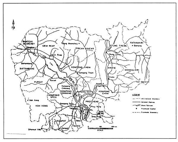
FIGURE 1
Provincial map of Cambodia
During the peak monsoon from about the end of May each year, the capacity of the Mekong is inadequate to convey the flood waters, and the water level at the Mekong/Tonle Sap confluence rises to about nine metres. At this time of year the flow direction in the Tonle Sap reverses and flood water from the Mekong flows to the Great Lake, thus adding to the flood runoff from the Great Lake catchment. The volume of water stored is some 72 x 109 m3. Concurrently the lake surface increases to more than 13 000 km2, inundating adjacent land for up to five months each year. When the Mekong reduces sufficiently, usually in October, the Tonle Sap reverses direction again and drains the stored flood waters from the Great Lake back towards the Mekong.
Review of hydrological services and flooding
Hydrological services prior to 1979
Under French colonial rule, systematic data collecting activities in both hydrology and meteorology were ongoing. Evidence is present at specific sites in the form of the remains of concrete foundations of former hydrological stations.
Following independence, Cambodia became a member of the World Meteorological Organization on 8 November 1955, and with the formation of the Mekong Committee in 1957, a systematic data collection program of hydrological data was set up. Data were regularly collected, checked and stored in a database at the Mekong Secretariat in Bangkok. Compiled data were published annually as Hydrological Year Books.
In the years before 1975, hydrological data collection was implemented by the former Department of Hydrology and Navigation under the Ministry of Public Works. At that time a total of 31 hydrological stations were in service.
Between 1975 and 1979 the National Hydrological Services were abandoned, resulting in complete disruption of the entire hydrological network and data collection.
Hydrological services after 1979
The present General Directorate of Irrigation, Meteorology and Hydrology (GDIMH) was established in 1979 as the Department of Hydrology (DoH) and renamed as the Department of Agricultural Hydraulics and Hydro-Meteorology (DAHHM) in 1993, under the Ministry of Agriculture, Forestry and Fisheries (MAFF). Hydrological and meteorological services were joined in the Hydro-Meteorological Office.
During the 1980s DoH received assistance in the form of technical advice, training and equipment from the Soviet Union and Viet Nam. The situation was extremely difficult due to the continuing state of war, poor security, minimal budget and international embargo on Cambodia. Russian instruments were brought in and installed at selected stations. Thirteen river gauging stations were re-established through this support.
From September 1995, a sub-decree from the first and second prime ministers changed the organization, from the DAHHM to the GDIMH, under the direct control and leadership of the MAFF. The Directorate is divided into six departments:
The new status reflects the importance of the DoH having the following responsibilities:
Hydrological network
Since April 1996 there has been a basinwide project entitled “Improvement of the Hydro-Meteorological Network (IHMN),” funded by the Government of Japan and implemented by the MRC Secretariat. Its objectives are:
to rehabilitate and/or construct an adequate number of hydrometeorological stations in Cambodia, and to reinforce, as a the first priority, existing basinwide stations to ensure an effective physical infrastructure base for data collection;
to develop regular measurement, collection and dissemination (forwarding) procedures for hydrometeorological data with time-lag closer to real time from an operational, maintained and reinforced network; and
to improve the management of the data collection network, the interpretation and use of information by the national agencies concerned in the riparian countries through adequate training.
Specific activities include:
conducting workshops, etc. to encourage use of hydrometeorological data in water resources programmes.
FIGURE 2
Series of maximum and minimum water levels of Bassac at Chak Tomuk
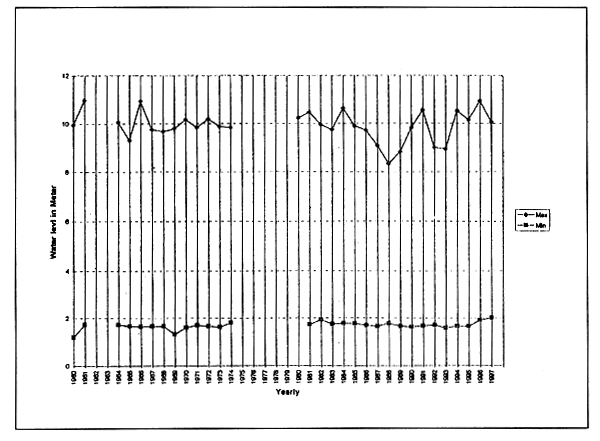
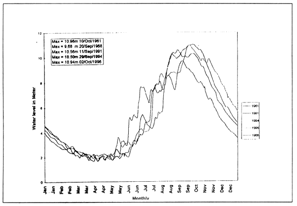
FIGURE 3
Hydrographs of the Bassac River at Chak Tomuk
In total 58 hydrological stations have been selected for river observations in Cambodia, of which 28 have been improved by means of the IHMN inside Cambodia, while 30 other stations have been included in the future improvement plan of the DoH/GDIMH.
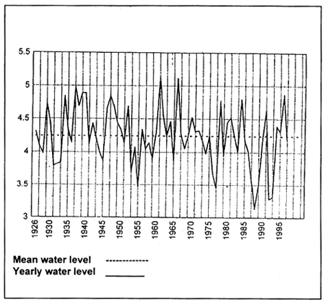
Maximum and minimum water levels from 1960 to 1997 at Bassac-Chak Tomuk are shown in Figure 2. The floods of recent years show on upward cycle in 1991, 1994, 1995 and 1996. The 1961 flood achieved the maximum water level during the past 35 years. However, the 1991, 1994 and 1996 floods were nonetheless exceptionally serious on the Mekong. Figure 3 shows the hydrograph of maximum water levels in 1961, 1991, 1994 and 1996. The year 1968 represents the mean of maximum years, throughout the series of maximum and minimum water levels. The frequency curve of maximum water levels at Bassac-Chak Tomuk is shown in Figure 4.
Floods occur during the rainy season throughout the country when rainfall is above average from August to November. Areas affected in the north include Rattanakiri, Stung Treng, Kompong Cham and Kratie provinces, in the north-west Battambang, Pursat and Bantey Meanchey provinces, in central and south-east Kandal, Prey Veng, Phnom Penh, Takeo and Svay Rieng provinces, and the coastal zones of Kampot province. Total economic losses from water related disasters during September to October 1995 and 1996 are shown in Tables 1 and 2.
Flood management and mitigation
Method of hydrological forecasting
In Cambodia engineers and technicians are based at the Department of Hydrology headquarters, and are responsible for regular maintenance of gauging stations, upkeep of the database for observed data, as well as for discharge measurements and flood prediction. Some DoH staff members are assigned to the six most important stations to manage works directly (see Figure 5). Observations at most of the stations are, however, carried out by part-time observers on contract who provide data to GDIMH directly or through provincial IMH office on demand.
FIGURE 4
Frequency curve of maximum water level of the Bassac at Chak Tomuk
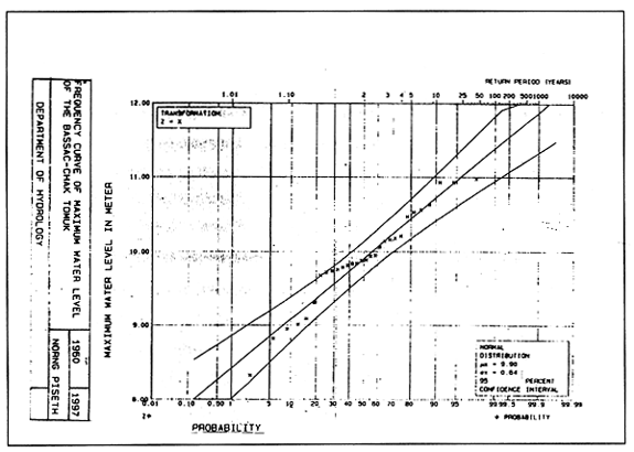
TABLE 1
Report of flood victims in 1995
| Flood-affected areas | # Fam affected | Rice field (ha) | People | House & school | Cattle-poultry | Other crops (ha) | Others | |||||
|---|---|---|---|---|---|---|---|---|---|---|---|---|
| Province | District | # Commune | Flooded | Damaged | Injured | Dead | Flooded | Damaged | Pigs dead | |||
| Battambang | Ek Phnom Mong Russey Banan Battambang Sanke Barvel | 7 11 8 10 5 6 | 4254 3178 6048 2466 | 3511 25778 10549 17547 | 1843 14368 3727 10263 5807 3000 | 1 8 1 1 | 5651 | 112 181 104 9 | 5 175 8 6 33 | 530 | ||
| Sub-total | 47 | 15948 | 57385 | 39008 | 11 | 5651 | 406 | 227 | 530 | |||
| Pursat | Bakan Phnom Kravang Kandieng Sampeov Meas | 10 7 9 7 | 3112 2758 3990 2021 | 29801 2252 6761 4417 | 6247 1099 2196 | 5 3 2 | 2932 675 496 | 27 157 5 208 | 13 28 5 4 | |||
| Sub-total | 33 | 11881 | 34231 | 9542 | 10 | 4103 | 397 | 50 | ||||
| Phnom Penh | Dangkor Mean Chey | 9 1 | 2792 228 | 2360 | 1353 | 1918 | 24 | 41 | ||||
| Sub-total | 10 | 3020 | 2360 | 1353 | 2146 | 24 | 41 | |||||
| Kratie | Chlong-Kratie | 220 | 1971 | 220 | 52 | |||||||
| Sub-total | 220 | 1971 | 220 | |||||||||
| Takeo | Kirivong Angkor Borey\ Borle Chulsar | 2516 | 3608 | 2516 | ||||||||
| Sub-total | 2516 | 3608 | 2516 | |||||||||
| Grand total | 33585 | 93976 | 55482 | 21 | 14636 | 855 | 301 | 571 | ||||
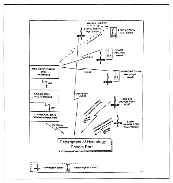
The most important task for hydrologists in Cambodia is flood prediction, especially the forecasting of floods which might affect Phnom Penh. This is the central reason of existence of the Department. Data from major stations on the mainstream (on the Mekong River at Stung Treng, Kratie, Kompong Cham and Bassac) must be transmitted by radio daily during the floods from September to November.
TABLE 2
Report of flood victims in 1996
| Flood-affected areas | # Fam affected | Rice field (ha) | People | House & school | Cattle-poultry | Other crops (ha) | Others | |||||
|---|---|---|---|---|---|---|---|---|---|---|---|---|
| Province | Families | Flood people | Flooded | Damaged | Injured | Dead | Flooded | Damaged | Pigs dead | |||
| Rattakan | 3322 | 17410 | 2583 | 2583 | 3 | 118 | 1394 | |||||
| Stung Treng | 9171 | 51781 | 5958 | 5958 | 3 | 253 | 8 | 1045 | 30 | |||
| Kratie | 12280 | 71333 | 6588 | 6588 | 4 | 78 | 9 | 876 | 41 | |||
| Kompong Cham | 94084 | 519632 | 58107 | 28991 | 856 | 53 | 4528 | 89 | ||||
| Phnom Penh | 12392 | 6270 | 18 | 330.5 | ||||||||
| Kandal | 64396 | 332559 | 16241 | 14826 | 18 | 583 | 73 | 7155 | 68 | |||
| Prey Veng | 89417 | 458437 | 80885 | 80885 | 75 | 1044 | 1283 | |||||
| Svay Rieng | 19509 | 100343 | 17876 | 17876 | 4 | 55 | 252 | 21 | ||||
| Takoe | 28479 | 149814 | 29712 | 29712 | 34 | 291 | 272 | 595 | ||||
| Kompot | 2377 | 12104 | 3811 | 3811 | 200 | 7 | ||||||
| Pursat | 24535 | 120545 | 37131 | 37131 | 8 | 120 | 1596 | 1168 | 17 | |||
| Battombang | 19369 | 98189 | 20173 | 20173 | 6 | 167 | 149 | 135 | ||||
| Banley Meanch | 6801 | 35641 | 4250 | 4250 | 192 | 214 | ||||||
| Sub-total | 386'32 | 1967788 | 289585 | 252784 | 155 | 3957 | 1906 | 17039 | 2151 | |||
Material damage in monetary terms: 2700 R = one DUS; 231248553200R = $ 8564716
Flood prediction. As indicated above, flood prediction is the most important activity of the Department. Therefore, the DoH has organized almost real-time data transmission during the flood season, while flood prediction is done as explained below.
On a daily basis, water level data as of 0700 hours on the day and 1900 hours on the day before is transmitted to the DoH by radio or otherwise by observers, and it is also transmitted to the MRC Secretariat by radio. The Secretariat collects data from primary stations along the main stream in Lao, Thailand, Cambodia and Viet Nam, forecasts the change of the water level by mathematical model and sends the result to the four riparian countries by facsimile. Since no data is obtained from the main tributaries in Cambodia, the result is not always reliable. Insufficient data limits the accuracy of the model analysis. On the other hand, the Department also makes its own forecasts, mainly based on local experience of the floodwaters flowing downstream from Stung Treng, Kratie, Kompong Cham and Phnom Penh on a daily basis. These forecasts are worked out by hydrograph routing (manual calculation) based on the 0700 hour observations of water level at five stations with real-time data transmission and updating the time-series of water levels at the station where observations are collected.
During the flood season of 1998, the hydrological Flood Forecast Model (FFM) will replace hand calculation. The FFM was written as a macro in Visual Basic for Microsoft Excel. It enables the Department to predict the flood levels with a propagation time of one day only. There are only three models for flood forecasting: namely “the Sogreah Model analysis”, and Regression and Autoregression analyses. These were applied to compute flood forecasts in Cambodia. The simulation of seven-year flood forecasting periods (July-October) was performed to test the FFM. As the result, the simulated forecasts are in good agreement with the observed levels.
Public awareness and mitigation measures
The end users of hydrological forecasts and real-time data are:
FIGURE 5
Cambodian national communication structure
Flood recession schemes with storage. In this type of scheme, the area is inundated during the wet season. The main source of water for the storage reservoirs is flood water with little contribution from the streams in the catchment which dry up during the dry season. As the flood waters recede, exposed land is cultivated. Irrigation is done with water from the reservoir, but supplementary water sources may also be used.
Flood recession schemes with direct river obstruction. In this type of scheme the area is also inundated during the wet season. As the floods recede, the exposed land is cultivated. There are no storage reservoirs and irrigation is done by direct abstraction from the rivers. The rivers feeding these schemes are influenced by tides and also serve as navigational channels in the area.
Disaster prevention and preparedness activities
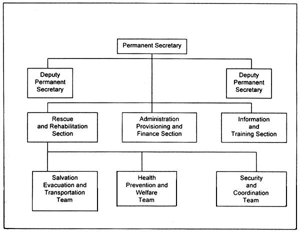
The existing framework of flood forecasting and response was established by the National Committee of Disaster Management of the Royal Government of Cambodia in March 1995. The Committee has the Co-Prime Ministers as chairman., the Co-Ministers of Interior as vice-chairman and 13 related Ministersas members (see Figure 6).
FIGURE 6
Organigram of the Secretariat of the Cambodian National Committee of Disaster Management
Conclusion
Hydrology is important not only for flood prediction but also as the method of acquiring basic data required for all water resources development and related projects. Even if hydrological activities do not make direct profit, they do contribute to alleviate flood damage. No plan can be prepared without hydrological data.
What are the constraints and other factors affecting the practice of hydrology in Cambodia? Aspects of hydrological activities in Cambodia in the past and the present, which may well affect the future of Cambodian hydrological practice, are ordered as follows:
All the factors mentioned above are related. Improvement in each category is extremely urgent not only for the country itself in terms of water resources development and related fields, but also in the continuity of gathering observed hydrological data serving as the fundamental base for sustainable development in the Mekong Basin countries. Hydrological data - its continuity and quality - also serve as the key basic instrument for the Water Utilization Program and other projects.
General background
Thailand is a Southeast Asian country comprising 76 provinces with 60 million inhabitants, lying in the tropical zone within latitude 5°37' N and 20° 27 N and longitude 97° 22'E. The country covers an area of 514 000 km2, is some 1 650 km from north to south, and is 770 km from west to east. The narrowest portion is only 15 km across. Thailand is situated in the Indo-Chinese Peninsula, sharing borders with Myanmar to the west and north, Laos to the east and north, Cambodia to the east and Malaysia to the south.
Topographically, Thailand is characterized by mountains in the north which continue to the south-east; flat alluvial plains intersected by winding rivers and irrigation canals which flood during the rainy season; a certain amount of undulating country; and maritime features such as sandy beaches, mangrove swamps, irregular coastlines and numerous islands.
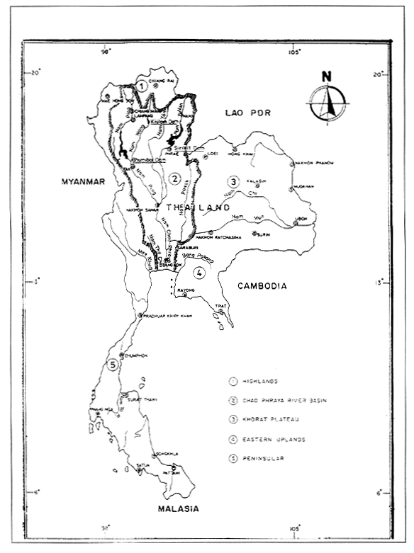
Physiographically, the country may be divided into five regions: the North (mountainous), Central Plain (Chao Phraya River Basin), the Khorat Plateau, the Eastern Uplands and the Southern Peninsula as shown in Figure 1.
Climate
Thailand has a tropical climate. The climate seasons are based on two major wind systems, the north-east and south-west monsoons, each with its own weather characteristics. The north-east monsoons, the dry and cool period, occur from mid-October to mid-February due to winds flowing from the north-east. The south-west monsoon, the wet period, occurs from mid-May to mid-September. Two transitional periods are in between the monsoons, from mid-February to mid-May due to the varying winds from the east and south-east, and during October, due to the replacing of the south-westerly wind by the north-easterly wind. In addition to monsoons Thailand is also subjected to tropical storms, the major source being the South China Sea, while secondary sources are the Western Pacific, the Gulf of Thailand and the Andaman Sea. They are born as typhoons, tropical storms and tropical depressions. Obviously the higher the moisture supply while moving over the water surface, the higher the severity of the typhoon. After losing its moisture supply while moving over the land surface, it then weakens and is finally dissipated.
Mean annual rainfall ranges from 1 000 mm near central North-eastern Thailand to 4 000 mm in the Truong Son mountains between the Lao PDR and Viet Nam. Some 80–90% of all rainfall occurs during the wet season.
Varunee Charoensamran, Senior Hydrologist, Hydrology Division, Department of Energy
Development and Promotion, Ministry of Science, Technology and Environment, Thailand
FIGURE 1
The five regions of Thailand
Mean annual rainfall in the various regions in Thailand are as follows: the North 1 241 mm, the Central Plain (Chao Phraya River Basin) 1 226 mm, Khorat Plateau 2 008 mm, and the Eastern uplands 1 406 mm and Peninsula 2 267 mm. Mean annual rainfall over all Thailand is 1 629 mm.
Major causes of floods in Thailand
Floods in Thailand are normally caused by tropical storms and depressions, rarely by typhoons. The tropical storm season is from about May to December. During the first two mouths and the last month of the season, the probability of storms occurring in the country is minimal. It rises during August to November, especially in September and October where the probability is maximum. Statistics of a46-year period (1951–1996) show that on average 3.5 storms occur annually, while 0.9 storms occur during the months September and October.
The most common storm track is westward from the north-east of Thailand. It causes heavy rain in its passage over land. The low-lying areas of the Central Plains usually have the flood condition according to the intensity of heavy rain during the storm season.
From early September to mid-November 1980, severe flooding was experienced over vast areas of northern, north-eastern and central Thailand, including the Bangkok Metropolis and adjacent areas,. It was apparently caused by excessive rainfall brought about by two depressions which occurred on 6 and 7 September and 17 September. The maximum 24-hour rainfall was 156 mm in Uttaradit Province in the north in September and 147 mm in Kalasin Province in the north-east on 15 September.
Including the active monsoon trough in upper Thailand during September and early October with those depressions, flooding in 47 provinces of upper Thailand and in one province in Southern Thailand affected 203 386 families, or 831 368 persons, whereas 2 394 houses were destroyed. A total of 61 persons were reported dead, with others injured during the flood events. It was estimated that about 928 000 hectares of farmland were damaged, from which about 12 000 families or 70 000 persons were evacuated to safe places. The total damage caused by the 1980 flood in upper Thailand, excluding the Bangkok Metropolitan area, was estimated at around 1 546 million baht. Flooding in the lower Chao Phraya River Delta areas, particularly in the Bangkok Metropolis, was prolonged from early October to mid-November. Damage incurred by the 1980 flood in the Bangkok Metropolis itself has been roughly estimated at many millions of baht. Thousands of urban residents were inundated. The 1980 flood is regarded as one of the most disastrous natural events ever recorded in Thailand.
In 1995, Thailand experienced very severe floods caused by the combination of tropical storm Lois, the south-west monsoon and low pressure systems. They caused major floods in upper Thailand including Bangkok Metropolis and adjacent areas during the period from mid-July to the end of September. A total of 64 provinces (15 provinces in the North, 19 in the Northeast, 17 in the Central plains, eight in the East and five in the South) were flooded. It was estimated that about 1.7 million hectares of farmland were damaged, which affected 1.4 million families or 5 million persons were affected. More than 12 000 houses were destroyed. There were 413 deaths and about 18 000 families or 60 000 persons were evacuated to safe places. The total damage in upper Thailand, excluding the Bangkok Metropolitan area, was estimated at around 10 545 million baht (US$421.8 million).
Besides the major cause of floods described above, the other causes that aggravate flood problems in flood plain areas include insufficient capacity of rivers and canals, poor drainage and sewerage systems in populated areas, destruction of forest, poor management of land, and the inadequacy of reservoirs. Especially for the Bangkok Metropolitan area, flooding in urban areas is due to heavy rain downpour in the area, overbank flow on the flood plain of the Chao Phraya River, tidal effect superimposed on the flood wave of the Chao Phraya River, land subsidence which is due to groundwater abstraction, obstruction of water ways by extension of the urban area and metropolitan irregularity, and destruction of public utilities.
Operations for flood damage mitigation in the Bangkok metropolis
Due to the severe damage caused by flooding in Bangkok in 1983, other measures were implemented for flood protection. Flood protection works for the Bangkok Metropolis included the construction of embankments, improvement of drainage canals, provision of drainage pumps, dikes and zoning. The effect of the project was studied and a diversion canal was built to discharge excess flow directly to the sea, together with preventing tidal effects by building a sea barrier in order to protect the city core of Bangkok from major flooding in 1995.
General description of water resources
Since Thailand's economy is principally based on agriculture, basic problems concern excess water in the rainy season and water deficiency in the dry season. The basic case of river flooding in Thailand is the incidence of heavy rainfall. Whenever peak discharge is greater than bank-full capacity, the river will overflow and inundate the flood plains. Flooding in the river and its tributaries occurs quite often. However, in some years rain is insufficient to replenish the supply of water in either the rainy or the dry season.
FIGURE 2
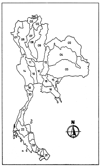
Location of 25 major river basins in Thailand
In general, the water resources of Thailand are abundant. Among Thailand's rivers the Chao Phraya river system is the most important - as a water resource which is the principal source of water supply to agriculture. Its waters are chiefly maintained by the flow of the major tributaries originating in the northern watershed.
The resources in the Northeast Plateau - an area of 170 220 km2, or about one-third of the country - were previously developed by the construction of reservoirs and irrigation works.
Substantial water resources development across the kingdom was rapidly expanded since 1951 with varied flood control, and drainage and irrigation projects. Many multipurpose reservoir projects for hydropower, irrigation, flood control, inland navigation and pollution control were undertaken.
FIGURE 3
Location of main rivers and dams in Thailand
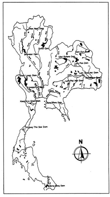
The first such project was built in the north on the Ping River in 1958. Named the Bhumiphol storage dam, it began operating in 1964. It has a capacity of 13 000 MCM. The second largest project, the Sirikit storage dam with a capacity of 10 000 MCM, was built on the Nan River and started operating in 1971. In addition to these twin large multi-purpose projects, development of water resources was carried out in various degrees with diverse social and economic applications elsewhere in the country. The total irrigated area covered some 3.0 million ha - 45% of the total cultivated land - while hydropower plants producing 1.95 million KW or some 32% of Thailand's total capacity were installed during this period.
Flood forecasting and warning activities
Floods are Thailand's most disastrous natural phenomena. As with other countries in the Southeast Asian region, the basic cause of severe flooding is found in the incidence of heavy rainfall. In many cases the most devastating flood-producing rainfall event is associated with cyclonic storms in the form of typhoons or depressions. The intensity of rainfall is high during such events and the storms are geographically extensive. These twin factors mean that such storms are capable of producing extreme flood discharges in both large and small river basins.
Seeking a means to mitigate the damages, a mathematical flood forecasting model was first introduced to the Chao Phraya River Basin in 1975. In 1981, the flood forecasting system for other river basins was established to a large extent, such as Nam Pong, Nam Chi, Nam Mun in the Northeast and Mae Khlong in the West.
Several government agencies and institutions are involved in developing and implementing hydrological forecasts. The Electricity Generating Authority of Thailand (EGAT) is responsible for reservoir regulation. The Royal Irrigation Department (RID) operates irrigation water utilities and flood control operations in cultivated areas, while the Meteorological Department (MED) prepares meteorological forecasts. In addition, the Mekong River Commission (MRC) the Department of Energy Development and Promotion (DEDP), the Bangkok Metropolitan Administration (BMA) and the Department of Local Administration (LAD) are involved in hydrological investigations for flood mitigation purposes.
Flood forecasting practice
Flooding is a natural hazard which affects national economic growth. During the past decade, Thailand encountered serious flooding problems in both cultivated and urban areas. The National Economic and Social Development Board (NESDB) therefore has been seeking solutions to the problem. One such solution is seen in modern technology on flood forecasting. The first flood forecasting system was established in the Chao Phraya River Basin as it is the major river contributing benefits to the country.
The Chao Phraya River Basin extends from the upper northern part of the country, consisting of a series of parallel mountain ranges drained by torrential rivers, namely the Ping, Wang, Yom and Nan. There are four main tributaries flowing south, where they meet together to form the Chao Phraya River. The Chao Phraya runs southward passing through the main cities and Bangkok, the capital before draining into the Gulf of Thailand. The drainage area of the basin is about 162 000 km2 and has a length from its source to the river mouth of about 1 000 km.
Normally, forecasts are made every five days. In addition, during flood-prone periods forecasts for shorter time periods (hourly or daily) are prepared.
Forecasts are disseminated to the appropriate government agencies. The purpose of the warnings is to stimulate the correct response from the forecast users; the real value of the forecasting system should be assessed on this basis. For this reason, feedback from forecast users to the forecasting office regarding the effectiveness of the forecast is important. Such information plays an important role in flood protection measures and water conservation in the reservoirs.
Flood forecasting and management in the Lower Mekong Basin in Thailand
General Background
The Mekong is the longest river in Southeast Asia and one of the largest rivers in the world. In terms of drainage area (795 000 km2), it ranks 21st, but in terms of runoff (475 000 MCM), it ranks 8th and 12th in terms of length (4 200 km). The Mekong River originates on the Tibetan Plateau and flows into the South China Sea over a distance of 4 800 km.
The Lower Mekong Basin begins where the river leaves China and becomes the border between the Lao PDR and Myanmar. It covers an area of more than 600 000 km2 which comprises the area drained in four riparian countries - almost the whole of Lao PDR, Cambodia, one-third of Thailand (its entire north-eastern region and part of its northern region) and one-fifth of Viet Nam (its Central Highlands and the Mekong Delta). It is inhabited by a population of some 50 million, representing approximately one-third of the total population of these countries.
Flood forecasting operations
Flood forecasting operations in the Lower Mekong Basin were initiated in 1970 by the Mekong Secretariat. The objective of flood forecasting is to provide information on the future state of a river in order to minimize the effects of flooding and provide warnings to those people who live in affected areas. Since then, this operation has been repeated annually.
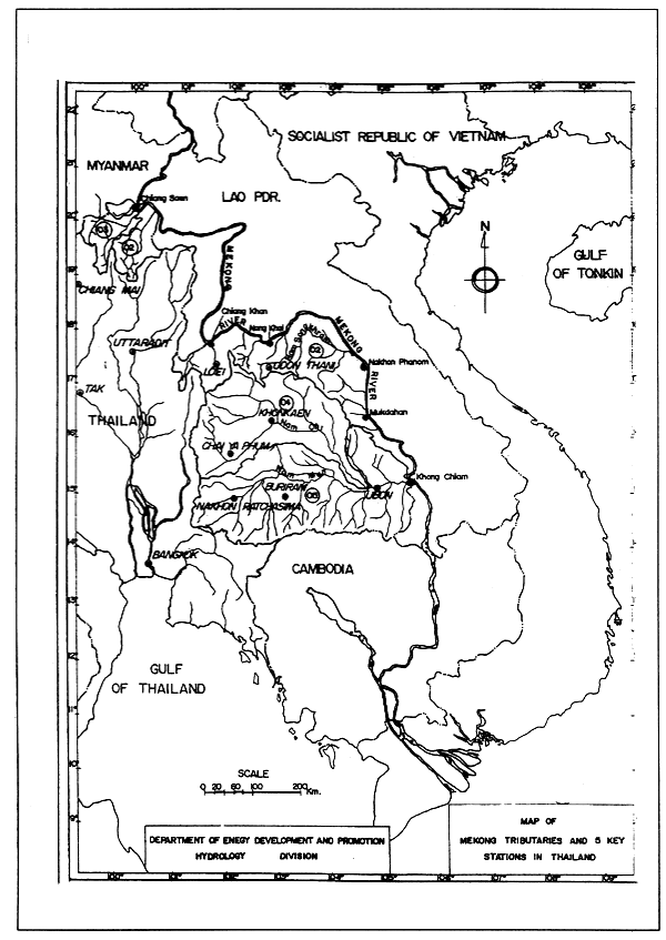
The Mekong Secretariat applied the Streamflow Synthesis and Reservoir Regulation (SSARR) model for forecasting on the upper and middle reaches of the Lower Mekong Basin, from Chiang Saen to Pakse, during the July-October flood season. The real-time information (water level and rainfall data) includes data from five key hydrological and meteorological stations in Thailand; namely at Chiang Saen, Chiang Khan, Nong Khai, Nakhon Phanom and Mukdahan (Figure 4) and five key hydrological and meteorological stations in the Lao PDR: Luang Prabang, Vientiane, Thakhek, Savannakhet and Pakse to be transmitted by radio or facsimile to the Secretariat daily at 1700 hours or, during peak periods twice daily, at 1100 and 1700 hours. Normally, the forecast is issued five days in advance.
Every afternoon at 1700 hours the consolidated forecast is transmitted to the National Mekong Committee in each riparian country.
Flood warnings
The Department of Energy Development and Promotion (DEDP) is the Thailand National Mekong Committee-related agency directly responsible for hydrological investigations, and flood warnings regarding the Mekong mainstream flooding in Thailand.
The DEDP prepares warnings and disseminates them to the appropriate government agencies, if the forecast indicates that water levels of the forecasting stations will reach critical stage. The DEDP responds as follows:
Disaster management in thailand
The Minister of Interior is the National Civil Defense authority for Thailand. According to the Civil Defense Act, 1979, disaster management covers both natural and man-made disasters. Thailand's Disaster Management System is divided into three levels of responsibility with authority as follows:
Policy and strategic response
Disaster policy and strategy is conducted in cooperation with government policy and the National Economic and Social Development Plan as follows:
FIGURE 4
Map of Mekong tributaries and five key stations in Thailand
Policy implementation
The Civil Defense Secretariat is responsible for implementation of the policies which the said committees have assigned by making the National Civil Defense Plan as the Disaster Master Plan for involved government agencies. This includes making guidelines in planning for operational units and by dictating practical procedures for each type of disaster, such as flood, storm, fire and drought.
Disaster mitigation
According to the Civil Defense Act of 1979, local authorities are responsible for creating preparedness for disaster, whereas mitigation in each administrative area remains the responsibility of the preparation unit. However, after budget constraints and reduction of government equipment costs in local administrative areas, Thailand has improved its disaster mitigation system on a regional basis by setting up units at three operational levels: Emergency Units, Main Units and Support Units. They are responsible for designated areas in Bangkok and the provinces.
Natural disasters in thailand
Risk assessment
Thailand is fortunate that it does not experience significant natural disasters as in many other countries in the region. However, there are some natural hazards which have a potential to create great destruction such as floods, typhoons and storm surges, and strong winds.
As indicated in Table 1, there is both a high probability for flooding and a high likelihood of risk. However, although typhoons and storm surges occur less frequently their rate of risk is higher than that of flooding
TABLE 1
Risk assessment
| Type | Frequency of occurrence | Rate of risk | Risk area |
|---|---|---|---|
| Floods | High | High | Countrywide, especially northern, central and southern regions |
| Typhoons and storm surges | Low | Moderate | Southern region |
| Strong winds | High | Low | Countrywide |
Table 2 presents details on losses experienced in the years 1990–1995. Economic costs are given in Thai baht(25 Thai Baht = 1 US dollar)
TABLE 2
Disaster situations in 1990–1995 because of floods
| Year | No. of Provinces | No. of deaths | No. of injuries | Loss (million Baht) |
|---|---|---|---|---|
| 1990 | 58 | 50 | 19 | 6,652 |
| 1991 | 66 | 43 | 26 | 2,621 |
| 1992 | 66 | 16 | - | 5,241 |
| 1993 | 11 | 47 | 254 | 2,182 |
| 1994 | 74 | 59 | 12 | 6,044 |
| 1995 | 73 | 442 | - | 11,859 |
Conclusion
Thailand has established the Office of the National Water Resources Committee to manage water resources in its major river basins as part of a master plan for water utilization, water conservation, water quality control, flood protection and water law.
Background
Flooding is a major problem which severely affects all the Mekong River riparian countries. With the lowest areas of the Mekong Basin, Viet Nam's land is flatter, flooding is more frequent - and the areas flooded are larger.
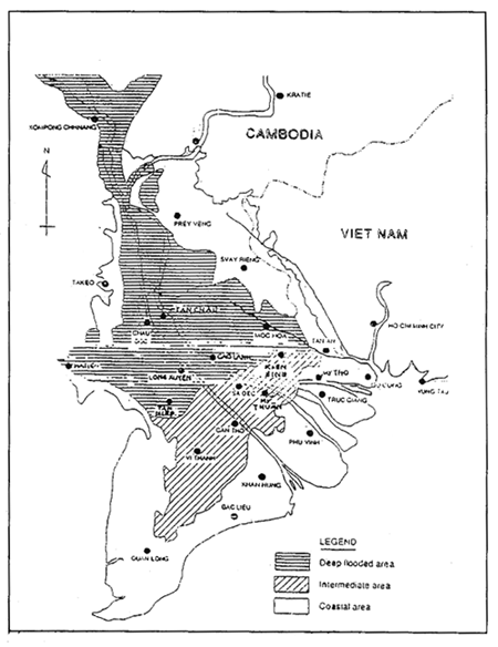
The network of inter linking rivers is complex. At Phnom Penh the Mekong River meets the Tonle Sap and then branches into the Mekong (Tien) and Bassac (Hau) rivers before entering Viet Nam. The two rivers themselves branch into many tributaries with natural streams and a dense network of man-made canals. Moreover, the area has other important rivers such as the Vain Co Dong and the Vam Co Tay (see Figure 1).
FIGURE 1
Location of the Mekong Delta
The flood season extends from June to November, with 80% of the annual flow volume occuring during this period. There are two types of flooding which affect the area: one being floods from the upstream Mekong Basin, while the other one is tidal water from the Bien Dong Sea (South China Sea) known as tidal flooding.
Le Thi Tam Thien, Deputy Chief, Hydro-Met, Forecasting & Services Division,
Southern Centre for Hydro Meteorological Forecasting, Ho Chi Minh City, Viet Nam
Flooding occurs annually in varying degrees and frequency, from June to November. The early flood occurs during June and July, while the main flood occurs from late August to October and causes flooding in the area with different levels. Every year, more than 1 million ha are flooded, with depths of up to 3.5 m of water, and durations of more than three months.
Apart from flooding in the rainy season, there is flooding which occurs in the coastal areas during the dry season. This is caused by tidal waters from the Bien Dong Sea. Such salt water flooding causes damage to fruit trees and freshwater products by increased salinity.
While flooding causes damage, it also brings benefits.
In recent years, the Government of Viet Nam has given much attention to the above mentioned problems. Many reports were submitted to the Government to find ways to reduce the damaging impact and to make the most of positive effect of flood for the area.
View of flooding
Flooding situation
Mekong Delta flooding occurs as a consequence of three different effects, often in combination with one another:
In general, the early flooding is mainly a result of the high discharges by river from Cambodia, which may cause inundation at some locations upstream, while main flooding is caused by all the factors that cause inundation over large areas.
The areas known as the Plain of Reeds and the Long Xuyen Quadrangle are especially flood prone. In previous years, these areas have experienced flooding every year and severe flooding two or three times a decade. There is a close correlation between flooding and more widespread inundation.
In recent years, with the area's boom in economic development, human activity has changed the correlation. Severe inundation now occurs even in the years of moderate flooding on the mainstream.
Severe floods were experienced in 1961, 1966, 1978, 1984, 1991, 1994, 1995, and 1996. (see Table 1 and Figure 2). The 1996 flood was the most severe. At that time all three effects mentioned were present: high water levels on the Mekong River, high tides in the Bien Dong Sea, and heavy rainfall in the area.
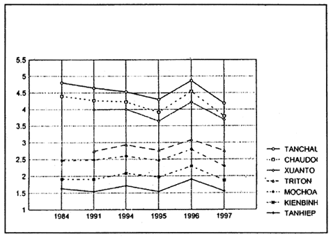
TABLE 1
Annual maximum water level at different stations
| Year | Tanchau | Chaudoc | Xuanto | Triton | Mochoa | Kienbinh | Tanhiep | DiffTC-MH | |
| 1 | 1984 | 4.80 | 4.40 | 2.46 | 1.91 | 1.63 | 2.34 | ||
| 2 | 1991 | 4.64 | 4.27 | 3.99 | 2.74 | 2.48 | 1.90 | 1.54 | 2.16 |
| 3 | 1994 | 4.53 | 4.23 | 4.00 | 2.93 | 2.59 | 2.08 | 1.71 | 1.94 |
| 4 | 1995 | 4.30 | 3.91 | 3.64 | 2.76 | 2.46 | 1.97 | 1.54 | 1.84 |
| 5 | 1996 | 4.86 | 4.54 | 4.22 | 3.08 | 2.79 | 2.219 | 1.90 | 2.07 |
| 6 | 1997 | 4.18 | 3.79 | 3.68 | 2.75 | 2.29 | 1.87 | 1.55 | 1.89 |
Usually, the water level at the main stream of the Mekong Delta begins rising in June or July. At that time if the water level at Tan Chau station (upstream) is over 2.20 m, there is early flooding causing severe damage to both summer and fall crops.
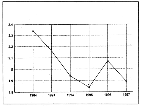
FIGURE 2
Annual maximum water level at Tan Chau
Heavy rainfall often occurs in the Mekong Basin beginning in August. Water levels rise quickly and reach their peak between the end of August and October. Flood waters in the field rise and recede later than floods in the main stream. An example is shown in Figure 3.
FIGURE 3
Daily maximum water levels at Tan Chau Station (m)
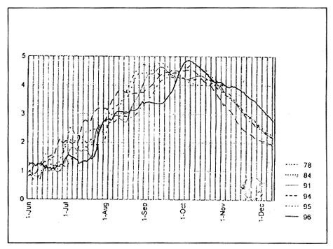
Currently it is difficult to estimate the flooding base from water levels at Tan Chau. The difference between the water levels at Tan Chau, Moc Hoa and the field stations has tended to become smaller year by year (see Figures 4 and 5). In 1995 the maximum water level at Tan Chau was 4.30 m, 12 cm higher than the mean, but water levels at Moc Hoa were 73 cm higher than the mean.
Damage
Loss of life has been increasing in recent years - 672 in 1994, 379 in 1995, 410 in 1996 and 607 in 1997 (see Table 2). More than half a million homes were damaged by the floods of 1994, while some 839 000 homes were carried away by floods in 1996.
Flood forecasting problems
Inaccurate flood forecasting can be attributed to six groups of causes:
FIGURE 4
Yearly maximum water level (m), compared
Flood management
Rapid economic development has brought increased settlement in the area, increased development of infrastructure such as the system of roads, embankments, dikes around villages, etc., which has adversely affected the capacity of the drainage system. This situation makes rural flooding deeper and longer in duration. This is shown for the years 1978 and 1996 in Figures 6 and 7.
FIGURE 5
Difference in water level, Tan Chau, Mochoa (m)
Most important now is how to manage floods to minimise damage and to attempt to derive some positive benefit from the flood for that population which has accepted to live their lives in an environment of endemic flood conditions.
Two basic approaches to flood management have been suggested by Vietnamese scientists: structural and non-structural measures.
TABLE 2
Total damage of severe flooding 1978–1997
| Unit | 1978 | 1984 | 1991 | 1994 | 1995 | 1996 | 1997 | ||
|---|---|---|---|---|---|---|---|---|---|
| 1 | Human loss (children) | Person | 87 | 105 | 158 | 407 265 | 199 180 | 250 160 | 607 |
| 2 | Damaged house | Family | 57 005 | 41 835 | 185 127 | 593 107 | 26 326 | 42 150 | 99 238 |
| 3 | House carried away by flood | Family | 9 005 | 8 219 | 12 350 | 2 799 | 28 240 | 839 686 | 74 368 |
| 4 | Households migrated | Family | 245 500 | 10 744 | 15 600 | 20 125 | 11 431 | 39 378 | |
| 5 | Rice areas entirely damaged | ha | 307 100 | 175 626 | 171 898 | 26 868 | 11 101 | 60 368 | 19 758 |
| 6 | Rice areas with yield decrease | ha | 113 600 | 111 879 | 88 873 | 202 186 | 62 399 | 132 309 | 251 341 |
| 7 | Estimated damage | thousand million VND | 1 261 | 1 247 | 883 | 2 284 | 700 | 2 673 | 6 966 |
* The data of 1997 include the damage caused by flooding and by typhoons.
FIGURE 6
Flood zone in the Mekong Delta 1978
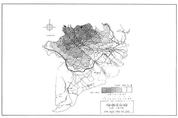
FIGURE 7
Flood zone in the Mekong Delta 1996
Non-structural measures
Upgrade the quality of hydrometeorological measurement and data collection and transmission basinwide by implementation of the hydrometeorological network and develop cooperation between riparian countries.
Strengthen the capability of flood forecasting, as well as the meteorological forecasting and warning network, especially in the medium and long term. This includes the estimate of stage, discharge, time of occurrence, and the duration of floods and may involve action to protect property from flood damage and/or evacuation planning. In some situations, flood forecasting and warning can be the most important non-structural measure in the management of flood-liable lands and in reducing flood losses. The value of flood forecasting and warning to the management of flood-liable lands is direct and can prevent i loss of life and material damage to property.
Provide public information and education, covering development of needed technical information and public education programmes, especially for officials and planners who have the main task of interpretation and application. This is essential in an effective flood loss prevention programme.
Inform people living in the flood path so that they may adjust themselves.
Diversify activities to get higher income before, during and after the flood by applying integrated farming systems (crop, livestock and fish) or sloping agricultural techniques.
Improve land use management including adjusting cropping patterns by selecting shorter duration crop varieties and earlier crop establishment to avoid predictable floods.
Modify catchment conditions such as on-site storage for use in the dry season.
Increase flood proofing of buildings. Some damages from flooding may be minimised by appropriate measures to prevent floodwaters from entering properties.
Intensify flood fighting, which has been generally defined as taking precautionary measures against disaster at times of flooding or surge water.
Structural measures
Levees and flood walls: the principal purpose of levees and flood walls is to protect only the area immediately behind them against a pre-determined flood height in early floods for which they were designed. These areas may include settlements or limited crop areas.
Channel modifications, which include straightening, deepening or widening of the channel, removing vegetation or debris, lining the channel, raising or enlarging bridges and culverts which restrict flows, and removing barriers which interfere which flows.
By-pass flood-ways, including those natural (existing) watercourses and man-made channels. New construction must take note of such conditions.
Building infrastructure and drainage systems to improve drainage of water originating as run-off from the protected area behind levees of flood walls.
Conclusions
Year by year, the severity of flooding damage in the delta becomes higher and higher, resulting in human loss and very serious and costly damage to infrastructure damage.
Apart from the harm as mentioned, there are positive effects of flood which are important. The floods mainly benefit future rice production, increase soil fertility, wash out soil acidity, and decrease damage by rats while increasing rice yields.
The policy of the Government of Viet Nam is to accept flooding as a normal and natural phenomenon and to accept to live with it. This requires an urgent re-orientation of flood management in the delta.
At present, some of the above mentioned measures of flood management which are financed by the Government are being tested.
In the opinion of flood forecasters, our hydrometeorological activities are most necessary for flood management in Viet Nam.
![]()
![]()