![]()
![]()
![]()
Background
The Lao PDR has experienced a range of floods of different magnitudes and duration. Particularly in three consecutive years - 1994, 1995 and 1996 - the floods were large and disastrous. This flood pattern indicates that, on average, a flood occurs in Lao PDR every 1.4 years and a disastrous flood every six years. The 1994 flooding of the Mekong River and its tributaries damaged about 28 000 ha of cropped land, but the floods which occurred during August-September 1995 and 1996 were the worst since 1966. Both can be regarded as major disasters for the agricultural sector in Vientiane Prefecture and the provinces of Vientiane, Borikhanhxay, Khammouane, Savannakhet and Champassak.
According to Government of Lao (GOL) estimates, up to 87 300 ha were inundated in 1995 and an estimated 104 000 ha in 1996 causing the complete loss of up to 62 000 ha of paddy in 1995 and 76 000 ha in 1996. There were considerable losses of other crops, livestock and fishponds while serious damage was caused to irrigation works and other infrastructure.
Available data on areas affected by the 1995 and 1996 floods is both sketchy and inadequate, and it has not been gathered in a scientific manner. Damage caused to human life, livestock, agriculture and infrastructure needs to be determined more accurately both in terms of quantity and cost from detailed field surveys of the affected areas.
Field survey and mapping
In each district/village/area visited, the following data on the floods of 1995 and 1996 were collected from local farmers. All information was plotted on aerial photographs or entered into survey questionnaires while survey personnel were still in the village. Data included:
Boonthian Oondara, Head, Flood Management Unit, Department of Irrigation,
Ministry of Agriculture and Forestry, Vientiane, Lao PDR
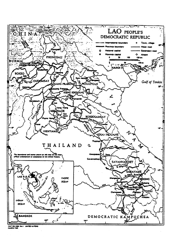
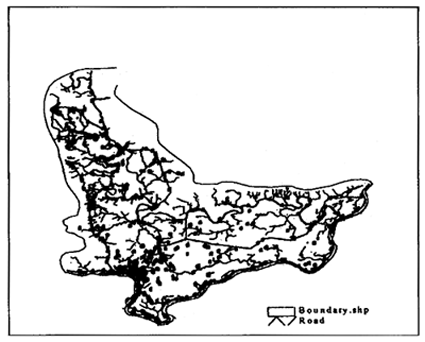
MAP 1
Map of the Lao People's Democratic Republic
Members of the survey teams were asked to assess from the same sources - including the Department of Irrigation (DOI), farmers and/or other local residents - all relevant information for the survey. This would include losses, damages and injuries caused to human life, livestock, rural infrastructure (including irrigation water schemes), residential and other buildings and agriculture (paddy and other crops) as well as major disruptions or diseases suffered by the local population during the flooding and following the receding of the floodwaters. Each loss was assessed both in terms of quantity (number of hectares flooded or the number of houses damaged) and financial costs and was entered in the questionnaire.
Survey staff identified, wherever possible, repairs and rehabilitation that was done (or had become necessary to do) to be carried out as a priority.
Collected data were reviewed for consistency and accuracy on a daily basis. Data inventory personnel were instructed to undertake the surveys neatly and legibly. Surveys were corrected in the field when review procedures were carried out. The questionnaires were completed to facilitate subsequent computerization of the data.
Data contained in the field survey questionnaires and aerial photos were then transferred to 1:50 000 maps.
Essentially, the fieldwork consisted of filling in a standard questionnaire with data on the depth and duration of flooding and delineating on the available 1:30 000 aerial photographs, mainly from visual inspection, data to indicate the extent of flooding in each village, district or area visited. Flood plain mapping comprised the transfer of information on flooded areas, depths and duration from the aerial photographs to the 1:50 000 maps used for mapping in 10 m increments. Delineation of flooded areas on the maps was approximate and was carried out by interpolation of levels between two consecutive contours.
Area surveyed
The area surveyed mainly comprised the lowlands of the Mekong River flood plain, although some upland areas were also flooded during 1995 and 1996. Data supplied by the Department of Irrigation on flooded areas and damage include upland areas as well. The districts covered by the survey in each province are seen in Table 1.
TABLE 1
Provinces, number of flood-affected districts and district names
| Vientiane | 3 | Keo Oudom, Phonh Hong, Thoulakhom |
| Vientiane Municipality | 8 | Nasaithong, Sikhottabong, Chanthabury, Sisattanak, Xaysettha, Xaythany, Pak Ngum, Hatsaifong |
| Bolikhamxai | 3 | Thaphabath, Paksane, Pakkading |
| Khammouane | 3 | Thakhek, Nongbok, Sebangfay |
| Savannakhet | 4 | Xayboury, Champhone, Songkhone, Xonhboury |
| Champasak | 8 | Sanasomboune, Pakse, Phonhthong, Pathoumphone, Champasak, Soukhuma, Moulapamok, Khong |
Flood survey results
The flood survey results are presented in Tables 1–5. It appears from Table 5 that the data on affected areas supplied by the Department of Irrigation (DOI) may not have been accurate.
TABLE 2
Lao PDR: flood loss prevention and management plan. Results of field survey of flood affected area. Section A: 1995 floods. Section B: 1996 floods
| PHYSICAL DATA | FLOOD DATA | HIGHEST FLOOD | AGRICULTURE LOST | LIVESTOCK LOST | INFRASRUCTURE LOST | TOTAL LOSS | |||||||||||||||||
|---|---|---|---|---|---|---|---|---|---|---|---|---|---|---|---|---|---|---|---|---|---|---|---|
| Villages No. | Households No. | Population | Flood Year | Depth m | Duration Weeks | Date Month/Yr | Magnitude m3/sec | Paddy Area ha | Paddy Yield Lost | Other Crops Area ha | Crop Yield Lost | Total No. | Cost mill. Kips | Irrigation Total No. | Cost mill. Kips | Million Kips | Million US$ | ||||||
| Total | Affected | Lost | Tonnes | Cost mill. Kips | Total | Affected | Lost | Tonnes | Cost mill. Kips | ||||||||||||||
| 1 | 2 | 3 | 4 | 5 | 6 | 7 | 8 | 9 | 10 | 11 | 12 | 13 | 14 | 15 | 16 | 17 | 18 | 19 | 20 | 21 | 22 | 23 | 24 |
| Vientiane Province: | |||||||||||||||||||||||
| 185 | 11,187 | 55,689 | 1995 | 0.5–8.0 | 1–6 | 8–9/95 | Nam Ngum: 2,500 Nam Lik: 3,000 | 20,653 | 10,346 | 10,346 | 25,865 | 5173.00 | 7,208 | 3,659 | 3,659 | 1 | 2479.50 | 26,447 | 307.40 | 1 | 3.50 | 7963.40 | 7.96 |
| Vientiane Prefecture: | |||||||||||||||||||||||
| 302 | 15,416 | 97,709 | 1995 | 0.5–8.0 | 1–8 | 8–9/95 | Mekong: 20,750 | 40,489 | 24,124 | 20,614 | 51,535 | 10307.00 | 9,958 | 676 | 544 | 1 | 2720.00 | 9,259 | 179.07 | 42 | 156.00 | 13362.07 | 13.36 |
| Bolikhamxal: | |||||||||||||||||||||||
| 115 | 10,736 | 56,261 | 1995 | 2.0–8.0 | 2–3 | 8/9–95 | Mekong: 29,000 | 11,088 | 9,097 | 8,088 | 20,220 | 4044.00 | 77 | 57 | 57 | 1 | 285.00 | 5,956 | 39.95 | 6 | 14.00 | 4382.95 | 4.38 |
| Khammouane: | |||||||||||||||||||||||
| 125 | 12,667 | 71,961 | 1995 | 1.0–6.0 | 1–7 | 9/95 6/95 | Mekong: 32,700 Sebangfai: 2,900 | 14,747 | 8,846 | 7,321 | 18,303 | 3660.50 | 112 | 112 | 112 | 560 | 56.00 | 2,470 | 350.26 | 12 | 123.00 | 4189.76 | 4.19 |
| Savannakhet: | |||||||||||||||||||||||
| 149 | 14,892 | 85,818 | 1995 | 1.0–8.0 | 1–6 | 9/95 6/95 | Mekong: 34,500 Sebangfai: 2,900 | 4,761 | 3,949 | 3,455 | 8,638 | 1727.50 | 16 | 16 | 16 | 80 | 8.00 | 442 | 8.71 | 6 | 35.00 | 1779.21 | 1.78 |
| Champassak: | |||||||||||||||||||||||
| 414 | 22,255 | 167,460 | 1995 | 1.0–5.0 | 1–3 | 16/09/95 | Mekong: 42,400 | 29,848 | 11,212 | 7,492 | 18,730 | 3746.00 | 0 | 0 | 0 | 0 | 0.00 | 231 | 50.00 | 0 | 0.00 | 3796.00 | 3.80 |
| TOTAL: | |||||||||||||||||||||||
| 1,290 | 87,153 | 534,898 | 121,586 | 67,574 | 57,316 | 143,290 | 28,658 | 17,371 | 4,520 | 4,388 | 640 | 5548.50 | 44,805 | 935.39 | 67 | 331.50 | 35473.39 | 35.47 | |||||
| B. 1996 FLOODS | |||||||||||||||||||||||
| Vientiane Province: | NEGLIGIBLE | LOSS | |||||||||||||||||||||
| 0.00 | 0.00 | 0.00 | 0.00 | 0.00 | 0.00 | ||||||||||||||||||
| Vientiane Prefecture: | NEGLIGIBLE | LOSS | |||||||||||||||||||||
| 302 | 0.00 | 0.00 | 0.00 | 0.00 | 0.00 | 0.00 | |||||||||||||||||
| Bolikhamxai: | |||||||||||||||||||||||
| 115 | 10,736 | 56,261 | 1996 | 1.0–5.0 | 1–4 | 28/8/96 | Mekong: 26,150 | 11,088 | 4,276 | 2,913 | 7,283 | 1456,50 | 0 | 0 | 0 | 0 | 0.00 | 0.00 | 0.00 | 1456.50 | 1.46 | ||
| Khammouane: | |||||||||||||||||||||||
| 125 | 12,667 | 71,961 | 1996 | 1.0–6.0 | 1–7 | 26/9/96 25/9/96 | Mekong: 27,500 Sebangfai: 3,250 | 14,747 | 9,339 | 9,073 | 22,683 | 4536.50 | 131 | 131 | 131 | 655 | 65.50 | 0.02 | 0.00 | 4602.02 | 4.60 | ||
| Savannakhet: | |||||||||||||||||||||||
| 149 | 14,892 | 85,818 | 1996 | 1.0–8.0 | 1–6 | 25/9/96 9/96 24/9/96 | Mekong: 31,500 Sebanheing: 8,450 Sechaphone: 430 | 20,162 | 14,914 | 13,761 | 34,403 | 6880.50 | 36 | 36 | 36 | 180 | 18.00 | 0.37 | 0.30 | 6899.17 | 6.90 | ||
| Champassak: | |||||||||||||||||||||||
| 414 | 22,225 | 167,460 | 1996 | 1.0–4.0 | 1–6 | 26/09/96 | Mekong: 45,800 | 29,848 | 19,337 | 15,169 | 37,923 | 7584.50 | 0 | 0 | 0 | 0 | 0.00 | 27,964 | 400.00 | 13 | 40.00 | 8024.50 | 8.02 |
| TOTAL: | |||||||||||||||||||||||
| 1,105 | 60,520 | 381,500 | 75,845 | 47,866 | 40,916 | 102,290 | 20458.00 | 167 | 167 | 167 | 836 | 83.50 | 400.39 | 13 | 40.30 | 20982.19 | 20.98 | ||||||
Note: 1 :Mixed cropping pattern
TABLE 3
Flood loss prevention and management plan. Flooded area according to depth and duration
| Province/Flood Plain | 1. Depth, m | 0–2 | 2–3 | 3–4 | 4–5 | 5–6 | >6 | Total |
|---|---|---|---|---|---|---|---|---|
| 2. Duration, days | 1–15 | 15–30 | 30–45 | 45–60 | 60–75 | 75–90 | Total | |
| Vientiane Plain | 1. Area, ha 2. Area, ha | 46 928 5 013 | 17 450 68 600 | 14 586 19 208 | 22 590 10 091 | 1 127 0 | 231 0 | 102 912 102 912 |
| Bolikhamxai | 1. Area, ha 2. Area, ha | 8 725 1 125 | 12 999 11 683 | 11 115 31 245 | 13 992 3 971 | 1 196 0 | 447 0 | 48 024 48 024 |
| Khammouane | 1. Area, ha 2. Area, ha | 0 0 | 9 482 6 674 | 18 961 34 113 | 21 096 4 455 | 0 4 397 | 0 0 | 49 539 49 539 |
| Savannakhet | 1. Area, ha 2. Area, ha | 0 0 | 0 13 984 | 0 23 925 | 23 682 1 598 | 15 825 0 | 0 0 | 39 507 39 507 |
| Champassak | 1. Area, ha 2. Area, ha | 11 968 15 512 | 24 332 27 984 | 26 975 19 815 | 0 0 | 0 0 | 0 0 | 63 275 63 311 |
TABLE 4
Recorded floods and droughts, 1965–1995 (Source:
Government of the Lao People's Democratic Republic, 1996.
Preparation of flood loss revention and management plan. Data
collected by Department of Meteorology and Hydrology)
| Year | Natural disaster | Estimated costs (US$) | Region(s) affected |
| 1966 | Large flood | 13 800 000 | Central |
| 1967 | Drought | 5 120 000 | Central/Southern |
| 1968 | Flood | 2 830 000 | Southern |
| 1969 | Flood | 1 020 000 | Central |
| 1970 | Flood | 30 000 | Central |
| 1971 | Large flood | 3 573 000 | Central |
| 1972 | Flood | 40 000 | n/a |
| 1973 | Flood | 3 700 000 | Central |
| 1974 | Flood | 180 000 | Southern |
| 1975 | Drought | n/a | n/a |
| 1976 | Flash flood | 9 000 000 | Northern |
| 1977 | Severe drought | 15 00 000 | Central/Southern |
| 1978 | Large flood | 5 700 000 | n/a |
| 1979 | Dought and flood | 3 600 000 | n/a |
| 1980 | Flood | 3 000 000 | Central |
| 1981 | Flood | 682 000 | Central |
| 1982 | Drought | n/a | n/a |
| 1983 | Drought | n/a | n/a |
| 1984 | Flood | 3 343 000 | n/a |
| 1985 | Flash flood | 1 000 000 | Oudomxay |
| 1986 | Flood and drought | 2 000 000 | n/a |
| 1987 | Drought | 5 000 000 | Central/Northern |
| 1988 | Drought | 40 000 000 | Central |
| 1989 | Drought | 20 000 000 | Southern |
| 1990 | Flood | 100 000 | Central |
| 1991 | Flood and drought | 3 650 000 | Central |
| 1992 | Flood and drought | n/a | Central |
| 1993 | Flood and drought | 21 000 000 | Central/Southern |
| 1994 | Flood and drought | 21 150 000 | Central/Southern |
| 1995 | Large flood | n/a | Central |
The data were collected by the provincial DOIs and it is not clear how the various provincial authorities estimated the flooded areas.
Except for the Vientiane Plain in 1995, for which the areas have been underestimated, areas for all other provinces appear to have been grossly overestimated both in 1995 and 1996. The area estimates based on field surveys are generally 30% to 60% lower than the areas given in DOI reports on the respective 1995 and 1996 floods.
Since the field survey in Champasak province was still underway at the time of this writing, the total flooded areas derived from surveys and supplied by the DOI cannot be accurately compared.
Table 2 represents a wide spectrum of critical information on flooding in the Lao PDR in two recent years, information which allows comparisons and assessments to be made with a wealth of information in one information framework. Survey categories include physical data, flood data, highest flood, losses to agriculture, livestock, and infrastructure.
TABLE 5
Flooding depths, durations and areas in 1995 and 1996
| Province/Prefecture | Depth (range) m | Duration (range) weeks | Flooded area, ha (from field survey) | Flooded area, ha (DOI data) | ||||
|---|---|---|---|---|---|---|---|---|
| 1995 | 1996 | 1995 | 1996 | 1995 | 1996 | 1995 | 1996 | |
| Vientiane Province | 0.5–8 | 0 | 1–6 | 0 | 14 005 | Negligible | 12 358 | 131 |
| Vientiane Prefecture | 0.5–8 | 0 | 1–8 | 0 | 24 800 | Negligible | 18 565 | 200 |
| Bolikhamxai | 2–8 | 1–5 | 2–8 | 1–4 | 0 154 | 4 276 | 13 452 | 6 069 |
| Khammouane | 1–6 | 1–6 | 1–7 | 1–7 | 8 958 | 9 970 | 17 378 | 17 266 |
| Savannakhet | 1–8 | 1–8 | 1–8 | 1–6 | 3 965 | 14 950 | 11 411 | 7 684 |
| Champassak | 1–3 | 1–6 | 1–2 | 1–4 | 11 212 | 19 337 | 12 970 | 16 647 |
| Total | 72 094 | 48 533 | 86 137 | 47 997 | ||||
TABLE 6
1995 and 1996 floods: damages and costs (Note: Figures in brackets do not include Champassak
damage costs)
| Province/Prefecture | Total damage cost (DOI): million US$ | Total damage cost (from field survey): million US$ | ||
|---|---|---|---|---|
| 1995 | 1996 | 1995 | 1996 | |
| Vientiane | 8.71 | 0.00 | 7.96 | 0.00 |
| Vientiane Prefecture | 4.56 | 0.00 | 13.36 | 0.00 |
| Bolikhamxai | 4.95 | 3.07 | 4.38 | 1.46 |
| Khammouane | 7.77 | 8.67 | 4.19 | 4.60 |
| Savannakhet | 4.54 | 4.18 | 1.78 | 6.90 |
| Champassak | 4.30 | 8.36 | 3.80 | 8.02 |
| Total | 34.83 | 24.28 | 35.47 | 20.98 |
The total flooded area as well as the depth and duration of flooding for each province is also given in Table 2, together with the total cropped area affected, total tonnage of all crop yields lost and their estimated cost. Also included are losses sustained by livestock and irrigation infrastructure. In addition, flooded areas are given for each province or plain according to the depth and duration of flooding.
Damages and cost
Damage in terms of total paddy and other crop yields lost, livestock losses and irrigation structures destroyed or affected are given in Table 2, together with the respective estimated costs. The total cost of damages in 1995 and 1996, based on field survey data, seem to differ from the damage costs supplied by the DOI.
Background
Rainfall and run off in the Lao PDR provides 35% of the flow through the Mekong River Basin (MRB). In the last 20 years, the hydrology of this flow has been changing. River and stream base flows have been decreasing and peak flood flows have been increasing. This creates a situation in which the adverse effects of droughts and floods are greater: more land is flooded, more crops are ruined, and more infrastructure is destroyed. The toll in human suffering and economic loss is of grave concern to the Government of the Lao PDR (GOL) and the Food and Agriculture Organization of the United Nations (FAO).
The GOL and the FAO, together with farmers, are working to manage and mitigate the affects of floods caused by the Mekong River and its major tributaries. The GOL has established the Flood Management Unit (FMU) of the Department of Irrigation (DOI), Ministry of Agriculture and Forests (MAF) as the agency to lead this effort.
Purpose of the Flood Management Unit work
With assistance from FAO, the Flood Management Unit (FMU) is working to produce a national plan for flood management that enables sustainable water resources development and feasible agricultural development.
To develop this plan, the FMU is compiling a database on the areas flooded by the Mekong River and its tributaries. This database will be analysed with the objective of proposing short and long-term measures to prevent and to minimize flood losses. The development of the data base requires the collection of accurate and reliable data on the:
Initially, the plan will be for the management of the seven major flood plains along the Mekong River, from north to south:
Victor Gillespie and Sengkham Inthiravongsy
GPS/GIS Training and Service, Microtec, Vientiane, Lao People's Democratic Republic
FIGURE 1
Comparing spreadsheet printout with a map presentation
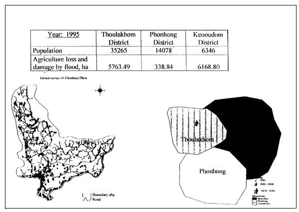
FIGURE 2
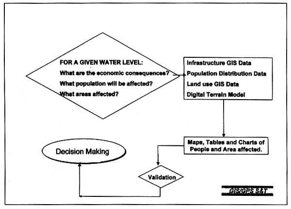
Flood management modelling process
Why select a GIS?
The FMU views the development of the flood management database from a spatial perspective. Using a spatial perspective means that the quantitative and qualitative data, referred to as attribute data in a GIS, is collected and stored together with the associated geographic coordinates. This makes it possible to ask questions about the:
A GIS is designed to link attribute data, for example village name or a specific crop, with spatial data - location or extent as per a geographic coordinate system. The coordinate system can be based on latitude and longitude or a specialized map projection. A GIS is implemented using specialized software that provides a standard or customized Graphical User Interface (GUI), i.e., the buttons and menus on a Windows or Macintosh screen. The GIS GUI enables the user to view a map on a computer monitor, and by moving the cursor and clicking on any map location or feature, the user can call up and view any stored information related to the location or feature.
A GIS analyses data and displays the results. A GIS analysis creates new information by combining or dis-aggregating data. This development of new information can be as simplistic as the calculation of population density by dividing population (an attribute) data by area (spatial data), or as complex as predictive modelling of a village's economic loss by analysing the interaction of:
A GIS is well suited to analysing such complex data sets. For example, the viewer of a two dimensional map that stores and presents only three variables (Figure 1) - rivers, roads, and villages - can easily see and understand the variables' relationships - primarily location with respect to each other. For a spreadsheet to store and handle the same amount of data, let alone present it concisely - that would require an extremely detailed and complex spreadsheet. Even if the data is stored in a conventional relational database, and specific relationships are accessed using a SQL command, the user would not have the simple graphic presentation provided by a map.
As its GIS software, the FMU selected ESRI's Arc View with the Spatial Analyst. It is easy to use, and it can be easily customized with its Visual Basic style language that is included with the software. The Spatial Analyst module enables the user to convert data between raster - graphic - and vector formats. With this the user can create a data surface with peaks and valleys that represent the relative presence and absence of an attribute. The surface is known as a Digital Terrain Model (DTM).
The FMU and FAO selected Microtec GIS/GPS2 to provide the technical consulting and the software training. It is the only entity in the Lao PDR that combines technical skills with local language skills and an extensive database.
GIS/GPS LAO set up the software and hardware system. It provided intensive training in the basic concepts of GIS and in the use of the ArcView software package. GIS/GPS LAO provided three trainers to intensively train three FMU staff. The training was conducted in the Lao language, using English and translated training materials. After the initial training, GIS/GPS LAO worked with the FMU to monitor the development of the digital base maps and the DTMs. Assistance in designing the database also was provided.
The modelling process
The model's objective
The modelling process (Figure 2) is based on the question:
For a given depth of water in the Mekong River what will be the:
The inputs
The variables to answer this question are identified as:
The outputs
The information generated by the model is presented in maps, tables, and charts depicting the economic, social, and physical environments of the flood-affected areas.
Validation and decision making
To ensure that the coefficients and parameters used in the model provide a reasonable simulation of actual events, it is necessary to test the model against historic data. When there is acceptable agreement between the predicted and historic areas, the model is accepted. Once the model is validated, the model can be used for decision making.
DATA PREPARATION
Introduction
The data preparation process (Figure 3) consists of two distinct sets of work. The first set is the field data collected by the FMU. In 1997, the FMU conducted a series of field surveys within the flood prone areas. In addition to collecting socio-economic, demographic, and infrastructure data, the FMU held field interviews to determine and map the extent, depths, and duration of the 1995 and 1996 floods.
FIGURE 3
Data preparation
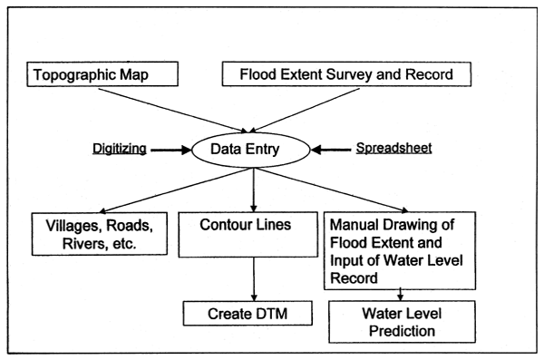
The coordinates of the areas flooded in 1995 and 1996 were measured with a navigation grade Global Positional System (GPS) unit. The large errors associated with navigation grade equipment were acceptable because the initial stages of database development did not require accuracies greater than +/- 50 to 100 metres.
Initially, all field data, including location data, were stored in a spreadsheet. The data on public infrastructure collected by the FMU was supplemented with data from the 1984 series of 1:50 000 topographic maps published by the National Geographic Department, Lao PDR. The data from the maps was entered into the GIS by digitizing. This is the process by which an electronic cursor traces and transmits to a computer a digital representation of the map feature. In addition to infrastructure data, the following map features were digitized:
The digitizing was done using ESRI's PC ArcInfo software. The work was edited and verified by GIS/GPS Lao.
Combining field and map data
The spreadsheet data format and the digital data were combined in ArcView. Each type of data, for example all road data or all river data, were saved as individual themes - data layers - in ArcView. Thus affording the greatest analytical flexibility when analysing the interaction between the numerous themes.
The digitized contour data was processed with the ArcView Spatial Analyst module to create the DTM.
A theme was created of the extent of each historic flood. The associated water level in the rivers also was entered. Initially this data was used to check the predication of different flood scenarios.
FIGURE 4
Infrastructure of Vientiane Plain
Flood mapping
To check the performance of the GIS, an initial series of maps of the Vientiane Plain were produced. These are:
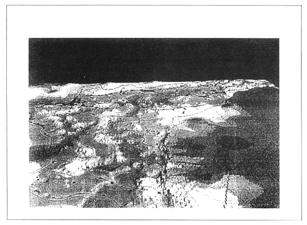
FIGURE 5
3D digital terrain model (The 3-D maps were created from the Spatial Analyst output. To create
and analyse the 3-D output, an ArcView 3-D module must be used.)
These maps are illustrative of the different levels of information a GIS can provide from the same data set. With the GIS analysis, the GIS model can use assumed river water levels to predict the areas that will be flooded, and the model can provide information on the social and economic impact of the flood.
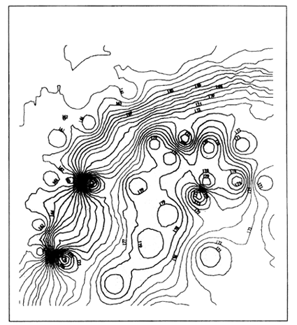
FIGURE 6
Contour line generated from DTM, 1 metre contour interval
Model verification
The data on flood extent and duration collected by the FMU was used to validate the predictive capability of the model. Figure 8 is a 2-D representation of the Vientiane Plain. The areas outlined by a line are those areas flooded in 1996. The solid colour area represents the predication of the model based on the same river height at the main gauging station.
The actual and predicted areas are almost the same. The coarseness of the contour interval (10 metres) input to the model and the use of a navigation grade GPS to measure the location of historic floods can explain the difference.
The flooded area predicted by the model can be seen in different 3-D views, one of which is presented in Figure 9. The views illustrate ArcView's ability to show the same area from different angles and at different resolutions.
FIGURE 7
Flood extent for water level of 169 metres MSL
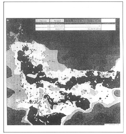
FIGURE 8
Validation of the flood map
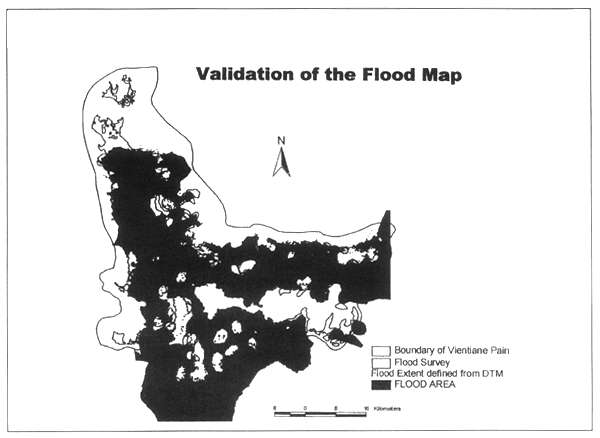
FIGURE 9
Flood area predicted by model
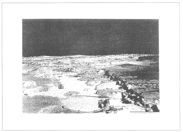
FIGURE 10
Backwater curve model
Remaining work
A great deal of work remains to be done to refine the model. The primary tasks are to:
Collect more attribute data from the flood plains: land use, soil data, geologic data, and village boundaries.
Refine the DTM by surveying the elevations of the flood plains to a greater degree of accuracy. Elevations should be measured to sub-meter accuracy.
Develop a Backwater Curve Model for the Mekong in order to compute for each reach of the river more precise water elevation data (Figure 10).
Create DTMs of the six major flood plains to the south of the Vientiane Plain.
Couple all DTMs with drainage models for each flood plain.
These refinements will enable the FMU to describe more accurately the rate at which floods recede and the duration of critical flood levels. Eventually the national data network will be refined to the point that hydrologists and meteorologists will be able to predict water levels at any point along the Mekong on the basis of upstream levels and on incoming storm patterns.
Summary
In summary, the FMU, FAO, and the farmers are working together to produce a practical national flood management plan. Given the complexity of the data required for the plan and the complex analysis required to estimate flood impact, the FMU selected Arc View GIS as the most user friendly software that will handle the complex data while presenting it in a easily understood format.
To simulate flooded areas and the impact of floods it is necessary to collect and process more detailed data.
Introduction
Flooding in many areas across Laos and indeed the whole of the Mekong River Basin is a common feature associated with cyclonic conditions emanating from the prevailing monsoon. Lao People's Democratic Republic has experienced 22 floods of different magnitudes and durations since 1966 and two of these occurred in the last two consecutive years, 1994 and 1995. Of the 22 floods, four were large and disastrous. This flood pattern indicates that, on average, a flood occurs in Laos every 1.4 years and a disastrous flood every 7.5 years. The 1994 flooding from the Mekong River and its tributaries damaged about 28 000 ha of cropped land, but the flood which occurred during August-September 1995 was the worst since 1966 and can be regarded as a major disaster for the agricultural sector in the Vientiane Prefecture and the provinces of Vientiane, Bolikhamxai, Khammouane, Savannakhet and Champassak. According to Government of Laos (GOL) estimates, up to 87 300 ha were inundated and up to 62 000 ha of paddy crops were totally destroyed. Considerable damage was caused to irrigation and other infrastructure, as well as to about 260 ha of fishponds.
In the Lao PDR, the floods of 1995 and 1996 in particular significantly affected the main central low lying rice producing areas, in those areas which are immediately adjacent to the Mekong river and its tributaries. These areas are located within the provinces of Vientiane, Borikhamsay, Khammouane, Savannakhet and Champassak. The areas have been broadly defined as lying within the following geographical areas:
Area 1 21 N, 101 E - 19 N, 103 E
Area 2 19 N, 101 E - 18 N, 104 E
Area 3 18 N, 104 E - 16 N, 106 E
Area 4 16 N, 105 E - 14 N, 106 E
In the Mekong Basin records indicate that the primary causes of floods are related to the heavy incidence of rainfall exacerbated by other local factors. Although both major and minor floods have occurred during all seasons, the majority of the documented events have taken place during the period between September and December, where the potential for coincidence of primary causes is highest. Direct economic impact of flooding is in many cases substantial. The damages directly attributable to flooding are very considerable and average several millions $ per year. A very accurate delineation of the flooding extent at any given time would prove invaluable for estimating flood damages and in adequately managing flood damage compensation.
John Latham, Research, Extension and Training Division,
FAO, Rome, Italy
The available data on areas affected by the 1995 flood were until recently, both sketchy and inadequate and they had not been gathered in a scientific manner. Also, the damages caused to human life, livestock, agriculture and infrastructure needed to be determined more accurately both in terms of quantity and cost from detailed field surveys of affected areas.
The subsequent survey of 1995/96 flood affected areas in the Vientiane Province and Prefecture, where the flood damage was most severe, not only filled an important gap in our knowledge of flood behaviour and damage but also started to provided the data necessary for designing the necessary structural and non-structural measures for flood loss prevention which might then be presented to funding agencies and bilateral donors as a capital investment project. The work involved the analysis and mapping of the extent of flood inundated areas through the integral use of the use of historical topographic maps and historical aerial photography coupled with field data collection methods. In order to provide a more operational capacity to monitor the regular and seasonal changes which occur in the flood plains of the Mekong, it is advocated that alternatives, which include the utilization of remotely sensed data, in particular microwave data from the Radarsat satellite, be properly programmed and budgeted into the activities for forthcoming flood seasons.
Rationale for the incorporation of a remote sensing component in flood monitoring systems.
Frequent flooding from the Mekong River and its tributaries affects almost the whole country, and especially the low-lying areas along the river banks. It is nearly two years since the last major flood in 1996 occurred but the available data on this disastrous flood was scarce until recently in quantity and lacking in details. In order to propose any short and long term measures to prevent losses from flooding, it is essential to have reliable data on areas flooded, duration and depth of flooding and the damages caused and their estimated repair or rehabilitation costs available to decision makers in as short a time as possible. Such data will also be a prerequisite for developing a national strategy and action plan for flood loss prevention and flood management. Without such a national strategy on flood management, a sustainable water resources or agricultural development will also not be feasible. Few possibilities exist to meet these demands.
Flood boundaries are often difficult and expensive to map during a flood event. Aerial photography is adversely affected by cloud, cannot be flown in storms, and cannot always clearly differentiate muddy banks from silty water. Furthermore, the most common 9 × 9 inch formats cannot be easily integrated with quantitative map data. Satellite remote sensing by optical means is usually ineffective for progressive monitoring because of cloud cover problems. Until the advent of RADARSAT, synthetic aperture radar satellites have suffered from poor revisit performance and sometimes ill-matched radar parameters. The use of extended high beams for flood monitoring, pioneered in this work, reduces the average revisit interval to less than 2 days when used in combination with standard beams.
RADARSAT data combined with appropriate analysis to extract the flood boundary is a cost-effective means of determining geographic extent of a flood event over time. Historically, as has been discussed - the delineation of flooded areas was accomplished by ground observations. These observations rarely represent complete coverage and are costly and time consuming. With the advent of aerial and satellite imaging systems, the monitoring of flooding events can be obtained faster and more accurately over a larger area than with previous methods. Remote sensing is also very useful for monitoring the effects of man-made changes to the watershed, such as road and rail construction, flood-way construction, field drainage, channel alterations, land treatment measures, construction of dikes, levees, and flood walls, as well as any natural changes that offset the flooding patterns.
Among the possible sensors for flood monitoring, active microwave systems, such as imaging radars, have several characteristics that make them appealing to the water resources manager. Among them, the longer wavelengths at which microwave systems operate provide the ability to penetrate clouds and most other atmospheric phenomena. Thus, by using an active microwave system, it becomes technically feasible to obtain imagery during the flood peak days, which are often associated with cloud cover. Another advantage inherent to microwave sensors is the possibility to penetrate partially through the vegetation cover, especially at the longer wavelengths.
The characteristics of a radar image depends strongly on earth features, such as topography, small scale roughness (in the centimetre range) land cover (presence of vegetation), and the moisture content of the target, as well as system parameters, such as frequency, polarization, and viewing geometry. A few studies have demonstrated so far interesting possibilities of imaging radars for flood monitoring and mapping.
The future of earth observation monitoring from space sensors seems assured the current schedule of launches and capacities from a variety of national sources is prolific by comparison with recent years data availability. Table 1 shows the wealth of future capacities for earth observation monitoring. However, few satellite capacities can be operationally considered in environments which include a high incidence of cloud and persistent rains, making conventional optical imaging less than timely or useful.
RADARSAT is perhaps currently the most operational sensor of its kind and can be used to provide all-weather, day/night monitoring of synoptic flood extent at intervals averaging less than 2 days, and can be analysed to provide GIS-ready vectors with estimated accuracy better than 100 m. This information complements established sources such as field reports, airphoto and airborne videography which are vital for damage assessment.
In this paper the emphasis is on practical issues and demonstration of operational potential for flood monitoring using RADARSAT.
RADARSAT and flood monitoring
RADARSAT is a nearly ideal sensor for flood extent monitoring by virtue of its all-weather imaging capability, relatively frequent revisit, and excellent ability to distinguish open water and flooded vegetation from land classes with good accuracy in temperate zone vegetation. These benefits derive from RADARSAT's wide field of view, the relatively long wavelength of the C-band radar, horizontal transmit and receive polarization of the signal and the large range of incidence angles available for imaging. Unlike optical imagery, interpretation of radar images requires understanding of the physical and dielectric properties of the surface. Some types of ground cover can be easily mis-classified as flooded, and geometric distortions peculiar to radar require special handling.
TABLE 1
Land imaging satellite systems in the next five years
| SATELLITE FUNDER | SATELLITE | INSTRUMENT(S) | LAUNCH | SENSOR TYPES | RESOLUTION IN METERS | STEREO Type | SW KM | GLOBAL COVER REPEAT days | |||||||||
|---|---|---|---|---|---|---|---|---|---|---|---|---|---|---|---|---|---|
| THEMATIC MAPPER BANDS | |||||||||||||||||
| PAN | VNIR | SWIR | MWIR | TIR | R/L | ||||||||||||
| 1 | 2 | 3 | 4 | 5 | 7 | 6 | res,band | ||||||||||
| LANDSAT LIKE, FREQUENT GLOBAL COVERAGE | |||||||||||||||||
| INDIA (Gov.) | IRS-1 C,D | PAN, LISS-3, (WIFS) | '95,'97 | M&P | 6 | 23 | 23 | 23 | 70 | C/T | 70 142 | 48,24 | |||||
| INDIA (Gov) | IRS-P6 | LISS 4, (AWIFS) | '01 | M | 6 | 6,80 | 6,80 | 80 | C/T | 24 700 | 125,4 | ||||||
| FRANCE (Gov) | Spot 4 | HRVIR, (VEGETATION | '97 | M&P | 10 | 20 | 20 | 20 | 20 | C/T | 120* | 26 | |||||
| CHINA-BRAZIL (Gov) | CBERS | CCD, IRMSS, (WFI) | '98,'99 | M&P | 20,80 | 20 | 20 | 20 | 20 | 80 | 80 | 160 | C/T | 120 | 26 | ||
| U.S. (Gov) | Landsat 7 | ETM+ | '98 | M&P | 15 | 30 | 30 | 30 | 30 | 30 | 30 | 60 | 185 | 16 | |||
| U.S./JAPAN (Gov) | EOS AM-1 | ASTER, (MODIS) | '98 | M | 15 | 15 | 15 | 30 | 5 @ 30 | 5@90 | F/A | 60 | 49 | ||||
| R21, A, B, C, D | Resource 21 | M10 | 4 by 2/01 | M | 10 | 10 | 10 | 10 | 20 | 200* | 4** | ||||||
| Matra Marconi Space | XSTAR | 2 by 01/02 | M | >10 bands @ 20 | 320 | 4*** | |||||||||||
| HIGH RESOLUTION, SMALL AREA COVERAGE | |||||||||||||||||
| EarthWatch | EarlyBird 1,2 | '97,'98 | M&P | 3 | 15 | 15 | 15 | 3 @ 20 | 2 @ 20 | 3@20 | F/A | 36 | 120 | ||||
| Spacelmaging EOSAT | IKONOS 1,2 | '98,'98 | M&P | 1 | 4 | 4 | 4 | 4 | F/A | 12 | 247 | ||||||
| U.S. (NASA) | Clark | '98 | M&P | 3 | 15 | 15 | 15 | F/A | 36 | 120 | |||||||
| EarthWatch | QuickBird 1,2 | '99,'00 | M&P | 1 | 4 | 4 | 4 | 4 | F/A | 20 | 148 | ||||||
| U.S. (DoE) | TBD | MTI | '98 | M | 4 @ 5 & 3 @ 20 | 13 | 228 | ||||||||||
| Orbimage | OrbView-3,4 | '99,'00 | M&P | 1&2 | 8 | 8 | 8 | 8 | F/A | 4&8 | 740 370 | ||||||
| West Ind. Space | Eros-B2, 3, 4, 5, 6 | '01–'02 | P | 1 | 4 | 4 | 4 | 4 | F/A | 13 | 30*** | ||||||
| RUSSIA (Gov) | SPIN-2 | KVR-1000, TK-350 | '98 | P(f) | 2,10 | F/A | 180 200 | ||||||||||
| West Ind. Space | Eros-A | '98 | P | 1,5 | F/A | 13 | 228 | ||||||||||
| West Ind. Space | Eros-B1 | '99 | P | 1 | F/A | 13 | 228 | ||||||||||
| INDIA (Gov) | IRS-P5 | PAN | '99 | P | 2,5 | F/A | 30 | 99 | |||||||||
| HYPERSPECTRAL | |||||||||||||||||
| Orbimage (U.S. AF sensor | OrbView-4 | Warfighter | '00 | H | 200 bands @ 8 | 80 @ 8 | 5 | 600 | |||||||||
| U.S. (NASA) | EO-1 | '99 | H&M | 128 bands @ 30 | 256 bands @ 30 | 15 | 200 | ||||||||||
| U.S. (NAVY) | HRST | '00 | H | 5 | 210 bands @ 30 | 30 | 100 | ||||||||||
| AUSTRALIA | ARIES | '00 | H | 10 | 32 bands @ 30 | 32 @ 30 | 15 | 200 | |||||||||
| ACTIVE (RADAR/LIDAR) | |||||||||||||||||
| CANADA (Gov) | Radarsat | SAR | '95 | R | 10–100 C | 50–500 | |||||||||||
| ESA (Gov) | ERS-2, ENVISAT | SAR, ASAR | '95, '99 | R | 10,30 C | 100 | |||||||||||
| U.S. (NASA) | VCL | MBLA | '00 | L | 25 | 8 | |||||||||||
| U.S. (NASA) | LiteSAR | '01? | R | TBD | TBD | ||||||||||||
| Multispectral | M | All satellites in polar sun synchronous orbits except SPIN-2 (65 Deg) & QuickBird (> 52 Deg) | (XXX) = Wide swath, lower resolution insts. | ||||||||||||||
| Hyperspectral | H | F/A = fore/aft stereo, C/T = side to side stereo. | Inst. | # bds | Res meters | Swath kilometers | |||||||||||
| Panchromatic | P | All stereo satellites have 2 to 3 day site repeat capabilities | WIFS | 3 | 188 | 810 | |||||||||||
| Radar/Lidar | R/L | * = Swath is achieved by two side by side instruments | Veg. | 4 | 1000 | 2200 | |||||||||||
| Film | (f) | ** = 4 satellites are planned to provide 3.5 to 4 day global repeat coverage. | WFI | 2 | 260 | 900 | |||||||||||
| VNIR | Visible and near IR | *** = 7 satellites are plannedWhere there are two values, they are in the order of the listed sensors | MODIS | 2 5 29 | 250 500 1000 | 2330 2330 2330 | |||||||||||
| SWIR | Short wave IR | ||||||||||||||||
| MIR | Mid-wave IR | ||||||||||||||||
| TIR | Thermal IR | ||||||||||||||||
NES 99-02-02
Mitretek
Processing and analysis
Five major steps are required to extract the flood boundary in an operationally usable form:
formatting as digital map data for compact electronic transmission and GIS integration.
Operational relevance
Knowledge of the geographic outline of the flood is important for a number of activities:
Conclusions and recommendations
RADARSAT in combination with appropriate processing and analysis can provide synoptic all-weather flood extent data at regular intervals with estimated accuracies of better than 100 metres. The following elements are important for successful flood monitoring using RADARSAT:
A highly automated, operational service bringing these elements together should be established to support operational flood management activities worldwide. Finally, the GIS vectors generated during this study should be compared with independent sources of flood extent information for validation purposes.
Introduction
The Mekong River is the longest river in Southeast Asia and one of the largest rivers in the world. In terms of drainage area it ranks 21st and in terms of length (more than 4 200 km) it ranks eighth. Originating on the Tibetan plateau at an elevation of more than 5 000 m, the Mekong River flows south through the Peoples' Republic of China, Myanmar, Lao, Thailand, Cambodia and Viet Nam to the South China Sea. The Mekong River drains an area of 795 000 km2 of which about 606 000km2 is in the Lower Mekong Basin, embracing almost all of Cambodia and Lao, one third of Thailand (its north-eastern region and part of the northern and eastern regions) and one fifth of Viet Nam (the Central Highlands, the Mekong Delta and parts of the central and northern regions).
The flow of the Mekong River derives largely from rainfall and its discharge in turn reflects the pattern of rainfall distribution during the year. The Upper Mekong Basin, which constitutes 24% of the total basin area, contributes only 18% of annual runoff. Each year, about 475 000 MCM of water empties into the sea. At Pakse, Laos, where the discharge accounts for 69% of the total area, the maximum discharge (57 800 m3/s) is 50 times more than the minimum discharge (1060 m3/s).
In the Lower Mekong Basin agriculture is a primary activity. Rice is the major crop, but due to poor soil, poor water management or shortages of fertilizers, yields are generally still low. Moreover, frequent flooding from the Mekong River and its main tributaries affects especially the low-lying rice-growing areas along the river banks. Reliable data on areas flooded, duration and depth of flooding, needed to propose flood management measures and planning for a sustainable agricultural development, are lacking. An updated and comprehensive land resources inventory is required for agricultural development and planning of the riparian countries and the Mekong River Commission (MRC). In view of this, the MRC is initiating the development of a land resources information system for agricultural development and planning under the Land Resources Inventory for Agricultural Development (LRIAD) Project.
One important component of the LRIAD project is the development of an inundation spatial database of the main flood-prone areas. The inundation layer data will form part of the land resources information. The data will be useful for designing necessary measures for flood loss prevention to be used for sustainable agricultural planning and management. The land resources information will be developed over the following years using remote sensing and GIS tools. Combined with conventional methods, this will supplement the existing Mekong GIS. This data, in return, will serve the needs of the analysis of data pertaining to land characteristics in order to aid the management or planning of land uses.
Nokeo Ratanavong, Officer-in-Charge, Technical Support Unit
Mekong River Commission Secretariat, Bangkok, Thailand
FIGURE 1
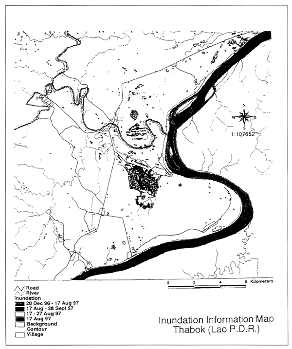
Location of Thabok study area
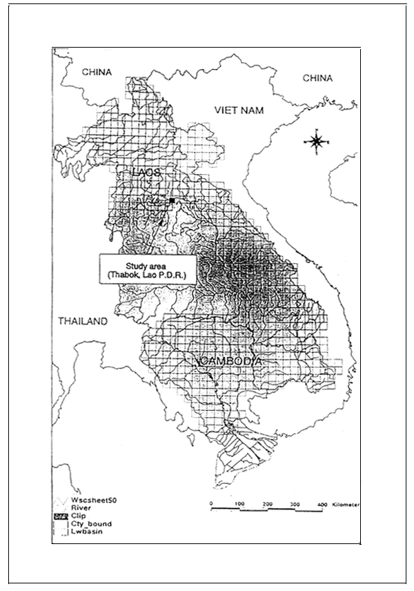
As part of the effort to develop the information system, the MRC Secretariat is conducting a joint study with the Japanese Institute for Irrigation and Drainage (JIID) on inundation mapping using remote sensing technology. The inundation mapping will focus on the main low-lying areas along the Mekong River and its main tributaries. In the initial year, the study is being done in a pilot area located at Thabok in the Lao PDR. (See Figure 1).
This paper attempts to provide an introduction on the methodology for developing inundation data layer to supplement the Mekong GIS. The inundation data of the pilot study area in Thabok, Lao PDR, are extracted using RADARSAT imageries and processed with GIS data layers. The processing of the inundation data with the GIS data layers and its results are discussed here.
The mekong GIS
It has always been essential for the MRC to obtain relevant current information on the environment and natural resources of the Lower Mekong Basin. The MRC Secretariat currently maintains a Geographic Information System with basin wide data layers, i.e. land use, geology, drainage, watersheds, etc., mainly at a 1:250 000 scale. The main activity in the development phase was assembling, organizing and undertaking an inventory of features of interest at the scale of 1:250 000 and digitizing these using standardized input operations to develop consistent and compatible products. At the MRCS and riparian counterpart agencies, PC ARC/INFO GIS software was selected for data input. 1:250 000 scale topographic map sheets (UTM) prepared by the USAMS covering the entire Lower Mekong Basin were selected as the common base map for preparation of thematic digital maps.
Remote sensing technology (aerial photography and satellite imagery) was used by the MRCS to compile the required data. The joint application of remote sensing and GIS proved to be useful to identify changes. Remote sensing is a tool for detecting change, GIS the tool for quantifying the process of change. The basis of change detection is the comparison of remote sensing data and map data, or the comparison of remote sensing data taken at two or more different times. When working with multi-temporal data sets, geometric registration is a fundamental concern. This applies to inundation mapping as well.
Although many maps were digitized, some gaps still remain within certain areas and/or layers. These gaps need to be filled by collecting/generating new data and digitizing these in order to have complete layers of baseline data covering the Lower Mekong Basin. Inundation data layer is one category of information now required. Efforts are now being made with JIID assistance to develop a methodology using remote sensing technology to collect inundation data.
Objectives and scope of inundation mapping
The development objective is to monitor flooded areas in the Lower Mekong Basin, providing inundation data layer for input and use in the land resources information system. The inundation mapping will focus on the main low-lying areas along the Mekong River and its main tributaries. Data on these flood-prone areas will fill an important gap in the knowledge of flood extent and damage, and is necessary for designing the necessary measures for flood loss prevention and for planning sustainable agricultural. To ensure that the inundation data can be efficiently used, the inundation map product must be at the same scale and format used for Mekong GIS data sets (in ARC/INFO format at 1:250 000 scale and using the USAMS base map with UTM projection).
The scope of the joint study in the first phase is to design an adequate remote sensing methodology, including SAR, for extracting data for inundation mapping. A pilot study is being conducted in selected flooded areas along the northern stretch of the Mekong and its main tributaries, with the Thabok area being selected. The pilot study will provide methodology that can be applied for similar mapping in other parts of the Mekong River Basin.
Inundation mapping is being carried out by the Technical Support Unit of the MRCS in cooperation with the JIID. JIID assists in developing a remote sensing methodology to process radar imageries to be used by the MRCS in inundation mapping and monitoring activities. The results of the study, if successful, can be then applied for similar mapping in the lower parts of the Mekong River Basin in the following years.
Inundation mapping
Remote sensor for inundation mapping
The near-infrared band of optical sensor is effective for inundation water bodies. The nearinfrared radiation is absorbed at the pure water surface. Water bodies (flooded areas) are shown dark in images with near-infrared band. Optical sensors can detect not only the existence of water bodies, but also water characteristics according to colour. This is an advantage of the optical sensor. Its main disadvantage is that it cannot penetrate cloud cover. Hence, when the weather is cloudy, the sensor cannot observe the ground surface phenomena. Floods usually occur in the rainy season. Although images from optical sensors are collected continuously as it revolves, it is not so easy to obtain cloud free image from optical sensors (or with little cloud) to observe the flood phenomena.
SAR (Synthetic Aperture Radar) is one of the optimum sensors to observe flood phenomena and inundation area. Water surface is easy to identify by its radar characteristics, even during rainy or cloudy days. A SAR image is the ratio of microwave energy transmitted to the earth to the energy that is reflected directly back to the sensor. The energy returning to the sensor is called backscatter. The backscatter of an imaged area is dependent of the topography, centimetre-scale roughness, and dielectric properties, which are directly affected by moisture levels. Low backscatter values are portrayed dark image tones or black, while high backscatter values are shown as light image tones or white. The inundated area is covered by water at its surface. The water surface is like a mirror plane with the characteristics of particular reflection that has less backscatter.
Nowadays, RADARSAT is the most effective satellite for inundation mapping, with flexible observation timing and pointing functions. RADARSAT is equipped with seven beam modes, which offer image resolutions ranging from 8 to 100 metres. RADARSAT is designed in such a way that its beam can be steered at incidence angles ranging from 10–60 degrees. It offers special coverage ranging 50–500 km swaths, and can be used for mapping at the sales of 1:1 000 000 to 1:50 000. RADARSAT's scanSAR narrow beam mode offers 50-metre resolution and 300 km2 coverage, which supports the identification of structural trends and features. The standard beam mode with 25-metre resolution is for general purpose. The fine beam mode with 8-metre resolution is for special use in limited area.
However, RADARSAT does not collect data continuously and does so only upon order. In this inundation mapping study, JIID and MRCS selected RADARSAT-SAR as the main sensor for extracting inundation data.
Outline of SAR image processing
The processing of the SAR for inundation mapping is as follows:
Geometric correction
Most important in the processing of SAR data for inundation mapping is geometric correction, extraction of inundated area and speckle noise reduction.
Geometric correction is necessary to overlay the time series inundation images of SAR, i.e. the inundation peak period data, its receding period data, the low flood period data and the dry season data. But SAR data has many of distortions such as layover and foreshortening mainly caused by topographic conditions. These distortions are not easy to correct. But geometric correction is indispensable if we wish to overlay multi-temporal image data.
RADARSAT SAR images has just only one band and data are represented by grey levels in the image. The extraction of inundated area means the selection of sampling of permanent water area value and its surrounding area. But SAR image has a lot of speckle noise (small dot point with its spatial characteristics). The selection of threshold must take into consideration the speckle noise factor. The speckle noise can however be effectively removed by some spatial filter operations.
Overlaying inundation data with GIS
The processed RADARSAT satellite image is printed at a scale of 1:50 000. The boundaries of the inundated areas at different time periods were fair-drawn and digitized into vector ARC/INFO format for later overlay with other data layers (see Figure 2).
The topographic data are extracted from topographic maps at a scale of 1:50 000 (UTM system), including rivers, elevation contours, villages and roads. The digital GIS topographic layers are digitized into vector ARC/INFO format.
Mismatch data between layers were initially anticipated since image and topographic data were obtained from two different sources. To reduce this error, additional ground control points were extracted from the 1:50 000 hard copy topographic maps and used to transform the inundation coverage. Errors were still noticeable but acceptable. The main reason for data mismatch was due to data being extracted from two sources, RADARSAT images and the 1:50 000 hard copy maps. With common reference points the data can be better overlaid and used for field verification.
FIGURE 2
Overlay of inundation data on GIS data layers
Concluding remarks
From the experience of the MRC, standard base maps and standard procedures for collecting data are found as a basis if one needs to aggregate data from different sources on a basinwide or regional level, especially for handling and processing data across country borders. If not, considerable effort must be made to pre-process the data for input into the GIS.
Pre-processing are procedures used to convert a data set into a form suitable for permanent storage with GIS database. The end result of processing phase is a coordinated set of thematic layers. For basinwide data layers, standards in mapping should be maintained throughout the region with common map projection for all data layers and common classification for each of the data layers. However, base maps available in the region are of different map projection and datum. Maps and images of the region must be processed before use in a GIS due to the fact that they are produced from different maps with different projection and/or images with certain geometric distortions. For thematic maps, the classification may differ also. Much data entered into GIS requires some kind of processing and manipulation in order to make it conform to a data type, georeferencing system and data structures compatible with the system. If the mapping activities are uncoordinated, the result will be a mixture of incompatible data generated by different GIS software and/or using various map standards. Standards should be established before developing basinwide data. This requires an agreement on the type, content and structure of the data.
In the context of Mekong projects, standards are referred as practical working guidelines which permit a uniform databases building covering the part of the Lower Mekong Basin in the four riparian member countries. Practical working guidelines, e.g. standardized input and standardized operations on that input, forms a basis for developing a consistent and uniform product. They would facilitate comparability of data, information exchange and/or the aggregating of the basin-wide data layers for the specific type of data set to be developed.
Another problem when acquiring any data set is that of data quality. Variations in time, spatial coverage, density and measurement method may be hidden imprecise definitions and in consistent use of terminology. There are problems of accuracy in position and attribute, especially if data comes from various sources and scales. The problem of user is to decide whether non-coinciding boundaries are real or whether they are simply a reflection of variations in data quality. To answer this, the user requires specialist knowledge of the data sets, including the history of their derivation. Misunderstanding how and for what purpose the data was originally generated may lead to the misinterpretation of data. Resultant analysis could in this way lead to the establishment of inappropriate policies.
In the pilot inundation mapping study, the extent of the flooded areas and the duration of the inundation (between images acquired on two consecutive days) can be analysed. It should, however, be noted that the extent of the inundation is true on the date of acquisition of the respective satellite image, and the duration of inundation is true between two or several dates of acquisition of satellite images.
The main problem is inundation mapping is that one cannot predict well in advance when an area will be flooded and when the highest peak of the flooding (meaning the greatest extent of the inundation) will occur. Some areas in the Lower Mekong Basin are inundated for less than two weeks, making necessary the prompt scheduling of SAR data acquisition and processing.
Pilot project description
The 1997 Flood Vulnerability Mapping Pilot Project is a joint project between Aruna Technology Ltd. (Aruna), RADARSAT International (RSI), and the World Food Programme (WFP). The goal of the project is to investigate the technical and financial feasibility of using RADARSAT data to assess water damage to rice crops by comparing imagery taken before, during and after flooding of cultivated areas.
The pilot project was divided into two distinct phases: Phase I - Flood Vulnerability Mapping and Phase II - Rice Crop Monitoring. This progress report outlines the activities undertaken during Phase I of the pilot project. Phase I will provide a reasonable estimate of the areas damaged by flooding and is sufficient to fulfil the original terms of reference for the pilot project. Phase II will enable further refinement and improvement of the results of Phase I by increasing the understanding of the agricultural land use and patterns in the areas. The necessary information for Phase II is being acquired during this initial phase. However Phase II will only proceed when sufficient funding has been acquired.
In Phase I, the RADARSAT imagery will be used as a backdrop to map inundated areas at four different Mekong River stages. Geographical Information System (GIS) software will be used to digitize vectors over areas recognizable as inundated from the imagery. Additional existing GIS vector data-sets will be overlaid to provide information on land use and administrative boundaries among others. This will provide the basic data necessary for evaluating which areas are vulnerable to flooding and estimating an approximate area of rice paddy which was flooded during 1997 for each commune of interest to WFP. The map created during this exercise will demonstrate the utility of RADARSAT imagery for creating a basic flood inundation map. This information is considered important and useful for the work of many different agencies. Additional imagery taken at different river stages and processed according to the methodology developed in this pilot project can provide the remainder of the data to produce a complete and detailed flood inundation map.
In Phase II, the data from many different agricultural field trials will be compared with the RADARSAT imagery to examine if there are recognizable patterns from rice growing (and other cropping) that can be seen using multi-temporal images. Patterns thus identified will then be applied as filters and compared to sealed field trial results to examine whether they are accurate. In addition, the results will compared to existing land use maps, aerial photographs and other secondary data to see if they provide a broad indicator of agricultural practices.
Jeffrey Himel, Aruna Technology Ltd., Phnom Penh, Cambodia
If patterns of reasonable accuracy are identified, these will be used over wider areas to extrapolate the total areas cropped and to evaluate the expected cropping patterns as revealed by the satellite imagery. This data would thus provide an improved understanding of agricultural land use in the area. It is hoped that the total areas cropped will be able to be identified as well as possible indicators of yield. Should the Phase II pilot work be successful, it would thus provide improved accuracy for estimation of cropped areas and their potential yields or losses. By applying this data to the areas known to be inundated from Phase I, an improved understanding of the losses due to flooding would be obtained.
While the data necessary for Phase II to be undertaken is being collected and collated, additional funding will be necessary for the processing and analysis work to take place. Possible sources are being contacted and any additional support would be helpful.
Project activities
Most of the work to date has consisted of arranging for, collecting and preparing data. All of the RADARSAT imagery has been acquired. All of the eight images are in Phnom Penh at Aruna Technology; copies have been made and are kept at WEP and RSI. Images were taken in August, October, December and January and all were successful (see Appendix A for examples). Over 150 aerial photographs have been scanned and processed along with their corresponding map locations. Access to existing GIS and hard copy data-sets has been arranged. Much of the work has centred on coordinating ground truthing and the preparation, collection and checking of this data (see Appendix B for examples).
Cooperating agencies
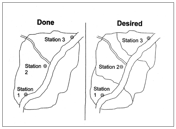
Ground truthing data from the field has been collected by several agencies whose staff are cooperating in the project. The areas where ground truthing is being performed are indicated in the following map. These agencies include:
In addition, the Cambodian National Mekong Committee (CNMC) has co-operated by providing aerial photography of the many spot and field locations. The Geographic Department of the Council of Ministers will work with Aruna Technology to geo-register, process and analyse the imagery as well as digitize vector layers outlining flood levels. The GDIMH will assist in coding surface water features.
Discussions have been held with other agencies that are expected to provide additional data from their field work and project files. Note that the map of the on-going ground truthing work doesn't show the many locations where WFP staff is taking spot location readings.
Description of ground truthing activities
Agency staff provide GPS readings and descriptions of their project field plots, landmarks or spot locations to Aruna Technology. Aruna staff mark the locations on the relevant 1:50 000 US Defense Mapping Agency topographic maps and acquire the aerial photography from the CNMC. The maps and photos are scanned and processed then written to CD-ROM. The aerial photographs and map scans are then arranged in a graphic and printed for field staff by Aruna to enable them to precisely locate points of interest. Field staff mark the locations and provide trial results, descriptions, photographs and additional data from project reports. See Appendix B for a summary of the ground truthing activities for each of the co-operating agencies (again, WFP has additional information that is not included). Secondary data has been gathered in the form of other project reports, previous flood inundation and topographic maps and current GIS data sets.
The ground truthing data is needed for the image processing and analysis. It is important that the information collected is accurate and can be precisely and correctly located. The quality of the analysis improves with more data. Data from 68 different field crop trials will be collected and used for analysis and to evaluate the results. Numerous identified landmarks and spot locations have been or are in the process of being collected.
Acquisition and installation of software and hardware
Both the image processing software and GIS software have been installed and tested successfully at the Geographic Department as well as at Aruna Technology. Observation of the imagery confirms RADARSAT's advantages in identifying inundated areas.
Next steps
Ground truthing from WFP, Aruna and the aforementioned cooperating agencies will continue until the remaining data preparation and checking work is completed. Additional information such as cropping calendars and village maps will be acquired or estimated.
Image processing and analysis
The following steps will be taken in image processing and analysis:
PHASE I: FLOOD VULNERABILITY MAPPING
Acquired images are corrected and registered to the UTM-48 projection.
The known conditions on the ground are matched and compared with the radar signatures for that location in a process known as characterization. This enables identification of distinctive features.
Distinctive features are used for correcting and registering the RADARSAT image to the topographic map projections used in Cambodia for maps and GIS datasets. This enables the use of existing datasets for analysing the satellite image.
Existing GIS datasets in Cambodia (Geographic Department) are layered over the RADARSAT image.
The vector data makes it much easier to understand the radar image and what features you are looking at. The vector data can be used as a boundary within which areas can be calculated and specific analysis can be performed.
Images taken during the highest river stage are used to identify inundated areas; GIS vectors are digitized over top to provide the boundaries of flooded areas for that river stage.
This process is eventually repeated for all the images in order to form the first layers of an accurate flooded area map for different river stages.
Commune boundaries are used to calculate the percentage of land flooded within during the highest river stage within each Commune.
This forms the first indicator of vulnerability to flooding. This process is eventually repeated for all the images. GIS vectors will be drawn around the inundated areas to delimit them. This will be linked to the gauge height at the hydrological stations along the Mekong from Stung Treng to Neak Luong in Prey Veng. Comparison of the inundation vectors with the land use in the area and the river stage would indicate whether there may have been problems at different points in the growing season. The changes in areas in undated at different river stages will provide a clear picture of micro-elevation in the floodplain areas.
The images are merged and processed so that changes over time in each location can be more clearly observed. This is printed as hard copy and a report is prepared detailing the results of the project for flood mapping.
Typically, the images are processed into different “false” colours (such as one red, one green and one blue) and combined so that the changes or similarities in colour can be seen clearly. Statistical analysis and the distribution of signatures can also be used to analyse the patterns of the merged imagery. Different filters including “despeckling” assist in making the data easier to understand.
At this point, the basic objectives of the pilot project will have been fulfilled. The project moves into the second pilot phase, investigation of RADARSAT imagery for rice crop monitoring.
PHASE II: RICE CROP MONITORING
Patterns from field trials are examined to identify if there are recognizable patterns that can be seen from the imagery. The identified patterns for rice cropping are then applied as a filter to the merged image to estimate cropped areas.
This provides an estimate of overall cropped areas. Some of the field trial results will be kept sealed so that they may be compared with the estimated cropping pattern to determine an indicative accuracy of the method.
A hard copy of the output is printed and a report is prepared outlining the findings of the project and conclusions regarding the efficiency and accuracy of using RADARSAT imagery for flood mapping and crop assessment.
TABLE 1
Schedule of activities. Flood vulnerability mapping and rice crop monitoring
| Activity | Expected schedule | |
| 1a | Kratie images corrected and geo-registered | 1–15 March |
| 2a | Existing GIS assets overlaid on Kratie images | 8–15 March |
| 1b | Prey Veng images corrected and geo-registered | 16–31 March |
| 2b | Existing GIS datasets overlaid on Prey Veng images | 25–31 March |
| 3a | Digitization of maximum flooded areas, Kratie images | 15 March-3 April |
| 3b | Digitization of maximum flooded areas, Prey Veng image | 1–22 April |
| 4a | Estimation of flooded areas in communes | 3–30 April |
| 3c | Digitization of flooded areas, remaining images | 22 April-31 May |
| 4b | Estimation of cropped areas at risk to flooding | 1–15 May |
| 4c | Final report preparation, flood vulnerability assessmen | 15–31 May |
| 5 | Images merged, hardcopy printed Pilot Phase II Rice Crop Monitoring | 15–31 May |
| 6 | Analysis of field trials, pattern identification, filtering and processing for rice crop monitoring | 1 June-15 July |
| 7 | Hardcopy output prepared, printed and distributed, final report for rice crop monitoring | 15–31 July |
Bibliography
Boeung Phtea Topography and General Direction of Flood Flow, JICA Floodplain Study, 1:60 000 scale, hard-copy.
CIAP-IRRI Cambodia Digital Datasets, ARC/INFO Format.
FAO, 1996. Report of the FAO/WFP Crop and Food Supply Assessment Mission to Cambodia.
FAO, 1997. Evaluation of the Impact of Flooding on the Agricultural Sector in Cambodia.
FAO, 1997. Special Report: FAO/WFP Crop and Food Supply Assessment Mission to Cambodia.
Flood Inundation Map. Vietnamese Government Study (mid-1980's), 1:250 000 scale, hardcopy
Geographic Department of Cambodia Digital Datasets, ARC/INFO Format.
JICA, 1997. Flood Inundation Map. Floodplain Study, 1:500 000 scale, hard copy.
Manitese, 1994. Srey Ampil Irrigation System, Srok Kien Svay, System Layout and Individual Field Ownership.
Mekong River Floods in Kompong Cham Province. 1996, PRASAC-I
Sanyu Consultants, 1997. Agricultural Development Study of the Mekong Flooded Area in Cambodia, Interim Report.
Takeuchi, K. and Chomchalow, N. 1991. Cambodia August 1991 Flood Assessment Report, FAO.
UN-ESCAP, 1988. Proceedings of the Expert Group Meeting on Improvement of Flood Loss Prevention Systems Based on Risk Analysis and Mapping.
UN-ESCAP, 1985. Proceedings of the Seminar on the Application of Remote Sensing Techniques to Flood Hazard Assessment and to Flood Loss Prevention and Management.
UN-ESCAP, 1997. Guidelines and Manual on Land-Use Planning and Practices in Watershed Management and Disaster Reduction.
WFP, 1997. WFP Vulnerability Assessment Mapping Unit - Various Maps, MapInfo Format.
APPENDIX A
Scene 1: Kratie, Kompong Thom, Kompong Cham. Scene 2: Kompong Cham, Prey Veng, Kandal,
Svay Rieng; Viet Nam.
| Scene 1: Kratie, Kompong Thom, Kompong Cham | Scene 2: Kompong Cham, Prey Veng, Kandal, Svay Rieng, Viet Nam | ||
|---|---|---|---|
| Scene time | 3 Aug. 97 11:16 am | Scene start time | 19 Aug. 97 10:39 pm |
| Orbit | Ascending | Orbit | Descending |
| Beam mode | Standard 7 beam | Beam mode | Standard 7 beam |
| Processing level | Path image | Processing level | Path image |
| # of image lines | 8 107 | # of image lines | 8 110 |
| # of image pixels | 8 948 | # of image pixels | 8 931 |
| Pixel spacing | 12.5 m | Pixel spacing | 12.5 m |
| Scene centre | 12°25'N 105°44'E | Scene centre | 11°38'N 105°36'E |
| Corner coordinates | Corner coordinates | ||
| 12°46'53.70"N 105°08'47.79"E | 12°58'42.70"N 106°09'26.21"E | 12°11'19.15"N 105°11'21.81"E | 11°59'26.53"N 106°11'41.29"N |
| 11°52'56.50"N 105°19'50.64"N | 12°04'51.03"N 106°20'15.56"E | 11°17'27.61"N 105°00'29.48"E | 12°05'26.53"N 106°00'36.38"E |
Scene 3: Kratie, Kompong Thom, Kompong Cham. Scene 4: Kompong Cham, Prey Veng, Kandal, Phnon Penh, Svay Rieng, Takeo.
| Scene 1: Kratie, Kompong Thom, Kompong Cham | Scene 2: Kompong Cham, Prey Veng, Kandal, Svay Rieng, Viet Nam | ||
|---|---|---|---|
| Scene time | 9 Oct. 97 10:23 am | Scene start time | 11 Oct. 97 11:33 pm, |
| Orbit | Ascending | Orbit | Descending |
| Beam mode | Standard 7 beam | Beam mode | Standard 7 beam |
| Processing level | Path image | Processing level | Path image |
| # of image lines | 8 130 | # of image lines | 7 967 |
| # of image pixels | 8 948 | # of image pixels | 8 931 |
| Pixel spacing | 12.5 m | Pixel spacing | 12.5 m |
| Scene centre | 12°23'N 105°53'E | Scene centre | 11°35'N 105°17'E |
| Corner coordinates | Corner coordinates | ||
| 12°43'04.64"N 105°16'49.62"E | 12°57'54.92"N 106°16'45.88"E | 12°08'32.53"N 104°54'33.71"E | 11°53'50.79"N 105°54'13.61"N |
| 11°49'41.46"N 105°30'34.54"N | 12°04'24.34"N 106°30'20.48"E | 11°16'04.09"N 104°41'23.17"E | 11°01'29.47"N 105°40'53.79"E |
APPENDIX B
PRASAC-1 Field Trials, Kompong Cham Province, Tom Hopkins.
| PRASAC-1 Field Trials, Kompong Cham Province, Tom Hopkins | |||||||||||||
| Field Trial Name | Province | District | Commune | Village | Map Sheet | Coord. | Aerial Photos | Satellite Images | Photos Scanned | Maps Scanned | Graphics Done | Location Checked | Secondary Data |
| KSlC3 | Kompong Cham | Kompong Siem | Ampil | Ampil Kraom | 6033 II | 455266 | 72_3735 72_3736 72_3737 | Oct. 11 Aug. 3, 19 Dec. 1, 17 Jan 10, 18 | Yes | Yes | Yes | No | Some |
| KS2 | Kompong Cham | Kompong Siem | Airport | North edge Runway | 6033 II | 479296 | 71_3654 71_3655 71_3656 72_3738 | Aug. 3, 19 Dec. 1, 17 Jan. 18 | Yes | Yes | Yes | No | Some |
| KS3C6 | Kompong Cham | Kompong Siem | Vihea Thom | Kong Moha | 6033 II | 401305 | 71_3657 71_3658 71_3659 | Oct. 11 Aug. 3, 19 Dec. 1, 17 Jan 10, 18 | Yes | Yes | Yes | No | Some |
| KSMOHA | Kompong Cham | Kompong Siem | Vihea Thom | Kong Moha | 6033 II | 390308 | same | same | Yes | Yes | Yes | No | Some |
| CHCHEK | Kompong Cham | Kompong Siem | Trean | Chruuy Cheik Reservoir | 6033 II | 476394 | 69_5000 69_5001 69_5002 | Apr. 14 Aug. 3, 19 Dec. 1, 17 Jan. 18 | No | No | No | No | Some |
| KMIR66 | Kompong Cham | Kang Meas | Rokakoy | Damnak Laith | 60321 | 298235 | 74_4814 74_4815 74_4816 74_4817 | Oct. 11 Aug. 19 Dec. 17 Jan. 10 | Some | No | No | No | Some |
| KMKESR | Kompong Cham | Kang Meas | Sokong | Koh Trangol | 6032 IV | 212220 | 73_3755 73_3756 73_3757 73_3758 | same | Yes | Yes | Yes | No | Some |
| FFS | Kompong Cham | Prey Chhor | Srangae | Senson Tbong | 6033 III | 159309 | 71_3666 71_3667 71_3668 71_3669 | Oct. 11 Dec. 17 Jan. 10 | Yes | Yes | Yes | No | Some |
| CPBATI | Kompong Cham | Cheung Prey | Prey Char | Bati | 6033 III | 106301 | 71_3670 71_3671 | Oct. 11 Dec. 17 Jan. 10 | Yes | Yes | Yes | No | Some |
| 7 March | Kompong Cham | Batheay | Chea Lea | 7 March Reservoir | 59321 | 956163 | ? | Oct. 11 | No | No | No | No | Some |
Aruna/RSI/WFP Flood Vulnerability Mapping Project - 2nd Progress Report, Feb. 1998 Page #11
![]()
![]()
![]()