![]()
![]()
![]()
Background
The Mekong River
The Mekong, like several other rivers in the developing world, is still undeveloped. It flows through six countries - China, Myanmar, Laos, Thailand, Cambodia and Viet Nam. It is the world's 12th longest river, with length of 4 800 km, a drainage area of 795 000 km2, and annual runoff of 475 000 million m3 (MCM). The river changes dramatically in its run from the mountains of Tibet in China to its outlet in the South China Sea in Viet Nam. In its upper reaches, the Mekong flows through a series of narrow and steep gorges. By the time it reaches Cambodia, it is 3 to 4 km wide as it passes through fertile flood plains. The Delta in Viet Nam possesses a high potential for economic development. In spite of its impressive annual average figure, the Mekong's discharge is subject to strong seasonal fluctuations. The ratio between peak and base-flow can be as high as 50:1. In Cambodia flood discharge may reach a magnitude of 60 000 m3/s, while low flow values of 1 000–1 500 m3/s can also be experienced. This seasonal “unreliability” may be further aggravated by inter-annual fluctuations. Furthermore, rainfall is also unevenly distributed. Annual expected rainfall in north-east Thailand is only 1 000–1 200 mm, while the joint effect of orographic influences and the monsoon can yield up to 4 000 mm/year point precipitation. On an areal average more than 2 600 mm can be expected. By considering the estimated 1 500–1 800 mm potential annual evapotranspiration, the Lower Mekong Basin (LMB) can hydrologically be classified as sub-humid zone, irrespective the long dry season.
Regional cooperation
The need for international cooperation is quite obvious, given that the Mekong, among its other attributes, also serves as an international border. In order to facilitate the joint assessment of resources, to coordinate development planning and management of the river as a source of energy, water and as a navigation route, and also to combat floods and their devastating consequences, an international organization was created in 1957 under the stewardship of the then Economic Commission for Asia and the Far East (ECAFE): the Committee for Coordination of Investigations of the Lower Mekong Basin. This Committee and its successor, the Interim Mekong Committee, carried out a large number of hydrometeorological investigations and pre-investment studies. But the Committee did not have a legal mandate for river management functions.
In April 1995, the four countries of the Lower Mekong Basin (Cambodia, Laos, Thailand and Viet Nam) signed the "Agreement on the Cooperation for the sustainable Development of the Mekong River Basin. Following this agreement the Mekong River Commission (MRC) was founded with a mandate:
Sok Saing Im, Chief, Hydrology Unit, Mekong River Commission Secretariat,
Phnom Penh, Cambodia
“To cooperate in all fields of sustainable development of the water and related resources of the Mekong River Basin including, but not limited to irrigation, hydropower, navigation, flood control, fisheries, timber floating, recreation and tourism, in a manner to optimize the multiple-use and mutual benefits of all riparians and to minimize the harmful effects that might result from natural occurrences and man-made activities”
The two upper riparian states, the People's Republic of China and Union of Myanmar, are not parties to the Agreement, the option remains open. They have been invited as observers to attend official MRC meetings and technical discussions.
Institutional framework for cooperation
The Agreement establishes the Mekong River Commission (MRC) as the institutional framework for cooperation in the Basin. The MRC consists of three permanent bodies:
Joint Committee's three sub-committees
As an initial step to develop programmes for formulating a Basin Development Plan (BDP) and Rules for Water Utilization, the Joint Committee established three Sub-Committees:
Sub-Committee on the Basin Development Plan (BDP) with the following Terms of Reference:
To strengthen the ongoing BDP process, including development of:
The Sub-Committee on Rules for Water Quantity to assist the Joint Committee in preparing rules for water utilization and inter-basin diversions.
The Sub-Committees on Rules for Water Quality to assist the Joint Committee in preparing rules for water quality.
The MRC Secretariat (MRCS)
The MRCS employs a staff of about 100 persons headed by a Chief Executive Officer, who is appointed by the Council. One assistant chief executive officer of the same nationality as the Joint Committee Chairman is nominated by the CEO and is approved by the Chairman for a one-year term.
The MRCS consists of five divisions: Finance and Administration, Policy and Planning, Human Resources and Environment, Agriculture and Resource Development. Under each division there are three units. All five division directors are appointed by the CEO, except the director of finance and administration (DFA). The appointment of directors of the four technical divisions is based on nominations by member countries. Professional staff consists of international staff (non-riparian expatriates, both those who are recruited internationally and those who are seconded by donor governments) and riparian staff.
Strengths and weaknesses of the MRCS
The following strengths and weaknesses mainly concern hydrological activities:
STRENGTHS OF THE MRCS
Through four decades of service, the Mekong Secretariat and its successor, the MRCS, have accumulated unparalleled expertise and knowledge of the river and its basin. The knowledge base is the strongest asset of MRCS, a heritage the riparian countries actually can neither ignore nor replace.
WEAKNESSES OF THE MRCS
The following have been identified as MRCS weaknesses:
Instrument of cooperation
The Council meets at least once annually, and the Joint Committee meets at least twice. Policies for cooperation are discussed at these official, sometimes informal meetings.
The Basin Development Plan (BDP), the rules for Quantity and Water Quality and the umbrella Water Utilization Programme (WUP) will, once formulated, become specific instruments for further strengthening cooperation among the Member Countries.
The BDP is defined in the Mekong Agreement as “the general planning tool and process the Joint Committee would use as a blue print to identify and prioritize the programme and projects to seek assistance and implement the plan at the basin level” to be formulated by the JC and periodically reviewed and revised as necessary.
The role of hydrology in the Mekong River Commission
General remarks
Hydrology, especially data collection, storage and retrieval, forms the key activity in almost every project with MRC involvement. Hydrology is a core task of the MRC Under no circumstances can the MRC be conceived without an explicit mandate to study, to assess and to develop the knowledge about the hydrology of the Mekong River Basin.
The Hydrology Unit of the MRCS Human Resource and Environment Division is entrusted at present to process all hydrometeorological data collected and to make them available for users involved in planning and operational studies. The processed data are stored in the Mekong's Hydrologic and Meteorological Databases. The Mekong Hydrologic Yearbook is also published regularly.
The Mekong Hydrology Programme (MHP)
The basic function of the Mekong Hydrology Programme (MHP) as far as operational hydrology is concerned is to provide assistance to the national organizations and institutions involved in hydro-meteorological and hydrological data collection, to ensure availability of data of good quality and sustainability of data collection. Assistance provided by the MHP to the riparian countries is in the form of standard equipment, spare parts, training, technical assistance and limited funds for operation.
Next to the operational branch of the MHP, considerable effort is invested in applied hydrological studies, water balance calculations, salt water intrusion, flow modelling, etc..
While the hydro-meteorological database serves as basis for water and land resource development projects the applied hydrology part of the MHP offers impact assessment and evaluation of the proposed development options
Ongoing and proposed projects of the MHP include:
Flood forecasting and damage reduction study in the Mekong Basin
The objectives of this basinwide project are as follows:
This project was partly funded even though based on now outdated forecast programmes. Flood forecasting is a routine and core activity of the MRCS.
The Mekong hydrological model package
The objectives of this project are as follows:
The flow chart and description of the proposed model package is shown in the annex.
Improvement of the hydro-meteorological network (basinwide)
The objectives of this project are as follows:
Mekong morphology and sediment transport
The main objective of this basin-wide project is to strengthen the technical capability in mathematical modelling for river morphological studies in water resources development planning.
Upgrading salinity intrusion forecasting in the Mekong Delta
The main objectives of the Viet Nam-based programme is:
In principle, the Mekong River should be no different from any other tropical river. It has, of course, some unique features, including the large discrepancy between high and low flows and its meandering character due to its geological youth. While these facts have to be taken into account in planning its multi-purpose use, institutional factors also distinguish the Mekong from other tropical rivers. Both the benefits and costs of Mekong River development are likely to be spread quite unevenly for several reasons:
ANNEX I
MEKONG RIVER COMMISSION HYDROLOGY MODEL PACKAGE
Description of the proposed “Mekong Hydrology Model Package” (MHMP)
Logical framework
The model package enables the Mekong River Commission Secretariat (MRCS) to advise the Joint Committee on impacts of existing or planned projects on the river flows throughout the Basin. Therefore, the model should be developed as far as possible by the MRCS and riparian engineers to ensure necessary accumulation of knowledge for the WUP, BDP and other activities.
FIGURE 1
Mekong Hydrology Model Package
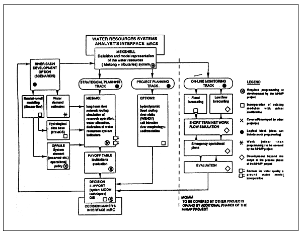
The Mekong Hydrology Model Package (MHMP) (see Figure 1) will serve the WUP and BDP as a planning tool and assist international negotiations with technical/scientific advice. The logical framework is designed to have two interfaces: The interface of the Water Resources Systems Analyst (virtually the MRCS Hydrology Unit and the experts of the PPD with their technical/scientific professional staff to service it) embeds the “shell modules”, where the preliminary setting of the subsequent computations is prepared. From this shell three possible tracks could be opened:
The strategic planning track with its inherent sequence and coupling of modules is the core task of the recommended project. Along this line both existing software modules and new routines can be incorporated. This track provides the WUP and BDP water balance type stream-flow routing and water resources management and allocation services.
The project planning tract encompasses basically the incorporation of software elements already installed at the MRCS. These mathematical model would enable more detailed (local or regional) considerations of river flow, related phenomena and water resources management actions and their consequences for detailed, individual project planning. The scope of these applications is usually only regional rather than basinwide.
The third possible track would mean an extension of the framework to become a Mekong On-line Monitoring Model.
The decision maker's interface summarizes the system output facilities designed to fulfil the needs of a multinational decision making group composed of senior experts and government officials. A feedback mechanism to define revised river basin development options (scenarios) prompts a rerun of the consequence of programmes and subroutines, thus serving decision making in an interactive manner, if needed. (The term ‘decision making group’ denotes those who will use the results of the MHMP, irrespective the actual project setup like WUP or BDP, etc.).
Description of the new modules
The MHMP framework incorporates both existing software modules and programme elements, files and subroutines to be developed or to be modified to fit the specific requirements both physically and by representing the water resources management setup of the MRCS.
MEKSHELL (Mekong Shell) is the “file and programme manager” module of MHMP. Its task is to define the representation of the water resources system: the Mekong River with its important tributaries, including system elements like reservoirs, power plants, barrages, withdrawals, return flow (at later stage interconnected aquifers, pollution sources etc.). It is suggested to extend the model representation to a resolution covered by the first and second order river gauges. (This implies that at the onset approximately 120 gauges with their respective flow records would be incorporated. The shell module serves to define the simulation mode (the track to proceed on) and to take in the system analysts' decision when to model the whole LMB or only part thereof. The development scenario (LMB configuration) to be investigated will be superimposed in this module upon the basically nodes and arcs representation of the basin drainage network. By considering its central role in the MHMP, the conception and implementation of the MEKSHELL unit will be one of the formidable tasks of the project.
MESIMO (Mekong Simulation Model). This module is the computational core of the strategic planning track. It is envisaged as simulation model. Preferably accommodating a long time series of hydrological information (inflows, evapotranspiration, rainfall, etc.) on a relatively long time step-base in order to ensure rapid execution. As far as the long-term impact analysis an aim of the MHMP is concerned, time steps of one month, 10 days (decades) or weeks could be acceptable. It is expected that this rough time discretization would not allow the proper assessment of phenomena in the Mekong Delta. Therefore, the development of a reliable MESIMO, will have to involve comprehensive testing. It is well conceivable that different part of the LMB should be modelled by using different time step length. Likewise it is conceivable to use different model approaches to simulate river and delta flows. Preferably the river network routing will rely on simplified stream-flow routing. MESIMO executes the simulation (basically the propagation of stream-flow from upstream to downstream) within the framework described by the MEKSHELL. It receives the necessary data from respective files, summarizing and locating water demands, hydrological (mainly flow) data. The consideration of the operation of incorporated system elements such as reservoirs, flow deviations, hydropower facilities (or later waste water treatments) can either be loaded from a pre-specified policy file or operational rules can be set or optimized from the MESIMO itself. By incorporating these modules, MESIMO itself assumes the role of a secondary shell programme.
MESIMO is also involved in the computation of primary water resources system performance indicators and their statistical parameters to serve as inputs for the multi-criteria assessment of the simulated scenario. While the present scope of the recommended project concentrates on quantity aspects of the water resources of the LMB provisions must be foreseen for the future incorporation of water quality modelling and the interaction between the aquifers and the surface water system. By adopting this split of quantity and quality modelling, the present proposal follows the line defined for the preparatory projects of WUP.
The OPRULE element summarizes the guideline to be taken into account in MESIMO with regard to the consideration of incorporated (major) system elements such as reservoirs, hydropower facilities, etc. It is understood that the operational management of these system elements may have a strong impact on and interrelationship with the water utilization rules to be defined by the JC. Therefore, optionally to respond directly to selected performance indicator(s) as objective function(s). Optimized operational rules can usually be derived only in an interactive way with the stream-flow simulation or have to be embedded in MESIMO.
PAYOFF is the transformation of the primary performance indicators into criteria of more general perception. In order to provide the decision's makers with a broad view, it is envisaged to characterize the simulated scenario and its basinwide impact by multiple criteria representing major economic indicators and environmental criteria and their change along the river. The number of criteria to be considered simultaneously usually should not exceed a dozen, but kept preferably around seven to comply with the average human perceptual capability.
DECISION SUPPORT Decision makers may rely on this systems analytical tool in order to help them pinpoint the preferred compromise solution. As a further option results may be visualized in a GIS framework.
Mekong River Commission flood forecasting activities
Brief history
After the severe flooding of the Mekong River in the vicinity of Nong Khai and Vientiane during the 1966 wet season, the former Mekong Committee and consecutively the Mekong River Commission (MRC) initiated a flood forecasting program for the lower Mekong River Basin beginning in January 1968. Since then forecasting operations using hydrologic models on a high speed computer have been carried out during every wet season as one of the core activities of the Secretariat. Furthermore the extensive floods in 1978 and 1981 called for an expansion of the forecasting program to cover the major tributaries and Mekong Delta area.
The forecasts are made in terms of the water level from one to five days in advance for the stations in the upper and middle reaches by a synthetic model, SSARR (Streamflow Synthesis and Reservoir Regulation), and from one day to two weeks in advance for those in downstream stations in the delta by a hydro-dynamic flow model, DELTA. SSARR has been introduced to the Secretariat by US Corps of Engineers while DELTA has been through the UNESCO's support in the late 1960s and the early 1970s. At present, only SSARR is operational at the Secretariat for the routine forecast in every wet season.
Flood monitoring and forecasting procedures
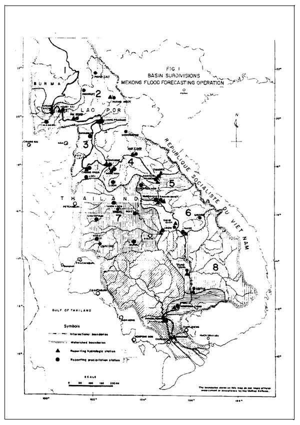
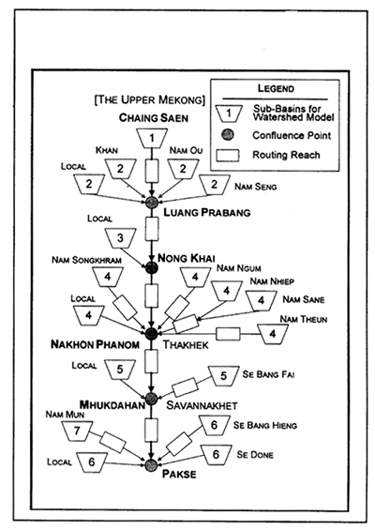
During every flood season from July to November, daily observed data from major hydrologic and meteorological stations within the Lower Mekong Basin are collected by the Hydrology Unit of the Secretariat every day at 0700 hours by radio (Figure 1). Water level monitoring stations range from Chiang Saen in Thailand to Tan Chau and Chau Doc in Viet Nam's Mekong Delta. The SSARR Model is run on a computer with this data and the forecasts for water levels will be made at ten stations along the mainstream for one to five days in advance.
The result of the calculation is transmitted to the riparian countries through their respective National Mekong Committees in a standardized reporting format within the same day. The Secretariat issues a flood warning when water levels are expected to reach a critical level. The riparian line agencies will take necessary action based on the forecast and other information available.
Cooperation framework
The flood forecasting team of the Hydrology Unit at the Secretariat is basically composed of four staff members: one supervising project officer, one meteorologist, one radio operator and one model operator. The meteorologist works on rainfall forecasts in cooperation with the Department of Meteorology in Thailand. The radio operator communicates with major field offices in the riparian countries and updates the records database. The model operator simulates flood propagation along the main channel based on rainfall and water level observations. The supervising officer reviews the results and drafts a flood warning if necessary.
Hideaki Tanaka, Senior Hydrologist, Mekong River Commission Secretariat,
Bangkok, Thailand
FIGURE 1
Flood monitoring network in 1997
The cooperating agencies in the riparian countries are as follows:
Cambodia
Cambodia National Mekong Committee
General Directorate of Irrigation, Hydrology and Meteorology
Lao PDR
Lao National Mekong Committee
Department of Meteorology and Hydrology
Division of Inland Waterways, Department of Communication
Thailand
Thai National Mekong Committee
Department of Energy Development and Promotion
Department of Meteorology
Viet Nam
Viet Nam National Mekong Committee
Southern Regional Hydro-Meteorological Forecasting Centre
As for China and Myanmar in the Upper Mekong Basin, no data exchange framework has yet been established with the Lower Mekong Countries. However, dialogue with the upstream countries has been made on a continuing basis during Joint Committee and Mekong River Commission Council meetings.
SSARR FLOOD FORECASTING MODEL
The SSARR Model is a watershed simulation model developed by US Army Corps of Engineers, North Pacific Division, around 1960. It can simulate runoff from rainfall and snow melt, and river systems including operations of reservoirs and diversions in a short- and/or longterm time scale. The time step of calculations in case of the Mekong is 6 hours.
The SSARR Model has three components: the watershed model to calculate runoff from a watershed; the channel routing model to simulate channel storage in the river; the reservoir model to simulate the effects by dam controls and natural reservoirs. Among these, the watershed model and the channel routing model are used for flood forecasting of the Mekong.
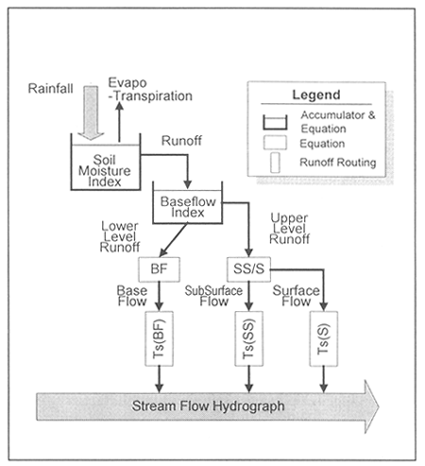
Watershed model
In the watershed model, runoff is calculated by means of parameterization of the conceptual runoff processes which occur in the basin. First the river basin is divided into sub-basins, each of which has almost homogeneous hydrologic characteristics. After calculation of the runoff from sub-basins, all the runoffs are integrated and then the final output is obtained.
The runoff calculation from the sub-basin is carried out in the following sequence: to calculate Soil Moisture Index based on rainfall and evapotranspiration, to calculate the total volume of runoff, then to separate runoff components from the total volume based on the Base Flow Index, to calculate the time lag and regression for each component, and finally to add all the components up to get the total runoff hydrograph (Figure 2).
FIGURE 2
Runoff calculation by SSARR watershed model
Channel routing model
For channel routing, the following storage function is used in SSARR. The change of storage in the channel with respect to that of discharge dS/dQ = TS is a parameter showing the hydrograph regression due to the channel storage and the time delay of the peak of the hydrograph.
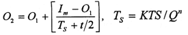 | |
| Im | = average inflow |
| O1,2 | = outflow at the beginning and end of the unit time |
| t | = unit time of calculation |
| Ts | = channel storage parameter |
| KTS | = a constant for a time lag |
| Q | = discharge |
| n | = a constant for channel routing |
Schematization of the Basin
All sub-basin and channel components in the Lower Mekong basin can be schematized by the combination watershed models and channel routing models.
Figure 3 shows the schematization of the Mekong River Basin for SSARR. The schematization is sometimes changed according to the availability of the real time data in the basin.
Calibration of parameters
Numbers of parameters are used in the watershed model and the channel routing model. Usually one component of the watershed model and the channel routing model have the following number of parameters respectively.
Watershed Model: 7 parameters and 3 functions
Channel Routing Model: 3 parameters
The initial values for these parameters and functions were empirically determined by trial and error. The values are considered unique to the Mekong Basin.
FIGURE 3
Schematization of the Lower Mekong
Hydrometeorological conditions in 1997
Meteorological conditions
In 1997, there were fewer tropical typhoons occurring in the region than usual (Figure 4). Only two typhoons, Fritz in late September and Linda in early November, directly affected the Lower Mekong Basin. Tropical troughs and strong depressions, however, were present in force.
From late July to early August, a depression developed over the Mekong Basin causing heavy rainfall in the middle reaches from about July 29 to August 3.
FIGURE 4
Typhoon tracks in 1997
In mid-August, a low pressure trough lay across northern and upper north-eastern Thailand to a low cell in the Gulf of Tonkin. As a result, heavy rain occurred in the middle reach of the Mekong from about August 13 to August 19. Daily rainfall of 160.0 mm at Thakhek and 126.8 mm at Pakse was observed on August 17.
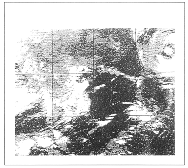
From the end of August to early September, an active low pressure trough lay across Myanmar, northern Thailand, and the Lao PDR to the Gulf of Tonkin causing widespread showers, isolated heavy rainfall and flash floods in upper Thailand and the Lao PDR (Figures 5, 6). Heavy daily rainfall was observed at Chiang Saen August 31 with 119.5 mm and at Houei Say on September 1 with 192.0 mm. At Paksane, heavy rainfall was continuously observed.
In late September, tropical depression “Fritz” brought a flash flood to the southern Lao PDR and north-east Thailand from around September 26–29. At Khon Chiam, daily rainfall of 101.7 mm was observed on September 25.
FIGURE 5
Weather chart on 17 August
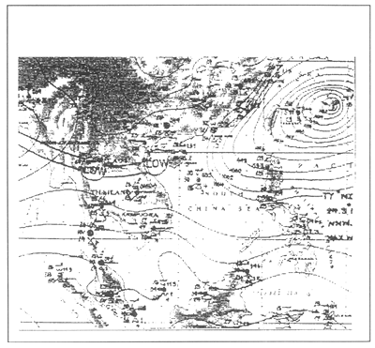
FIGURE 6
GIS imagery on 17 August
In early November, typhoon “Linda” traversed the lower South China Sea moving west. It brought a strong north-east monsoon over the South China Sea, the southern parts of Viet Nam, Cambodia and Thailand. Widespread heavy rain and rough seas were observed in this region. Many human lives were lost to Typhoon Linda.
Hydrologic conditions in 1997
Three peaks were observed in the daily water level hydrographs of major hydrologic stations: in late July, in mid-August, and in early September. These peaks are the result of the changes in the meteorological conditions described above.
From Chiang Saen to Mukdahan, stations observed heavy rainfall due to a low pressure trough in the region in early to mid-September causing the highest recorded peak in the annual hydrograph. At Paksane, the water level rose above flood stage from August 8 to 11, resulting in the highest level in recent years. Paksane has been flooded frequently in recent years.
At downstream stations from Pakse to Kompong Cham, heavy rainfall due to a depression observed in early August caused the highest peak recorded in the annual hydrograph. The water level at all the major stations along the mainstream surpassed flood stage. Notably, at Stung Treng, the highest level was above flood stage by 1.16 m on August 5, which was almost the same as the maximum in 1996.
At Phnom Penh on the Bassac, however, the water level was always lower than the flood stage. The flood mentioned above was diffused in part by overbanking into low lying land and partly by discharge into the Tonle Sap Lake.
At Mekong Delta stations, water levels surpassed flood stage from late August to late October - almost two months. While the Delta has experienced annual flooding since 1994, Typhoon Linda in early November did not affect water levels at Chau Doc or Tan Chou.
In conclusion, 1997 was a severe flood year for Cambodia's upstream areas and for the Viet Nam Delta whereas it was a moderately heavy flood year in the middle reach of the Mekong. Parts of the Mekong have been affected by flooding annually since 1994.
Flood forecasts in 1997
Evaluation of peak heights forecasts
The peak water levels calculated by SSARR for major stations stand within a reasonable range of errors (see Table 1). At some stations, SSARR has marked almost the exact value of the observed water level.
TABLE 1
Flood peak forecast by SSARR
| Station | Date of Peak | Observed GH Ho (m) | 1 Day Forecast GH Hc (m) | Deviation (m) |
|---|---|---|---|---|
| Chiang Saen | 2 Oct 97 | 7.62 | 7.64 | + 0.02 |
| Luang Prabang | 7 Sep 97 | 16.56 | n/a | n/a |
| Vientiane | 9 Sep 97 | 11.34 | 11.21 | - 0.13 |
| Paksane | 10 Sep 97 | 14.74 | 14.78 | + 0.04 |
| Nakhon Phanom | 11 Sep 97 | 12.28 | 12.21 | - 0.07 |
| Mukdahan | 11 Sep 97 | 12.32 | 12.32 | 0 |
| Pakse | 3 Aug 97 | 12.34 | n/a | n/a |
Evaluation of the 1–5 day forecast
The regression curve of the hydrograph can be moderately simulated by SSARR (Figure 7). This implies that the parameter values used in the model for the base flow index and following processes would be within the appropriate and reasonable range.
On the contrary, for the rising parts of the hydrograph and for the surrounding parts of its peaks and valleys, a good forecast was not obtained. This would be partly due to the difficulty in forecasting regional rainfall distribution and intensity, and partly due to non-calibrated parameter values for runoff in the watershed model.
FIGURE 8
1–5 day forecast of water level at Pakse in the Lao PDR (869 km)
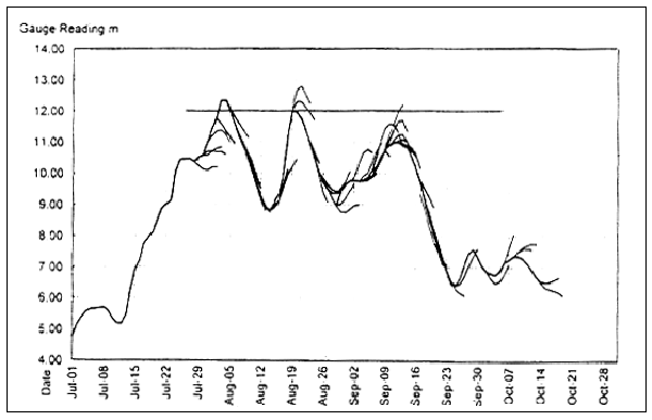
As for the 1 day forecast by SSARR, almost all the stations have the errors ranging approximately within 10–20 cm in water level on average. The over-estimations and the underestimations are, however, almost balanced as a whole so that the average of the deviations is given approximately zero or within the range of 5 cm.
For Chiang Saen and Luang Prabang, the errors of the forecast are bigger than those at the other stations. The further downstream stations have the smaller errors. Flood forecasting errors increase when the forecast operation projects for 2 or more days as compared to the 1 day forecast.
Major warnings released by MRC
On July 31 and August 5, the Mekong River Commission released flood warnings for the expected critical situations at Pakse, Kratie and Kompong Cham downstream from the heavy observed rainfall area. On August 6, the MRC released another warning for Kompong Cham. By this stage, the Cambodian Government had also announced a state of emergency for Stung Treng, Kompong Cham and Kratie. Information regarding Stung Treng, however, was not available at the MRC due to troubles with the communications system.
From August 18 until August 26, the MRC released a series of warnings and alerts for the possibly critical situations at Pakse and further downstream. However, the water level at Pakse did not rise as high above flood stage as was expected.
On September 3, the MRC released a flash flood warning for almost all major stations in the middle reach of the river. On September 5 and September 8, the MRC reconfirmed the warning for these stations again, while Thailand's Ministry of Interior issued a flash flood warning for the country's north-eastern provinces.
On September 26, the MRC released a flash flood warning for the Thai-Cambodian border areas which would be impacted by Typhoon Fritz. On releasing this warning, the MRC also provided line agencies with a precipitation forecast in the region. The rainfall distribution and intensity forecast was made by a meteorological model called the Middle Range Forecast Model. The results were also made available on the Internet. This was the first time that the MRC had provided rainfall forecasts for the Basin.
Future issues
Monitoring Network
It is critically important to maintain and improve the basin-wide flood monitoring network. A limited number of hydrologic stations are now being improved and radio systems have been provided to major stations under the terms of the ongoing project, Improvement of Hydro-Meteorological Network (basinwide). Similar network projects are necessary to continue to be implemented in order to maintain and expand the operation of the network. Especially necessary are improvements in the monitoring system of Mekong River tributaries in the Lao PDR.
A communication system linking the existing MRC-operated monitoring stations with the Upper Mekong Basin is urgently needed.
Modelling Environment
Although SSARR Model is considered as an out of date model, it is still useful for MRC and the riparian countries. The model environment of MRC should be improved with respect to the parameter calibration, the user interface, rainfall forecast system, hydro-dynamic simulation of the delta area, incorporation of the Tonle Sap Lake, and so forth.
Cooperation Framework and Dissemination
It is important for the flood forecasting system of the Mekong to strengthen the cooperation framework among MRC and the riparian line agencies, including meteorological agencies. Institutional support to the line agencies should be strengthened. The framework of cooperation should be expanded to include international organizations such as WMO and UNESCO. The dissemination system for flood warning information in the respective riparian countries should be improved to assure that local populations are better prepared for flooding.
Bibliography
US Army Corps of Engineer, North Pacific Office, 1975. Program Description and User Manual for SSARR Model, revised version.
Mekong River Commission, 1997. Lower Mekong Hydrology Yearbook 1993, pp. 477.
Introduction
Damages caused by flooding are responsible for inflicting large costs on both governments and individuals throughout the world each year. These costs are both economic, in terms of damage caused to infrastructure and disruption to essential services, and social, in terms of the destruction of homes and property and the interference to normal lifestyles.
Flood forecasting and warning systems are a cost-effective means of reducing the damaging impacts of floods. By enabling early identification of flooding and the timely protection or evacuation of potentially flood inundated area, it is possible to minimize, if not completely obviate, damages caused by flooding.
Background
The wet season of 1995 saw major flooding of the Mekong River in the Lao PDR. The townships of Paksane, Thakhek, Savannakhet, and Pakse all experienced flooding while in Vientiane the levee protecting the city came within half a metre of being overtopped.
Although gauging stations are in place on the Mekong River upstream of each of the townships affected by flooding in 1995, the absence of any effective flood forecasting procedures meant that it was not possible to identify the extent and timing of flooding on the Mekong River prior to its occurrence. This resulted in unnecessary damage to property and, in Vientiane, caused undue alarm about the potential overtopping of the levee.
In response to this situation, an AusAID project was established with the objective of developing a flood forecasting system for Vientiane and, if possible, towns further downstream including Paksane, Thakhek, Savannakhet, and Pakse. This report documents the undertaking of this project and describes the development and implementation of the resultant flood forecasting system.
Existing flood forecasting methodologies
The initial stage of the project involved the identification and review of flood forecasting procedures currently in place for the Mekong River in the Lao PDR. Two agencies are currently responsible for the estimation of forecast flood heights on the Mekong River the Department of Meteorology and Hydrology in Vientiane and the Mekong River Commission Secretariat in Bangkok.
Janice Green, Department of Land and Water Conservation, New South Wales, Australia
Department of Meteorology and Hydrology, Lao PDR
The Department of Meteorology and Hydrology in Vientiane has the responsibility for undertaking flood forecasting. At present three procedures exist which have the potential to provide flood forecast estimates for Vientiane, however, it appears that none of these procedures is actively pursued.
Stage correlation
Prior to 1980, 48 hour forecast water levels at Vientiane were estimated using a stage correlation relationship between Luang Prabang and Vientiane. The stage correlation relationship was based on a simple single step, first degree polynomial equation and did not include any real-time correction procedures.
Water balance
The method adopted since 1982, involves the estimation of heights at Vientiane 48 hours ahead using what is described as a statistical analysis of the water balance between Luang Prabang and Vientiane (Soukhathammavong, 1994).
This procedure is a two step procedure. The first step involves the estimation of the difference in the water surface elevation between Luang Prabang and Vientiane. ΔH6 assuming a travel time of 48 hours. This estimate is made using the equation (1) detailed below:
ΔH1=111.3855173+0.14680 H1 (1)
where: H1 = the daily water level at Luang Prabang
The estimate of ΔH1 is inserted into equation (2) to determine the 48 hour forecast height on the gauge at Vientiane, HV:
HV= [(H1 + 267.195) - ΔH1] - 158.04 (2)
where 267.195 and 158.04 are the elevations of the gauge zero for the Luang Prabang and Vientiane gauges respectively.
A real-time correction of the data is performed depending on whether the observed elevation at the Vientiane gauge is above or below 114.00 metres. If the observed elevation at the Vientiane gauge is below 114.00 metres the forecast is adjusted by 10% to 20%. If the observed elevation at the Vientiane gauge is above 114.00 metres the forecast is adjusted by 25% to 30%.
The procedure outline above was determined using recorded height data from the Luang Prabang and Vientiane gauges for the period 1960 to 1982. The data adopted were as follows:
The correlation coefficient, r, for equation (1) is 0.818 which corresponds to a coefficient of determination., r2, of 0.699. In general, it is considered inadvisable to adopt regression relationships where the coefficient of determination is less than 0.85. The inadequacy of the relationship defined by equation (1) is shown by the results using this procedure for 1982 where the errors in the forecast heights ranged from -22% to +40%.
Sacramento model
The Department of Meteorology and Hydrology has been provided with a copy of the Sacramento Model and suitable hardware to run the software. However, it appears that insufficient training has been provided to allow the Department to utilize this package.
The Sacramento Model is a rainfall-runoff model developed by the National Weather Service, California, USA (Burnash, 1973). It is used in the United States by the National Weather Service River Forecast System as one of a suite of models adopted for flood forecasting.
In general, rainfall-runoff routing models produce less accurate flood forecasting results than other methods which utilize recorded streamflow data. They are adopted in headwater basins where the absence of upstream gauging stations makes it necessary for streamflow data to be generated.
The use of the Sacramento Model for flood forecasting on the Mekong River is considered to be neither necessary nor appropriate.
Streamflow synthesis and river regulation (SSARR)
Training in the use of the flood forecasting program., SSARR, adopted by the Mekong River Commission Secretariat (see below) was apparently given to staff in Vientiane, when the model was first applied to the Mekong River, by the US Army Corps of Engineers in the early 1970s. It was not possible to ascertain whether a copy of the model resides with the Department of Meteorology and Hydrology, however, in the absence of follow up training and hands on experience it is considered that the model would have become obsolete.
Mekong River Commission Secretariat
The flood forecasting method adopted by the Mekong River Commission Secretariat in Bangkok uses the Streamflow Synthesis and River Regulation model (SSARR) (US Army Engineer Division, 1972). This model was applied specifically to the Mekong River in the early 1960s and subsequently adopted by the Mekong River Commission Secretariat as its flood forecasting tool (US Army Corps of Engineers, 1971).
The SSARR model comprises three basic components:
A generalized watershed model for synthesizing runoff from snowmelt, rainfall, or a combination of the two.
A river system model for routing streamflows from upstream to downstream points through channel and lake storage.
A reservoir regulation model.
Inputs to the model include catchment details pertaining to net basin precipitation -observed and forecast, soil moisture, evapotranspiration loss, runoff excess, surface storage, subsurface storage, groundwater storage, and surface, and base-flow routing characteristics. Appropriate parameter values were determined by the US Army Corps of Engineers during the application and calibration of the SSARR model to the Mekong River.
The model uses ten day rainfall forecasts provided by the Meteorology Unit of the Mekong River Commission Secretariat to produce estimates of discharges at specified locations. These discharge estimates are subsequently converted to river heights. Real-time correction of the forecasts is undertaken subjectively at two steps in the procedure. An initial adjustment of the forecast discharges is made by factoring the forecast rainfall depths and a second adjustment is made to the resultant river heights. These corrections are made based on the experience of longterm hydrologists within the Secretariat.
Ten day forecasts of river heights are currently made by the Mekong River Commission Secretariat during the months of June to November for the towns of Chiang Saen, Luang Prabang, Chiang Khan, Vientiane, Nong Khai, Paksane, Nakhon Phanom, Thakhek, Mukdahan, Savannakhet, and Pakse. Five day forecasts are provided by the Mekong River Commission Secretariat to each of these towns on a daily basis.
A review of the 1995 forecasts indicated the accuracy of the estimates produced by the SSARR model ranged from -15% to +10%. However, it is considered that this degree of accuracy is dependent largely on the expertise of hydrologists familiar with the river system rather than on any inherent accuracy of the model itself. As with any system which relies on experience methods, the absence of the experienced forecaster can have a significant impact on the accuracy of the forecasts. The retirement in 1997 of the most experienced forecaster at the Secretariat will undoubtedly result in a decrease in the accuracy of the estimates provided.
It is also of concern that a reassessment of the parameter values adopted in the SSARR model does not appear to have been undertaken to take into account changes in catchment characteristics over recent years. In particular, it would be expected that deforestation of large parts of the catchment would have had a significant effect on catchment response and that the parameter values adopted in the model may no longer be appropriate. This in turn would have an impact on the accuracy of the forecasts produced by the model.
Streamflow data
General
Responsibility for the collection of streamflow data within the Lao PDR is divided between the Department of Meteorology and Hydrology and the Ministry of Communication, Transport. Post, and Construction.
Streamflow data from gauging stations located on the mainstream of the Mekong River are collected by the Ministry of Communication, Transport, Post, and Construction. The Department of Meteorology and Hydrology has responsibility for the collection of streamflow data from tributaries of the Mekong River.
Data collected by both bodies are forwarded to the Mekong River Commission Secretariat for computer archiving and value adding.
In addition to the streamflow data collected by the Lao PDR, data from the main stream and from tributaries on the Thai side are collected by the relevant agencies in Thailand. On the mainstream it is common for both the Lao PDR and Thailand to be operating gauging stations at adjacent locations (for example, Vientiane and Nong Khai, Nakhon Phanom and Thakhek, and Mukdahan and Savannakhet), however, it is usual for the Lao operated gauging stations to be unrated.
As with data collected within the Lao PDR, the data collected by Thailand are also forwarded to the Mekong River Commission Secretariat.
Obtainment of data
Data from streamflow gauging stations located on the mainstream of the Mekong River and its tributaries, on both the Lao and Thai sides, for the reach of river from Luang Prabang to Pakse were obtained from the computer archive at the Mekong River Commission Secretariat in Bangkok, height data were obtained for all of the stream gauging stations. For those stations for which a rating curve had been derived, discharge data and rating curve details were also obtained. Data for the complete period of record for each gauging station were obtained in order to ensure that representative data were used in the development of the flood forecasting procedure.
Review of data
Prior to the application of the streamflow data in the development of the flood forecasting procedure, the data were reviewed. 'The data review was undertaken to ensure that the discharge and height data were representative of the river system and that they formed a homogenous data set. A range of statistical analyses were undertaken in the review including single, double, and residual mass curve analyses.
For the gauging stations for which it was applicable, a review of the rating curve was also undertaken. This review involved an assessment of the gauging data used in the derivation of the rating curve, the appropriateness of the adopted curve, the degree of extrapolation of the curve, and the method used in the extrapolation. In general it was found that the height and discharge data gave a representative and homogenous data set and were of a standard reasonable enough to allow adoption. The rating curves were also found to be of an acceptable accuracy.
Flood forecasting methods
General
Flood forecasting methods can be broadly separated into two classes - rainfall runoff methods and flood routing methods.
Rainfall-runoff methods utilize rainfall data to generate streamflow discharges. Real-time forecasts of discharge, obtained by rainfall-runoff methods are generally less accurate than those obtained using observed data at an upstream gauging station and tend to be adopted in areas for which there is no or inadequate discharge data available or where the catchment response times are very quick.
Flood routing methods utilize observed discharged or height data at upstream gauging stations to predict the size and arrival time of flood waves at a downstream site. Flood routing offers a satisfactory means of flood forecasting for long river systems. The flood routing methods can be classified under four headings - experience methods, statistical methods, hydrologic routing methods, and hydraulic routing methods.
Adopted Methodology
For flood forecasting on the Mekong River, flood routing methods were considered to be more appropriate than rainfall-runoff methods. Of the four types of flood routing methods, statistical methods were considered to be the most suitable given the requirements of the flood forecasting procedure, the time constraints of the project and the available data.
It was considered that the subjectivity and reliance on long-term staff of experience methods precluded the use of these methods. Hydraulic river routing methods were excluded due to their complexity and dependence on high quality discharge data.
Hydrologic routing methods were considered but rejected because of their reliance on discharge measurements. Along the section of the Mekong River from Luang Prabang to Pakse, there are located seventeen gauging stations. Of these seventeen only eight have had rating curves derived and as a consequence only height data is available from the remaining nine gauges. More importantly, of the eight streamflow stations for which discharge data were available only three - at Luang Prabang, Vientiane and Pakse - were operated by the Lao PDR.
An essential criterion for the flood forecasting procedure is that the data that are required to operate it are readily available, particularly during times of high flows. It was considered that the requirement to obtain discharge data from the relevant Thai agencies would add an additional complication to the process of flood forecasting which had the potential to negate the effectiveness of the procedure.
Even if appropriate discharge data were readily available, the dependency of the data on accurate and stable rating curves would have added an additional potential source of error to any flood forecasting procedure which relied on discharges. Inaccuracies in rating tables could result in the accumulation of errors resulting in larger errors in forecast height.
Statistical methods
The statistical method selected for adoption in the development of the flood forecasting procedure for the Mekong River was the correlation method. Correlation methods are widely used by flood forecasting agencies in Australia and a simplified version of this method is what is currently used by the Department of Meteorology and Hydrology.
In this correlation method the correlation between upstream and downstream river levels is used to forecast the flood levels at the downstream site. The downstream river levels are plotted against the upstream river levels with the upstream river levels being the dependent variable and the downstream river levels the independent variable. A regression line is drawn through the points using the method of least squares. Typically the type of regression line which is fitted to the data points is a polynomial curve of the first, second, or third order.
Correlation relationships were derived for the sets of data shown in Table 1.
A range of correlation relationships were tried to determine the optimal fit for each set of data. These included using a split regression, where different relationships were derived for different height ranges and using different orders of polynomial equations, in general, the complete set of data from each station was used to determine the regression relationship.
However, for stations for which long periods of record existed shorter periods of more recent data were also tried in order to identify possible changes in the relationships over the period of record. In addition, both the whole year data set and the data set pertaining to the wet season months of June to October were tried.
TABLE 1
Stations used for derivation of correlation relationships
| Upstream station name | Upstream station number | Downstream station name | Downstream station number |
| Luang Prabang | 011201 | Vientiane | 011901 |
| Vientiane | 011901 | Paksane | 012703 |
| Paksane | 012703 | Thakhek | 013102 |
| Thakhek | 013102 | Savannakhet | 013401 |
| Savannakhet | 013401 | Pakse | 013901 |
The ‘goodness’ of the fit of the regression relationship was assessed by the value of the coefficient of determination, r2, and by the degree to which the resultant polynomial curve(s) described the complete set of data. Although the objective was to achieve the optimal fit possible over the whole range of data, where it was necessary to compromise this objective, priority was given to reproducing the high flows. The rationale behind this decision was that in a flood forecasting procedure it is accurate reproduction of high flows which is the main criterion rather than reproduction of low flows.
Details of the regression relationships adopted for the pairs of stations listed in Table 1, the period of record used, and the coefficient of determination are shown in Table 2.
TABLE 2
Correlation relationships
| Stations | Period of record | Months of record | Lag | Range of relationship | Regression Relationship | Coefficient of determination |
|---|---|---|---|---|---|---|
| Luang Prabang-Vientiane | 1960 – 1992 | June - October | 2 days | 0 – 14 metres 14 – 18 metres > 18 metres | y = 0.08453x - 2.0794 y = 0.6757x - 0.2089 y = 0.1309x + 9.7821 | 0.9829 0.9409 0.9374 |
| Vientiane-Paksane | 1976 – 1992 | June - October | 1 day | Complete range | y = 0.0018x3 + 0.0247x2 + 0.9348x + 1.7297 | 0.9188 |
| Paksane - Thakhek | 1976 – 1992 | June - October | 1 day | Complete range | y = -0.0002x3 + 0.0062x2 + 0.9042.x + 0.8187 | 0.9399 |
| Thakhek-Savannakhet | 1972 – 1992 | June - October | 1 day | Complete range | y = -0.0022x3 + 0.0401x3 + 1.1823x - 0.9904 | 0.9904 |
| Savannakhet-Pakse | 1972 – 1992 | June - October | 1 day | Complete range | y = -0.0001x3 + 0.0032x2 + 1.0668x + 0.9312 | 0.9312 |
εt = the error at time, t
As can be seen from Table 2, good results were obtained using the correlation method. The lowest coefficient of determination value was 0.9188 and the highest 0.9904. This compares very favourably with the coefficient of determination of the method currently used by Department of Meteorology and Hydrology which has a value of 0.699.
On the basis of these results it was thought that the regression relationships could confidently be adopted in a flood forecasting procedure for the Mekong River.
Real-time correction
A major problem which often occurs in real-time flood forecasting is that the forecasted value is different from the observed value when the latter becomes available. This difference is due to:
These differences will occur with all flood forecasting systems, regardless of the method adopted, because of the underlying fact that they are attempting to predict the unknown.
In light of this, an important component of any flood forecasting system is the real-time correction procedure. This procedure takes into account the errors between the computed and observed heights and enables the correction of the values computed by the flood forecasting. A wide range of procedures have been applied in flood forecasting systems around the world. The procedure adopted for the Mekong River was one which applied the correction to the output variables using the errors observed in previous timesteps such that
Hft+1 = Hit+1 + εt
where: Hft+1 = the final height forecast at time, t+1
Hit+1 = the initial (or unconnected) height forecast at time, t+1
This procedure has been widely used and was selected for its robustness.
Description of flood forecasting system
In developing the flood forecasting system for the Mekong River between Luang Prabang and Pakse, the objective was to develop a system that was both easy to use and robust.
The Microsoft spreadsheet package, EXCEL, was selected for the flood forecasting system as it is readily available, is user friendly', and has a very short learning curve. More sophisticated programs and packages were considered but rejected because it was considered that their increased complexity did not result in a concomitant increase in accuracy but rather only served to make their application more arduous.
A series of five worksheets was set up for the five reaches of river for which regression relationships had been derived. These sheets access the observed data and time and date of observation and, using the appropriate regression relationship, make an initial height forecast. The initial height forecast is then adjusted using the real-time correction procedure and the final forecast for all five locations is written to a forecast summary sheet. For each of the five worksheets there is a corresponding chart where the observed, initial forecast, and final forecast heights are plotted.
The forecast summary sheet, as well as displacing the forecast height, and date and time of forecast, also presents an assessment of the river height state. The river height states are based on proximity of the forecast height to the critical and overbank heights at each of the five primary locations as detailed in Table 3.
If the forecast height is lower than the critical height, a river height state of ‘low’ is produced; between the critical height and overbank height, a river height state of ‘critical’; and at or above the overbank height, a river height state ‘danger’.
TABLE 3
Critical and danger heights
| Location | Critical Height (m) | Overbank Height (m) |
| Vientiane | 11.50 | 12.50 |
| Paksane | 12.80 | 13.50 |
| Thakhek | 13.00 | 13.50 |
| Savannakhet | 12.00 | 12.50 |
| Pakse | 11.00 | 12.00 |
For the user, operation of the flood forecasting system requires only the inputting of the observed river heights at Luang Prabang, Vientiane, Paksane, Thakhek and Savannakhet, together with the date and time of observation. The flood forecasting system automatically determines the forecast height and river height state for each location with the user only needing to read the values from the relevant worksheet.
The hood forecasting system has been set up to be operated only during the months of Jun to October inclusively. While ordinarily only a single height reading will be made each day, the system is capable of utilizing the four hourly readings which are frequently taken during the months of September and October.
The procedure to be followed by Department of Irrigation staff in the application of the flood forecasting system is detailed in Appendix A.
Testing of flood forecasting system
Historic floods
Subsequent to the development of the flood forecasting system, the system was tested using observed floods. For each of the five locations, the system was tested for each of the three largest recorded floods in order to assess the system's ability to forecast extreme river heights. In addition, the system was also tested using, the recorded heights from the years 1988–1992 inclusively, these years corresponding to those for which the most recent data are available. This second test undertaken in order to assess the systems performance under current catchment conditions.
TABLE 4
Results of flood forecast system testing
| Station | Mean error of forecast (metres) | Standard deviation (metres) | Relative mean absolute error | Average range of error (%) |
| Vientiane | 0.001 | 0.21 | 0.031 | -10% to +9% |
| Paksane | 0.002 | 0.24 | 0.028 | -13% to +14% |
| Thakhek | 0.001 | 0.23 | 0.019 | -15% to +14% |
| Savannakhet | 0.001 | 0.15 | 0.017 | -9% to +8% |
| Pakse | 0.002 | 0.26 | 0.025 | -14% to +10% |
The system's performance was assessed by analysing the forecast errors in terms of the mean error, standard deviation from the mean, relative mean error of forecast, and relative mean absolute error. These represent some of the parameters most commonly used in the assessment of flood forecasting models. The values obtained from these tests for each of the five locations are detailed in Table 4.
‘Dry’ running
In order to familiarize Department of Irrigation staff with the operation of the flood forecasting system, ‘dry’ runs were performed. In these, the staff operated the system as they would during each wet season but using historic data rather than real-time data. This exercise allowed the identification and rectification of problems encountered by the staff in the application of the system.
ACCURACY OF FLOOD FORECASTING SYSTEM
As shown by the results in Tables 2 and 4 the model forecasts river heights with a degree of accuracy which falls within the range considered acceptable.
However, in applying the developed flood forecasting system to the Mekong River the inherent inaccuracies in any flood forecasting system should be borne in mind. The perfect forecasting of heights is an unobtainable objective. The more realistic objective underlying the development of any flood forecasting system is the minimizing of forecast errors. In this, the flood forecasting system developed for the Mekong River is no exception.
The flood forecasting system for the Mekong River has been developed with the objective of producing a system which is robust and easy to use, it is considered that this objective has been achieved, however, it's achievement will undoubtedly have had some impact on the accuracy of the resultant forecasts.
Two areas of potential inaccuracies which have been identified are described below:
The flood forecasting system for the Mekong River from Luang Prabang to Pakse has been developed and tested using historic data. A major deficiency in the process has been the absence of recorded data post 1992. This deficiency may have an impact on the application of the system to current conditions.
The forecast estimates for Paksane, while adequately reproducing historic floods, are likely to be less accurate in the future due to the releases which are made from the Nam Ngum Darn. Although every effort was made to incorporate flows from the Main Ngum in the forecasting of heights at Paksane, the lack of long term, good quality data made this unachievable. This problem is compounded by the 1995 diversion of the Nam Song to the Nam Ngum upstream of the darn. it should be noted that this deficiency only affects the forecast estimates at Paksane. The forecast estimates at Thakhek, Savannakhet, and Pakse are unaffected as they are based on heights which implicitly include the releases from the Nam Ngum Dam.
Recommendations
The flood forecasting system for the Mekong River from Luang Prabang to Pakse has been developed within the objectives and the time constraints of the project proposal. However, it is considered that it would be prudent for a review of the performance of the flood forecasting system to be undertaken late in the 1996 wet season.
As discussed above, the flood forecasting system has been developed using pre-1992 data. A review of the system undertaken in late 1996 would enable an assessment to be made of systems performance under current climatic and catchment conditions and any necessary modifications performed.
In addition, the proposed review would enable an appraisal of the performance of the system under real-time conditions and the identification and rectification of any difficulties encountered by Department of Irrigation staff in the application of the system. It is estimated that such a review could be undertaken in one week at a cost of US$6500.
References
Soukhathammavong, K., 1994. Flood Forecasting for Vientiane Municipality, Department of Meteorology and Hydrology, Ministry of Agriculture and Forestry, Lao PDR
Burnash, R.J.E., Ferral, R.L., and MeGuire, R.A. 1973. A Genera/ised Streamflow Simulation System, Joint Federal-State River Forecast Center, Sacramento, California.
US Army Engineer Division, 1972. Program Description and User Manual for SSARR Model. Streamflow Synthesis and Reservoir Regulation. US Army Engineer Division, North Pacific, Portland, Oregon.
US Army Corps of Engineers, 1971. Runoff Evaluation Streamflow Simulation by Computer. US Army Corps of Engineers, Portland, Oregon.
APPENDIX A
Operating Instructions for the Mekong River Flood Forecasting System
Step 1: Each year the system is to be operated every day from 1 June until 31 October.
Step 2: Each morning at 09:00 hours the operator is to telephone the gauge reader at the following stream gauges: Luang Prabang, Vientiane, Paksane, Thakhek, Savannakhet, Pakse
Step 3: The operator is to get from each of the gauge readers the following information:
Step 4: The operator is to open the Flood Forecasting spreadsheet.
Step 5: The operator is to enter the following information onto the ‘Observed Data’ worksheet:
Date of river height reading.
The date must be entered in the format mm/dd/yy. For example the date 10 June
1996 would be entered as 6/10/96
Time of river height reading.
The time must be entered in the format hh:min. For example, nine o'clock in the
would be entered as 9:00
River height at each location: Luang Prabang, Vientiane, Paksane, Thakhek, Savannakhet, Pakse.
Step 6: The operator should go to the ‘Forecast’ worksheet and read the most recent Forecast height and the ‘River Height State’.
Step 7: If the ‘River Height State’ for any of the towns is ‘Critical’ or ‘Danger’ the operator must notify Mr Thanousay Ounthouang immediately.
Step 8: The operator must:
Introduction
A large area in the northern part of Viet Nam's Mekong Delta is flooded annually when the water level in the main channels rises above the river and canal banks. The flooded area is from approximately 1.2 million ha to 1.8 million ha in high flood years, and flooding lasts from two to six months with water depths between 0.5 and 4.0 m. Flooding has serious negative impacts on production and on the lives of the people. In the past, the flooded areas were almost unproductive or planted with very low yield floating rice. Since the 1980s, as the result of many projects funded by the Government to exploit the Plain of Reeds, the Long Xuyen quadrangle, and the Trans-Bassac area, water control structures have begun to promote development with a new perspective. Double or triple cropping patterns using high yielding varieties has been practised in the flooded area and has contributed to a rise of the Mekong Delta's rice production from 4.6 million tons in 1976 to 15.2 million tons in 1996. Annually, floods still cause serious losses in terms of production, infrastructure damage and human lives. In recent years, particularly in 1994, 1995 and 1996, hundreds of people were flood Victims. Total losses amounted to hundreds of million US dollars. Nevertheless, floods also have positive effects. Floodwaters carry sediments to enrich the rice fields, increase aquaculture production, leach toxic ions from acidic soils and generally cleanse the land.
While flood control in the Mekong Delta has been the focus of many studies carried out by various Vietnamese and international agencies, only preliminary conclusions have been determined from them. How to minimize the negative impact and maximize benefits of Mekong River floods in the Delta is the main concern in Viet Nam's flood control planning.
For this planning exercise, a mathematical model that can simulate flood flows in the river and canal network as well as across the vast submerged ricelands, and predict the effect of flood control measures, is very important.
The first flood model for the Mekong Delta was developed in the 1960s by SOGREAH (Sogreah, 1962). The large scale and the complexity of the problem made this model famous and well known worldwide for some decades. However, the flood flow in the Vietnamese Mekong Delta had not been very well simulated yet in that model. Nowadays, the model scheme must be fundamentally changed due to new canals, dikes and roads developed in the flooded areas.
Nguyen Xuan Hien, Hydraulic Modeller, Sub-Institute for Water Resources Planning and
Management, Ministry of Agriculture and Rural Development, Ho Chi Minh, Viet Nam
Resources Planning and Management, has been used in flood control planning in the Mekong Delta as well as in a number of water control studies in Vietnam. This paper will introduce flood flow modelling using this model and its application in flood control planning.
Flood flow modelling for the mekong delta
The VRSAP program
The VRSAP program has been developed by Professor Nguyen Nhu Khue and the modelling group of the Sub-Institute of Water Resources Planning and Management to simulate both flow and salinity in open channel systems. The program is based on an algorithm to solve onedimensional Saint-Venant equations. The flow equations are solved with the Preissmann four point implicit finite difference scheme. A six-point finite difference scheme is used to solve the advection-diffusion equation which is used to describe salinity intrusion.
Two types of data are required for the model: topographic data comprising the configuration of canals, rivers and flood plains; and hydrological data comprising water level, discharge and salinity at certain locations. The program can simulate effects of water control structures, rainfall on flood plains and canal systems, drainage and abstractions for irrigation water. Boundary conditions for flow simulations can be described by either flow discharges or water levels.
The VRSAP model has been used in a number of water control studies in Viet Nam on both low flow saltwater intrusion, and flood flow, such as:
salinity intrusion studies in the Mekong Delta, supported by the Australian Government through the Interim Mekong Committee from 1981 to 1991;
eco-development planning and pre-feasibility studies of water control in the Quan Lo-Phung Hiep area of the Mekong Delta, supported by the Mekong Secretariat and Canada's CIDA;
the UNDP-supported Mekong Delta Master Plan project studied by NEDECO of the Netherlands, 1990–1993. In this project, the VRSAP model was used to simulate the flood flow and the low flow, including salinity intrusion;
the study of flood control planning for the Mekong Delta, a high priority study of the Vietnamese Government;
flood flow and low flow-salinity intrusion studies in the Saigon-Dong Nai Basin;
the drainage studies of storm-generated rain water in the Nhieu Loc Thi Nghe canal system and the Tan Hoa Lo Gom canal system in Ho Chi Minh City; and
water resources development projects in the Mekong Delta and the Saigon-Dong Nai Basin.
Schematization and boundaries of the flood model
The flood flow model includes the following parts of the Mekong Delta:
The entire Mekong River system from Kratie to the sea, including the Great Lake and the Tonle Sap, as well as some other main tributaries such as: the Prek Dang Kom, the Prek Ou Mal and the Mui Kom Pul between the Mekong River and the Tonle Sap. Tonle Toch, Stung Siot, Trabek are on the left, while Prek Thnot, Takeo and Chau Doc are on the right, together with the flood plains in Cambodia.
The East and West Vai Co rivers, the primary and secondary canal systems, the road network and flood plains in the Plain of Reeds, the Long Xuyen quadrangle and the area between the Bassac and Mekong rivers to the downstream limits of the flooded areas.
Topographic data for Cambodia were extracted from the Sogreah Model analysis in the early sixties. For the Vietnamese portion of the Delta, the most up-to-date information from 1996 was taken into account. The present flood model is comprised of 1 560 segments, 1 278 nodes and 333 storage plains. The flood flow model scheme is presented in Figure 1.
Boundaries of the VRSAP flood flow model for the Mekong Delta are: the river discharge at Kratie, the Great Lake, Prek Thnot and Takeo; sea level in the South China Sea and the Gulf of Thailand, and rainfall data for the entire Mekong Delta.
Calibration of the flood model
The flood model is calibrated with data for the high flood years of 1978, 1984, 1991, 1994 and 1996. Results of 1994 and 1996 flood simulations are presented in this paper.
A problem in flood modelling in the Mekong Delta is the lack of updated topographic and hydrological data in regard to Cambodia. In the flood season of 1994 and 1996, only water level information from Kratie, Kompong Cham, Prek Dam and Phnom Penh is available. Data on discharge and rainfall in Cambodia is not available.
Therefore, discharges at the Kratie boundary in 1994 and 1996 were determined from the old Q-H rating curve at Kratie and verified with results from the regression method. Figure 2 presents the variation of discharges at Kratie in the 1961, 1978, 1994 and 1996 floods.
In the Vietnamese Mekong Delta, the main input data of the flood model are available, topographic map at scale 1/25 000 and cross-sections of over 3 000 km of river/canal were measured during the past 10 years. Topographic data of the main roads, including bridges and sluices in the flooded areas are also available. There are many permanent water level and rainfall stations, and during the flood season, the specific activities were carried out to measure inflow and outflow of the Long Xuyen quadrangle and the Plain of Reeds.
Examples of simulation of floods in 1994 are presented in Figures 3 to 6. In general, water levels are well simulated at most stations along the main rivers, in the Plain of Reeds and the Long Xuyen Quadrangle, including the areas with strongly tidal affect. While the simulation of flows are more difficult to accomplish than of water levels, the results can nonetheless be acceptable.
Characterization of floods in the Mekong Delta by modelling
In flood season the river system does not have sufficient capacity to discharge the total amount of water. Consequently, this results in storage and overland flow in flood plains in Cambodia. and Viet Nam. The flooding starts downstream of Kompong Cham in Cambodia. From Kompong Cham, the flood is regulated by many large depressions:
FIGURE 1
Flood flow model for the Mekong River Delta
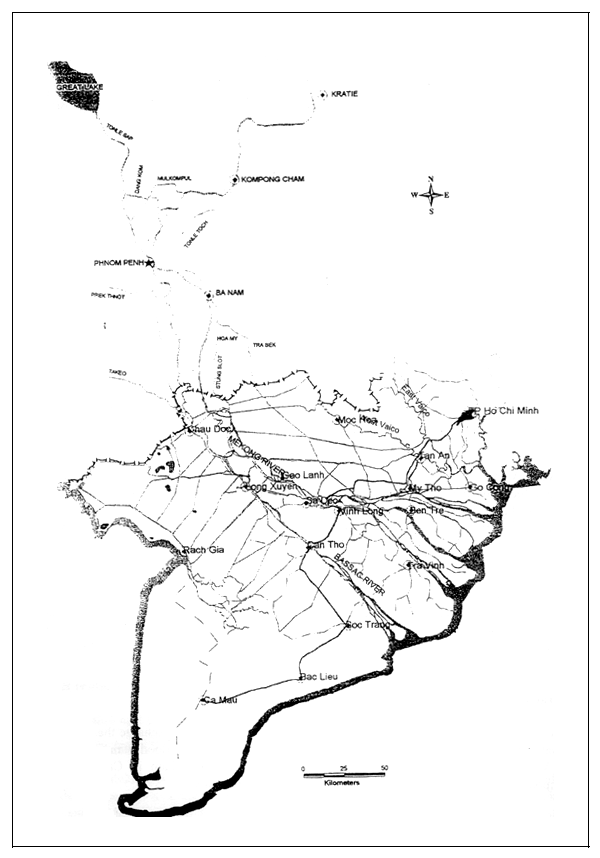
FIGURE 2
Simulation of the 1961, 1978, 1994 and 1996 floods. Discharge at Kratie
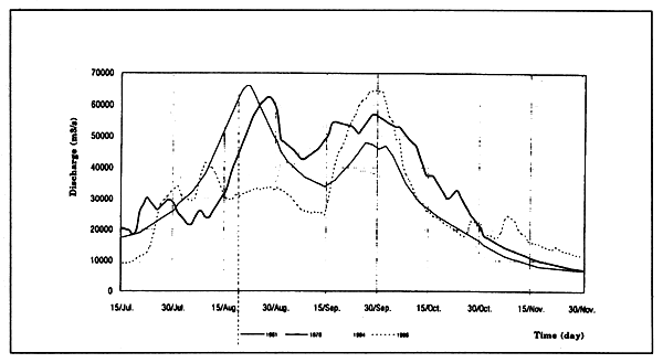
FIGURE 3
Simulation of the 1994 flood: Phnom Penh Station
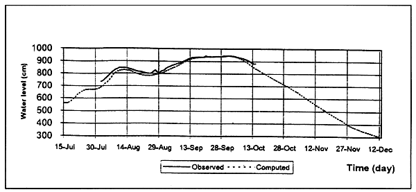
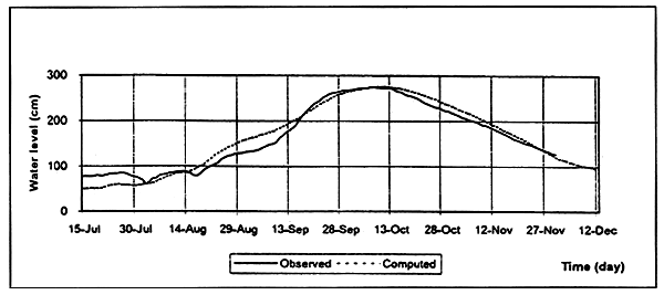
FIGURE 4
Simulation of the 1994 flood: Chau Doc Station
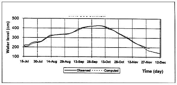
FIGURE 5
Simulation of the 1994 flood: Tan Chau Station
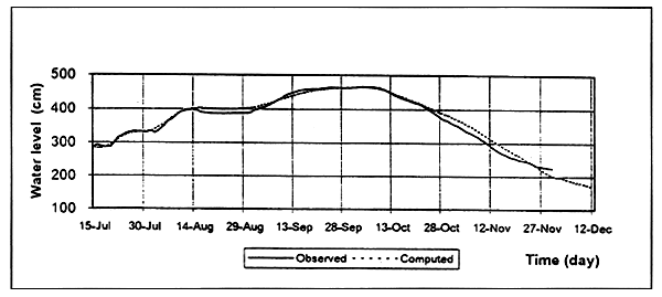
FIGURE 6
Simulation of the 1994 flood: Moc Hoa Station
On the left side of the Mekong River, the Tongle Toch River from 9 km downstream of Kompong Cham runs parallel with the main river and submerges a large low-lying area at Prey Veng, then reconnects to the Mekong River at Ban Nain.
On the right side of the Mekong River, the Prek Dang Kom, Prek Ou Mal and Mul Kom Pul rivers submerge the area between the Mekong and Tonle Sap Rivers.
The Great Lake, connected to the main river by the Tonle Sap, plays a very important role in floodwater regulation. At an elevation of +11.0 m, the lake has 12 000 km2 of water surface with a volume of 80 billion m3. From May until September, Mekong water feeds into the Great Lake. From October until the following April it drains back into the Mekong.
In the first half of the flood season, maximum flow into the Great Lake can reach 11 000 m3/s, and causes a reduction in the peak of the flood downstream. Outflow from the Great Lake usually occurs in late September or early October. Highest outflow from the lake is about 10 000 to 12 000 m3/s. The effect of the Great Lake in reducing the flood peak is significant for early, fast and high floods, as in 1978, but is less effective for slowly rising floods, as in 1994. Flooding conditions become more serious if the second peak of flood occurs when the Great Lake is already full and starts to release water into the Mekong River.
Downstream of Phnom Penh, about 80 to 85% of the total flow drains through the Mekong while only 15 to 20% passes through the Bassac. This distribution is changed downstream in the Vietnamese Mekong Delta. About one-third of the discharge in the Mekong is transferred into the Bassac through the Vain Nao. Further downstream, after draining into the Plain of Reeds and the Long Xuyen Quadrangle, the river discharge at My Thuan in the Mekong and at Can Tho in the Bassac is about the same.
Before entering the Vietnamese Mekong Delta, on the left side of the Mekong River, water flows in the Stung Slot River (or Tonic Pro Sat River) to the South. Near the Cambodia-Viet Nam border, water in the Mekong overflows the low riverbank and drains into some canals connecting with the Stung Slot River. It combines with floodwater from upstream of the Stung Slot and submerges a large area along the border of the two countries. After that, most of the floodwater flows into the Plain of Reeds through the low embankment of the So Ha Canal. This is the main source of flooding and causing severe damages in the Plain of Reeds. The remainder flows into the So Thuong River and back to the Mekong River.
On the right of the Bassac, flow from the Prek Thnot River originates in the western Delta, combines with flow from canals conveying flood flow from the Bassac downstream in parallel with the Bassac River. It then connects with the Chau Doc River in Viet Nam and, near the border, with the Ta Keo River, originating in the south-west hills of Cambodia. The flows of all these tributaries connect and submerge a large area at the border, with the main flow crossing beneath seven bridges on the Chau Doc-Tinh Bien road into the Long Xuyen quadrangle, a portion flowing through the Vinh Te Canal to the Gulf of Thailand, and the remainder flowing back to the Bassac River.
Flood enters Viet Nam following the Bassac and Mekong rivers and two large overland flows: on the left to the Plain of Reeds, on the right to the Long Xuyen Quadrangle. Inundation maps are shown in Figure 7 and Figure 8. The distribution of inflow and outflow in the Vietnamese Mekong Delta in the 1996's flood season is listed in Table 1 and shown in Figure 9.
For four and a half months (16 July to 1 December) in 1996, a total volume of 352 thousand million m3 entered into Viet Nam's Mekong Delta by two ways:
through the Mekong and Bassac Rivers, 309 thousand million m3 (88%);
from the flooded areas in Cambodia, 43 thousand million m3 (12%), in which 27 and 16 thousand million m3 flowed into the Plain of Reeds and the Long Xuyen Quadrangle, respectively.
Floodwaters enter the Plain of Reeds by two means:
Flood water in the Plain of Reeds drains out mainly into the Mekong River through many canals across national road No. 30 from An Phong to An Huu, 9.1 thousand million m3 (29%) and across National Road No. 1 from An Huu to Long Dinli, 10.8 billion m3 (34%). The remaining of 11.6 thousand million m3 (37%) discharges into the two Vai Co rivers.
FIGURE 7
Maximum flooding in Viet Nam's Mekong Delta, 1994
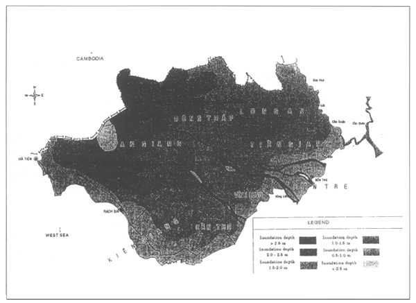
FIGURE 8
Maximum flooding in Viet Nam's Mekong Delta, 1996
FIGURE 9
Distribution of maximum discharge and total volume in the 1996 flood
TABLE 1
1996 flood season flow distribution in Vietnam's Mekong Delta (results from the model)
| Inflow/Outflow | Maximum flow Qmax (m3/s) | Total volume W(106m3) |
|---|---|---|
| Inflow through Mekong and Bassac rivers Mekong at Tan Chau Bassac at Chau Doc Canals in Tu Thuong | 34 451 23 623 8 236 2 592 | 309 000 235 200 68 000 5 800 |
| Inflow into Long Xuyen Quadrangle Across 7 bridges on Chau Doc-Tinh Bien road Through Tin Ve canal at Tinh Bien Through canals from Can Thao to Cai San | 4 437 2 521 981 935 | 20 800 11 600 4 100 5 100 |
| Outflow from Long Xuyen Quadrangle Through canals from Ha Tien to Cai San Across Cai Sai road | 4 124 3 288 836 | 21 500 17 700 3 800 |
| Inflow into Plain of Reeds Through canals from Hong Ngu to Tan Thanh Through canals from Cai Cai to Long Khot Through Hong Ngu, Dong Tien, An Binh canals | 9 102 5 057 3 255 790 | 31 100 17 400 9 700 4 000 |
| Outflow from Plain of Reeds Across National Road No. 30 Across National Nighway No.1 Towards the East Vai Co River Through the West Vai Co River at Tan An | 6 775 2 350 2 157 559 1 709 | 31 500 9 100 10 800 1 400 10 200 |
Flood water enters the Long Xuyen quadrangle by three ways:
Flood water drains out the Long Xuyen Quadrangle mainly into the Gulf of Thailand - 17.7 thousand million m3 (82%) - while only a small part flows into the South China Sea through the Cai San canal - or some 3.8 thousand million m3 (18%).
Sediment concentration in floodwater from Cambodia is lower than that in the mainstream. In the past few decades, the dredging of main canals and the expansion of secondary canals has had significant effect on irrigation and drainage. At the same time, such improvements also allow more floodwaters to flow into flood prone areas. Construction of new roads higher than flood levels also causes drainage problems. Consequently, earlier, higher and longer duration flooding is observed in the Plain of Reeds and the Long Xuyen Quadrangle.
Flood control planning in the Mekong Delta
Only short-term flood control in the Mekong Delta has been studied and presented in this paper. For long-term flood control, a comprehensive basinwide study with updated topographic and hydrological data at upstream locations as well as in the Mekong Deltais essential.
Objectives of short-term flood control in the Mekong Delta
The objectives of short-term flood control in the Mekong Delta are:
to offer favourable conditions for economic development in order to achieve GDP growth rates of 8.8–9.5%, increase per caput income to US$ 900;
to achieve compulsory elementary education by the year 2000 and compulsory secondary education by the year 2010;
to protect human life and property and to create favourable conditions for the redistribution of the population and labour force. Population in flood-prone areas is expected to exceed 10 million by the year 2000 and 12 million by the year 2010;
to protect all infrastructure and create favourable conditions for further development. Transportation, communication and infrastructure development will be a focus. Existing roads will be upgraded and new roads will be built to realize a rural road network connecting all urban and densely populated areas. Navigation within each province and throughout the region will be improved.
To give priority to protection of summer-autumn and winter-spring rice crops to meet increasing food demands and improve farmers income. Safe harvests will be ensured by strictly fixing planting calendars of summer-autumn and winter-spring crops.
To protect 134 000 hectares of orchard and annual industrial crops in shallowly flooded areas. About 18% to 20% of the total value of agricultural production is from fruit trees.
To meet food requirements of 11 million tons from flood prone areas totalling 15–16 million tons in the entire Mekong Delta by the year 2010. Annual growth of agricultural production is from 4.5% to 6.0%, while the value of non-rice crops is projected to rise from 22% in 1994 to 35–40% by 2010.
To provide a suitable environment for supplying basic needs such as food, housing, and hygienic conditions. The environment of flood prone areas is to improve to a level sufficient to sustain rapid development.
Flood control alternatives
Figure 10 presents the short-term flood control planning in Viet Nam's Mekong Delta.
In shallow flooded areas
It is possible to apply small scale flood control measures for areas in the South of the Cai San, the Cai Tau Thuong and the Nguyen Van Tiep canals, and in the Tan Chau and the Cho Moi areas, with no negative effects on unprotected areas. However, it is necessary to improve draining capacities of all floodwater outlets. A system of embankments and culverts for full flood control will be built, primarily at secondary levels, to protect population centers, orchards, and annual industrial crops.
In deeply flooded areas:
For population protection: The rural population will be resettled into centres along roads at an elevation above flood levels. Raised floor or houses on piles will be built and public structures will be established in these population centers. In cities and urban centers, raised floors can be used or enclosed dikes to protect entire communities can be built.
For protection of agricultural production:
In the Plain of Reeds, the main strategy is to adapt to flooding conditions with restricted structural measures to stabilize existing double crop agriculture. Existing embankments and dikes will be reinforced to protect against floods until August for safe harvesting of the summer-autumn crop. Drainage outlets along National Highway 1 and National Road 30 will be enlarged to accelerate drainage from the Plain of Reeds into the Mekong River.
In the Long Xuyen quadrangle, existing embankments will be strengthened to protect against floods until August as in the Plain of Reeds. Moreover, due to good drainage capacity toward the Gulf of Thailand, floodwater at the border can be diverted through the Vinh Te canal and the Tra Su-Tri Ton canal into the Gulf of Thailand. Such measures will reduce water depth in the Long Xuyen Quadrangle and allow water with higher sedimentation from the Bassac River to enter this area. A number of construction works are required:
FIGURE 10
Short term flood control planning in the Mekong Delta of Vietnam
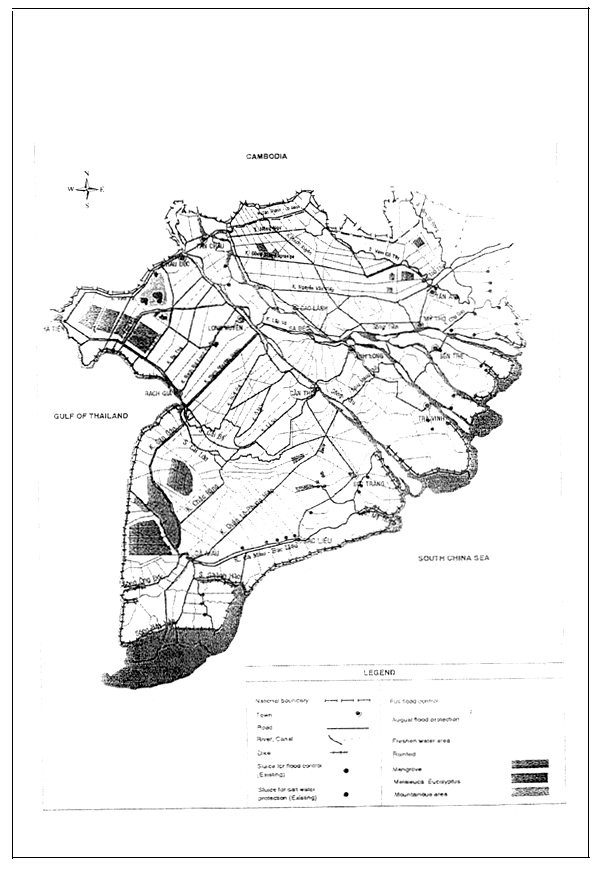
Boundary conditions used in the model for analysing the effects of the above flood control alternatives are the upstream discharge data of the 1961 flood (as flood condition for design), tidal data in 1994 (as unfavorable drainage conditions) and 10% probability of rainfall.
In two cases of flooding (with and without flood control alternatives), comparisons of the model outputs showed that:
In shallow flooded areas, full flood controls can be implemented in combination with irrigation, drainage, acidity leaching, sediment trapping, etc., to accelerate development.
In the Plain of Reeds, there are no significant changes in water level and discharge.
In the Long Xuyen Quadrangle, floodwaters with poor sediment flowing into the central portion of the Long Xuyen Quadrangle will be reduced from 14.3 billion m3 to 2.7 billion m3 while water with high sediment from the Bassac River will rise from 7.7 billion m3 to 15.1 billion m3. Water level in the central part of the Long Xuyen Quadrangle will be reduced 0.20 to 0.35 m.
Conclusions and recommendations
Annually, an area of 1.2 million to 1.8 million hectares in the Mekong Delta is flooded from 2 to 6 months. Flood water causes severe damage in terms of the loss of human life, production and infrastructure. Therefore, flood control planning is urgent in the Mekong Delta.
From studies carried out in recent years, it can be concluded that full flood control in shallow flooded areas do not cause significant change in water flow regimes and brings high economic returns. Diverting floodwater to the Gulf of Thailand cannot entirely solve the problem, but flooding timing and duration can be controlled to ensure agricultural production. During 1998– 2000, flood control activities will focus on protection for population centers along canals and roads. Key roads will be constructed and all flood water outlets will be enlarged. Small scale experimental cases with full flood control will be established to study alternatives in construction, management and operation.
Short-term flood control planning has been studied in combination with irrigation and drainage planning. However, several issues are still in question. Flooding in the Mekong Delta has both advantages and disadvantages. How can flood control planning make full use of the advantages and limit disadvantages? Full protection is the desired goal, but it may lead to some negative effects, for example: major changes in water levels and flow regimes in the whole Mekong Delta, hindering sediment trapping, acidity leaching, and reducing fish production. Therefore, close cooperation between riparian countries through the Mekong River Commission is necessary in flood control planning.
Mathematical models have now been used to compute various alternatives for short-term flood control in the Mekong Delta. In the next stages, effort will be made to improve models as essential tools in flood control planning and forecasting. A monitoring network is necessary to observe changes in flow regimes and to provide early identification of negative effects to the environment for studying mitigation measures. In the coming years, the pursuit of long-term flood control planning is necessary for a comprehensive solution to flood control and drainage challanges in the whole Mekong Delta.
![]()
![]()
![]()