![]()
![]()
![]()
This preliminary phase of the project describing the current water resource status in the Lesotho lowlands has been documented in a separate report (Tilquin & Maseatile, 1994). Major findings are summarized in this chapter.
Little information on dam work description was available from the Soil and Water Conservation Office mostly involved in the large dam construction programme undertaken during the 1950s and 1960s. A field survey, a topographic map review and indigenous knowledge provided the best supports to the inventory and classification of the Lesotho Lowlands reservoirs.
Field and topographic map surveys identified a total of 590 reservoirs in the Lesotho lowlands. Data on parameters describing these reservoirs, ranging from physical (depth, volume, location…) to socio-economic data (dam use, control, access…), were collected and loaded into a computerized database.
The 590 reservoirs include:
Furthermore, 66 of the reservoirs found were not on 1975 maps. Most of them are smaller than 3ha.
Finally, considering that some reservoirs built after 1975 have not been detected yet, and that inaccessible floodplains mentioned above are not yet silted up, the number of functional reservoirs was estimated at around 400.
Classification by surface area divides the reservoirs into four major size classes with sub-groups based on volume (Table 5.1.). The report by Tilquin & Maseatile (1994) shows that volume is another measurable data to order reservoirs in different classes which take into consideration the rate of siltation. The classes Ib and IIb include reservoirs silted at 80% or more. All reservoirs of class IIIb have an average depth below 1m and most of them too are largely silted.
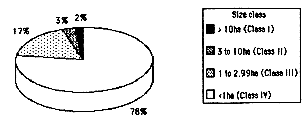
All reservoirs in the Lesotho lowlands are smaller than 100ha. They fall into the “minor category” of reservoirs adapted for the African context (Bernaseck, 1984).
Reservoirs greater than 10ha (class I) represent 2% of the SWBs. They include only four reservoirs lightly and moderately silted (Figure 5.1.).
| RESERVOIR SIZE CLASS | NUMBER OF RESERVOIRS (% of the total) | SURFACE AREA (ha) (% of the total) | ||
| DESCRIPTION | SURFACE AREA RANGE (S) | VOLUME RANGE (V) | ||
| CLASS la Large reservoirs | V>500,000m3 | 4 (1%) | 147 (35%) | |
| S<10ha | V<500,000m3 | |||
| CLASS Ib Large & silted reservoirs | 3 (1%) | 63 (15%) | ||
| CLASS IIa Medium reservoirs | 50–500,000m3 | 5(1%) | 25(6%) | |
| 3≤S≤10ha | ||||
| CLASS IIb Medium & silted reservoirs | V<50,000m3 | |||
| 8 (2%) | 40(9%) | |||
| CLASS IIIa Small reservoirs | 15–50,000m3 | 29 (8%) | 46 (11%) | |
| 1≤S<2.99ha | ||||
| CLASS IIIb Small & silted reservoirs | ||||
| V<15,000m3 | 34(9%) | 49 (12%) | ||
| CLASS IV Ponds | S<1ha | V<15,000m3 | 286(78%) | 54 (13%) |
| TOTAL | 369 (100%) | 424 (100%) | ||
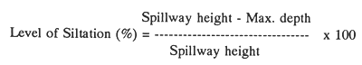
For example, 60% level of siltation means that the maximum depth of a reservoir has been reduced from 5 to 2m.
A reservoir is estimated as being lightly or moderately silted if the level of siltation is under 80%, severely silted when the level is between 80 and 94%; and silted up when it is 95% or more.
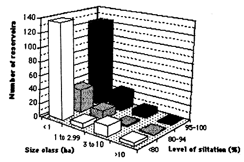
More than half (56%) of the reservoirs visited (572) were severely or completely silted. 80% of the reservoirs found in this situation were reservoirs smaller than 1ha (Figure 5.2.). These reservoirs were not considered for any further SWB activities.
Most of the reservoirs smaller than 3ha are affected by soil erosion. A further parameter, level of siltation, was therefore computed as follows (Tilquin & Maseatile, 1994):
Figure 5.2. Level of siltation of reservoirs by size class (Tilquin & Maseatile, 1994).
Sixteen reservoirs were selected to test and demonstrate small-scale fisheries and aquaculture management options. This selection was based on their morphometric profile, location to urban centre, and original uses. The four categories of reservoirs which are interesting for fish production are the classes Ia, IIa, IIIa, and some dams that belong to class IV.
Hence, four reservoirs in each of these classes were selected, including all but one reservoir from the tiny classes Ia and IIa, four reservoirs from the classes IIIa and four reservoirs of about 1ha at the limit between the classes IIIa and IV. Most class IV reservoirs are smaller than 0.8 hectare and could not been selected because there are too shallow to be assessed with gillnets (Chapter.6).
Appendix 1 provides the main information gathered on these 16 selected reservoirs.
![]()
![]()
![]()