![]()
![]()
![]()
LUAPULA PROVINCE
1. ECOLOGICAL
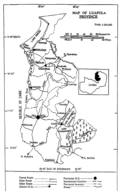
Luapula Province is located between latitudes 8 and 12.4 south and longitudes 28.5 and 30 . It borders Northern Province to the east and Zaire to the west, north and south. The total area is 50,600 km2 distributed as follows :-
TABLE 1 - Land Use Distribution In Luapula
| USE | KM2 |
Crop and fallow land | 11,600 |
Unused woodland and hills | 22,900 |
Lakes and swamps | 13,300 |
National Parks | 1,400 |
Forest States | 1,400 |
TOTAL | 50,600 |
The Province has three defined topographical features: The Luapula River Valley, the Plateau and the Bangweulu Lake and Swamp System (Map 1).
The Plateau has an altitude of 1,200 to 1,500 metres, with the highest point located in Kawambwa (1,500m). The valley has an altitude of 900 to 1,000 metres.
One of the main characteristics of Luapula is the abundance of underground and surface water consisting of numerous lakes, swamps, rivers, streams and dambos.
The soils are rich in iron and consist of sandy loam and loamy sand. Red brown soils derived from laterite are present in patches in Mansa, Kawambwe and Mwense plateau. Humic soils, rich in organic matter, are found in dambos. The pH for most soils is between 3.7 and 4.3. This is due to erosion caused by high rainfall which goes with a long rainy season. (Department of Agriculture, in Gould, n.d.:3).
The vegetation consists of miombo forest and grassland dominated by hyparrhenia. In the dambos the vegetation is of low growth grasses and other species, with a sporadic presence of a dambo forest known as “mushitu”.
The weather is mild with a dry season between April and November and a wet season between November and April. The rainy season starts earlier and finishes later in the highest part of the plateau. (Table 2).
TABLE 2 - Rainfall, Temperature And Evapotranspiration In Luapula (Department Of Agriculture, Mansa)
| MONTH | RAINFALL (mm) | TEMPERATURE (°C) | EVAPOTRANSPIRATION | |||||||||
| KAWAMBWA | MANSA | SAMFYA | ||||||||||
| KAWAMBWA | MANSA | SAMFYA | MAX. | MIN. | MAX. | MIN. | MAX. | MIN. | KAWAMBWA | MANSA | SAMFYA | |
| J | 221 | 230 | 276 | 30 | 15 | 28 | 17 | 25.1 | 14 | 133 | 163 | 148 |
| F | 197 | 208 | 281 | 30 | 14.7 | 29.5 | 18 | 27 | 18 | 128 | 156 | 150 |
| M | 267 | 211 | 321 | 30 | 14.5 | 29.5 | 18 | 25.4 | 17.6 | 131 | 143 | 165 |
| A | 139 | 66 | 106 | 28.5 | 13 | 29.4 | 18.5 | 26 | 17.3 | 137 | 144 | 167 |
| M | 19 | 4 | 6 | 27.5 | 11.6 | 25.3 | 11.5 | 25.5 | 15.3 | 158 | 174 | 164 |
| J | 0 | 0 | 0 | 29.0 | 10.5 | 26.4 | 85 | 20.5 | 10.9 | 146 | 167 | 138 |
| J | 0 | 0 | 0 | 28.2 | 8.5 | 28.3 | 8 | 20.1 | 11.8 | 156 | 169 | 158 |
| A | 1 | 0 | 0 | 30.7 | 10.5 | 37.9 | 8 | 25.8 | 16.9 | 195 | 202 | 186 |
| S | 15 | 4 | 1 | 32.2 | 12.2 | 30.6 | 11 | 27.1 | 15.7 | 206 | 239 | 221 |
| O | 85 | 28 | 20 | 32.6 | 14.5 | 31.6 | 11 | 28.7 | 16.7 | 197 | 244 | 231 |
| N | 199 | 168 | 150 | 31.4 | 14.5 | 28.1 | 17 | 22.5 | 18.1 | 132 | 189 | 215 |
| D | 262 | 232 | 324 | 31.5 | 14.6 | 28.0 | 16 | 24.3 | 19.6 | 125 | 157 | 173 |
| TOTAL | 1406 | 1156 | 1485 | 1844 | 2147 | 2116 | ||||||
2. POLITICAL DIVISION
The Province is divided into five districts: Mansa, Samfya, Mwense, Kawambwa and Nchelenge. Each district is divided into 20 wards, headed by a ward chairman. A traditional structure of Chiefs and Headmen exists alongside with, and interdependent of, the formal administrative structure. Although the traditional structure has lost some of its importance it still wields considerable influence.
3. ROADS
The capitals of the districts are connected with Mansa by 450 km of tarred road. A network of gravel roads connects important places with the district and provincial capitals. The province is also connected with Northern, Central and Copperbelt Provinces.
4. POPULATION
According to the 1980 census, Luapula has a total population of 412.998%. Population is predominantly rural, with only 13% of the inhabitants living in urban centres.
Table 3 : Population and population density by district
DISTRICT | TOTAL | MALES | FEMALES | DENSITY |
Kawambwa | 61,005 | 29,060 | 31,945 | 6.8 |
Mansa | 110,100 | 53,617 | 56,483 | 6.9 |
Mwense | 64,220 | 30,356 | 33,864 | 9.8 |
Nchelenge | 76,319 | 36,451 | 39,868 | 10.0 |
Samfya | 101,154 | 47,517 | 53,637 | 9.7 |
TOTAL | 412,798 | 197,001 | 215,777 | 43.2 |
Source: Republic of Zambia, CSO, 1980 Census of Population and Housing
The fishing districts of Mchelenge, Mwense and Samfya have higher population densities than the more agrarian districts of Mansa and Kawambwe (Table 3).
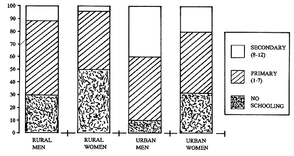
Two traits are clear regarding the distribution of population by sex and age; (i) the scarcity of male labour: there are 77 men to 100 women in the productive age group; (ii) the dependency ratio, i.e., the relation of productive to non-productive inhabitants (56% of the population is under 14 and over 60). (Figure 1).
The medium size of a Luapula household is 4.2 (Central Statistical Office). Households vary in size from single individuals to extended families of 10 or more. A network of dependence and reciprocity connects the households to one another. The single-member households include young bachelors often sharing resources with their parental home and old women living off the support of their children (Gould 32). According to the 1980 census, 36.2% of all households in Luapula are headed by women.
5. EDUCATION
The level of education is presented in Table 4.
Table 4
| LEVEL OF EDUCATION | NUMBER OF ADULTS | POPULATION OF ADULTS |
| No schooling | 79,735 | 38.3% |
| Primary (grades 1 to 7) | 106,504 | 51.2% |
| Secondary (grades 8 to 12) | 21,654 | 10.4% |
| Tertiary (University, etc) | 73 | 0.1% |
Source : 1980 Census of Population and Housing, p. 348
There are great differences between the levels of education of men and women in the urban and rural populations (see Figure 1).
Figure 1 - Level of Education By Sex & Residence In Luapula 1980
Luapula has 294 primary and 11 secondary schools (FNDP, 1989, 644). The primary enrolment was 93% (of the 7 to 14 years old) in the period 1975 to 1983 (Gould, 47). Many rural schools are understaffed, however, and conditions in the schools have been deteriorating because of lack of funds for maintenance, repairs and teaching materials. The number of dropouts between Grade One and Grade Seven is 1/3 of the population on enrolment (FNDP, 1989, 645). Most schools have an agricultural unit.
6. SOCIAL ORGANIZATION
The Luapula region is inhabited by nine more or less discrete ethnic groups. The largest are the Aushi who populate most of Mansa district. The Ng'umbo are found in Samfya North, the Kabende in Samfya and Mwense and the Bwile and Shila in Nchelenge. The Unga reside in and along the Bangweulu swamps in Samfya South (Gould, n.d.; 18). Imai (1985:22) also mentions the Batwa people living in the Bangweulu swamps who specialize in swamp fishing. There is a close correspondence between ARPT farming system zones and areas occupied by different ethnic groups. (TRD1 Unga, TRD2 Kabende, TRD3 Ng'umbo, TRD4 Aushi, TRD5 Lunda, TRD6 Chisinga, TRD7 Shila, Bwile).
With the exception of the Lunda, all ethnic groups have a matrilineal system of kinship.
Marriage has traditionally been matrilineal, meaning that the men move to their wives' village. The potential heirs live in different places. This inheritance system may influence the consolidation of property within households. The practice of virilocal residence (the wife moves to the husband's village upon marriage) unites male relatives. As they inherit each others' property they are also interested in consolidation of the property of each individual household.
The social organization is traditionally based on the distribution of resources. Within the kinship system there exist mutual obligations to exchange goods and services. Scarce resources are distributed within the lineage.
Profound economic changes have taken place during the past generation and traditional social structures have been affected. Social differences are getting more pronounced.
7. FISHERIES
Thirty-five to 40 per cent of the total Zambian fish production of 53,000 tonnes/year is caught in Luapula Province. Fishing is one of the most important economic activities of Luapula. It is estimated that 150,000 people are directly dependent on fishing and half of the population is said to be somehow involved in fishing and the fish trade (Gould, n.d.).
The main fishing areas are the Bangweulu System (lakes plus adjoining swamps), Lake Mweru and the Luapula River which connects the Bangweulu System with Lake Mweru. A major part of the Province population is concentrated along these water bodies. There are no industrial fishing companies.
Table 5 - Distribution of Fishermen and Their Equipment
| NUMBER OF : | LAKE MWERU | BANGWEULU SYSTEM |
Fishermen | 7,675 | 10,146 |
Canoes | 3,914 | 5,305 |
Plank boats | 2,639 | 42 |
Fibreglass boats | 82 | 72 |
Outboard engines | 212 | 54 |
Source : Draft SNV Kashikishi Iceplant Proposal 1989
Fishing for sale is done mostly by men. The most common fishing gear is the gill net. Import restrictions and old machinery make it difficult for Zambia's only net factory, Nkwazi Manufacturing Company in Kafue, to meet the demand for nets. Nets made in China and Taiwan are brought into Zambia through Tanzania and Zaire.
The average annual catches from the main Luapula fishing grounds are given in Table 6.
Table 6 - Average Annual Catch (Tonnes)
| PERIOD | LAKE MWERU | BANGWEULU SYSTEM | TOTAL |
| 1975–1980 | 8,905 | 9,655 | 18,560 |
| 1982–1988 | 8,833 | 11,910 | 20,743 |
Source : Statistical Yearbook for Luapula Province, 1987, SNV, Draft Proposal Kashikishi Iceplant, 1989
Note : For computing the average annual catches 1981 has not been included because of the exceptionally low figures for this year caused by a fishing ban during a cholera outbreak in the area. Data on catches before 1975 have not been included because two very different sets of data were found for the period.
The above statistics do not include the unregistered trade of fish to Zaire, which is estimated to be 30% of the total Zambian catch (SNV, 1989). Assuming that this fish mainly originates from Luapula, approximately 15,000 tonnes have to be added to the average Luapula annual fish production.
Some fish species have become rare (Oreochromis macrochir) or even extinct (Luapula Salmon, Laveo altivelis: Gould n.d.). To catch the same quantity as 30 years ago fishermen have to use a greater number of gill nets or other types of gears and spend more time fishing. Chiclidae, Mormyridae, Siluridae and some small Cyprinidae species compose most of the catch.
To protect the stocks from over-fishing, several laws and regulations have been issued; a minimum mesh of 51mm for gill nets; a closed season for commercial fishing from December 1st until February 28th; prohibition of the use of beach seines; prohibition of the use of poison to catch fish; prohibition of the technique of scaring fish in the direction of the gill nets.
Fresh fish is found only in the immediate environment of the fish landing centres and sometimes in the district capitals. Most fish is processed and transported outside the Province. Besides the unofficial trade with Zaire, approximately 13,000 tonnes of fish are sold in the Copperbelt and Lusaka annually, mostly in smoked or dried form (Provincial Planning Unit, 1985). Most fish for the Zairian market is salted.
The fish resources of Zambia are managed by the Department of Fisheries (DoF), which has the task of developing, controlling and regulating fishing activities and conserving the fish stocks in order to optimize the country's fish production. The Department has four divisions :-
The Research Division, which carries out studies on limnology, ecology, species composition and distribution and gear and development.
The Extension and Development Division, which is responsible for disseminating findings and recommendations that emanate from the Research Division. This Division deals with handling and processing fish, gear construction, and development of methods for exploiting underexploited species. The Division also collects market data, undertakes catch assessment surveys and enforces fisheries legislation.
The Training Division, which is responsible for training the fish communities on net making and mending, fish handling and processing, engine maintenance, co-operatives, fisheries regulations and conservation.
The Fish Culture Division, which is responsible for fish culture activities, including the import of exotic species and export of aquarium fish.
The DoF in Luapula is headed by the Provincial Fisheries Development Officer, who is based in Mansa. He is assisted by two Research Officers and two Fisheries Development Officers who are based at the branch offices in Samfya and Nchelenge. There is one Fisheries Training Instructor who is based in Nchelenge. The Fish Culturist is based in Mansa. The officers are assisted by a few fish scouts concerned with capture fisheries and four scouts concerned with fish culture.
The two branch offices in Samfya and Nchelenge have access to one vehicle each. The Samfya branch has two motorized boats and 17 scouts, one Research Officer and one District Fisheries Development Officer. The main tasks are data collection for stock assessment, limnological research, catch assessment, monitoring and levies on fish trade, enforcement of fisheries regulations and training of fisherfolk in fish processing.
The scouts have been trained for 6 to 12 months at Kasaka Fisheries School near Kafue in statistics, fish conservation, boat building, fish gears, fishing technology, boat mechanics, extension and fish farming.
8. AGRICULTURE
Chitemene, a slash and burn technique of shifting cultivation, has been the traditional form of agriculture. The main staple food used to be finger millet, but now cassava has taken over this role. (Mansfield, 1975). It was believed for many years that Luapula lacked agricultural potential, because of the acid character of the soils. Only recently has an agriculture development effort been mounted. A strong maize production campaign has resulted in a production increase of 9,279,270 tonnes in 12 years. (Tables 7 and 8).
The main crops are cassava, maize, groundnuts and beans. Lintco is also promoting soyabeans, coffee and cotton. Other minor crops are sunflower, bambarranuts, different kinds of vegetables, sweet potatoes and Irish potatoes. Tea is produced at the Kawambwa District by the Kawambwa Tea Estates.
The technological level is low, dominated by the use of hoes. However, an effort has been made to introduce ox-drawn power. One of the problems in implementing the animal traction programme is that animal rearing is not an important activity in the province.
Table 7 - Maize Production And Sales 1973–86 (90 Kgs/Bags)
| YEAR | PLANTED HECTARAGE | PRODUCTION (BAGS) | SALES TO MARKETING ORGANIZATION (BAGS) |
| 1973/74 | 1,241 | 23,927 | 15,518 |
| 1974/75 | 1,537 | 48,157 | 13,207 |
| 1975/76 | 1,293 | 33,882 | 26,637 |
| 1976/77 | 1,557 | 41,256 | 33,731 |
| 1977/78 | 1,826 | 40,534 | 33,797 |
| 1978/79 | 1,664 | 27,870 | 19,318 |
| 1979/80 | 1,936 | 29,379 | 19,164 |
| 1980/81 | 1,874 | 40,211 | 29,630 |
| 1981/82 | 2,882 | 65,516 | 50,822 |
| 1982/83 | 3,366 | 63,250 | 40,155 |
| 1983/84 | 4,500 | 95,000 | 71,091 |
| 1984/85 | 5,400 | 109,300 | 58,720 |
| 1985/86 | 5,740 | 127,030 | 95,940 |
Source : Annual Report, Provincial Agriculture Office, Luapula Province, 1986.
Cattle are found mostly in Samfya and Mansa, with a higher concentration in Lubwa (Samfya District), but the number is not significant. Other livestock are goats and sheep. Poultry is found in every household.
The Agriculture Department has a complete extension service network with agents in every Ward. It also has five farm training centres, a farm institute and five ox-training centres.
Several organizations are supporting agriculture production: IRDP-LP, FINNIDA, IFAD, SIDA and the Catholic Church.
9. INDUSTRY
The only industrial enterprises in Luapula are a battery factory in Mansa, tea processing at the Kawambwa Tea Estate, grain mills in Mansa and Nchelenge and a brewery. (Gould, n.d.: 53).
Table 8 - Maize Area, Yield, Production, Marketing and Value (1982 – 1986) 90Kgs/Bag
| AREA (HA) | YIELD (BAGS/HA) | PRODUCTION (BAGS) | RETAINED (BAGS) | MARKETED (BAGS) | VALUE (K'OOO) | ||
|---|---|---|---|---|---|---|---|
| Zambia | 1986 | 588 490 | 21 | 12 350 660 | 3 848 540 | 8 502 120 | - |
| 1985 | 581 900 | 21 | 12 470 800 | 5 401 163 | 7 069 837 | 200 212 | |
| 1984 | 506 500 | 19 | 9 686 000 | 3 418 363 | 6 347 637 | 153 557 | |
| 1983 | 546 700 | 19 | 10 392 000 | 4 490 176 | 5 901 824 | 108 003 | |
| 1982 | 454 500 | 18 | 8 336 000 | 2 630 422 | 5 705 578 | 91 289 | |
| Luapula | 1986 | 5 740 | 22 | 27 030 | 31 090 | 95 940 | - |
| 1985 | 5 400 | 20 | 109 300 | 50 580 | 58 720 | 1 663 | |
| 1984 | 4 500 | 21 | 95 000 | 23 909 | 71 091 | 1 742 | |
| 1983 | 3 400 | 21 | 73 000 | 32 845 | 40 155 | 735 | |
| 1982 | 2 900 | 21 | 60 000 | 9 787 | 50 213 | 803 | |
Source : Republic of Zambia, MAWD, Planning Division, Statistics Section, Quarterly Agricultural Statistics Bulletin, October-December 1985
Table 8 - Maize Area, Yield, Production, Marketing and Value (1982 – 1986) 90Kgs/Bag
| AREA (HA) | YIELD (BAGS/HA) | PRODUCTION BAGS) | RETAINED (BAGS) | MARKETED (BAGS) | VALUE (K'OOO) | ||
|---|---|---|---|---|---|---|---|
| Zambia | 1986 | 588 490 | 21 | 12 350 660 | 3 848 540 | 8 502 120 | - |
| 1985 | 581 900 | 21 | 12 470 800 | 5 401 163 | 7 069 837 | 200 212 | |
| 1984 | 506 500 | 19 | 9 686 000 | 3 418 363 | 6 347 637 | 153 557 | |
| 1983 | 546 700 | 19 | 10 392 000 | 4 490 176 | 5 901 824 | 108 003 | |
| 1982 | 454 500 | 18 | 8 336 000 | 2 630 422 | 5 705 578 | 91 289 | |
| Luapula | 1986 | 5 740 | 22 | 127 030 | 31 090 | 95 940 | - |
| 1985 | 5 400 | 20 | 109 300 | 50 580 | 58 720 | 1 663 | |
| 1984 | 4 500 | 21 | 95 000 | 23 909 | 71 091 | 1 742 | |
| 1983 | 3 400 | 21 | 73 000 | 32 845 | 40 155 | 735 | |
| 1982 | 2 900 | 21 | 60 000 | 9 787 | 50 213 | 803 | |
Source : Republic of Zambia, MAWD, Planning Division, Statistics Section, Quarterly Agricultural Statistics Bulletin, October-December 1985
![]()
![]()
![]()