![]()
![]()
![]()
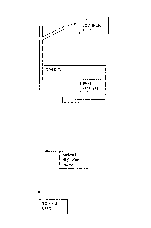
LOCATION
Province: Jodhpur
District: Jodhpur
Latitude (degrees and minutes): 24°40'N
Longitude (degrees and minutes): 71°15'E
Altitude (m above sea level): 224
Managing office/institution: Indian Council of Forestry Research and Education
Owner: do
User(s): do
Distance to nearest office responsible for management of the trial (km): 3 km
Distance to nearest villages/towns (km): Within city limits
Number of inhabitants in the nearest villages/towns:
Type of area (e.g. research station, managed forest, etc.): Experimental field
CLIMATE
Nearest weather station:
Name of the station: Arid Forest Research Institute, Jodhpur
Latitude (degrees and minutes): 24º40'N
Longitude (degrees and minutes): 71º15'E
Altitude (m a.s.l.): 224 m
Climatic data1 |
Jan. |
Feb. |
Mar. |
Apr. |
May |
June |
July |
Aug. |
Sep. |
Oct. |
Nov. |
Dec. |
Year |
Rainfall (mm) |
39 |
53 |
37 |
28 |
93 |
30.9 |
97.5 |
114.3 |
44.9 |
4.8 |
1.1 |
1.8 |
325.3 |
Temp. mean (_C) |
17 |
19.5 |
25.2 |
30.3 |
34.4 |
34.3 |
31.2 |
29.2 |
29.4 |
27.6 |
22.6 |
18.7 |
27.1 |
Temp. mean max.2 (_C) |
24.6 |
27.9 |
33.3 |
38.3 |
41.6 |
40.1 |
35.7 |
33.2 |
34.7 |
35.7 |
31.4 |
26.7 |
33.6 |
Temp. mean min.3 (_C) |
9.5 |
12 |
17.1 |
22.4 |
27.3 |
28.5 |
26.8 |
25.2 |
24.1 |
19.6 |
13.9 |
10.7 |
20.65 |
Evapotranspiration4 (mm) |
104.6 |
141.7 |
278.8 |
341.1 |
403 |
322.7 |
231.6 |
156.5 |
170.8 |
170.2 |
128.8 |
107.8 |
- |
1 Period of observations:.........(specify years) 2 Average of daily maximum temperatures
3 Average of daily minimum temperatures 4 Potential evapotranspiration (ETP) - Penman's formula
Rainy season:
Number/type of seasons: |
one |
two |
even/irregular |
Period(s): July to September (specify months)
Length of rainy season:
No. of intermediate days: (pre- and posthumid period of the growing season)
No. of wet days: (growing season)
Number of dry months per year (< 50 mm rain/month): 10 months
Frost (number of days/year): 40 to 50 days
Prevailing winds (direction, period, speed):
TOPOGRAPHY (slope) of trial site
x |
Flat/gentle (0-8%) |
Intermediate (9-30%) |
Steep (>30%) |
GENERAL SOIL DESCRIPTION |
Soil texture |
Soil depth |
Soil drainage/ Waterlogging |
Gravel content, topsoil | ||||
1. Light/sandy |
X |
1. Shallow (< 50 cm) |
1. Well drained |
x |
1. None (< 15 %) |
x | |
2. Medium/loamy |
2. Deep (50-100 cm) |
x |
2. Seasonal |
2. Gravelly (15-35 %) |
|||
3. Heavy/clayey |
3. Very deep (> 100 cm) |
3. Permanent |
3. Stony (> 35 %) |
||||
Organic matter content |
Reaction (pH) |
Soil salinity |
Groundwater | ||||
1. Poor (< 2 % DM) |
x |
1. Acid (pH < 6.5) |
1. None |
1. Shallow (< 50 cm) |
|||
2. Medium (2-5 % DM) |
2. Neutral (6.5-7.5) |
2. Moderate |
x |
2. Deep (50 - 150 cm) |
| ||
3. Rich (> 5 %) |
3. Alkaline (pH> 7.5) |
x |
3. High |
3. Very deep (>150 cm) |
x | ||
Specify soil unit, soil association and phases (subdivisions of soil units) according to the Soil map of the world (FAO-Unesco 1971-1979), if known:
VEGETATION
Natural (original) vegetation type: Arid vegetation; Prosopis - Capparis - Zizyphus type
Dominant natural (original) genera/species: Prosopis cineraria, Tecomella undulata, Acacia senegal, Zizyphus numularia, Capparis decidua, Calotropis procera, Balanites aegyptiaca, Indigofera argentea
Land use history: Used for rainfed cultivation and as a grassing ground for the cattles
Apparent major problems of site (pests, diseases, etc):.Termite attack and grassing by cattles and wild animals
Economic data, viz. farm gate prices for fodder, fuel wood, small size timber,
extractives, and other minor produce:
TRIAL ESTABLISHMENT AND MANAGEMENT
Year and month of establishment: July 1996
Area (ha): 2 ha
Initial spacing (m x m): 3 x 3 m
Soil preparation (time, method/intensity): cleaning of the field, marking and digging of pits
Planting method(age of seedlings, type): one-year-old polythene bag raised seedlings were transplanted
Beating up (time, %):
Irrigation (time, amount): 15 l of water was provided to each plant in a fortnight
Fertilization (time, type, amount): Approximately 1 kg of farm yard manure per pit was applied at the
time of planting
Weeding (time, intensity): once in a month
Thinning (time, intensity): No thinning was done
Firelines: No fire line was provided
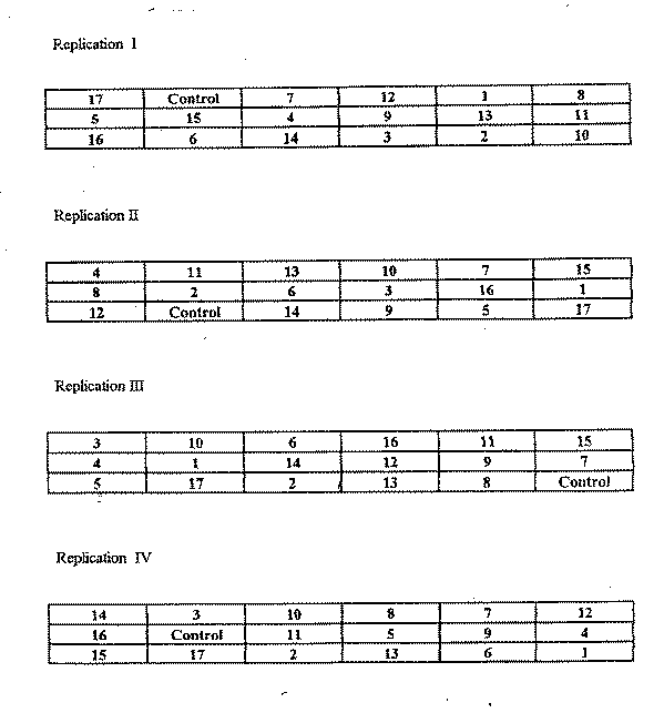
TRIAL DESIGN
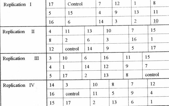
Statistical design: Randomized complete block design
No. of replications (blocks): 4 replications
No. of treatments (provenances): 18
Plot size (No. of trees in plot): 25 trees per plot (16 for Vientiane)
Demarcation (blocks, plots):
PROVENANCES TESTED
Marked provenances have been included in the trial:
Nazir Hat (01/BGD/Naz) |
Annur (06/IND/Ann) |
Vientiane (11/LAO/Vie) |
Tibbi Laran (16/PAK/Tib) |
Ban Bo (21/THA/Bo) |
Chapai Nawabganj (02/BGD/Cha) |
Ghaati Subramanya (07/IND/Gha) |
Yezin (12/MYA/Yez) |
Multan (17/PAK/Mul) |
Doi Tao (22/THA/Doi) |
Mandore (03/IND/Man) |
Sagar Chanatoria (08/IND/Sag) |
Myene (13/MYA/Mye) |
Kuliyapitiya (18/SRL/Kul) |
Sunyani (23/GHA/Sun) |
Chitradurga (04/IND/Chi) |
Balharshah (09/IND/Bal) |
Lamahi (14/NEP/Lam) |
Tung Luang (19/THA/Thu) |
Bandia (24/SEN/Ban) |
Allahabad (05/IND/All) |
Ramannaguda (10/IND/Ram) |
Geta (15/NEP/Get) |
Ban Nong Rong 1 (20/THA/Non) |
Chamwino (25/TAN/Cha) |
Names of any local provenances included in the trial: Kulapachra and Kalyani
PROTECTION STATUS:
Status (describe any disturbances/damages): Browsing by blue bull
Guarding (permanent, regular, none): During day time a watchman is provided and the area is fenced
Legend:
Local No.: |
International No.: |
Local No.: |
International No.: |
Local No.: |
International No.: |
1 |
19/THA/Thu |
7 |
15/NEP/Get |
13 |
08/IND/Sag |
2 |
20/THA/Non |
8 |
25/TAN/Cha |
14 |
06/IND/Ann |
3 |
22/THA/Doi |
9 |
10/IND/Ram |
15 |
03/IND/Man |
4 |
11/LAO/Vie |
10 |
Kulapachra (India) |
16 |
05/IND/All |
5 |
12/MYA/Yes |
11 |
Kalyani (India) |
17 |
07/IND/Gha |
6 |
14/NEP/Lam |
12 |
09/IND/Bal |
18 |
Control (local provenance) |
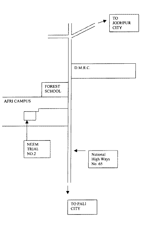
LOCATION
Province: Jodhpur
District: Jodhpur
Latitude (degrees and minutes): 24°40'N
Longitude (degrees and minutes): 71°15'E
Altitude (m above sea level):
Managing office/institution: Indian Council of Forestry Research and Education
Owner: do
User(s): do
Distance to nearest office responsible for management of the trial (km): 3 km
Distance to nearest villages/towns (km): Within city limits
Number of inhabitants in the nearest villages/towns:
Type of area (e.g. research station, managed forest, etc.): Experimental field
CLIMATE
Nearest weather station:
Name of the station: Arid Forest Research Institute, Jodhpur
Latitude (degrees and minutes): 24º40'N
Longitude (degrees and minutes): 71º15'E
Altitude (m a.s.l.):
Climatic data1 |
Jan. |
Feb. |
Mar. |
Apr. |
May |
June |
July |
Aug. |
Sep. |
Oct. |
Nov. |
Dec. |
Year |
Rainfall (mm) |
39 |
53 |
37 |
28 |
93 |
30.9 |
97.5 |
114.3 |
44.9 |
4.8 |
1.1 |
1.8 |
325.3 |
Temp. mean (_C) |
17 |
19.5 |
25.2 |
30.3 |
34.4 |
34.3 |
31.2 |
29.2 |
29.4 |
27.6 |
22.6 |
18.7 |
27.1 |
|
Temp. mean max.2 (_C) |
24.6 |
27.9 |
33.3 |
38.3 |
41.6 |
40.1 |
35.7 |
33.2 |
34.7 |
35.7 |
31.4 |
26.7 |
33.6 |
|
Temp. mean min.3 (_C) |
9.5 |
12 |
17.1 |
22.4 |
27.3 |
28.5 |
26.8 |
25.2 |
24.1 |
19.6 |
13.9 |
10.7 |
20.65 |
|
Evapotranspiration4 (mm) |
104.6 |
141.7 |
278.8 |
341.1 |
403 |
322.7 |
231.6 |
156.5 |
170.8 |
170.2 |
128.8 |
107.8 |
- |
1 Period of observations:.........(specify years) 2 Average of daily maximum temperatures
3 Average of daily minimum temperatures 4 Potential evapotranspiration (ETP) - Penman's formula
Rainy season:
|
Number/type of seasons: |
x |
one |
two |
even/irregular |
Period(s): (specify months)
Length of rainy season:
No. of intermediate days: July to September (pre- and posthumid period of the growing season)
No. of wet days: (growing season)
Number of dry months per year (< 50 mm rain/month): 10 months
Frost (number of days/year): 40 to 50 days
Prevailing winds (direction, period, speed):
TOPOGRAPHY (slope) of trial site
|
x |
Flat/gentle (0-8%) |
Intermediate (9-30%) |
Steep (>30%) |
|
GENERAL SOIL DESCRIPTION |
|
Soil texture |
Soil depth |
Soil drainage/ Waterlogging |
Gravel content, topsoil | ||||
|
1. Light/sandy |
X |
1. Shallow (< 50 cm) |
1. Well drained |
x |
1. None (< 15 %) |
x | |
|
2. Medium/loamy |
2. Deep (50-100 cm) |
x |
2. Seasonal |
2. Gravelly (15-35 %) |
|||
|
3. Heavy/clayey |
3. Very deep (> 100 cm) |
3. Permanent |
3. Stony (> 35 %) |
||||
|
Organic matter content |
Reaction (pH) |
Soil salinity |
Groundwater | ||||
|
1. Poor (< 2 % DM) |
x |
1. Acid (pH < 6.5) |
1. None |
1. Shallow (< 50 cm) |
|||
|
2. Medium (2-5 % DM) |
2. Neutral (6.5-7.5) |
2. Moderate |
x |
2. Deep (50 - 150 cm) |
|||
|
3. Rich (> 5 %) |
3. Alkaline (pH> 7.5) |
x |
3. High |
3. Very deep (>150 cm) |
x | ||
Specify soil unit, soil association and phases (subdivisions of soil units) according to the Soil map of the world (FAO-Unesco 1971-1979), if known:
VEGETATION
Natural (original) vegetation type: Arid vegetation; prosopis - Capparis - Zizyphus type
Dominant natural (original) genera/species: Prosopis cineraria, Tecomella undulata, Acacia senegal, Zizyphus numularia, Capparis decidua, Calotropis procera, Balanites aegyptiaca, Indigofera argentea
Land use history: Used for rainfed cultivation and as a grassing ground for the cattles
Apparent major problems of site (pests, diseases, etc):.Termite attack
Economic data, viz. farm gate prices for fodder, fuel wood, small size timber,
extractives, and other minor produce:
TRIAL ESTABLISHMENT AND MANAGEMENT
Year and month of establishment: August 1996
Area (ha): 0.5 ha
Initial spacing (m x m): 3 x 3 m
Soil preparation (time, method/intensity): cleaning of the field, marking and digging of pits
Planting method(age of seedlings, type): one-year-old polythene bag raised seedlings were transplanted
Beating up (time, %):
Irrigation (time, amount): 15 l of water was provided to each plant in a fortnight
Fertilization (time, type, amount): Approximately 1 kg of farm yard manure per pit was applied at the
time of planting
Weeding (time, intensity): once in a month
Thinning (time, intensity): No thinning was done
Firelines: No fire line was provided
TRIAL DESIGN
Statistical design: Randomized complete block design
No. of replications (blocks): 4 replications
No. of treatments (provenances): 5 provenances
Plot size (No. of trees in plot): 6 trees per plot
Demarcation (blocks, plots):
PROVENANCES TESTED
Marked provenances have been included in the trial:
|
Nazir Hat (01/BGD/Naz) |
Annur (06/IND/Ann) |
Vientiane (11/LAO/Vie) |
Tibbi Laran (16/PAK/Tib) |
Ban Bo (21/THA/Bo) |
|
Chapai Nawabganj (02/BGD/Cha) |
Ghaati Subramanya (07/IND/Gha) |
Yezin (12/MYA/Yez) |
Multan (17/PAK/Mul) |
Doi Tao (22/THA/Doi) |
|
Mandore (03/IND/Man) |
Sagar Chanatoria (08/IND/Sag) |
Myene (13/MYA/Mye) |
Kuliyapitiya (18/SRL/Kul) |
Sunyani (23/GHA/Sun) |
|
Chitradurga (04/IND/Chi) |
Balharshah (09/IND/Bal) |
Lamahi (14/NEP/Lam) |
Tung Luang (19/THA/Thu) |
Bandia (24/SEN/Ban) |
|
Allahabad (05/IND/All) |
Ramannaguda (10/IND/Ram) |
Geta (15/NEP/Get) |
Ban Nong Rong 1 (20/THA/Non) |
Chamwino (25/TAN/Cha) |
Names of any local provenances included in the trial:
PROTECTION STATUS:
Status (describe any disturbances/damages): Well protected and managed, damaged only due to frost
Guarding (permanent, regular, none): The trial is well protected and is within the Institute Campus
regular watch and ward is provided for 24 hours
Legend:
|
Local No.: |
International No.: |
Local No.: |
International No.: |
|
1 |
19/THA/Thu |
3 |
22/THA/Doi |
|
2 |
20/THA/Non |
4 |
11/LAO/Vie |
The trial was abandoned because of high mortality of seedlings in the initial stage.
LOCATION
Province: Jaipur
District: Jaipur
Latitude (degrees and minutes): 26°40'N
Longitude (degrees and minutes): 75°50'E
Altitude (m above sea level):
Managing office/institution: State Silviculturist, Rajasthan
Owner: Forest Department of Rajasthan
User(s): Forest Department of Rajasthan
Distance to nearest office responsible for management of the trial (km): 12 km
Distance to nearest villages/towns (km): 2 km
Number of inhabitants in the nearest villages/towns: 3000
Type of area (e.g. research station, managed forest, etc.): Experimental field - Research station
CLIMATE
Nearest weather station:
Name of the station: Jaipur
Latitude (degrees and minutes): 26º49'N
Longitude (degrees and minutes): 75º48'E
Altitude (m a.s.l.): 436 m
|
Climatic data1 |
Jan. |
Feb. |
Mar. |
Apr. |
May |
June |
July |
Aug. |
Sep. |
Oct. |
Nov. |
Dec. |
Year |
|
Rainfall (mm) |
11.2 |
9.0 |
5.9 |
3.6 |
9.9 |
51.3 |
182.1 |
180.7 |
85 |
9.9 |
1.9 |
10 |
556.4 |
|
Temp. mean (_C) |
15.4 |
18.1 |
23.2 |
28.8 |
33.2 |
33.3 |
29.9 |
28.1 |
28.1 |
20 |
20.5 |
17 |
25.1 |
|
Temp. mean max.2 (_C) |
22.4 |
25.4 |
30.9 |
36.5 |
40.6 |
39.2 |
34.1 |
33.2 |
33.2 |
24 |
24.0 |
24 |
31.7 |
|
Temp. mean min.3 (_C) |
8.3 |
10.7 |
15.5 |
21 |
25.8 |
27.3 |
25.6 |
23 |
18.3 |
12 |
12.0 |
9.1 |
18.4 |
|
Evapotranspiration4 (mm) |
1 Period of observations:.........(specify years) 2 Average of daily maximum temperatures
3 Average of daily minimum temperatures 4 Potential evapotranspiration (ETP) - Penman's formula
Rainy season:
|
Number/type of seasons: |
x |
one |
two |
even/irregular |
Period(s): July to September (specify months)
Length of rainy season:
No. of intermediate days: (pre- and posthumid period of the growing season)
No. of wet days: (growing season)
Number of dry months per year (< 50 mm rain/month): 8 months
Frost (number of days/year): 40 to 50 days
Prevailing winds (direction, period, speed):
TOPOGRAPHY (slope) of trial site
|
x |
Flat/gentle (0-8%) |
Intermediate (9-30%) |
Steep (>30%) |
|
GENERAL SOIL DESCRIPTION |
|
Soil texture |
Soil depth |
Soil drainage/ Waterlogging |
Gravel content, topsoil | ||||
|
1. Light/sandy |
1. Shallow (< 50 cm) |
1. Well drained |
x |
1. None (< 15 %) |
x | ||
|
2. Medium/loamy |
X |
2. Deep (50-100 cm) |
2. Seasonal |
2. Gravelly (15-35 %) |
|||
|
3. Heavy/clayey |
3. Very deep (> 100 cm) |
x |
3. Permanent |
3. Stony (> 35 %) |
|||
|
Organic matter content |
Reaction (pH) |
Soil salinity |
Groundwater | ||||
|
1. Poor (< 2 % DM) |
x |
1. Acid (pH < 6.5) |
1. None |
x |
1. Shallow (< 50 cm) |
||
|
2. Medium (2-5 % DM) |
2. Neutral (6.5-7.5) |
2. Moderate |
2. Deep (50 - 150 cm) |
||||
|
3. Rich (> 5 %) |
3. Alkaline (pH> 7.5) |
x |
3. High |
3. Very deep (>150 cm) |
x | ||
Specify soil unit, soil association and phases (subdivisions of soil units) according to the Soil map of the world (FAO-Unesco 1971-1979), if known:
VEGETATION
Natural (original) vegetation type: Acacia leucophloea - Prosopis cineraria - Acacia nilotica type
Dominant natural (original) genera/species: Acacia leucophloea, Prosopis cineraria, Acacia nilotica, Acacia
senegal, Azadirachta indica, Salvadora persia, Zizyphus mauritiana, Calotropis procera, Capparis decidua,
Zizyphus numularia
Land use history: Protected Forest
Apparent major problems of site (pests, diseases, etc):.
Economic data, viz. farm gate prices for fodder, fuel wood, small size timber,
extractives, and other minor produce:
TRIAL ESTABLISHMENT AND MANAGEMENT
Year and month of establishment: August 1996
Area (ha): 2 ha
Initial spacing (m x m): 3 x 3 m
Soil preparation (time, method/intensity): Clearing of land, marking and digging of pits
Planting method(age of seedlings, type): One-year-old Polythene bag raised seedlings were transplanted
Beating up (time, %):
Irrigation (time, amount): 15 l of water every week
Fertilization (time, type, amount): 1 kg of farm yard manure
Weeding (time, intensity): Once in a month
Thinning (time, intensity): No thinning
Firelines: No fire line
TRIAL DESIGN
Statistical design: Randomised complete block design
No. of replications (blocks): 4 replications
No. of treatments (provenances): 18
Plot size (No. of trees in plot): 25 trees (Vientiane 16 plants)
Demarcation (blocks, plots): Well demarcated
PROVENANCES TESTED
Marked provenances have been included in the trial:
|
Nazir Hat (01/BGD/Naz) |
Annur (06/IND/Ann) |
Vientiane (11/LAO/Vie) |
Tibbi Laran (16/PAK/Tib) |
Ban Bo (21/THA/Bo) |
|
Chapai Nawabganj (02/BGD/Cha) |
Ghaati Subramanya (07/IND/Gha) |
Yezin (12/MYA/Yez) |
Multan (17/PAK/Mul) |
Doi Tao (22/THA/Doi) |
|
Mandore (03/IND/Man) |
Sagar Chanatoria (08/IND/Sag) |
Myene (13/MYA/Mye) |
Kuliyapitiya (18/SRL/Kul) |
Sunyani (23/GHA/Sun) |
|
Chitradurga (04/IND/Chi) |
Balharshah (09/IND/Bal) |
Lamahi (14/NEP/Lam) |
Tung Luang (19/THA/Thu) |
Bandia (24/SEN/Ban) |
|
Allahabad (05/IND/All) |
Ramannaguda (10/IND/Ram) |
Geta (15/NEP/Get) |
Ban Nong Rong 1 (20/THA/Non) |
Chamwino (25/TAN/Cha) |
Names of any local provenances included in the trial: Jaipur, Kulapachra and Kalyani
PROTECTION STATUS:
Status (describe any disturbances/damages): Termite attack, frost damage
Guarding (permanent, regular, none): Well protected with 24 hour watch and ward
Site map missing
Trial design map missing
LOCATION
Province: Jabalpur
District:
Latitude (degrees and minutes): 23°50'N
Longitude (degrees and minutes): 78°44'E
Altitude (m above sea level):
Managing office/institution: Indian Council of Forestry Research and Education
Owner: do
User(s): do
Distance to nearest office responsible for management of the trial (km):
Distance to nearest villages/towns (km):
Number of inhabitants in the nearest villages/towns:
Type of area (e.g. research station, managed forest, etc.):
CLIMATE
Nearest weather station:
Name of the station:
Latitude (degrees and minutes):
Longitude (degrees and minutes):
Altitude (m a.s.l.):
|
Climatic data1 |
Jan. |
Feb. |
Mar. |
Apr. |
May |
June |
July |
Aug. |
Sep. |
Oct. |
Nov. |
Dec. |
Year |
|
Rainfall (mm) |
1405 | ||||||||||||
|
Temp. mean (_C) |
|||||||||||||
|
Temp. mean max.2 (_C) |
43 | ||||||||||||
|
Temp. mean min.3 (_C) |
11 | ||||||||||||
|
Evapotranspiration4 (mm) |
1 Period of observations:.........(specify years) 2 Average of daily maximum temperatures
3 Average of daily minimum temperatures 4 Potential evapotranspiration (ETP) - Penman's formula
Rainy season:
|
Number/type of seasons: |
one |
two |
even/irregular |
Period(s): (specify months)
Length of rainy season:
No. of intermediate days: (pre- and posthumid period of the growing season)
No. of wet days: (growing season)
Number of dry months per year (< 50 mm rain/month):
Frost (number of days/year):
Prevailing winds (direction, period, speed):
TOPOGRAPHY (slope) of trial site
|
Flat/gentle (0-8%) |
Intermediate (9-30%) |
Steep (>30%) |
|
GENERAL SOIL DESCRIPTION |
|
Soil texture |
Soil depth |
Soil drainage/ Waterlogging |
Gravel content, topsoil | ||||
|
1. Light/sandy |
1. Shallow (< 50 cm) |
1. Well drained |
1. None (< 15 %) |
||||
|
2. Medium/loamy |
X |
2. Deep (50-100 cm) |
2. Seasonal |
2. Gravelly (15-35 %) |
|||
|
3. Heavy/clayey |
3. Very deep (> 100 cm) |
3. Permanent |
3. Stony (> 35 %) |
||||
|
Organic matter content |
Reaction (pH) |
Soil salinity |
Groundwater | ||||
|
1. Poor (< 2 % DM) |
1. Acid (pH < 6.5) |
1. None |
1. Shallow (< 50 cm) |
||||
|
2. Medium (2-5 % DM) |
2. Neutral (6.5-7.5) |
2. Moderate |
2. Deep (50 - 150 cm) |
||||
|
3. Rich (> 5 %) |
3. Alkaline (pH> 7.5) |
3. High |
3. Very deep (>150 cm) |
||||
Specify soil unit, soil association and phases (subdivisions of soil units) according to the Soil map of the world (FAO-Unesco 1971-1979), if known:
VEGETATION
Natural (original) vegetation type:
Dominant natural (original) genera/species:
Land use history
Apparent major problems of site (pests, diseases, etc):.
Economic data, viz. farm gate prices for fodder, fuel wood, small size timber,
extractives, and other minor produce:
TRIAL ESTABLISHMENT AND MANAGEMENT
Year and month of establishment: July 1996
Area (ha): 2 ha
Initial spacing (m x m): 3 x 3 m
Soil preparation (time, method/intensity):
Planting method(age of seedlings, type):
Beating up (time, %):
Irrigation (time, amount):
Fertilization (time, type, amount):
Weeding (time, intensity):
Thinning (time, intensity):
Firelines:
TRIAL DESIGN
Statistical design: Randomised complete block design
No. of replications (blocks): 4 replications
No. of treatments (provenances): 18
Plot size (No. of trees in plot): 25 trees per plot (Vientiane 16)
Demarcation (blocks, plots):
PROVENANCES TESTED
Marked provenances have been included in the trial:
|
Nazir Hat (01/BGD/Naz) |
Annur (06/IND/Ann) |
Vientiane (11/LAO/Vie) |
Tibbi Laran (16/PAK/Tib) |
Ban Bo (21/THA/Bo) |
|
Chapai Nawabganj (02/BGD/Cha) |
Ghaati Subramanya (07/IND/Gha) |
Yezin (12/MYA/Yez) |
Multan (17/PAK/Mul) |
Doi Tao (22/THA/Doi) |
|
Mandore (03/IND/Man) |
Sagar Chanatoria (08/IND/Sag) |
Myene (13/MYA/Mye) |
Kuliyapitiya (18/SRL/Kul) |
Sunyani (23/GHA/Sun) |
|
Chitradurga (04/IND/Chi) |
Balharshah (09/IND/Bal) |
Lamahi (14/NEP/Lam) |
Tung Luang (19/THA/Thu) |
Bandia (24/SEN/Ban) |
|
Allahabad (05/IND/All) |
Ramannaguda (10/IND/Ram) |
Geta (15/NEP/Get) |
Ban Nong Rong 1 (20/THA/Non) |
Chamwino (25/TAN/Cha) |
Names of any local provenances included in the trial: Jabalpur, Kulapachra and Kalyani
PROTECTION STATUS:
Status (describe any disturbances/damages):
Guarding (permanent, regular, none):
Site map missing
Trial design map missing
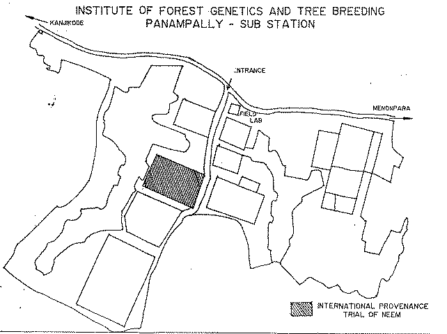
LOCATION
Province: Panampally
District:
Latitude (degrees and minutes): 11°17'N
Longitude (degrees and minutes): 77°07'E
Altitude (m above sea level):
Managing office/institution: India Council of Forestry Research and Education
Owner: do
User(s): do
Distance to nearest office responsible for management of the trial (km):
Distance to nearest villages/towns (km):
Number of inhabitants in the nearest villages/towns:
Type of area (e.g. research station, managed forest, etc.):
CLIMATE
Nearest weather station:
Name of the station:
Latitude (degrees and minutes):
Longitude (degrees and minutes):
Altitude (m a.s.l.):
|
Climatic data1 |
Jan. |
Feb. |
Mar. |
Apr. |
May |
June |
July |
Aug. |
Sep. |
Oct. |
Nov. |
Dec. |
Year |
|
Rainfall (mm) |
875 | ||||||||||||
|
Temp. mean (_C) |
|||||||||||||
|
Temp. mean max.2 (_C) |
35 | ||||||||||||
|
Temp. mean min.3 (_C) |
25 | ||||||||||||
|
Evapotranspiration4 (mm) |
1 Period of observations:.........(specify years) 2 Average of daily maximum temperatures
3 Average of daily minimum temperatures 4 Potential evapotranspiration (ETP) - Penman's formula
Rainy season:
|
Number/type of seasons: |
one |
two |
even/irregular |
Period(s): (specify months)
Length of rainy season:
No. of intermediate days: (pre- and posthumid period of the growing season)
No. of wet days: (growing season)
Number of dry months per year (< 50 mm rain/month):
Frost (number of days/year):
Prevailing winds (direction, period, speed):
TOPOGRAPHY (slope) of trial site
|
Flat/gentle (0-8%) |
Intermediate (9-30%) |
Steep (>30%) |
|
GENERAL SOIL DESCRIPTION |
|
Soil texture |
Soil depth |
Soil drainage/ Waterlogging |
Gravel content, topsoil | ||||
|
1. Light/sandy |
1. Shallow (< 50 cm) |
1. Well drained |
1. None (< 15 %) |
||||
|
2. Medium/loamy |
X |
2. Deep (50-100 cm) |
2. Seasonal |
2. Gravelly (15-35 %) |
|||
|
3. Heavy/clayey |
3. Very deep (> 100 cm) |
3. Permanent |
3. Stony (> 35 %) |
||||
|
Organic matter content |
Reaction (pH) |
Soil salinity |
Groundwater | ||||
|
1. Poor (< 2 % DM) |
1. Acid (pH < 6.5) |
1. None |
1. Shallow (< 50 cm) |
||||
|
2. Medium (2-5 % DM) |
2. Neutral (6.5-7.5) |
2. Moderate |
2. Deep (50 - 150 cm) |
||||
|
3. Rich (> 5 %) |
3. Alkaline (pH> 7.5) |
3. High |
3. Very deep (>150 cm) |
||||
Specify soil unit, soil association and phases (subdivisions of soil units) according to the Soil map of the world (FAO-Unesco 1971-1979), if known:
VEGETATION
Natural (original) vegetation type:
Dominant natural (original) genera/species:
Land use history
Apparent major problems of site (pests, diseases, etc):.
Economic data, viz. farm gate prices for fodder, fuel wood, small size timber,
extractives, and other minor produce:
TRIAL ESTABLISHMENT AND MANAGEMENT
Year and month of establishment: July 1996
Area (ha): 2 ha
Initial spacing (m x m): 3 x 3 m
Soil preparation (time, method/intensity):
Planting method (age of seedlings, type):
Beating up (time, %):
Irrigation (time, amount):
Fertilization (time, type, amount):
Weeding (time, intensity):
Thinning (time, intensity):
Firelines:
TRIAL DESIGN
Statistical design: Randomised complete block design
No. of replications (blocks): 4 replications
No. of treatments (provenances): 18
Plot size (No. of trees in plot): 25 (Vientiane 16)
Demarcation (blocks, plots):
PROVENANCES TESTED
Marked provenances have been included in the trial:
|
Nazir Hat (01/BGD/Naz) |
Annur (06/IND/Ann) |
Vientiane (11/LAO/Vie) |
Tibbi Laran (16/PAK/Tib) |
Ban Bo (21/THA/Bo) |
|
Chapai Nawabganj (02/BGD/Cha) |
Ghaati Subramanya (07/IND/Gha) |
Yezin (12/MYA/Yez) |
Multan (17/PAK/Mul) |
Doi Tao (22/THA/Doi) |
|
Mandore (03/IND/Man) |
Sagar Chanatoria (08/IND/Sag) |
Myene (13/MYA/Mye) |
Kuliyapitiya (18/SRL/Kul) |
Sunyani (23/GHA/Sun) |
|
Chitradurga (04/IND/Chi) |
Balharshah (09/IND/Bal) |
Lamahi (14/NEP/Lam) |
Tung Luang (19/THA/Thu) |
Bandia (24/SEN/Ban) |
|
Allahabad (05/IND/All) |
Ramannaguda (10/IND/Ram) |
Geta (15/NEP/Get) |
Ban Nong Rong 1 (20/THA/Non) |
Chamwino (25/TAN/Cha) |
Names of any local provenances included in the trial: Panampally, Kulapachra and Kalyani
PROTECTION STATUS:
Status (describe any disturbances/damages):
Guarding (permanent, regular, none):
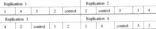
Location map Panampally, India 6
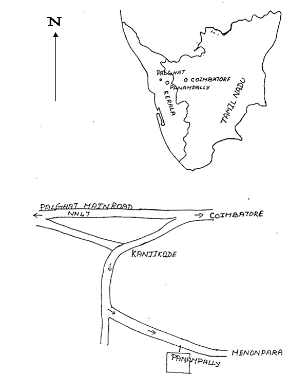
Location map Panampally, India 6
Design map Panampally, India 6
Legend:
|
Local No.: |
International No.: |
Local No.: |
International No.: |
Local No.: |
International No.: |
|
1 |
19/THA/Thu |
7 |
15/NEP/Get |
13 |
08/IND/Sag |
|
2 |
20/THA/Non |
8 |
25/TAN/Cha |
14 |
06/IND/Ann |
|
3 |
22/THA/Doi |
9 |
10/IND/Ram |
15 |
03/IND/Man |
|
4 |
11/LAO/Vie |
10 |
Kulapachra (India) |
16 |
05/IND/All |
|
5 |
12/MYA/Yes |
11 |
Kalyani (India) |
17 |
07/IND/Gha |
|
6 |
14/NEP/Lam |
12 |
09/IND/Bal |
18 |
Control (local provenance) |
![]()
![]()
![]()