![]()
![]()
![]()
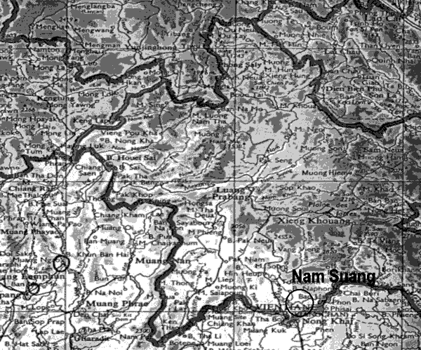
LOCATION
Province: Vientiane Municipality
District: Na Xay Thong
Latitude (degrees and minutes): 18°17'00"N
Longitude (degrees and minutes): 102º26'45"E
Altitude (m above sea level): 180 m
Managing office/institution: Forestry Research Center
Owner: do....
User(s): do...
Distance to nearest office responsible for management of the trial (km): 3 km
Distance to nearest villages/towns (km): 0.5 km
Number of inhabitants in the nearest villages/towns:
Type of area (e.g. research station, managed forest, etc.): Plantation 3 kms from Forest Research Centre Office and surrounded by Euc. camaldulensis plantation to the south ,test plantations of fast growing exotic species of ACIAR to the east and main road to Nam Suang in the west.
CLIMATE
Nearest weather station:
Name of the station: Nam Suang Forest Research Station
Latitude (degrees and minutes): 18°17'00"N
Longitude (degrees and minutes): 102º26'45"E
Altitude (m a.s.l.): 180 m
Climatic data1 |
Jan. |
Feb. |
Mar. |
Apr. |
May |
June |
July |
Aug. |
Sep. |
Oct. |
Nov. |
Dec. |
Year |
Rainfall (mm) |
0 |
100.5 |
87 |
43 |
110 |
259 |
169 |
462 |
285 |
10 |
102 |
0 |
1628 mm |
Temp. mean (_C) |
27.7 |
28.3 |
32.0 |
29.7 |
31.0 |
29.0 |
28.0 |
29.0 |
28.0 |
28.0 |
26.0 |
22.0 |
27.0°C |
Temp. mean max.2 (_C) |
29.0 |
29.6 |
32.7 |
32.6 |
32.9 |
30.5 |
29.0 |
30.5 |
29.0 |
29.0 |
27.0 |
24.0 |
30.5°C |
Temp. mean min.3 (_C) |
25.5 |
27.0 |
29.8 |
26.7 |
28.8 |
27.5 |
27.0 |
27.5 |
27.0 |
27.0 |
25.0 |
20.0 |
24.0°C |
Evapotranspiration4 (mm) |
1 Period of observations:..1996.....(specify years) 2 Average of daily maximum temperatures
3 Average of daily minimum temperatures 4 Potential evapotranspiration (ETP) - Penman's formula
Rainy season:
Number/type of seasons: |
x |
one |
two |
even/irregular |
Period(s): June - September (specify months)
Length of rainy season:
No. of intermediate days: (pre- and posthumid period of the growing season)
No. of wet days: (growing season)
Number of dry months per year (< 50 mm rain/month):
Frost (number of days/year): None
Prevailing winds (direction, period, speed): From West to East in July; from East to West in November; prevailing winds speed 11 km/h (in average per year)
TOPOGRAPHY (slope) of trial site
x |
Flat/gentle (0-8%) |
Intermediate (9-30%) |
Steep (>30%) |
GENERAL SOIL DESCRIPTION |
Soil texture |
Soil depth |
Soil drainage/ Waterlogging |
Gravel content, topsoil | ||||
1. Light/sandy |
X |
1. Shallow (< 50 cm) |
x |
1. Well drained |
x |
1. None (< 15 %) |
x |
2. Medium/loamy |
2. Deep (50-100 cm) |
2. Seasonal |
2. Gravelly (15-35 %) |
||||
3. Heavy/clayey |
3. Very deep (> 100 cm) |
3. Permanent |
3. Stony (> 35 %) |
||||
Organic matter content |
Reaction (pH) |
Soil salinity |
Groundwater | ||||
1. Poor (< 2 % DM) |
X |
1. Acid (pH < 6.5) |
x |
1. None |
x |
1. Shallow (< 50 cm) |
|
2. Medium (2-5 % DM) |
2. Neutral (6.5-7.5) |
2. Moderate |
2. Deep (50 - 150 cm) |
||||
3. Rich (> 5 %) |
3. Alkaline (pH> 7.5) |
3. High |
3. Very deep (>150 cm) |
x | |||
Specify soil unit, soil association and phases (subdivisions of soil units) according to the Soil map of the world (FAO-Unesco 1971-1979), if known:
VEGETATION
Natural (original) vegetation type: Evergreen forest
Dominant natural (original) genera/species: Pterocarpus macrocarpus, Afzelia xylocarpa, Hopea odorata, Vatinia astrotricha, Terminalia corticasa, Dipterocarpus alatus, Dysoxylon loureiri, Alstoniasholaris and Bamboos
Land use history: Before 1960 it was evergreen forest. Since 1960, immigrants from Hou Phan province in Northern part of Laos settled in this area. The land belonged to the state, but suffered from lack of proper management. In 1986 Department of Forestry established Nam Suang Silvicultural Station and established a Pterocarpus plantation. The objective of the establishment of Pterocarpus plantation was to protect the environment. Due to lack of maintenance, the survival rate of the trees was very low, with the result that nearly all trees died (0.3% survived). Because of the low survival rate the area was converted into Neem trial plantation.
Apparent major problems of site (pests, diseases, etc):.Grasshoppers, Anthonomus grandis (ball weevil.) Stagmomantis carolina and storm
Economic data, viz. farm gate prices for fodder, fuel wood, small size timber,
extractives, and other minor produce:
TRIAL ESTABLISHMENT AND MANAGEMENT
Year and month of establishment: July 1996
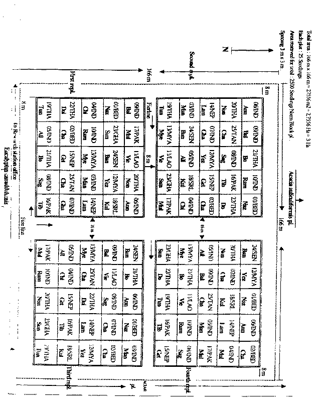
Area (ha): 2.75 ha
Initial spacing (m x m): 3x3
Soil preparation (time, method/intensity): Area opened up by bulldozer and tractor 11-15 July - soil
ploughed and loosened 15, 16, 19 July, digging of planting holes
Planting method(age of seedlings, type): age of seedlings - variable up to 1 year; planting holes - 25 cm deep and 25 cm in diameter
Beating up (time, %): About 150 seedlings replanted 2 weeks after planting
Irrigation (time, amount): In the first planting year, watering was performed twice - from September to December, approximately 9000 m3 each time
Fertilization (time, type, amount): After 1 month, NPK 15 15 15 at dose 50 gr./tree;
After 6 months, NPK 15 15 15 dose 70 gr./tree; After 1 year, NPK 15 15 15 dose 1 kg./tree
Weeding (time, intensity): 1st year: Weed clearing around the tree in diameter 50 cm, 1 year.
2nd year: Weed clearing around the tree in diameter 50 cm, 2 times/year
3rd year: Weed clearing around the tree in diameter 50 cm, 2 times/year
Thinning (time, intensity): None
Firelines: Tractor ploughed around the trail, 8 m in width once a year
TRIAL DESIGN
Statistical design: Randomised complete block design
No. of replications (blocks): 4 replications
No. of treatments (provenances): 25
Plot size (No. of trees in plot): 25 trees in each plot
Demarcation (blocks, plots): Posts 1 m long to mark the four corners of plots, and attached label
in each corners of the post to indicate direction of provenance
PROVENANCES TESTED
Marked provenances have been included in the trial:
Nazir Hat (01/BGD/Naz) |
Annur (06/IND/Ann) |
Vientiane (11/LAO/Vie) |
Tibbi Laran (16/PAK/Tib) |
Ban Bo (21/THA/Bo) |
Chapai Nawabganj (02/BGD/Cha) |
Ghaati Subramanya (07/IND/Gha) |
Yezin (12/MYA/Yez) |
Multan (17/PAK/Mul) |
Doi Tao (22/THA/Doi) |
Mandore (03/IND/Man) |
Sagar Chanatoria (08/IND/Sag) |
Myene (13/MYA/Mye) |
Kuliyapitiya (18/SRL/Kul) |
Sunyani (23/GHA/Sun) |
Chitradurga (04/IND/Chi) |
Balharshah (09/IND/Bal) |
Lamahi (14/NEP/Lam) |
Tung Luang (19/THA/Thu) |
Bandia (24/SEN/Ban) |
Allahabad (05/IND/All) |
Ramannaguda (10/IND/Ram) |
Geta (15/NEP/Get) |
Ban Nong Rong 1 (20/THA/Non) |
Chamwino (25/TAN/Cha) |
Names of any local provenances included in the trial:
PROTECTION STATUS:
Status (describe any disturbances/damages):
.
.
Guarding (permanent, regular, none): Twice a week in rainy season, and regularly in dry season
Location map Nam Suang, Lao P.D.R.
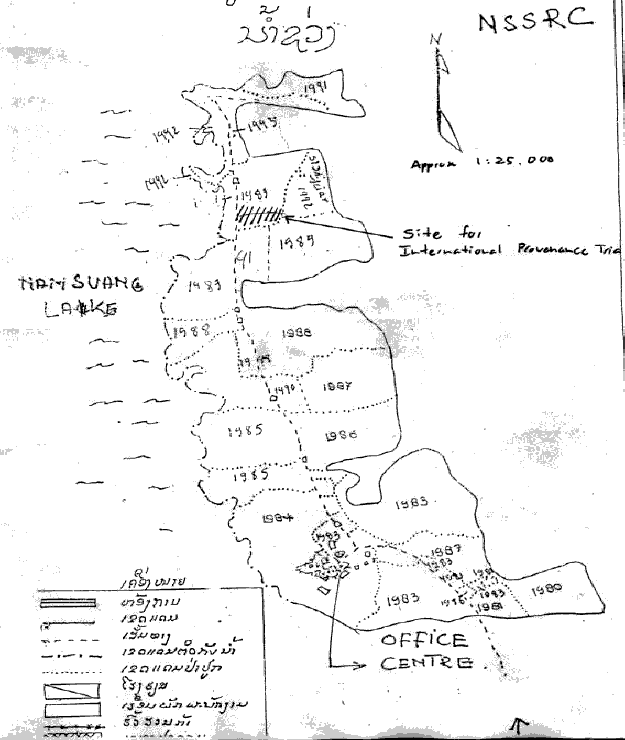
Design map Nam Suang, Lao P.D.R.
![]()
![]()
![]()