![]()
![]()
![]()
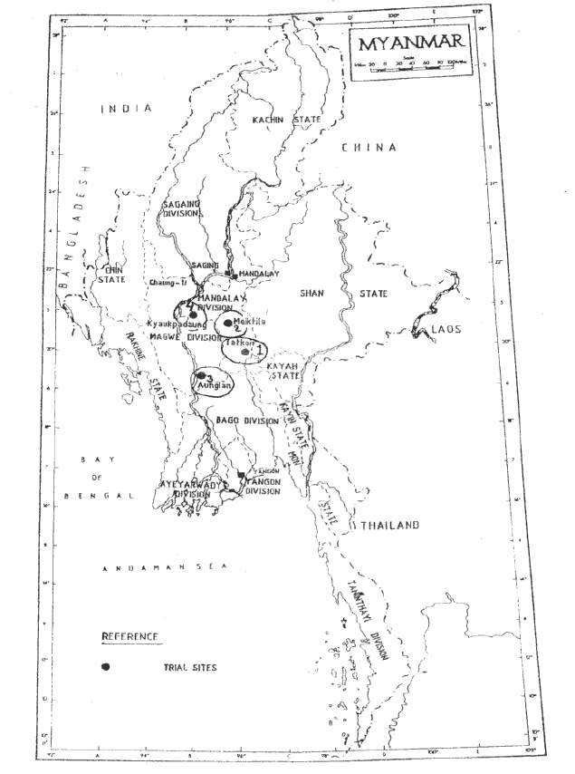
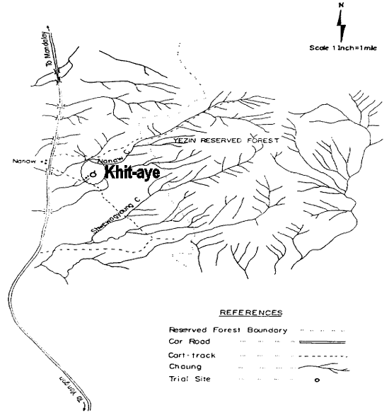
LOCATION
Province: Mandalay Division
District: Khit-aye, Takon Township, Yamehin District
Latitude (degrees and minutes): 20°15'N
Longitude (degrees and minutes): 96°15'E
Altitude (m above sea level): 180 m
Managing office/institution: Tatkon township office, Mandalay Division
Owner: do
User(s): do
Distance to nearest office responsible for management of the trial (km): 28.8 km
Distance to nearest villages/towns (km): 1.6 km
Number of inhabitants in the nearest villages/towns: 2380
Type of area (e.g. research station, managed forest, etc.): Yezin protected public forest
CLIMATE
Nearest weather station:
Name of the station: Myanmar Agricultural Service, Tatkon Meteorological Station
Latitude (degrees and minutes): 20º07'N
Longitude (degrees and minutes): 96º12'E
Altitude (m a.s.l.): 220 m
Climatic data1 1996 |
Jan. |
Feb. |
Mar. |
Apr. |
May |
June |
July |
Aug. |
Sep. |
Oct. |
Nov. |
Dec. |
Year |
Rainfall (mm) |
- |
56.3 |
6.00 |
53.3 |
165.3 |
339.0 |
182.5 |
372.5 |
230.8 |
117.0 |
85.8 |
- |
1608.3 mm |
Temp. mean (_C) |
20.7 |
27.4 |
29.0 |
29.0 |
27.3 |
27.6 |
27.5 |
26.6 |
25.9 |
25.6 |
24.5 |
22.6 |
26.1 |
Temp. mean max.2 (_C) |
31.5 |
33.9 |
34.7 |
37.1 |
35.9 |
36.6 |
36.2 |
34.0 |
34.8 |
32.6 |
32.9 |
32.0 |
34.4 |
Temp. mean min.3 (_C) |
11.8 |
15.2 |
19.7 |
24.0 |
23.3 |
23.8 |
22.7 |
22.1 |
22.6 |
22.0 |
20.1 |
17.2 |
20.4 |
Evapotranspiration4 (mm) |
1 Period of observations:...1. (Unknown).(specify years) 2 Average of daily maximum temperatures
3 Average of daily minimum temperatures 4 Potential evapotranspiration (ETP) - Penman's formula
Rainy season:
Number/type of seasons: |
x |
one |
two |
even/irregular |
Period(s): May-June-July-August-September-October (specify months)
Length of rainy season:
No. of intermediate days: (pre- and posthumid period of the growing season)
No. of wet days: (growing season)
Number of dry months per year (< 50 mm rain/month): 3
Frost (number of days/year):
Prevailing winds (direction, period, speed):
Rainfall regime: Transition-moist-dry
TOPOGRAPHY (slope) of trial site
X |
Flat/gentle (0-8%) |
Intermediate (9-30%) |
Steep (>30%) |
GENERAL SOIL DESCRIPTION |
Soil texture |
Soil depth |
Soil drainage/ Waterlogging |
Gravel content, topsoil | ||||
1. Light/sandy |
X |
1. Shallow (< 50 cm) |
x |
1. Well drained |
x |
1. None (< 15 %) |
x |
2. Medium/loamy |
X |
2. Deep (50-100 cm) |
2. Seasonal |
2. Gravelly (15-35 %) |
|||
3. Heavy/clayey |
3. Very deep (> 100 cm) |
3. Permanent |
3. Stony (> 35 %) |
||||
Organic matter content |
Reaction (pH) |
Soil salinity |
Groundwater | ||||
1. Poor (< 2 % DM) |
x |
1. Acid (pH < 6.5) |
x |
1. None |
x |
1. Shallow (< 50 cm) |
|
2. Medium (2-5 % DM) |
2. Neutral (6.5-7.5) |
2. Moderate |
2. Deep (50 - 150 cm) |
||||
3. Rich (> 5 %) |
3. Alkaline (pH> 7.5) |
3. High |
3. Very deep (>150 cm) |
x | |||
Specify soil unit, soil association and phases (subdivisions of soil units) according to the Soil map of the world (FAO-Unesco 1971-1979), if known:
VEGETATION
Natural (original) vegetation type: No vegetation cover except for tall grasses
Dominant natural (original) genera/species:
Land use history:
Apparent major problems of site (pests, diseases, etc):.
Economic data, viz. farm gate prices for fodder, fuel wood, small size timber,
extractives, and other minor produce:
TRIAL ESTABLISHMENT AND MANAGEMENT
Year and month of establishment: May 1996
Area (ha): 2.2 ha
Initial spacing (m x m): 3.6 x 3.6 m
Soil preparation (time, method/intensity): No ploughing necessary. Digging of planting pits
(1.8 x 0.5) to a depth of 0.45 m
Planting method (age of seedlings, type): Container seedlings, variable age
Beating up (time, %): One month after initial planting
Irrigation (time, amount):
Fertilization (time, type, amount): Manure (cow dung) applied at time of planting
Weeding (time, intensity): Manual. Spot weeding (within 30 cm) was carried out twice. In addition
one final and complete clearing of all weeds was carried out in December of the first year
Thinning (time, intensity):
Firelines: Firebreaks around the trial area were constructed before the beginning of the dry season
TRIAL DESIGN
Statistical design: Randomised complete block design
No. of replications (blocks): 4 replications
No. of treatments (provenances): 16
Plot size (No. of trees in plot): 25
Demarcation (blocks, plots): Teak thinning poles clearly marked at the corner of each plot with
labelling done in durable paint.)
PROVENANCES TESTED
Marked provenances have been included in the trial:
Nazir Hat (01/BGD/Naz) |
Annur (06/IND/Ann) |
Vientiane (11/LAO/Vie) |
Tibbi Laran (16/PAK/Tib) |
Ban Bo (21/THA/Bo) |
Chapai Nawabganj (02/BGD/Cha) |
Ghaati Subramanya (07/IND/Gha) |
Yezin (12/MYA/Yez) |
Multan (17/PAK/Mul) |
Doi Tao (22/THA/Doi) |
Mandore (03/IND/Man) |
Sagar Chanatoria (08/IND/Sag) |
Myene (13/MYA/Mye) |
Kuliyapitiya (18/SRL/Kul) |
Sunyani (23/GHA/Sun) |
Chitradurga (04/IND/Chi) |
Balharshah (09/IND/Bal) |
Lamahi (14/NEP/Lam) |
Tung Luang (19/THA/Thu) |
Bandia (24/SEN/Ban) |
Allahabad (05/IND/All) |
Ramannaguda (10/IND/Ram) |
Geta (15/NEP/Get) |
Ban Nong Rong 1 (20/THA/Non) |
Chamwino (25/TAN/Cha) |
Names of any local provenances included in the trial: Yezin (12/MYA/Yez) , Myene (13/MYA/Mye)
PROTECTION STATUS:
Status (describe any disturbances/damages): Some seedlings damaged by insects
Guarding (permanent, regular, none): A forest guard assigned on a permanent basis to
secure trial from encroachment by humans, animals and risk of fire.
Location map - Khit-aye, Tatkon, Myanmar 1
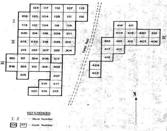
Legend:
Local No.: |
International No.: |
Local No.: |
International No.: |
Local No.: |
International No.: |
X04 |
04/IND/CHI |
X14 |
14/NEP/Lam |
X22 |
22/THA/Doi |
X06 |
06/IND/Ann |
X15 |
15/NEP/Get |
X23 |
23/GHA/Sun |
X07 |
07/IND/Gha |
X16 |
16/PAK/Tib |
X24 |
24/SEN/Ban |
X11 |
11/LAO/Vie |
X17 |
17/PAK/Mul |
X25 |
25/TAN/Cha |
X12 |
12/MYA/Yes |
X18 |
18/SRL/Kul |
||
X13 |
13/MYA/Mye |
X20 |
20/THA/Non |
X = block (1-4)
LOCATION
Province: Mandalay Division
District: Meiktila Township, Meiktila District
Latitude (degrees and minutes): 20°45'N
Longitude (degrees and minutes): 95°40'E
Altitude (m above sea level): 360 m
Managing office/institution: Meikthila township office, Mandalay Division
Owner: do
User(s): do
Distance to nearest office responsible for management of the trial (km): 52.8 km
Distance to nearest villages/towns (km): 1.6 km
Number of inhabitants in the nearest villages/towns: 258
Type of area (e.g. research station, managed forest, etc.): A former Eucalyptus plantation established
in 1978, where encroachment and illegal fellings had taken place. Coppicing of Eucalyptus can be found scattered all over the area
CLIMATE
Nearest weather station:
Name of the station: Meiktila Township Meteorological Station
Latitude (degrees and minutes): 20º53'N
Longitude (degrees and minutes):95º52'E
Altitude (m a.s.l.): 255 m
Climatic data1 1996 |
Jan. |
Feb. |
Mar. |
Apr. |
May |
June |
July |
Aug. |
Sep. |
Oct. |
Nov. |
Dec. |
Year |
Rainfall (mm) |
30.25 |
72.25 |
2.50 |
173.3 |
18.50 |
360.1 |
296.7 |
69.00 |
81.50 |
1104 mm | |||
Temp. mean (_C) |
24.8 |
29.6 |
30.4 |
32.6 |
31.6 |
30.6 |
30.9 |
29.6 |
27.9 |
26.6 |
26.5 |
23.8 |
26.84 |
Temp. mean max.2 (_C) |
34.5 |
36.9 |
38.8 |
39.6 |
39.9 |
39.6 |
38.0 |
37.8 |
38.8 |
36.7 |
35.6 |
35-0 |
37.6 |
Temp. mean min.3 (_C) |
12.9 |
17.8 |
26.0 |
24.8 |
24.9 |
23.7 |
24.8 |
24.6 |
25.0 |
22.1 |
21.2 |
19.2 |
22.25 |
Evapotranspiration4 (mm) |
1 Period of observations:.........(specify years) 2 Average of daily maximum temperatures
3 Average of daily minimum temperatures 4 Potential evapotranspiration (ETP) - Penman's formula
Rainy season:
Number/type of seasons: |
one |
x |
two |
even/irregular |
Period(s): June, August and September (specify months)
Length of rainy season:
No. of intermediate days: (pre- and posthumid period of the growing season)
No. of wet days: (growing season)
Number of dry months per year (< 50 mm rain/month): 6
Frost (number of days/year):
Prevailing winds (direction, period, speed):
TOPOGRAPHY (slope) of trial site
X |
Flat/gentle (0-8%) |
Intermediate (9-30%) |
Steep (>30%) |
GENERAL SOIL DESCRIPTION |
Soil texture |
Soil depth |
Soil drainage/ Waterlogging |
Gravel content, topsoil | ||||
1. Light/sandy |
1. Shallow (< 50 cm) |
x |
1. Well drained |
X |
1. None (< 15 %) |
||
2. Medium/loamy |
X |
2. Deep (50-100 cm) |
2. Seasonal |
2. Gravelly (15-35 %) |
x | ||
3. Heavy/clayey |
3. Very deep (> 100 cm) |
3. Permanent |
3. Stony (> 35 %) |
||||
Organic matter content |
Reaction (pH) |
Soil salinity |
Groundwater | ||||
1. Poor (< 2 % DM) |
x |
1. Acid (pH < 6.5) |
1. None |
x |
1. Shallow (< 50 cm) |
||
2. Medium (2-5 % DM) |
2. Neutral (6.5-7.5) |
2. Moderate |
2. Deep (50 - 150 cm) |
||||
3. Rich (> 5 %) |
3. Alkaline (pH> 7.5) |
x |
3. High |
3. Very deep (>150 cm) |
x | ||
Specify soil unit, soil association and phases (subdivisions of soil units) according to the Soil map of the world (FAO-Unesco 1971-1979), if known:
VEGETATION
Natural (original) vegetation type: Tall grasses
Dominant natural (original) genera/species:
Land use history: A former Eucalyptus plantation established in 1978, where encroachment and illegal fellings
took place. Coppicing of Eucalyptus can be found scattered all over the area
Apparent major problems of site (pests, diseases, etc):.
Economic data, viz. farm gate prices for fodder, fuel wood, small size timber,
extractives, and other minor produce:
TRIAL ESTABLISHMENT AND MANAGEMENT
Year and month of establishment: June 1996
Area (ha): 2.6 ha
Initial spacing (m x m): 4 x 4 m
Soil preparation (time, method/intensity): No ploughing necessary. Digging of planting holes
(1.8 x 0.5 m) to a depth of 0.45 m
Planting method (age of seedlings, type): Container seedlings, variable age
Beating up (time, %): One month after initial planting
Irrigation (time, amount):
Fertilization (time, type, amount): Manure (cow dung) applied at time of planting
Weeding (time, intensity): Manual. Spot weeding (30 cm) twice during first year. Plus, one
additional complete clearing of all weeds was carried out in December of year of establishment
Thinning (time, intensity):
Firelines: Firebreaks around the trial area were constructed before the beginning of the dry season
TRIAL DESIGN
Statistical design: Randomized complete block design
No. of replications (blocks): 4 replications
No. of treatments (provenances): 16
Plot size (No. of trees in plot): 25
Demarcation (blocks, plots): Teak thinning poles clearly marked at the corner of each plot with
labelling done in durable paint.)
PROVENANCES TESTED
Marked provenances have been included in the trial:
Nazir Hat (01/BGD/Naz) |
Annur (06/IND/Ann) |
Vientiane (11/LAO/Vie) |
Tibbi Laran (16/PAK/Tib) |
Ban Bo (21/THA/Bo) |
Chapai Nawabganj (02/BGD/Cha) |
Ghaati Subramanya (07/IND/Gha) |
Yezin (12/MYA/Yez) |
Multan (17/PAK/Mul) |
Doi Tao (22/THA/Doi) |
Mandore (03/IND/Man) |
Sagar Chanatoria (08/IND/Sag) |
Myene (13/MYA/Mye) |
Kuliyapitiya (18/SRL/Kul) |
Sunyani (23/GHA/Sun) |
Chitradurga (04/IND/Chi) |
Balharshah (09/IND/Bal) |
Lamahi (14/NEP/Lam) |
Tung Luang (19/THA/Thu) |
Bandia (24/SEN/Ban) |
Allahabad (05/IND/All) |
Ramannaguda (10/IND/Ram) |
Geta (15/NEP/Get) |
Ban Nong Rong 1 (20/THA/Non) |
Chamwino (25/TAN/Cha) |
Names of any local provenances included in the trial: Yezin (12/MYA/Yez), Myene (13/MYA/Mye)
PROTECTION STATUS:
Status (describe any disturbances/damages):
Guarding (permanent, regular, none): Forest guard assigned on a permanent basis to secure trial
from encroachment, animals and fires
Legend:
Local No.: |
International No.: |
Local No.: |
International No.: |
Local No.: |
International No.: |
X04 |
04/IND/CHI |
X14 |
14/NEP/Lam |
X22 |
22/THA/Doi |
X06 |
06/IND/Ann |
X15 |
15/NEP/Get |
X23 |
23/GHA/Sun |
X07 |
07/IND/Gha |
X16 |
16/PAK/Tib |
X24 |
24/SEN/Ban |
X11 |
11/LAO/Vie |
X17 |
17/PAK/Mul |
X25 |
25/TAN/Cha |
X12 |
12/MYA/Yes |
X18 |
18/SRL/Kul |
||
X13 |
13/MYA/Mye |
X20 |
20/THA/Non |
X = block (1-4)
LOCATION
Province: Magwe Division
District: Aunglan Township Office, Kywe-the, Thayet District
Latitude (degrees and minutes): 18°55'N
Longitude (degrees and minutes): 95°20'E
Altitude (m above sea level): 85 m
Managing office/institution: Aunglan Township Office
Owner: do
User(s): do
Distance to nearest office responsible for management of the trial (km): 40 km
Distance to nearest villages/towns (km): 1.6 km
Number of inhabitants in the nearest villages/towns: 156
Type of area (e.g. research station, managed forest, etc.): Reforestation area
CLIMATE
Nearest weather station:
Name of the station: Aunglan Township Meteorological Station
Latitude (degrees and minutes): 19º22'N
Longitude (degrees and minutes): 95º10'E
Altitude (m a.s.l.): 64 m
Climatic data1 |
Jan. |
Feb. |
Mar. |
Apr. |
May |
June |
July |
Aug. |
Sep. |
Oct. |
Nov. |
Dec. |
Year |
Rainfall (mm) |
42.2 |
4.25 |
52.5 |
155.3 |
330.8 |
162.3 |
380.5 |
220.8 |
82.8 |
85.3 |
1516.7 | ||
Temp. mean (_C) |
20.2 |
22.7 |
26.3 |
29.0 |
29.2 |
27.2 |
27.6 |
27.4 |
26.3 |
25.8 |
24.3 |
22.7 |
25.73 |
Temp. mean max.2 (_C) |
33.3 |
33.6 |
38.6 |
36.8 |
37.0 |
38.8 |
37.4 |
36.8 |
34.0 |
36.8 |
32.4 |
34.0 |
35.79 |
Temp. mean min.3 (_C) |
12.6 |
15.8 |
20.3 |
22.8 |
25.6 |
25.8 |
22.4 |
24.2 |
24.5 |
20.3 |
20.0 |
16.2 |
20.87 |
Evapotranspiration4 (mm) |
1 Period of observations:.........(specify years) 2 Average of daily maximum temperatures
3 Average of daily minimum temperatures 4 Potential evapotranspiration (ETP) - Penman's formula
Rainy season:
Number/type of seasons: |
x |
one |
two |
even/irregular |
Period(s): May - June - July - August - September (specify months)
Length of rainy season:
No. of intermediate days: (pre- and posthumid period of the growing season)
No. of wet days: (growing season)
Number of dry months per year (< 50 mm rain/month): 4
Frost (number of days/year):
Prevailing winds (direction, period, speed):
TOPOGRAPHY (slope) of trial site
X |
Flat/gentle (0-8%) |
Intermediate (9-30%) |
Steep (>30%) |
GENERAL SOIL DESCRIPTION |
Soil texture |
Soil depth |
Soil drainage/ Waterlogging |
Gravel content, topsoil | ||||
1. Light/sandy |
x |
1. Shallow (< 50 cm) |
x |
1. Well drained |
x |
1. None (< 15 %) |
x |
2. Medium/loamy |
x |
2. Deep (50-100 cm) |
2. Seasonal |
2. Gravelly (15-35 %) |
|||
3. Heavy/clayey |
3. Very deep (> 100 cm) |
3. Permanent |
3. Stony (> 35 %) |
||||
Organic matter content |
Reaction (pH) |
Soil salinity |
Groundwater | ||||
1. Poor (< 2 % DM) |
x |
1. Acid (pH < 6.5) |
1. None |
x |
1. Shallow (< 50 cm) |
||
2. Medium (2-5 % DM) |
2. Neutral (6.5-7.5) |
x |
2. Moderate |
2. Deep (50 - 150 cm) |
|||
3. Rich (> 5 %) |
3. Alkaline (pH> 7.5) |
3. High |
3. Very deep (>150 cm) |
x | |||
Specify soil unit, soil association and phases (subdivisions of soil units) according to the Soil map of the world (FAO-Unesco 1971-1979), if known:
VEGETATION
Natural (original) vegetation type: Scrub Dipterocarps
Dominant natural (original) genera/species: Dipterocarps Spp.
Land use history:
Apparent major problems of site (pests, diseases, etc):.
Economic data, viz. farm gate prices for fodder, fuel wood, small size timber,
extractives, and other minor produce:
TRIAL ESTABLISHMENT AND MANAGEMENT
Year and month of establishment: June 1996
Area (ha): 2 ha
Initial spacing (m x m): 3.6 x 3.6 m
Soil preparation (time, method/intensity): No ploughing necessary. Digging of planting pits
(1.8 x 0.5 m) to a depth of 0.45 m
Planting method (age of seedlings, type): Container seedlings.of variable age
Beating up (time, %): One month after initial planting
Irrigation (time, amount):
Fertilization (time, type, amount): Manure (cow dung) applied at the time of establishment
Weeding (time, intensity): Manual. Spot weeding (30 cm) twice during first year. Plus, one
additional complete clearing of all weeds was carried out in December of year of establishment
Thinning (time, intensity):
Firelines: Firebreaks around the trial area were constructed before the beginning of the dry season
TRIAL DESIGN
Statistical design: Randomised complete block design
No. of replications (blocks): 4 replications
No. of treatments (provenances): 15
Plot size (No. of trees in plot): 25
Demarcation (blocks, plots): Teak thinning poles clearly marked at the corner of each plot with
labelling done in durable paint.)
PROVENANCES TESTED
Marked provenances have been included in the trial:
Nazir Hat (01/BGD/Naz) |
Annur (06/IND/Ann) |
Vientiane (11/LAO/Vie) |
Tibbi Laran (16/PAK/Tib) |
Ban Bo (21/THA/Bo) |
Chapai Nawabganj (02/BGD/Cha) |
Ghaati Subramanya (07/IND/Gha) |
Yezin (12/MYA/Yez) |
Multan (17/PAK/Mul) |
Doi Tao (22/THA/Doi) |
Mandore (03/IND/Man) |
Sagar Chanatoria (08/IND/Sag) |
Myene (13/MYA/Mye) |
Kuliyapitiya (18/SRL/Kul) |
Sunyani (23/GHA/Sun) |
Chitradurga (04/IND/Chi) |
Balharshah (09/IND/Bal) |
Lamahi (14/NEP/Lam) |
Tung Luang (19/THA/Thu) |
Bandia (24/SEN/Ban) |
Allahabad (05/IND/All) |
Ramannaguda (10/IND/Ram) |
Geta (15/NEP/Get) |
Ban Nong Rong 1 (20/THA/Non) |
Chamwino (25/TAN/Cha) |
Names of any local provenances included in the trial: Yezin (12/MYA/Yes), Myene (13/MYA/Mye)
PROTECTION STATUS:
Status (describe any disturbances/damages): Some young plants were attacked by insects, but considerable damage to the seedlings and young plants were not found
Guarding (permanent, regular, none): Four forest guards assigned on a permanent basis to secure the trial from encroachment by humans, animals and also from the risk of fires.
Legend:
Local No.: |
International No.: |
Local No.: |
International No.: |
Local No.: |
International No.: |
X04 |
04/IND/CHI |
X14 |
14/NEP/Lam |
X22 |
22/THA/Doi |
X06 |
06/IND/Ann |
X15 |
15/NEP/Get |
X23 |
23/GHA/Sun |
X07 |
07/IND/Gha |
X16 |
16/PAK/Tib |
X24 |
24/SEN/Ban |
X11 |
11/LAO/Vie |
X17 |
17/PAK/Mul |
X25 |
25/TAN/Cha |
X12 |
12/MYA/Yes |
X18 |
18/SRL/Kul |
||
X13 |
13/MYA/Mye |
X20 |
20/THA/Non |
X = block (1-4)
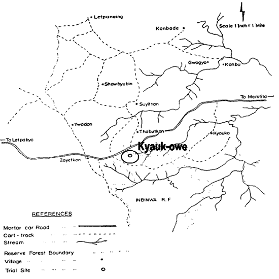
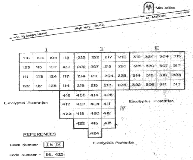
This trial, located in Kyaukpadaung Township, Mandalay Division, has been abandoned. Soon after trial establishment in 1996, railroad construction was carried out and two blocks of trial had to be moved. When seedlings were replanted, there was not enough moisture in the soil, and the seedlings did not survive.
![]()
![]()
![]()