![]()
![]()
![]()
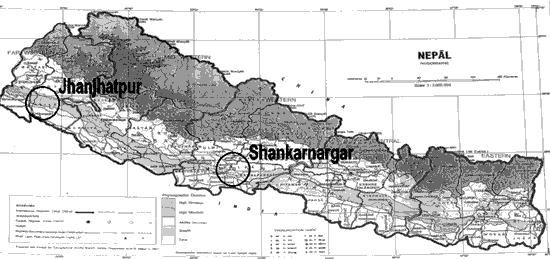
LOCATION
Province: Far-western development region of Nepal
District: Kailali district
Latitude (degrees and minutes): 28°34'N
Longitude (degrees and minutes): 80°34'E
Altitude (m above sea level): 200
Managing office/institution: Department of Forest Research and Survey
Owner: Depertment of Forest
User(s): Forest User Group of Shankarnagar
Distance to nearest office responsible for management of the trial (km): < 1 km
Distance to nearest villages/towns (km):
Number of inhabitants in the nearest villages/towns:
Type of area (e.g. research station, managed forest, etc.):.
CLIMATE
Nearest weather station:
Name of the station: Dhangadhi Airport
Latitude (degrees and minutes):
Longitude (degrees and minutes):
Altitude (m a.s.l.):
Climatic data1 |
Jan. |
Feb. |
Mar. |
Apr. |
May |
June |
July |
Aug. |
Sep. |
Oct. |
Nov. |
Dec. |
Year |
Rainfall (mm) |
1725 mm | ||||||||||||
Temp. mean (_C) |
|||||||||||||
Temp. mean max.2 (_C) |
|||||||||||||
Temp. mean min.3 (_C) |
|||||||||||||
Evapotranspiration4 (mm) |
1 Period of observations:.........(specify years) 2 Average of daily maximum temperatures
3 Average of daily minimum temperatures 4 Potential evapotranspiration (ETP) - Penman's formula
Rainy season:
Number/type of seasons: |
x |
one |
two |
even/irregular |
Period(s): June to October (specify months)
Length of rainy season:
No. of intermediate days: (pre- and posthumid period of the growing season)
No. of wet days: (growing season)
Number of dry months per year (< 50 mm rain/month): 6
Frost (number of days/year):
Prevailing winds (direction, period, speed):
TOPOGRAPHY (slope) of trial site
X |
Flat/gentle (0-8%) |
Intermediate (9-30%) |
Steep (>30%) |
GENERAL SOIL DESCRIPTION |
Soil texture |
Soil depth |
Soil drainage/ Waterlogging |
Gravel content, topsoil | ||||
1. Light/sandy |
1. Shallow (< 50 cm) |
1. Well drained |
1. None (< 15 %) |
||||
2. Medium/loamy |
2. Deep (50-100 cm) |
2. Seasonal |
2. Gravelly (15-35 %) |
||||
3. Heavy/clayey |
3. Very deep (> 100 cm) |
3. Permanent |
3. Stony (> 35 %) |
||||
Organic matter content |
Reaction (pH) |
Soil salinity |
Groundwater | ||||
1. Poor (< 2 % DM) |
1. Acid (pH < 6.5) |
1. None |
1. Shallow (< 50 cm) |
||||
2. Medium (2-5 % DM) |
2. Neutral (6.5-7.5) |
2. Moderate |
2. Deep (50 - 150 cm) |
||||
3. Rich (> 5 %) |
3. Alkaline (pH> 7.5) |
3. High |
3. Very deep (>150 cm) |
||||
Specify soil unit, soil association and phases (subdivisions of soil units) according to the Soil map of the world (FAO-Unesco 1971-1979), if known:
VEGETATION
Natural (original) vegetation type: Sal (Shorea robusta forest)
Dominant natural (original) genera/species: Shorea robusta, Syzigium cumunii, Terminalia belerica, Hollarhena antidyscentrica
Land use history: The site was sal forest (Shorea robusta) in the beginning but it was selectively harvested and hence was converted into a forest with miscellaneous tree species
Apparent major problems of site (pests, diseases, etc):.
Economic data, viz. farm gate prices for fodder, fuel wood, small size timber,
extractives, and other minor produce:
TRIAL ESTABLISHMENT AND MANAGEMENT
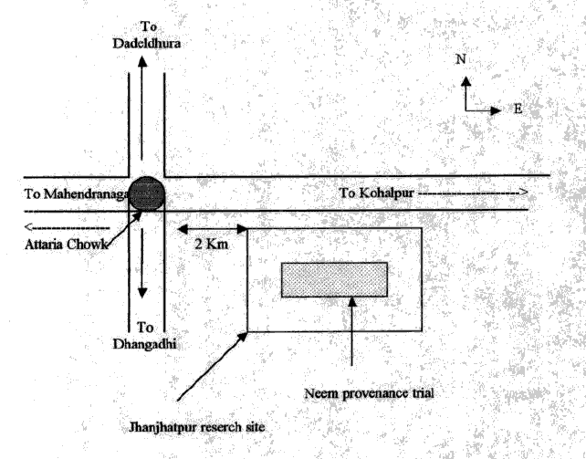
Year and month of establishment: October 1996
Area (ha): 1.1 ha ( two replicates); 1.7 ha of three replicates
Initial spacing (m x m): 4 x 2 m
Soil preparation (time, method/intensity): Land cleared March 1996. Pitting (30x30x30 cm)
Planting method(age of seedlings, type): Stumps of nine to fifteen months old were used
Beating up (time, %): Once in September 1996, 2.6% of the total number of stumps planted in July
1996
Irrigation (time, amount): No
Fertilization (time, type, amount):
Weeding (time, intensity): Two times in 1996 (August and October); three times in 1997 (February,
July and September), Three times in 1998 (April, July and November); two times in 1999 (June and October).
Thinning (time, intensity): No
Firelines: Maintained
TRIAL DESIGN
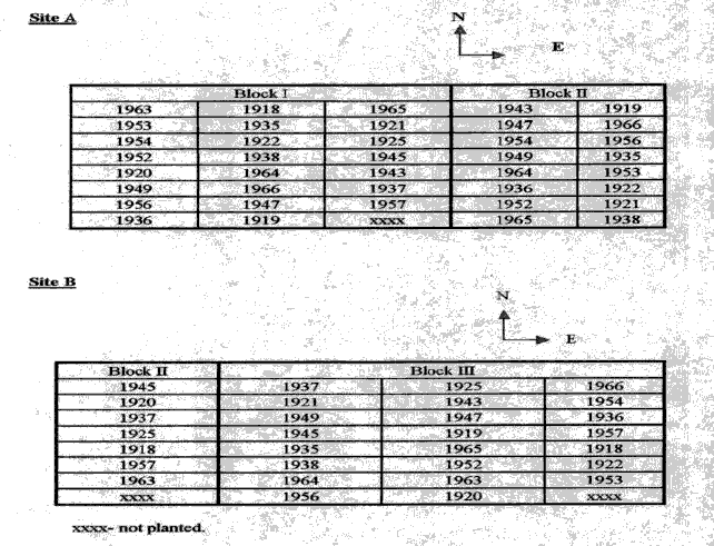
Statistical design: Randomised complete block design
No. of replications (blocks): 3 replications
No. of treatments (provenances): 19
Plot size (No. of trees in plot): Instead of 30 stumps, only 25 stumps were planted in case of Multan, Chamwino and Ramannagudu provenances due to insufficient number of seedlings of these
provenances.
Demarcation (blocks, plots):
PROVENANCES TESTED
Marked provenances have been included in the trial:
Nazir Hat (01/BGD/Naz) |
Annur (06/IND/Ann) |
Vientiane (11/LAO/Vie) |
Tibbi Laran (16/PAK/Tib) |
Ban Bo (21/THA/Bo) |
Chapai Nawabganj (02/BGD/Cha) |
Ghaati Subramanya (07/IND/Gha) |
Yezin (12/MYA/Yez) |
Multan (17/PAK/Mul) |
Doi Tao (22/THA/Doi) |
Mandore (03/IND/Man) |
Sagar Chanatoria (08/IND/Sag) |
Myene (13/MYA/Mye) |
Kuliyapitiya (18/SRL/Kul) |
Sunyani (23/GHA/Sun) |
Chitradurga (04/IND/Chi) |
Balharshah (09/IND/Bal) |
Lamahi (14/NEP/Lam) |
Tung Luang (19/THA/Thu) |
Bandia (24/SEN/Ban) |
Allahabad (05/IND/All) |
Ramannaguda (10/IND/Ram) |
Geta (15/NEP/Get) |
Ban Nong Rong 1 (20/THA/Non) |
Chamwino (25/TAN/Cha) |
Names of any local provenances included in the trial:
PROTECTION STATUS:
Status (describe any disturbances/damages):
Guarding (permanent, regular, none): Regular by two watchmen
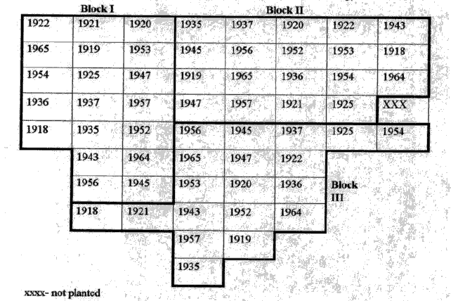
Legend:
Local No.: |
International No.: |
Local No.: |
International No.: |
Local No.: |
International No.: |
1918 |
21/THA/Bo |
1936 |
12/MYA/Yes |
1954 |
14/NEP/Lam |
1919 |
25/TAN/Cha |
1937 |
23/GHA/Sun |
1956 |
16/PAK/Tib |
1920 |
19/THA/Thu |
1943 |
13/MYA/Mye |
1957 |
17/PAK/Mul |
1921 |
22/THA/Doi |
1945 |
09/IND/Bal |
1964 |
04/IND/CHI |
1922 |
20/THA/Non |
1947 |
05/IND/All |
1965 |
24/SEN/Ban |
1925 |
11/LAO/Vie |
1952 |
06/IND/Ann |
||
1935 |
10/IND/Ram |
1953 |
15/NEP/Get |
LOCATION
Province: Western development region of Nepal
District: Rapundehi district
Latitude (degrees and minutes): 27°42'N
Longitude (degrees and minutes): 83°28'E
Altitude (m above sea level): 205
Managing office/institution: Forest Research and Survey Centre
Owner: do
User(s): do
Distance to nearest office responsible for management of the trial (km): 1.5 km
Distance to nearest villages/towns (km):
Number of inhabitants in the nearest villages/towns:
Type of area (e.g. research station, managed forest, etc.):. Research station
CLIMATE
Nearest weather station:
Name of the station: Butwal town
Latitude (degrees and minutes): 27°28'N
Longitude (degrees and minutes): 83°27'E
Altitude (m a.s.l.): 263
Climatic data1 |
Jan. |
Feb. |
Mar. |
Apr. |
May |
June |
July |
Aug. |
Sep. |
Oct. |
Nov. |
Dec. |
Year |
Rainfall (mm) |
14 |
17 |
18 |
25 |
97 |
389 |
774 |
666 |
451 |
108 |
12 |
15 |
2586 mm |
Temp. mean (_C) |
17.2 |
19.4 |
24.6 |
29.4 |
30.6 |
30.3 |
28.8 |
29.0 |
28.2 |
26.9 |
23.2 |
19.4 |
25.0 |
Temp. mean max.2 (_C) |
22.5 |
25.3 |
31.0 |
35.9 |
36.2 |
34.9 |
32.2 |
32.4 |
31.9 |
31.2 |
28.3 |
24.2 |
30.5 |
Temp. mean min.3 (_C) |
11.9 |
13.1 |
18.0 |
22.7 |
24.9 |
25.6 |
25.1 |
25.1 |
23.8 |
21.5 |
17.0 |
13.1 |
20.2 |
Evapotranspiration4 (mm) |
1 Period of observations:...1961-94......(specify years) 2 Average of daily maximum temperatures
3 Average of daily minimum temperatures 4 Potential evapotranspiration (ETP) - Penman's formula
Rainy season:
Number/type of seasons: |
x |
one |
two |
even/irregular |
Period(s): June to October (specify months)
Length of rainy season:
No. of intermediate days: 60 (pre- and posthumid period of the growing season)
No. of wet days: 120 (growing season)
Number of dry months per year (< 50 mm rain/month): 6
Frost (number of days/year): zero
Prevailing winds (direction, period, speed):
TOPOGRAPHY (slope) of trial site
X |
Flat/gentle (0-8%) |
Intermediate (9-30%) |
Steep (>30%) |
GENERAL SOIL DESCRIPTION |
Soil texture |
Soil depth |
Soil drainage/ Waterlogging |
Gravel content, topsoil | ||||
1. Light/sandy |
1. Shallow (< 50 cm) |
1. Well drained |
X |
1. None (< 15 %) |
X | ||
2. Medium/loamy |
X |
2. Deep (50-100 cm) |
2. Seasonal |
2. Gravelly (15-35 %) |
|||
3. Heavy/clayey |
3. Very deep (> 100 cm) |
X |
3. Permanent |
3. Stony (> 35 %) |
|||
Organic matter content |
Reaction (pH) |
Soil salinity |
Groundwater | ||||
1. Poor (< 2 % DM) |
1. Acid (pH < 6.5) |
1. None |
X |
1. Shallow (< 50 cm) |
|||
2. Medium (2-5 % DM) |
2. Neutral (6.5-7.5) |
2. Moderate |
2. Deep (50 - 150 cm) |
||||
3. Rich (> 5 %) |
3. Alkaline (pH> 7.5) |
3. High |
3. Very deep (>150 cm) |
X | |||
Specify soil unit, soil association and phases (subdivisions of soil units) according to the Soil map of the world (FAO-Unesco 1971-1979), if known:
VEGETATION
Natural (original) vegetation type: Sal forest (Shorea robusta)
Dominant natural (original) genera/species: Shorea robusta, Terminalia alata, T. belerica, Lagerstromia parviflora, Hollarhena antidyscentrica
Land use history: Sal forest depleted and degraded. Site earlier used for Dalbergia sissoo provenance trial which was completed April 96
Apparent major problems of site (pests, diseases, etc):.During the rainy season, lots of water flow from the north side(forest) in third replicate of the trial. Some provenances were completely washed away by rain. Third replicate had to be abandoned for assessment
Economic data, viz. farm gate prices for fodder, fuel wood, small size timber,
extractives, and other minor produce:
TRIAL ESTABLISHMENT AND MANAGEMENT
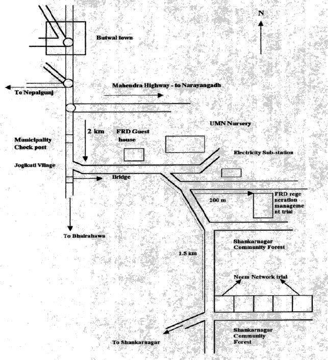
Year and month of establishment: July 1996
Area (ha):
Initial spacing (m x m): 4 x 2 m
Soil preparation (time, method/intensity): Pitting (30x30x30 cm)
Planting method(age of seedlings, type): Seedlings or stumps ??, 9-15 months of age
Beating up (time, %):
Irrigation (time, amount):
Fertilization (time, type, amount):
Weeding (time, intensity):
Thinning (time, intensity):
Firelines:
TRIAL DESIGN
Statistical design: Randomized complete block design
No. of replications (blocks): 3 replications
No. of treatments (provenances): 23
Plot size (No. of trees in plot): 30 (3 had 25 plants - Multan, Chamwino and Ramannaguda)
Demarcation (blocks, plots):
PROVENANCES TESTED
Marked provenances have been included in the trial:
Nazir Hat (01/BGD/Naz) |
Annur (06/IND/Ann) |
Vientiane (11/LAO/Vie) |
Tibbi Laran (16/PAK/Tib) |
Ban Bo (21/THA/Bo) |
Chapai Nawabganj (02/BGD/Cha) |
Ghaati Subramanya (07/IND/Gha) |
Yezin (12/MYA/Yez) |
Multan (17/PAK/Mul) |
Doi Tao (22/THA/Doi) |
Mandore (03/IND/Man) |
Sagar Chanatoria (08/IND/Sag) |
Myene (13/MYA/Mye) |
Kuliyapitiya (18/SRL/Kul) |
Sunyani (23/GHA/Sun) |
Chitradurga (04/IND/Chi) |
Balharshah (09/IND/Bal) |
Lamahi (14/NEP/Lam) |
Tung Luang (19/THA/Thu) |
Bandia (24/SEN/Ban) |
Allahabad (05/IND/All) |
Ramannaguda (10/IND/Ram) |
Geta (15/NEP/Get) |
Ban Nong Rong 1 (20/THA/Non) |
Chamwino (25/TAN/Cha) |
Names of any local provenances included in the trial: Jodhpur, India
PROTECTION STATUS:
Status (describe any disturbances/damages): During the rainy season, lots of water flow from the
north side(forest) in third replicate of the trial. Some provenances were completely washed away by rain. Third replicate had to be abandoned for assessment
Guarding (permanent, regular, none):
Legend:
Local No.: |
International No.: |
Local No.: |
International No.: |
Local No.: |
International No.: |
1918 |
21/THA/Bo |
1937 |
23/GHA/Sun |
1954 |
14/NEP/Lam |
1919 |
25/TAN/Cha |
1938 |
08/IND/Sag |
1956 |
16/PAK/Tib |
1920 |
19/THA/Thu |
1943 |
13/MYA/Mye |
1957 |
17/PAK/Mul |
1921 |
22/THA/Doi |
1945 |
09/IND/Bal |
1963 |
07/IND/Gha |
1922 |
20/THA/Non |
1947 |
05/IND/All |
1964 |
04/IND/CHI |
1925 |
11/LAO/Vie |
1949 |
03/IND/Man |
1965 |
24/SEN/Ban |
1935 |
10/IND/Ram |
1952 |
06/IND/Ann |
1966 |
18/SRL/Kul |
1936 |
12/MYA/Yes |
1953 |
15/NEP/Get |
![]()
![]()
![]()