![]()
![]()
![]()
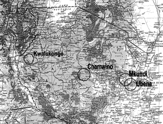
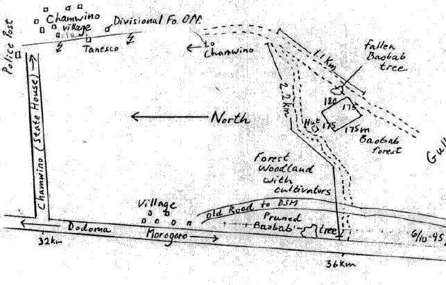
LOCATION
Province: Dodoma
District: Chamwino
Latitude (degrees and minutes): 06°02'S
Longitude (degrees and minutes): 34°39'E
Altitude (m above sea level): 910 m
Managing office/institution: Forest and Beekeeping Department, National Tree Seed Programme
Owner: Local villagers
User(s): National Tree Seed Programme
Distance to nearest office responsible for management of the trial (km):
Distance to nearest villages/towns (km): 2 km
Number of inhabitants in the nearest villages/towns:
Type of area (e.g. research station, managed forest, etc.): Public land
CLIMATE
Nearest weather station:
Name of the station: Dodoma meterological station (55 km from the trial)
Latitude (degrees and minutes): 6o02' S
Longitude (degrees and minutes): 34o49' E
Altitude (m a.s.l.): 1372 m
Climatic data1 |
Jan. |
Feb. |
Mar. |
Apr. |
May |
June |
July |
Aug. |
Sep. |
Oct. |
Nov. |
Dec. |
Year |
Rainfall (mm) |
143.9 |
117.3 |
118.6 |
50.4 |
4.5 |
0.7 |
0.0 |
0.0 |
00.9 |
4.0 |
21.4 |
108.2 |
569.9 mm |
Temp. mean (_C) |
22 |
22 |
22 |
22 |
20 |
19 |
18 |
19 |
21 |
22 |
23 |
22 |
21°C |
Temp. mean max.2 (_C) |
|||||||||||||
Temp. mean min.3 (_C) |
|||||||||||||
Evapotranspiration4 (mm) |
1 Period of observations:..45.......(specify years) 2 Average of daily maximum temperatures
3 Average of daily minimum temperatures 4 Potential evapotranspiration (ETP) - Penman's formula
Rainy season:
Number/type of seasons: |
x |
one |
two |
even/irregular |
Period(s): December, January, February, March (specify months)
Length of rainy season:
No. of intermediate days: 120 (pre- and posthumid period of the growing season)
No. of wet days: 100-120 (growing season)
Number of dry months per year (< 50 mm rain/month): 6 months
Frost (number of days/year):
Prevailing winds (direction, period, speed):
TOPOGRAPHY (slope) of trial site
x |
Flat/gentle (0-8%) |
Intermediate (9-30%) |
Steep (>30%) |
GENERAL SOIL DESCRIPTION |
Soil texture |
Soil depth |
Soil drainage/ Waterlogging |
Gravel content, topsoil | ||||
1. Light/sandy |
1. Shallow (< 50 cm) |
1. Well drained |
x |
1. None (< 15 %) |
x | ||
2. Medium/loamy |
2. Deep (50-100 cm) |
x |
2. Seasonal |
2. Gravelly (15-35 %) |
|||
3. Heavy/clayey |
3. Very deep (> 100 cm) |
3. Permanent |
3. Stony (> 35 %) |
||||
Organic matter content |
Reaction (pH) |
Soil salinity |
Groundwater | ||||
1. Poor (< 2 % DM) |
1. Acid (pH < 6.5) |
1. None |
x |
1. Shallow (< 50 cm) |
|||
2. Medium (2-5 % DM) |
x |
2. Neutral (6.5-7.5) |
2. Moderate |
2. Deep (50 - 150 cm) |
|||
3. Rich (> 5 %) |
3. Alkaline (pH> 7.5) |
3. High |
3. Very deep (>150 cm) |
x | |||
Specify soil unit, soil association and phases (subdivisions of soil units) according to the Soil map of the world (FAO-Unesco 1971-1979), if known:
VEGETATION
Natural (original) vegetation type: Miombo woodland
Dominant natural (original) genera/species: Xymeria americana, Acacia spp., Adansonia digitata
Land use history: This was grassland Miombo which has been degraded due to charcoal making and fuelwood collection and cattle grazing. The surrounding area is used for cattle grazing.
Apparent major problems of site (pests, diseases, etc):. Drought
Economic data, viz. farm gate prices for fodder, fuel wood, small size timber,
extractives, and other minor produce: NA
TRIAL ESTABLISHMENT AND MANAGEMENT
Year and month of establishment: February 1996
Area (ha): 2.37 ha
Initial spacing (m x m): 3.5 x 3.5 m
Soil preparation (time, method/intensity): Manual claring, ploughing and harrowing by tractor
Planting method (age of seedlings, type): Containerized in polythene bags
Beating up (time, %): March 1996 by less than 10 per cent
Irrigation (time, amount): None
Fertilization (time, type, amount): None
Weeding (time, intensity): The site is kept weed free throughout the year
Thinning (time, intensity): None
Firelines: Cleared and maintained throughout the year
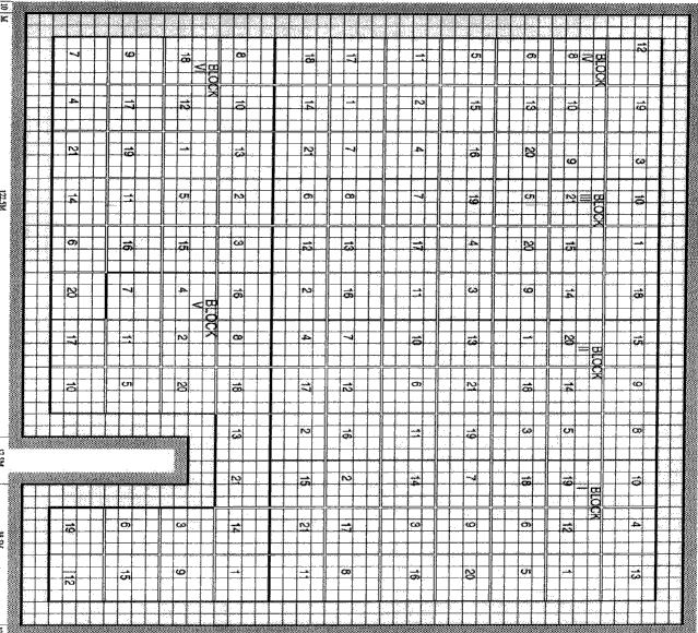
TRIAL DESIGN
Statistical design: Randomized complete block design
No. of replications (blocks): 5 replications
No. of treatments (provenances): 21
Plot size (No. of trees in plot): 16
Demarcation (blocks, plots): Two rows of Neem trees of Chamwino provenance are used
as demarcation
PROVENANCES TESTED
Marked provenances have been included in the trial:
Nazir Hat (01/BGD/Naz) |
Annur (06/IND/Ann) |
Vientiane (11/LAO/Vie) |
Tibbi Laran (16/PAK/Tib) |
Ban Bo (21/THA/Bo) |
Chapai Nawabganj (02/BGD/Cha) |
Ghaati Subramanya (07/IND/Gha) |
Yezin (12/MYA/Yez) |
Multan (17/PAK/Mul) |
Doi Tao (22/THA/Doi) |
|
Mandore (03/IND/Man) |
Sagar Chanatoria (08/IND/Sag) |
Myene (13/MYA/Mye) |
Kuliyapitiya (18/SRL/Kul) |
Sunyani (23/GHA/Sun) |
|
Chitradurga (04/IND/Chi) |
Balharshah (09/IND/Bal) |
Lamahi (14/NEP/Lam) |
Tung Luang (19/THA/Thu) |
Bandia (24/SEN/Ban) |
|
Allahabad (05/IND/All) |
Ramannaguda (10/IND/Ram) |
Geta (15/NEP/Get) |
Ban Nong Rong 1 (20/THA/Non) |
Chamwino (25/TAN/Cha) |
Names of any local provenances included in the trial:
PROTECTION STATUS:
Status (describe any disturbances/damages): It is crucial to keep cattle away from the area,
and to protect it from fires
Guarding (permanent, regular, none): Permanent
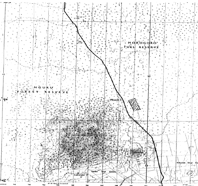
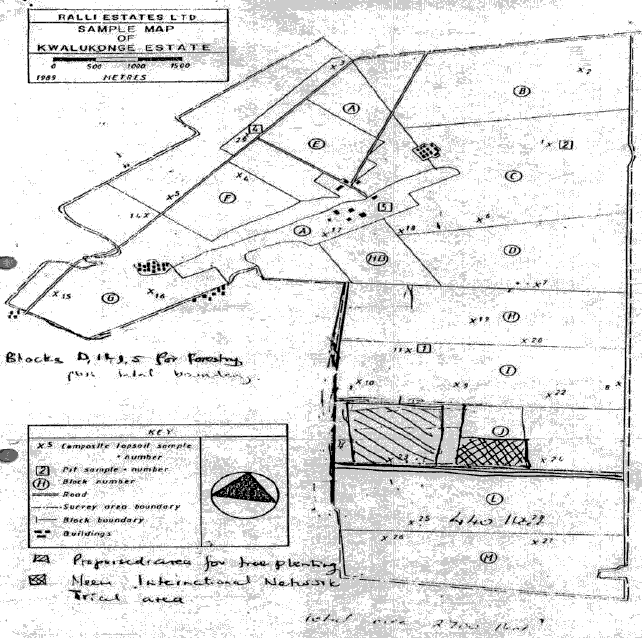
Location map Chamwino, Tanzania 1
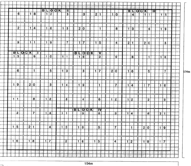
Trial design map Chamwino, Tanzania 1
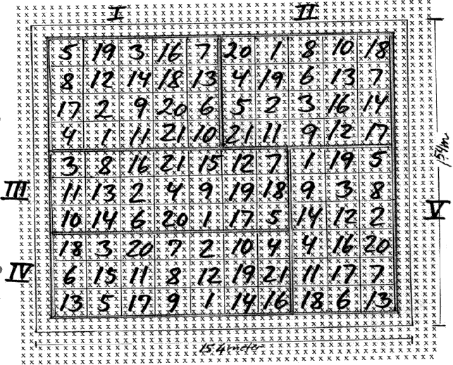
Legend:
|
Local No.: |
International No.: |
Local No.: |
International No.: |
Local No.: |
International No.: |
|
1 |
12/MYA/Yes |
8 |
07/IND/Gha |
15 |
16/PAK/Tib |
|
2 |
21/THA/Bo |
9 |
03/IND/Man |
16 |
17/PAK/Mul |
|
3 |
20/THA/Non |
10 |
05/IND/All |
17 |
15NEP/Get |
|
4 |
22/THA/Doi |
11 |
06/IND/Ann |
18 |
14/NEP/Lam |
|
5 |
11/LAO/Vie |
12 |
23/GHA/Sun |
19 |
09/IND/Bal |
|
6 |
25/TAN/Cha |
13 |
10/IND/Ram |
20 |
18/SRL/Kul |
|
7 |
04/IND/Chi |
14 |
08/IND/Sag |
21 |
24/SEN/Ban |
LOCATION
Province: Morogoro
District: Morogoro district
Latitude (degrees and minutes): 06°40'S
Longitude (degrees and minutes): 37°39'E
Altitude (m above sea level): 475
Managing office/institution: Forest and Beekeeping Department, National Tree Seed Programme
Owner: do
User(s): do
Distance to nearest office responsible for management of the trial (km): 12 km
Distance to nearest villages/towns (km): 0.5 km
Number of inhabitants in the nearest villages/towns: 1000
Type of area (e.g. research station, managed forest, etc.): Fuelwood Forest Reserve
CLIMATE
Nearest weather station:
Name of the station: Tungi Sisal Estate
Latitude (degrees and minutes): 6o39'S
Longitude (degrees and minutes): 37o41'E
Altitude (m a.s.l.): 503 m
|
Climatic data1 |
Jan. |
Feb. |
Mar. |
Apr. |
May |
June |
July |
Aug. |
Sep. |
Oct. |
Nov. |
Dec. |
Year |
|
Rainfall (mm) |
123 |
90 |
132 |
154 |
64 |
19 |
15 |
11 |
14 |
29 |
48 |
94 |
793 mm |
|
Temp. mean (_C) |
26 |
26 |
26 |
25 |
23 |
22 |
21 |
22 |
23 |
24 |
26 |
26 |
24°C |
|
Temp. mean max.2 (_C) |
|||||||||||||
|
Temp. mean min.3 (_C) |
|||||||||||||
|
Evapotranspiration4 (mm) |
1 Period of observations:..40...(specify years) 2 Average of daily maximum temperatures
3 Average of daily minimum temperatures 4 Potential evapotranspiration (ETP) - Penman's formula
Rainy season:
|
Number/type of seasons: |
one |
two |
X |
even/irregular |
Period(s): (specify months)
Length of rainy season:
No. of intermediate days: (pre- and posthumid period of the growing season)
No. of wet days: 180 (growing season)
Number of dry months per year (< 50 mm rain/month): 6
Frost (number of days/year): None
Prevailing winds (direction, period, speed): West -> East (Sept. - Dec.)
TOPOGRAPHY (slope) of trial site
|
x |
Flat/gentle (0-8%) |
Intermediate (9-30%) |
Steep (>30%) |
|
GENERAL SOIL DESCRIPTION |
|
Soil texture |
Soil depth |
Soil drainage/ Waterlogging |
Gravel content, topsoil | ||||
|
1. Light/sandy |
X |
1. Shallow (< 50 cm) |
1. Well drained |
X |
1. None (< 15 %) |
||
|
2. Medium/loamy |
2. Deep (50-100 cm) |
X |
2. Seasonal |
2. Gravelly (15-35 %) |
|||
|
3. Heavy/clayey |
X |
3. Very deep (> 100 cm) |
3. Permanent |
3. Stony (> 35 %) |
|||
|
Organic matter content |
Reaction (pH) |
Soil salinity |
Groundwater | ||||
|
1. Poor (< 2 % DM) |
1. Acid (pH < 6.5) |
1. None |
1. Shallow (< 50 cm) |
||||
|
2. Medium (2-5 % DM) |
2. Neutral (6.5-7.5) |
2. Moderate |
2. Deep (50 - 150 cm) |
||||
|
3. Rich (> 5 %) |
3. Alkaline (pH> 7.5) |
3. High |
3. Very deep (>150 cm) |
||||
Specify soil unit, soil association and phases (subdivisions of soil units) according to the Soil map of the world (FAO-Unesco 1971-1979), if known:
VEGETATION
Natural (original) vegetation type: Miombo woodland forest
Dominant natural (original) genera/species: Sclerocarya birrea, Combretum spp., Acacia spp.
Land use history: Severely degraded by charcoal burners
Apparent major problems of site (pests, diseases, etc):.Nil
Economic data, viz. farm gate prices for fodder, fuel wood, small size timber,
extractives, and other minor produce: NA
TRIAL ESTABLISHMENT AND MANAGEMENT
Year and month of establishment: March 1996
Area (ha): 2.94 ha
Initial spacing (m x m): 3.5 x 3.5
Soil preparation (time, method/intensity): Felling of trees manually. Clearing of shrubs and crowns done manually and thereafter put in a ring around the area. Remaining debris burned. Mechanical ripping and destumping by bulldozer then ploughed and harrowed by tractor
Planting method(age of seedlings, type): Container seedlings
Beating up (time, %): Less than 5 %
Irrigation (time, amount): Nil
Fertilization (time, type, amount): None
Weeding (time, intensity): Regularly twice a year for first three years after establishment,
then once a year.
Thinning (time, intensity): None
Firelines: Maintained regularly
TRIAL DESIGN
Statistical design: Randomized complete block design
No. of replications (blocks): 6 replications
No. of treatments (provenances): 21
Plot size (No. of trees in plot): 16
Demarcation (blocks, plots): Two rows of Neem (Chamwino) as border between plots
PROVENANCES TESTED
Marked provenances have been included in the trial:
|
Nazir Hat (01/BGD/Naz) |
Annur (06/IND/Ann) |
Vientiane (11/LAO/Vie) |
Tibbi Laran (16/PAK/Tib) |
Ban Bo (21/THA/Bo) |
|
Chapai Nawabganj (02/BGD/Cha) |
Ghaati Subramanya (07/IND/Gha) |
Yezin (12/MYA/Yez) |
Multan (17/PAK/Mul) |
Doi Tao (22/THA/Doi) |
|
Mandore (03/IND/Man) |
Sagar Chanatoria (08/IND/Sag) |
Myene (13/MYA/Mye) |
Kuliyapitiya (18/SRL/Kul) |
Sunyani (23/GHA/Sun) |
|
Chitradurga (04/IND/Chi) |
Balharshah (09/IND/Bal) |
Lamahi (14/NEP/Lam) |
Tung Luang (19/THA/Thu) |
Bandia (24/SEN/Ban) |
|
Allahabad (05/IND/All) |
Ramannaguda (10/IND/Ram) |
Geta (15/NEP/Get) |
Ban Nong Rong 1 (20/THA/Non) |
Chamwino (25/TAN/Cha) |
Names of any local provenances included in the trial: Chamwino (25/TAN/Cha)
PROTECTION STATUS:
Status (describe any disturbances/damages): The trial is still intact apart from some minor damages.
Monkeys climbing the trees cause some damage by breaking the branches
Guarding (permanent, regular, none): Permanently
a)
b)
Legend:
|
Local No.: |
International No.: |
Local No.: |
International No.: |
Local No.: |
International No.: |
|
1 |
12/MYA/Yes |
8 |
07/IND/Gha |
15 |
16/PAK/Tib |
|
2 |
21/THA/Bo |
9 |
03/IND/Man |
16 |
17/PAK/Mul |
|
3 |
20/THA/Non |
10 |
05/IND/All |
17 |
15NEP/Get |
|
4 |
22/THA/Doi |
11 |
06/IND/Ann |
18 |
14/NEP/Lam |
|
5 |
11/LAO/Vie |
12 |
23/GHA/Sun |
19 |
09/IND/Bal |
|
6 |
25/TAN/Cha |
13 |
10/IND/Ram |
20 |
18/SRL/Kul |
|
7 |
04/IND/Chi |
14 |
08/IND/Sag |
21 |
24/SEN/Ban |
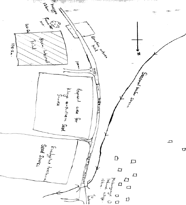
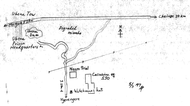
LOCATION
Province: Morogoro
District: Bagamoyo district
Latitude (degrees and minutes): 06°36'S
Longitude (degrees and minutes): 38°09'E
Altitude (m above sea level): 305
Managing office/institution: Forest and Beekeeping Department, National Tree Seed Programme
Owner: Ubena Prison
User(s): National Tree Seed Programme
Distance to nearest office responsible for management of the trial (km): 54 km
Distance to nearest villages/towns (km): 3-4 km south of the highway between Morogoro and Chalinze
Number of inhabitants in the nearest villages/towns: 1500
Type of area (e.g. research station, managed forest, etc.): Private
CLIMATE
Nearest weather station:
Name of the station: Ubena Zomozi
Latitude (degrees and minutes): 6o36S
Longitude (degrees and minutes): 38o09'E
Altitude (m a.s.l.): 842 m
|
Climatic data1 |
Jan. |
Feb. |
Mar. |
Apr. |
May |
June |
July |
Aug. |
Sep. |
Oct. |
Nov. |
Dec. |
Year |
|
Rainfall (mm) |
81.5 |
67.7 |
139.7 |
133.2 |
89.6 |
25.0 |
10.8 |
11.3 |
55.3 |
37.8 |
101.0 |
89.5 |
842.4 mm |
|
Temp. mean (_C) |
26.94 |
27.04 |
26.98 |
25.93 |
24.82 |
23.61 |
22.96 |
23.27 |
23.87 |
24.92 |
26.02 |
26.79 |
25.26°C |
|
Temp. mean max.2 (_C) |
|||||||||||||
|
Temp. mean min.3 (_C) |
|||||||||||||
|
Evapotranspiration4 (mm) |
1 Period of observations:....> 6..(specify years) 2 Average of daily maximum temperatures
3 Average of daily minimum temperatures 4 Potential evapotranspiration (ETP) - Penman's formula
Rainy season:
|
Number/type of seasons: |
one |
two |
X |
even/irregular |
Period(s): (specify months)
Length of rainy season:
No. of intermediate days: 160 (pre- and posthumid period of the growing season)
No. of wet days: 150 (growing season)
Number of dry months per year (< 50 mm rain/month): 4
Frost (number of days/year): None
Prevailing winds (direction, period, speed): East -> West
TOPOGRAPHY (slope) of trial site
|
x |
Flat/gentle (0-8%) |
Intermediate (9-30%) |
Steep (>30%) |
|
GENERAL SOIL DESCRIPTION |
|
Soil texture |
Soil depth |
Soil drainage/ Waterlogging |
Gravel content, topsoil | ||||
|
1. Light/sandy |
1. Shallow (< 50 cm) |
1. Well drained |
x |
1. None (< 15 %) |
|||
|
2. Medium/loamy |
2. Deep (50-100 cm) |
x |
2. Seasonal |
2. Gravelly (15-35 %) |
|||
|
3. Heavy/clayey |
3. Very deep (> 100 cm) |
3. Permanent |
3. Stony (> 35 %) |
||||
|
Organic matter content |
Reaction (pH) |
Soil salinity |
Groundwater | ||||
|
1. Poor (< 2 % DM) |
x |
1. Acid (pH < 6.5) |
1. None |
x |
1. Shallow (< 50 cm) |
||
|
2. Medium (2-5 % DM) |
2. Neutral (6.5-7.5) |
2. Moderate |
2. Deep (50 - 150 cm) |
||||
|
3. Rich (> 5 %) |
3. Alkaline (pH> 7.5) |
3. High |
3. Very deep (>150 cm) |
x | |||
Specify soil unit, soil association and phases (subdivisions of soil units) according to the Soil map of the world (FAO-Unesco 1971-1979), if known:
VEGETATION
Natural (original) vegetation type: Miombo woodland
Dominant natural (original) genera/species: Acacia spp.., Sclerocarya birrea
Land use history: Miombo woodland forest which has been degraded due to charcoal making and fuelwood collection and cattle grazing and tsetsefly eradication
Apparent major problems of site (pests, diseases, etc): Monkeys break branches on the Neem trees.
Economic data, viz. farm gate prices for fodder, fuel wood, small size timber,
extractives, and other minor produce: NA
TRIAL ESTABLISHMENT AND MANAGEMENT
Year and month of establishment: April 1996
Area (ha): 2.37ha
Initial spacing (m x m): 3.5 x 3.5 m
Soil preparation (time, method/intensity): Manual clearing and uprooting of tree stumps, ploughing and harrowing by tractor.
Planting method (age of seedlings, type): Containerized in polythene bags
Beating up (time, %): None
Irrigation (time, amount): Nil
Fertilization (time, type, amount): None
Weeding (time, intensity): Regularly twice a year for the first three years.
Once a year in subsequent years.
Thinning (time, intensity): None
Firelines:
TRIAL DESIGN
Statistical design: Randomized incomplete block design
No. of replications (blocks): 5 replications
No. of treatments (provenances): 20
Plot size (No. of trees in plot): 16
Demarcation (blocks, plots): Two border rows of Neem (Chamwino) between plots
PROVENANCES TESTED
Marked provenances have been included in the trial:
|
Nazir Hat (01/BGD/Naz) |
Annur (06/IND/Ann) |
Vientiane (11/LAO/Vie) |
Tibbi Laran (16/PAK/Tib) |
Ban Bo (21/THA/Bo) |
|
Chapai Nawabganj (02/BGD/Cha) |
Ghaati Subramanya (07/IND/Gha) |
Yezin (12/MYA/Yez) |
Multan (17/PAK/Mul) |
Doi Tao (22/THA/Doi) |
|
Mandore (03/IND/Man) |
Sagar Chanatoria (08/IND/Sag) |
Myene (13/MYA/Mye) |
Kuliyapitiya (18/SRL/Kul) |
Sunyani (23/GHA/Sun) |
|
Chitradurga (04/IND/Chi) |
Balharshah (09/IND/Bal) |
Lamahi (14/NEP/Lam) |
Tung Luang (19/THA/Thu) |
Bandia (24/SEN/Ban) |
|
Allahabad (05/IND/All) |
Ramannaguda (10/IND/Ram) |
Geta (15/NEP/Get) |
Ban Nong Rong 1 (20/THA/Non) |
Chamwino (25/TAN/Cha) |
Names of any local provenances included in the trial: Chamwino (25/TAN/Cha)
PROTECTION STATUS:
Status (describe any disturbances/damages): Needs protection against monkeys
Guarding (permanent, regular, none): Permanent
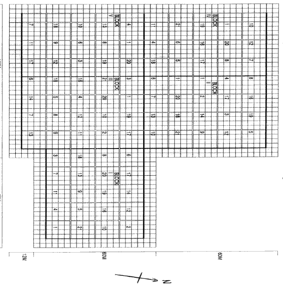
Legend:
|
Local No.: |
International No.: |
Local No.: |
International No.: |
Local No.: |
International No.: |
|
1 |
12/MYA/Yes |
8 |
07/IND/Gha |
15 |
16/PAK/Tib |
|
2 |
21/THA/Bo |
9 |
03/IND/Man |
16 |
17/PAK/Mul |
|
3 |
20/THA/Non |
10 |
05/IND/All |
17 |
15NEP/Get |
|
4 |
22/THA/Doi |
11 |
06/IND/Ann |
18 |
14/NEP/Lam |
|
5 |
11/LAO/Vie |
12 |
23/GHA/Sun |
19 |
09/IND/Bal |
|
6 |
25/TAN/Cha |
13 |
10/IND/Ram |
20 |
18/SRL/Kul |
|
7 |
04/IND/Chi |
14 |
08/IND/Sag |
21 |
24/SEN/Ban |
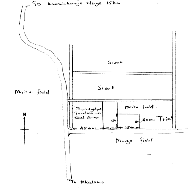
LOCATION
Province: Tanga
District: Mombo Lushoto district
Latitude (degrees and minutes): 04°57'S
Longitude (degrees and minutes): 30°31'E
Altitude (m above sea level): 488
Managing office/institution: National Tree Seed Programme, Morogoro
Owner: Ralli Sisal Estate
User(s): NTSP/Ralli Sisal Estate
Distance to nearest office responsible for management of the trial (km):
Distance to nearest villages/towns (km): 20 km from Mombo town on the way to Mkalamo village
Number of inhabitants in the nearest villages/towns:
Type of area (e.g. research station, managed forest, etc.): Private estate
CLIMATE
Nearest weather station:
Name of the station: Kwalukonge sisal estate office (5km from site)
Latitude (degrees and minutes): 4o57'S
Longitude (degrees and minutes): 38o42'E
Altitude (m a.s.l.): 213
|
Climatic data1 |
Jan. |
Feb. |
Mar. |
Apr. |
May |
June |
July |
Aug. |
Sep. |
Oct. |
Nov. |
Dec. |
Year |
|
Rainfall (mm) |
54.3 |
49.6 |
79.5 |
127.7 |
145.7 |
30 |
23.5 |
18.5 |
34.5 |
31.8 |
69.9 |
73.6 |
738.6 mm |
|
Temp. mean (_C) |
26 |
26 |
26 |
24 |
23 |
22 |
21 |
21 |
22 |
23 |
25 |
25 |
|
|
Temp. mean max.2 (_C) |
|||||||||||||
|
Temp. mean min.3 (_C) |
|||||||||||||
|
Evapotranspiration4 (mm) |
1 Period of observations:.....7....(specify years) 2 Average of daily maximum temperatures
3 Average of daily minimum temperatures 4 Potential evapotranspiration (ETP) - Penman's formula
Rainy season:
|
Number/type of seasons: |
x |
one |
two |
even/irregular |
Period(s): March-April-May (specify months)
Length of rainy season:
No. of intermediate days: (pre- and posthumid period of the growing season)
No. of wet days: (growing season)
Number of dry months per year (< 50 mm rain/month): 6
Frost (number of days/year): None
Prevailing winds (direction, period, speed): South -> North (Sept.-Oct.)
TOPOGRAPHY (slope) of trial site
|
x |
Flat/gentle (0-8%) |
Intermediate (9-30%) |
Steep (>30%) |
|
GENERAL SOIL DESCRIPTION |
|
Soil texture |
Soil depth |
Soil drainage/ Waterlogging |
Gravel content, topsoil | ||||
|
1. Light/sandy |
1. Shallow (< 50 cm) |
1. Well drained |
X |
1. None (< 15 %) |
|||
|
2. Medium/loamy |
X |
2. Deep (50-100 cm) |
2. Seasonal |
2. Gravelly (15-35 %) |
|||
|
3. Heavy/clayey |
3. Very deep (> 100 cm) |
X |
3. Permanent |
3. Stony (> 35 %) |
|||
|
Organic matter content |
Reaction (pH) |
Soil salinity |
Groundwater | ||||
|
1. Poor (< 2 % DM) |
1. Acid (pH < 6.5) |
1. None |
1. Shallow (< 50 cm) |
||||
|
2. Medium (2-5 % DM) |
2. Neutral (6.5-7.5) |
2. Moderate |
2. Deep (50 - 150 cm) |
||||
|
3. Rich (> 5 %) |
3. Alkaline (pH> 7.5) |
3. High |
3. Very deep (>150 cm) |
||||
Specify soil unit, soil association and phases (subdivisions of soil units) according to the Soil map of the world (FAO-Unesco 1971-1979), if known:
VEGETATION
Natural (original) vegetation type: Not known. Since it was cleared, it has been planted with sisal for more than 20 years
Dominant natural (original) genera/species: Acacia spp. are found scattered around the plantation
Land use history: Cultivated with Sisal for more than 20 years and converted to maize farm before cleared to be planted with trees
Apparent major problems of site (pests, diseases, etc):.Nil
Economic data, viz. farm gate prices for fodder, fuel wood, small size timber,
extractives, and other minor produce: NA
TRIAL ESTABLISHMENT AND MANAGEMENT
Year and month of establishment: April 1996
Area (ha): 2.73 ha
Initial spacing (m x m): 3.5 x 3.5
Soil preparation (time, method/intensity): Bulldozing only, no soil preparation
Planting method (age of seedlings, type): 5-8 months
Beating up (time, %): None
Irrigation (time, amount): None
Fertilization (time, type, amount): None
Weeding (time, intensity): Once a year since establishment
Thinning (time, intensity): None
Firelines: Cleared and maintained throughout the year
TRIAL DESIGN
Statistical design: Randomized incomplete block design
No. of replications (blocks): 5 replications
No. of treatments (provenances): 21
Plot size (No. of trees in plot): 21 (block 5 only 16)
Demarcation (blocks, plots):
PROVENANCES TESTED
Marked provenances have been included in the trial:
|
Nazir Hat (01/BGD/Naz) |
Annur (06/IND/Ann) |
Vientiane (11/LAO/Vie) |
Tibbi Laran (16/PAK/Tib) |
Ban Bo (21/THA/Bo) |
|
Chapai Nawabganj (02/BGD/Cha) |
Ghaati Subramanya (07/IND/Gha) |
Yezin (12/MYA/Yez) |
Multan (17/PAK/Mul) |
Doi Tao (22/THA/Doi) |
|
Mandore (03/IND/Man) |
Sagar Chanatoria (08/IND/Sag) |
Myene (13/MYA/Mye) |
Kuliyapitiya (18/SRL/Kul) |
Sunyani (23/GHA/Sun) |
|
Chitradurga (04/IND/Chi) |
Balharshah (09/IND/Bal) |
Lamahi (14/NEP/Lam) |
Tung Luang (19/THA/Thu) |
Bandia (24/SEN/Ban) |
|
Allahabad (05/IND/All) |
Ramannaguda (10/IND/Ram) |
Geta (15/NEP/Get) |
Ban Nong Rong 1 (20/THA/Non) |
Chamwino (25/TAN/Cha) |
Names of any local provenances included in the trial: Chamwino (25/TAN/Cha)
PROTECTION STATUS:
Status (describe any disturbances/damages): Rains made area unaccessable for longer periods
Guarding (permanent, regular, none): Permanently
a)
b)
Legend:
|
Local No.: |
International No.: |
Local No.: |
International No.: |
Local No.: |
International No.: |
|
1 |
12/MYA/Yes |
8 |
07/IND/Gha |
15 |
16/PAK/Tib |
|
2 |
21/THA/Bo |
9 |
03/IND/Man |
16 |
17/PAK/Mul |
|
3 |
20/THA/Non |
10 |
05/IND/All |
17 |
15NEP/Get |
|
4 |
22/THA/Doi |
11 |
06/IND/Ann |
18 |
14/NEP/Lam |
|
5 |
11/LAO/Vie |
12 |
23/GHA/Sun |
19 |
09/IND/Bal |
|
6 |
25/TAN/Cha |
13 |
10/IND/Ram |
20 |
18/SRL/Kul |
|
7 |
04/IND/Chi |
14 |
08/IND/Sag |
21 |
24/SEN/Ban |
![]()
![]()
![]()