![]()
![]()
![]()
LOCATION
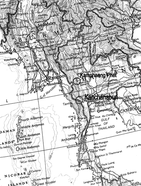
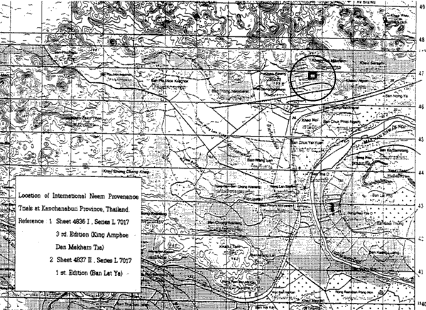
Province: Kanchanaburi Province, Western Thailand
District: Muang
Latitude (degrees and minutes): 14° N
Longitude (degrees and minutes): 99°30'E
Altitude (m above sea level): 30 mas
Managing office/institution: Silviculture Research Centre 3, Royal Forest Department
Owner: Kanchanaburi Horticultural Research Station
User(s): do
Distance to nearest office responsible for management of the trial (km): 10 km
Distance to nearest villages/towns (km): 1 km
Number of inhabitants in the nearest villages/towns: 10,000
Type of area (e.g. research station, managed forest, etc.): Research Station
CLIMATE
Nearest weather station:
Name of the station: Lampao - Lamsai Experiment Station, RFD
Latitude (degrees and minutes): 13°58N
Longitude (degrees and minutes): 99°18'N
Altitude (m a.s.l.): 45
Climatic data1 |
Jan. |
Feb. |
Mar. |
Apr. |
May |
June |
July |
Aug. |
Sep. |
Oct. |
Nov. |
Dec. |
Year |
Rainfall (mm) |
0.3 |
9.3 |
29.0 |
86.2 |
134.3 |
106.9 |
95.5 |
97.6 |
191.3 |
174.5 |
93.9 |
1.3 |
1020.1 |
Temp. mean (_C) |
26.6 |
29.3 |
32.2 |
33.1 |
32.5 |
30.9 |
31.1 |
30.1 |
39.1 |
27.7 |
27.7 |
25.4 |
29.9 |
Temp. mean max.2 (_C) |
33.6 |
36.1 |
29.3 |
39.2 |
37.8 |
35.4 |
36.0 |
34.4 |
34.7 |
32.4 |
32.4 |
31.0 |
35.3 |
Temp. mean min.3 (_C) |
19.6 |
22.5 |
25.0 |
26.9 |
27.1 |
26.3 |
26.2 |
25.8 |
25.5 |
22.9 |
22.9 |
19.7 |
24.4 |
Evapotranspiration4 (mm) |
73.6 |
73.6 |
76.3 |
78.9 |
82.1 |
84.5 |
81.1 |
81.7 |
85.3 |
88.9 |
88.9 |
81.6 |
976.5 |
1 Period of observations:.1978-1987....(specify years) 2 Average of daily maximum temperatures
3 Average of daily minimum temperatures 4 Potential evapotranspiration (ETP) - Penman's formula
Rainy season:
Number/type of seasons: |
x |
one |
two |
even/irregular |
Period(s): July - September (specify months)
Length of rainy season:
No. of intermediate days: 90 (pre- and posthumid period of the growing season)
No. of wet days: 68.1 (growing season)
Number of dry months per year (< 50 mm rain/month): 5
Frost (number of days/year): nil
Prevailing winds (direction, period, speed): Westerly wind, April-October
TOPOGRAPHY (slope) of trial site
/ |
Flat/gentle (0-8%) |
Intermediate (9-30%) |
Steep (>30%) |
GENERAL SOIL DESCRIPTION |
Soil texture |
Soil depth |
Soil drainage/ Waterlogging |
Gravel content, topsoil | ||||
1. Light/sandy |
X |
1. Shallow (< 50 cm) |
X |
1. Well drained |
1. None (< 15 %) |
||
2. Medium/loamy |
2. Deep (50-100 cm) |
2. Seasonal |
X |
2. Gravelly (15-35 %) |
X | ||
3. Heavy/clayey |
3. Very deep (> 100 cm) |
3. Permanent |
3. Stony (> 35 %) |
||||
Organic matter content |
Reaction (pH) |
Soil salinity |
Groundwater | ||||
1. Poor (< 2 % DM) |
X |
1. Acid (pH < 6.5) |
1. None |
X |
1. Shallow (< 50 cm) |
||
2. Medium (2-5 % DM) |
2. Neutral (6.5-7.5) |
2. Moderate |
2. Deep (50 - 150 cm) |
||||
3. Rich (> 5 %) |
3. Alkaline (pH> 7.5) |
X |
3. High |
3. Very deep (>150 cm) |
X | ||
Specify soil unit, soil association and phases (subdivisions of soil units) according to the Soil map of the world (FAO-Unesco 1971-1979), if known:
VEGETATION
Natural (original) vegetation type: Dry Deciduous Forest
Dominant natural (original) genera/species: Azadirachta indica, Sindora sianensis, Cassis fistula, Pterocarpus macrocarpus
Land use history: Cattle raising
Apparent major problems of site (pests, diseases, etc):.
Economic data, viz. farm gate prices for fodder, fuel wood, small size timber,
extractives, and other minor produce:
TRIAL ESTABLISHMENT AND MANAGEMENT
Year and month of establishment: August 1997
Area (ha): 4 ha
Initial spacing (m x m): 5 x 5 m
Soil preparation (time, method/intensity):
Planting method(age of seedlings, type):
Beating up (time, %):
Irrigation (time, amount):
Fertilization (time, type, amount):
Weeding (time, intensity):
Thinning (time, intensity):
Firelines:
TRIAL DESIGN
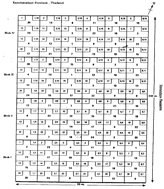
Statistical design: Randomized complete block design
No. of replications (blocks): 4 replications
No. of treatments (provenances): 24
Plot size (No. of trees in plot): 25
Demarcation (blocks, plots):
PROVENANCES TESTED
Marked provenances have been included in the trial:
Nazir Hat (01/BGD/Naz) |
Annur (06/IND/Ann) |
Vientiane (11/LAO/Vie) |
Tibbi Laran (16/PAK/Tib) |
Ban Bo (21/THA/Bo) |
Chapai Nawabganj (02/BGD/Cha) |
Ghaati Subramanya (07/IND/Gha) |
Yezin (12/MYA/Yez) |
Multan (17/PAK/Mul) |
Doi Tao (22/THA/Doi) |
Mandore (03/IND/Man) |
Sagar Chanatoria (08/IND/Sag) |
Myene (13/MYA/Mye) |
Kuliyapitiya (18/SRL/Kul) |
Sunyani (23/GHA/Sun) |
Chitradurga (04/IND/Chi) |
Balharshah (09/IND/Bal) |
Lamahi (14/NEP/Lam) |
Tung Luang (19/THA/Thu) |
Bandia (24/SEN/Ban) |
Allahabad (05/IND/All) |
Ramannaguda (10/IND/Ram) |
Geta (15/NEP/Get) |
Ban Nong Rong 1 (20/THA/Non) |
Chamwino (25/TAN/Cha) |
Names of any local provenances included in the trial: Ban Nong Hoi, Khao Luang
PROTECTION STATUS:
Status (describe any disturbances/damages):
Guarding (permanent, regular, none):
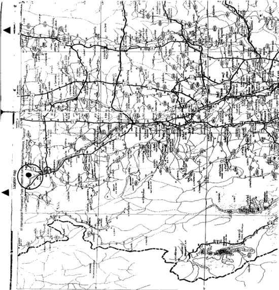
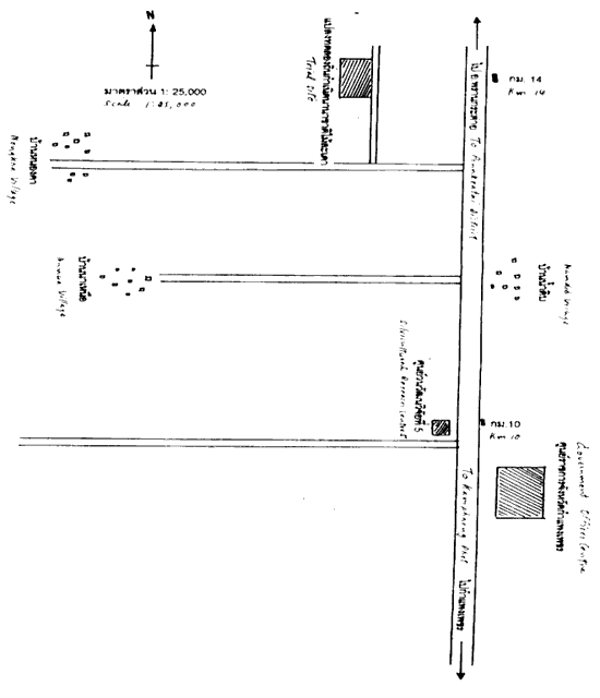
Location map - Kanchanaburi, Thailand 1
a)
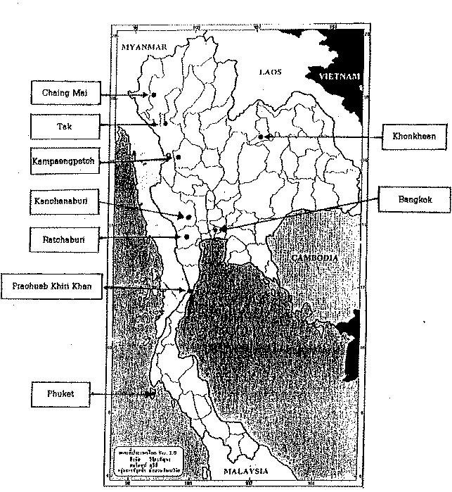
Location map - Kanchanaburi, Thailand 1
b)
Design map - Kanchanaburi, Thailand 1
a)
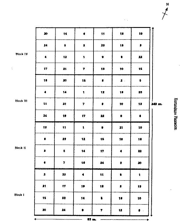
Design map - Kanchanaburi, Thailand 1
b)
LOCATION
Province: Kakmphaeng Phet
District: Muang
Latitude (degrees and minutes): 16°30'N
Longitude (degrees and minutes): 99°20'E
Altitude (m above sea level): 100
Managing office/institution: Silvicultural Research Centre 5
Owner: RFD
User(s): do
Distance to nearest office responsible for management of the trial (km): 1
Distance to nearest villages/towns (km): 5
Number of inhabitants in the nearest villages/towns: 5,000
Type of area (e.g. research station, managed forest, etc.): Research Station
CLIMATE
Nearest weather station:
Name of the station: Kamphaeng Phet Tree Improvement Station, RFD (SRC 5)
Latitude (degrees and minutes): 16°30'N
Longitude (degrees and minutes): 99°20'E
Altitude (m a.s.l.): 100
Climatic data1 |
Jan. |
Feb. |
Mar. |
Apr. |
May |
June |
July |
Aug. |
Sep. |
Oct. |
Nov. |
Dec. |
Year |
Rainfall (mm) |
0.0 |
17.8 |
2.1 |
84.4 |
319 |
253.1 |
184.7 |
274.9 |
305.1 |
245.4 |
108.5 |
6.3 |
1801.3 |
Temp. mean (_C) |
24 |
27.2 |
29.3 |
30.6 |
30.5 |
29.3 |
28.7 |
29 |
28.7 |
27.8 |
26.5 |
23.8 |
28 |
Temp. mean max.2 (_C) |
29.l |
33.1 |
34.4 |
35.3 |
34.1 |
32.2 |
31.3 |
31.8 |
31.5 |
30.4 |
29.5 |
28.7 |
31.8 |
Temp. mean min.3 (_C) |
18.8 |
21.3 |
24.2 |
25.9 |
26.8 |
28.4 |
26.1 |
26.1 |
25.9 |
25.2 |
23.4 |
18.8 |
24.1 |
Evapotranspiration4 (mm) |
1 Period of observations:..1978-1987.......(specify years) 2 Average of daily maximum temperatures
3 Average of daily minimum temperatures 4 Potential evapotranspiration (ETP) - Penman's formula
Rainy season:
Number/type of seasons: |
1 |
one |
two |
even/irregular |
Period(s): July-September (specify months)
Length of rainy season:
No. of intermediate days: 90 (pre- and posthumid period of the growing season)
No. of wet days: 60.4 (growing season)
Number of dry months per year (< 50 mm rain/month): 5
Frost (number of days/year): none
Prevailing winds (direction, period, speed): westerly wind, April-October
TOPOGRAPHY (slope) of trial site
Flat/gentle (0-8%) |
Intermediate (9-30%) |
Steep (>30%) |
GENERAL SOIL DESCRIPTION |
Soil texture |
Soil depth |
Soil drainage/ Waterlogging |
Gravel content, topsoil | ||||
1. Light/sandy |
1. Shallow (< 50 cm) |
1. Well drained |
1. None (< 15 %) |
||||
2. Medium/loamy |
2. Deep (50-100 cm) |
2. Seasonal |
2. Gravelly (15-35 %) |
||||
3. Heavy/clayey |
3. Very deep (> 100 cm) |
3. Permanent |
3. Stony (> 35 %) |
||||
Organic matter content |
Reaction (pH) |
Soil salinity |
Groundwater | ||||
1. Poor (< 2 % DM) |
1. Acid (pH < 6.5) |
1. None |
1. Shallow (< 50 cm) |
||||
2. Medium (2-5 % DM) |
2. Neutral (6.5-7.5) |
2. Moderate |
2. Deep (50 - 150 cm) |
||||
3. Rich (> 5 %) |
3. Alkaline (pH> 7.5) |
3. High |
3. Very deep (>150 cm) |
||||
Specify soil unit, soil association and phases (subdivisions of soil units) according to the Soil map of the world (FAO-Unesco 1971-1979), if known:
VEGETATION
Natural (original) vegetation type: Moist deciduous forest
Dominant natural (original) genera/species: Dipterocarpus alatus, Pterocarpus macrocarpus, Afzalia xylocarpa
Land use history: Natural reserved forest
Apparent major problems of site (pests, diseases, etc):.
Economic data, viz. farm gate prices for fodder, fuel wood, small size timber,
extractives, and other minor produce:
TRIAL ESTABLISHMENT AND MANAGEMENT
Year and month of establishment: August 1997
Area (ha): 4 ha
Initial spacing (m x m): 5 x 5
Soil preparation (time, method/intensity):
Planting method(age of seedlings, type):
Beating up (time, %):
Irrigation (time, amount):
Fertilization (time, type, amount):
Weeding (time, intensity):
Thinning (time, intensity):
Firelines:
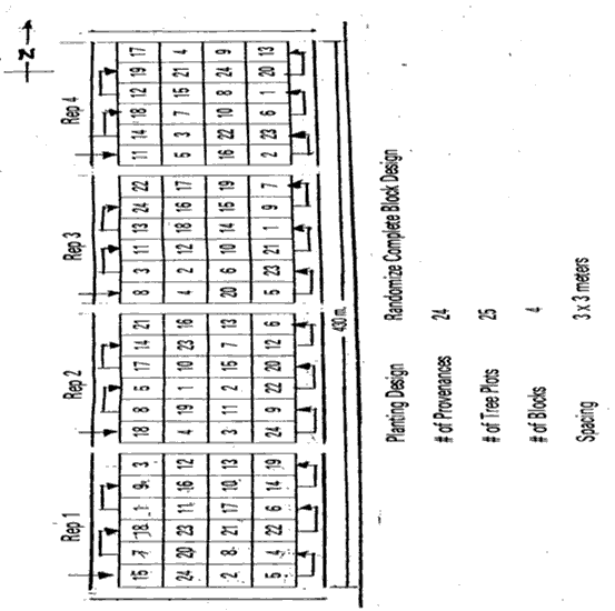
TRIAL DESIGN
Statistical design: Randomized complete block design
No. of replications (blocks): 4 replications
No. of treatments (provenances): 23
Plot size (No. of trees in plot): 24
Demarcation (blocks, plots):
PROVENANCES TESTED
Marked provenances have been included in the trial:
Nazir Hat (01/BGD/Naz) |
Annur (06/IND/Ann) |
Vientiane (11/LAO/Vie) |
Tibbi Laran (16/PAK/Tib) |
Ban Bo (21/THA/Bo) |
Chapai Nawabganj (02/BGD/Cha) |
Ghaati Subramanya (07/IND/Gha) |
Yezin (12/MYA/Yez) |
Multan (17/PAK/Mul) |
Doi Tao (22/THA/Doi) |
Mandore (03/IND/Man) |
Sagar Chanatoria (08/IND/Sag) |
Myene (13/MYA/Mye) |
Kuliyapitiya (18/SRL/Kul) |
Sunyani (23/GHA/Sun) |
Chitradurga (04/IND/Chi) |
Balharshah (09/IND/Bal) |
Lamahi (14/NEP/Lam) |
Tung Luang (19/THA/Thu) |
Bandia (24/SEN/Ban) |
Allahabad (05/IND/All) |
Ramannaguda (10/IND/Ram) |
Geta (15/NEP/Get) |
Ban Nong Rong 1 (20/THA/Non) |
Chamwino (25/TAN/Cha) |
Names of any local provenances included in the trial: Bang Nong Hoi, Khao Luang
PROTECTION STATUS:
Status (describe any disturbances/damages):
Guarding (permanent, regular, none):
a)
b)
Design map - Kamphaeng Phet, Thailand 2
Legend:
Local No.: |
International No.: |
Local No.: |
International No.: |
Local No.: |
International No.: |
1 |
21/THA/Bo |
9 |
23/GHA/Sun |
17 |
05/IND/All |
2 |
Control (local provenance) |
10 |
13/MYA/Mye |
18 |
Control (local provenance) |
3 |
20/THA/Non |
11 |
08/IND/Sag |
19 |
14/NEP/Lam |
4 |
22/THA/Doi |
12 |
09/IND/Bal |
20 |
15/NEP/Get |
5 |
11/LAO/Vie |
13 |
07/IND/Gha |
21 |
16/PAK/Tib |
6 |
19/THA/Thu |
14 |
04/IND/Chi |
22 |
17/PAK/Mul |
7 |
10/IND/Ram |
15 |
03/IND/Man |
23 |
18/SRL/Kul |
8 |
12/MYA/Yes |
16 |
06/IND/Ann |
24 |
24/SEN/Ban |
![]()
![]()
![]()