![]()
![]()
![]()
Luis Briones
Professor and Researcher
Anthropology and Archaeology Institute
Tarapacá University, Chile
INTRODUCTION
There at the present time no specific studies on Prosopis from the archaeological standpoint. Nevertheless, from the existing data a few interesting aspects may be inferred.
Núñez, Allison, Melberg, Santoro, Focacci and other researchers have somehow interpreted the presence of its remnants in the archaeological finds.
It is not too ambitious to try to design a working scheme to enable us to achieve greater anthropological understanding of the relationship between man and his environment, in a limited geographic area. The studies conducted at the Tamarugal Pampa have revealed easily over a hundred pre-European archaeological sites.
GENERAL HISTORICAL FRAMEWORK
Human occupation in the area exceeds 9,000 years before present time (B.P.), in a geographic area extending from the Tiliviche Ravine in the North to the Loa River in the South, stretching approximately over 300 km.
Tiliviche (9760 ± 365 years B.P.) and Aragón (8660 ± 230 years B.P.) mark the oldest settlements yet found. The archaeological evidence in these areas shows Prosopis being used in a hunting and collection economy. Several remains, such as timber, seeds, grinding stones and the like confirm this fact.
From the earliest settlements, men established transhumance axis between the Pampa and the coastline, some 50 km away.
The resources provided by sea economy —such as shellfish and fish—, were combined with the flora and fauna resources native to the Pampa and the nearby ravines.
We propose, as a working hypothesis or subject matter for an interdisciplinary study, the major role played by the Tamarugal Pampa in the lives of hunting and collecting populations, who, temporarily and over milleniums, covered their circuits between the coast and the inland.
The systematically studied archaeological sites have shown the presence of man since between 10,000 and 3,000 years B.P., as a hunter and collector. This 6,000-year span with Prosopis present in human diets and activities cannot be overlooked.
Lautaro Núñez (1978), in his archaeological research at Tiliviche, stresses this interrelationship: “The analysis of all the organic remains in the first stratigraphic tests shows an adequate balance between the resources from the coastal area and the inland ravines. The sustained use of Prosopis timber and pods, red mace fibers, land fauna, sea mammals and shellfish is clearly evident.” (Page 55, “Early archaic settling at Tiliviche, Northern Chile.” 1978).
It is probable that several of the pre-agricultural groups from the ravines did come down on a seasonal pattern from higher ecological zones, giving rise to the first human settlements which, one way or another, started the development of the area in terms of hunting and collecting, at an ecological environment that was more favorable than the present one.
The advent of agriculture provoked a re-orientation of the economic activity and a substantial development of the cultures inhabiting the area.
The beginning of this process dates from 3,000 to 1,000 B.P. The new products, gradually incorporated into the diets, are maize, potatoes, quinoa (a kind of goosefoot), and did not totally phase out Prosopis. Collection still played an important role in nourishment.
Lautaro Núñez relates a good example of the development of early agriculture and, associated with that, the appearance of village life at the Caserones settlement, where the adaptation of the agricultural process to the desert environment is evident. This village is located 80 km inland from the city of Iquique at Region I.
The collection of tamarugo (Prosopis tamarugo) and algarrobo (Prosopis alba) products, among the nourishment-related activities, continued to be important, basing on the archaeological evidences. Material was collected in January and February, and milling took place in March-April-May. New activities were added to collection of wild species, such as hunting, livestock raising and sowing. Núñez found that tamarugo and algarrobo products enjoyed high consumption rates, competing with maize, quinoa and pumpkins.
Prosopis constituted as well an important item in the construction of dwellings, defenses storage sheds, etc., as structural and support element.
In this regard, Núñez reports: “The village was built over a long period of time, using compact saltpeter which surfaces at the terrace itself, complemented with mortar, stones and abundant poles from local trees (¿Prosopis?) which are sunk into the fresh mix, acting as props for roofs and sheds,”
The use of Prosopis fruit for brewing highly alcoholic beverages had dramatic consequences. Dr. Allison, paleopathologist and researcher at our Institute, reports of some studies conducted with mummies from Tarapacá 40, a cemetery associated to the Caserones village: …“We found the stomach of a 17-year-old boy full of ground pods and with many bruises and cracks in the skull as if he had taken part in a fight…”, adding: “We found a lot of people with their stomachs full of seeds and even with megacolon (expanded colon), up to the point where an obstruction would occur, provoking the death of the individual” (personal communication).
The normal weight of the excreta found in a mummy does not exceed 200 g, but in the case of those dug out at the Tarapacá 40 site, they could reach as much as 900 g.
Allison has made studies in 24 different cultures from Casma in Peru to Tarapacá in Chile, observing that the consumption of Prosopis fruit is exclusive, massive and total in these zones.
Finally, we must value Prosopis as a fundamental source of nourishment both for wild and domesticated animals.
ETHNOHISTORICAL BACKGROUND
There are numerous observations on the use and abuse of Prosopis by the natives reported by chroniclers and researchers with an ecological awareness, such as Pedro Maviño de Lovera, who accompanied Diego de Almagro, and reported in 1525 (according to unpublished information supplied by the researcher Jorge Hidalgo). “They found some large bread made with algarroba, which was common victual for the infidels inhabiting the area…”, referring to the use of algarrobo fruit as food.
Father Alonso de Balsana, a Jesuit, published in Paraguay (1594) (In “Relaciones geográficas de indios”, Vol.2. Bibliot. Autores Españoles) the following:
“The way of living of this nations is to be tillers. Their common food is maize, which they sow in great abundance; they also get nourishment from a very great amount of algarroba, which they collect through the fields every year at the time they grow ripe and make with it large storage; and when it does not rain to collect maize (or) the river does not overflow to water the land, they get by with this algarroba; which is not only food, but also they make from it a beverage, so strong, that there is never so much death and war among them as while the algarroba season lasts. In this very season has our Company attempted to go with them when they are going to collect it (and) has catechised and baptized many infidels at that very season at the algarroba forest itself and confessed and preached and made our ministers”. Here, his comments bring to memory the information supplied by Dr. Allison regarding the excessive drinking of the Prosopis beverage, with a major nourishing value but with damaging effects.
He adds: “…this forest has withered in a great part thereof around the Tarapacá ravine for two reasons: The first because being the land higher it seems that the groundwaters lay deeper and not enough moisture reaches the trees as they need for their conservation, although there are still many algarrobas, tamarugos and molles in this area. The second, because it is a great amount that they fell to get firewood, they make charcoal and other implements, being the most destructive for this forest the way they make charcoal: they fell the trees and cut them to pieces and when they are dry they put them to fire with no other precaution and when it seems to them that they have had enough fire they put the fire out with earth and it happens that if they put in a quintal of firewood, they get from it 20 or 25 of poor quality charcoal…”
O'Brien (In “Descripción del Valle o Pampa de Isluga y del Tamarugal”, 1765) mentions the use of Prosopis, and refers to the tamarugo forests:
“There is in it a great amount of large trees which they call tamarugo, algarrobo and molle, many and large furzes with a thick intricate underbrush which makes it partly impenetrable, in this area and near the town of Pica, and it is quite moist and very abundant in groundwaters.”
Horacio Zapater (In Los aborígenes chilenos a través de cronistas y viajeros”) mentions Jerónimo de Vivar, who travelled around the North in the mid-sixteenth century: “He observed the importance of algarrobales (algarrobo forests) and chañarales (chañar forests) in their diet. He reports that they would grind algarrobo fruit and boil it in water to prepare a beverage which he rates as «tasty»… (in his “Crónica y relación copiosa y verdadera de los reinos de Chile”); Vivar describes the use of algarrobo in the construction of their dwellings and says: « The sheds where the indians dwell are made of adobe with the flooring made with thick algarrobo planks, which is strong wood…» He indicates that they had small round sheds made of adobe «fashioned like an oven», which they used as storage room for maize, potatoes, beans, quinoa, algarrobo and chañar…”
During the seventeenth and eighteenth centuries, with the advent of silver mining activities and during the nineteenth century with the exploitation of salpeter, the use of flora as source for fuel becomes critical, as it is near at hand and very cheap. This, undoubtedly, rebounded on the rapid consumption already forecasted by O'Brien when he said: “…and this way they have destroyed the most part of the forest to very little use and if it is not replaced soon, sooner than expected they will be left without fuelwood or charcoal, or anywhere to fetch it from…”
Finally, Billinghurst describes the studies on the economic resources of the Pampa late last century: “…There are entire forests buried by alluvial deposits at the ravines of Sipuca, Chipana, Mani, Tambillo, Monte Soledad, etc., of the Tamarugal Pampa.” “from 50 cm depth up to 380 feet deep it is possible to find enormous tamarugos buried by succesive deposits of alluvial material…” In this regard, we must mention the reports of tamarugo and algarrobo “hunters” for charcoal production up to the mid part of this century: “The existence is so great that there is enough for a 50-year exploitation to supply firewood and charcoal to the provinces of Tarapacá and Antofagasta, and Bolivia itself without interruption…” “The firewood from Pintados to the North, tamarugo and algarrobo, have been consumed since immemorial times and tend to be depleted. The area from Pintados to El Loa have not been explored and their richness in fosile firewood is incalculable and with the necessary communication facilities, working implements and human efforts, they will make themselves evident.”
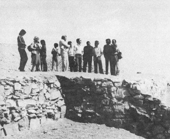
A group of participants visiting a pre-Columbian archeological site close to Arica.
Fernando Peralta
Civil Engineer
Alamos & Peralta Consultant Engineers Ltd.
1. GENERAL DESCRIPTION
The aim of this paper is to provide a summarized description of the availability of underground water at the Tamarugal Pampa.
1.1 Underground Water at the Tamarugal Pampa
Although the existence of underground water resources at the Tamarugal Pampa is generally taken for granted, it is necessary to make some comments regarding the conditions for its presence in the area, in order to shed some light on its present and future exploitation potential.
1.1.1 Location
The Tamarugal Pampa, from a geologic and geomorphologic standpoint, is a great North-Southwardly depression, encased between the Andes Mountains in the East and the Coastal Range in the West. It is filled by detritic lime, sand, clay and gravel material of the fluvial wash-off from Andean watersheds during the tertiary and quaternary periods. Volcanic and evaporitic events overlaid this filling process, accounting for the occurrence of liparite and volcanic ash pockets and gypsum, calcium carbonate and other evaporitic layers at given spots.
The northern boundary is the Tiliviche Creek and the southern one the Loa River.
The water is enclosed in pockets left by the granular material, such as sand and gravel. It is also found in clayish material; however, due to the electric attraction between this material and water, it is difficult to tap it. Therefore, for practical matters, this type of water will not be considered in this work.
1.1.2 Origin of the Underground Water
Two different origins are found, whose only difference is their time of occurrence. The first is water flowing in at the time of refilling, together with the fluvial carriage. This water is referred to as fosile, on account of its ancient date of inflow into the basin.
The second one is the modern —and, perhaps, present— recharge mechanism. It occurs from seepage and filtration from rivers and creeks located to the east, which, either permanently or sporadically, wash into this basin. The deep connection with waters from the Andean High Plateau, flowing beneath liparite layers, is not discarded.
1.1.3 Underground Water Flow
Once the water has filled the available spaces and starts to saturate the soils, it begins to seep from the higher elevations to lower locations, its speed depending on the degree of imperviousness of the materials it has to traverse.
As the Tamarugal Pampa is endorreic, the water forms small lagoons near the Coastal Range, or evaporates directly. In the latter case, after the water evaporates, a saline crust remains which, in time, seals the sector and bars any further evaporation, thus establishing a point of balance. Minor discharges occur at the northern and southern ends of the Tamarugal Pampa, towards the Tiliviche Creek and the Loa River, respectively. The existing natural or man-established vegetation, in turn, consumes part of the waters from the aquifer. Finally, there is a forced outlet, in the form of wells and pumps.
1.1.4 Salinity of the Underground Water
One of the questions naturally arising in a study of desert waters is salinity. This water, as it permeates the ground, is subject to a progressive salinization process, as it dissolves the salts it finds in its course.
The natural salinity of some waters, even before they infiltrate, derived from materials accumulated at the watershed by artificial runoff, must be added to this. It is important to mention that the waters in or adjacent to the evaporitic formations of the filling process will, naturally, have a greater content of salt particles.
In the particular case of the Tamarugal Pampa, the waters are, in general, of good quality, taking for a standard those waters with less than 1.5 g/l of dissolved solids. From the point of view of geographic location, the waters increase their salinity from East to West, and their dissolved solid content as they reach the western edge is 5 to 30 g/l.
As regards quality variation with depth, it is linked with the occurrence of saline layers and, to date, no acceptable correlation has been established for this phenomenon.
1.2 Quantifying the Resource
This is one of the most difficult tasks to perform accurately. An estimate is derived through a process of consecutive approximations, based on general research and observations of the aquifer during its exploitation.
Two aspects must be distinguished here:
A practical criterion to design an adequate use of the aquifer may be derived from the above factors.
Five underground reservoirs are distinguished at the Tamarugal Pampa, the estimation of whose size deserves individual treatment:
Only three of the above have been studied in this report, corresponding to those with tamarugo forest cover.
1.2.1 Zapiga Salt Flat
Taking an area of 150 km2 (30 km × 5 km) for the aquifer, with an average saturated thickness of 80 m and a 5% storage coefficient, the obtained volume amounts to 600 million m3. All figures are preliminary, and, in general, conservative, but make it possible to visualize the order of magnitude of the resource.
As regards periodical water intake, the studies carried out show a recharge at the eastern sector, between the Retamilla Creek and the area of La Aguada. This is evident both at the isopiezo curve charts and in the chemical quality charts, and from the observations of variation in water table level. A general rise was detected in the latter in 1972. The span of time during which water table levels were recorded —from 1976 to 1983— is very short for a desert zone, making it difficult to derive general conclusions on the subject.
1.2.2 Pintados Salt Flat
Taking an area of 800 km2, an average depth of 100 m and a 5% storage coefficient, a first approximation of 4 billion cubic meters of water is obtained for the stored volume.
The studies carried out show water inputs both from the southeast and the northeast. The same conclusion is derived from the chemical quality analysis. As regards the historical analysis of level variations, some increases are also revealed which take place in November and December, probably due to a recharge from the east.
However, with the present state of knowledge on the aquifer and the available data, it is not possible to provide a valid figure for the annual or hiperannual recharge rates. Nevertheless, an estimate has been made of 3–6 million m3 per year.
1.2.3 Bellavista Salt Flat
Basing on the same storage assumptions as above, for an area of 100 km2 and an average thickness of 80 m for the aquifer, a first approximation of the stored volume of 400 million m3 is obtained.
As regards the possible recharge, studies made previously indicate an inflow from the eastern sections, which can be placed at some 6 million m3 per year.
1.2.4 A System to Assess Stored and Incoming Volumes
A longer hydrological study together with a strict observation program, as proposed below, added to the help provided by simulation models, would make it possible to assess much more accurately the size of the resource in no longer than five years. In this regard any direct measurements made on the aquifer, both of its level and chemical quality variations, and extracted or evapotranspired volumes, will prove very valuable.
1.3 A Diagnosis of the Present and Future Situation of the Tamarugal Pampa Ground-waters
1.3.1 Water Use
As the aquifers are located in a desert area, where the importance of water is very high, it is not surprising to find conflicts of interest arising periodically in regard with the final use of this resource. The continuing development of the area has increasedly evidenced the competition for water use.
The knowledge on the existing groundwater resource is not thorough, thus prompting the users to look for water at the safest, easiest and, consequently, most economic places. Therefore, competition is not only for the use of the water resource, but also for the tapping spots.
Demand will increase with the sustained economic development of the region, making it mandatory to count on the greatest amount of accurate information on the conditions of the resource to make it possible for decisionmakers and users to dialogue on an objective basis.
1.3.2 Historical Level Decrease Observations
A major item in present and future exploitation of the resource is the analysis of what has happened with its levels in the last 15 years, taking into consideration the extractions made at the aquiters.
This research study devoted much effort to ordering, sorting, analyzing and synthesizing the available data on level variations.
Monthly variations were studied between 1968 and 1973, the only period of time for which data is available, on a total of 78 wells distributed among the Zapiga, Pintados and Bellavista Salt Flats (16, 43 and 19 wells, respectively). A significant number of these were located around or at the reforested areas. To establish a comparison, general measurements were made at 66 wells in 1980, as data recording activities had been suspended since 1973. The values found were compared against those made by CORFO in 1966, at 110 wells.
Although some pecularities are observed at each salt flat regarding the level fluctuations analyzed, a general synthesis can be made for all of them, as follows:
1.3.3 Tamarugo and Groundwater
Special stress has been laid on the analysis of the level variations at areas reforested with tamarugo. The conclusions arrived at are, again, similar among the salt flats: Zapiga, with 5,000 ha reforested, Pintados, with 18,800 ha, and Bellavista, with 2,400 ha. Conclusions may be summarized as follows:
It is not possibe to predict the future groundwater situation in relation to tamarugo, without resorting to a modelling process of the aquifer. Such approach would make it possible to test various water use options and consumption hypotheses which, set against the real reaction of the aquifer, would provide a much closer assessment of the future behaviour of the aquifer for different horizons.
1.3.4 Intense Exploitations
At each of these salt flats, but mainly at Pintados, water extractions are made through one or more drillings. When the extracted volumes are considerable, these outlets cause an inverted cone of level drop, whose tip at the well itself may reach several meters down. This is normal for groundwater exploitation. The dimensions can be extrapolated both in time and space only when there are enough comparison points in the vicinity.
The future outlook of these exploitations, if they continue to be intense, is toward lower water levels, greater lifting heights and the creation of a local vacuum at the aquifer which might reach considerable dimensions. To prevent this, with the concurrent higher cost of extracting the water, some solutions may be suggested, as larger spacing of the wells, taking into consideration the characteristics of the aquifer and its reaction to outside stimulae.
1.4 Possibilities of Managing the Tamarugal Pampa Aquifer as an Underground Reservoir
The Tamarugal Pampa is a major source of water for Region I, thus being it mandatory to subject it to careful management. Future development of the area and adequate prevention of future problems which might arise in connection with the water resource must be taken into consideration, to keep negative impacts at the minimum.
Current world trends regarding groundwater resource utilization are towards their management as an underground reservoir, based on hydrogeologic knowledge of the aquifers, an adequate observation of its behaviour, a simulation process of its characteristics and responses, and a progressive adjustment of its management with the changing requirements of the users and from the experience derived from the management itself.
Following, the major lines of action proposed to this end are described.
1.4.1 Observation and Control Network
This is the best way to know the characteristics and potential of the aquifer in regard to the various demands made on it. These controls pertain to the variation of saturation levels, water volumes extracted and chemical quality of the waters.
Level Observation Network
Made up by carefully selected observation wells, placed at strategical locations so as to represent the behaviour of the aquifer. Saturation levels are measured monthly or bimonthly. A preliminary proposal of 120 observation wells at the three salt flats has been made in the present study, 40 still to be built. Average depth is 20 m, giving an overall 800 m to drill in order to complete the network.
As the area to be covered by the observation wells is 1,050 km2, density amounts to I well every 8 km2, rated as adequate for a 1:50,000 scale study of a relatively homogeneous aquifer.
Maintenance of the wells is an important item in this network, together with periodical interpretation of the results and correlation of the measurements to detect errors, or make adjustments to the network in case of insufficiency or inadequacy of a given well.
Extracted volume records
All extractions from the aquifer are to be recorded, including their monthly volumes. These extractions constitute one of the more important outlets, and can be quantified. This volumes are to be compared with variationsin level, so as to establish a correlation by zone, thus considerably enlarging knowledge on the aquifer.
Chemical Quality Records
The dissolved solid content constitutes one of the limiting factors in the use of the Tamarugal Pampa groundwaters. It also helps to establish the provenance of the water. For both of these reasons, it is necessary to make periodical recordings of the chemical quality variation of the water. Measurements must be made twice yearly. Two trace elements are selected for this purpose, chloride ion and electrical conductivity of the samples at duly selected points. In this particular case, these spots will coincide with the observation wells.
1.4.2 Historical Analysis and Simulation of Aquifer Future Behaviour Under Various Hypotheses
Hydrogeologic knowledge makes it possible to design a simulation model by means of a mathematic scheme. Observation networks permit to enter the initial data for the selected simulation period, having a physical element against which to adjust the model to the realities of the aquifer.
Once the model has been refined, it is possible to state and try a series of exploration hypothesis providing a foreknowledge of the aquifer response to various situations. This constitutes an excellent tool for perfecting the management of the aquifer.
1.4.3 Discussion of Policies to be Adopted
Using the simulation model as a computing tool, it is possible to discuss on an objective basis which use is the groundwater reservoir going to be put to. It helps to decide how, where and when to extract water. Additionally, it warns of probable depletion of certain sectors of the aquifer in advance and, in certain cases, it can predict water salinization. The purpose is to provide managers with a sound set of data on which to base their decisions regarding the resource.
1.4.4 Programmed Exploitation and Model Adjustments According to the Real Response of the Aquifer
Once the users and managers reach a decision on resource utilization, programmed exploitation of the aquifer is undertaken. The same simulation model mentioned above is used. As the knowledge on the aquifer increases with the exploitation, a new set of data will come to light, eventually prompting some changes in the original exploitation model. Consequently, the program adopted must be flexible enough to accomodate this adjustments.
2. GROUNDWATER RESERVOIR BEHAVIOUR ANALYSIS BASING ON LEVEL VARIATION RECORDS FROM 1966 TO 1983
2.1 General
The fluctuation of the saturation levels of an underground reservoir stems from the combined effects of the aquifer water inputs and outputs.
Their periodical assessment makes it possible to know the reaction of the aquifer to the various water extraction situations and to the natural and man-made recharges. This reaction sheds important light on the physical characteristics of the aquifer, its nature and exploitation possibilities.
The recommended periodicity for the measurements is one month, adequate for the reaction inertia of the aquifer.
In the case of the Tamarugal Pampa, being this a desert area, a sufficiently long recording period is necessary to integrate the effect of sporadic mountain runoff, occurring in years with significant rainfall at the High Plateau.
This is a low-cost system to study groundwaters, as it does not require large outlays for drilling and trial pumping. It also complements previous research in the area.
2.2 Analysis of Level Variations Between 1967 and 1982
A comparison of the farthest and nearest points in time for which records are available is intended. These points correspond to 1967 and 1982 and, whenever possible, the same months have been compared for each year.
This 15-year span is significant for a desert area like this, and illustrates the influences which the different recharge and discharge processes have exerted on the aquifer. Of particular interest is the fact that all three underground reservoirs were subjected to reforestation with tamarugo, starting in 1967 and ending between 1971 and 1974.
The growing period for tamarugo is estimated at 12 years, thus being the trees presently near maturity.
Only one of the three salt flats studied has a mixed tamarugo-algarrobo forest —Pintados, at the Junoy forest—, with some 5,000 ha between both species.
There are presently around 22,000 ha reforested, without considering stocking rates, which vary among the salt flats and within themselves. The approximate distribution is 6,200 ha in Zapiga, 20,000 ha in Pintados —comprising both natural and man-made forests—, and 2,350 ha in Bellavista.
2.2.1 Zapiga Salt Flat
Eleven static level values have been compared between July, 1967, and June, 1982. The findings are presented in the table below.
Ten values are found to be apt for comparison, if A-1 is disregarded on account of the influence exerted by its own pumping. Increases are observed in five of them, and decreases in the remaining five. The decreases correspond to reforested areas and reach up to 0.82 m, with a possible mean of 0.50 m for the 15-year period. Increases are located at the eastern portions and at the southern end. Both positions coincide with recharge areas found in previous studies.
WATER LEVEL VARIATION AT THE ZAPIGA SALT FLAT BETWEEN 1967 AND 1982
| Coordinates | Static Level July 1967 (m) | Static Level July 1982 (m) | Variation (m) | ||
|---|---|---|---|---|---|
| 19.40–69.40 C-3 | 14.60 | 14.51 | + | 0.09 | |
| 19.40–69.50 A-1 | 33.50* | 17.35 | (+ | 16.15) | |
| 19.40–69.50 B-2 | 14.20 | 14.19 | + | 0.01 | |
| 19.40–60.50 B-3 | 7.60 | 8.18 | - | 0.58 | |
| 19.40–69.50 B-4 | 12.20 | 12.14 | + | 0.06 | |
| 19.40–69.50 B-5 | 8.00 | 8.53 | - | 0.53 | |
| 19.40–69.50 B-6 | 9.10 | dry to | 8.10 | ? | |
| 19.40–69.50 D-1 | 4.90 | dry to | 8.20 | ? | |
| 19.40–69.50 D-2 | 8.70 | 9.52 | - | 0.82 | |
| 19.50–69.40 A-2 | 21.00 | 20.82 | - | 0.18 | |
| 19.50–69.40 A-3 | 25.20 | 25.06 | + | 0.14 | |
It is worth mentioning that the 0.50 level decrease for the 15-year period may be due to water uptake by tamarugo, acting as an extraction. Apparently, a new point of balance has been reached, whereby no further decreases should be observed. The fact that increases have been recorded at the eastern and southern sections confirm this conclusion. The aquifer, therefore, is “alive”, with a new exploitation of groundwater by tamarugo which modified the former water levels until a new balance was reached.
The following table, to illustrate the phenomenon which points to a slow up of the decrease rates, includes the compared values for a total of 8 wells for May 1980 and January 1983.
COMPARATIVE LEVELS BETWEEN MAY 1980 AND JANUARY 1983 ZAPIGA SALT FLAT
| Coordinates | Static Level May 1980 (m) | Static Level January 1983 (m) | Variation (m) |
|---|---|---|---|
| 19.40–69.40 C-3 | 14.75 | 14.51 | - 0.24 |
| 19.40–69.40 B-2 | 14.17 | 14.19 | - 0.02 |
| 19.40–69.40 B-3 | 7.82 | 8.18 | - 0.36 |
| 19.40–69.40 B-4 | 12.09 | 12.14 | - 0.05 |
| 19.40–69.40 B-5 | 8.30 | 8.53 | - 0.23 |
| 19.40–69.40 B-6 | 9.10 | 9.52 | - 0.42 |
2.2.2 Pintados Salt Flat
Twenty-four measurements have been considered for comparison between January 1966 and January 1983, i.e., a 17-year span. Findings and figures are presented in the table below.
As can be seen, all points show a drop in level, varying from 0.23 to 4.94 m. This means that the new extraction represented by the 14,800 ha reforested has provoked a discharge from the aquifer. This drop averages about 1 m, corresponding as well to the new balance reached by the underground reservoir. If the observations made in 1982 —which indicated no general descending trend— are added to this, the above conclusion is confirmed.
In other words, it may be stated that if reforestation were continued at the salt flat, doubling the present forested area, within 15 years a new 1-m average drop would be observed in the saturation levels of the aquifer.
To illustrate the above, a Table with data for 14 wells, comparing the levels for May 1980 and January 1983, is shown below.
COMPARISON OF JANUARY 1966 AND JANUARY 1983 GROUNDWATER LEVELS PINTADOS SALT FLAT
| Coordinates | Static Level January 1966 (m) | Static Level January 1983 (m) | Variation (m) | |
|---|---|---|---|---|
| 20.10–69.30 C-17 | 23.17 | 24.66 | -1.49 | |
| 20.10–69.30 C-19 | 16.12 | 17.26 | -1.14 | |
| 20.10–69.40 C-2 | 20.39 | 21.06 | -0.67 | |
| 20.10–69.40 D-13 | 19.81 | 20.41 | -0.61 | |
| 20.10–69.40 D-14 | 17.34 | 18.22 | -0.88 | |
| 20.10–69.40 D-15 | 15.80 | 16.70 | -0.90 | |
| 20.10–69.40 D-16 | 16.40 | dry | (17.15) | — |
| 20.10–69.40 D-17 | 14.43 | dry | (15.18) | — |
| 20.10–69.40 D-18 | 11.40 | dry | (11.32) | — |
| 20.20–69.30 A-9 | 1.66 | 4.75 | -3.07 | |
| 20.20–69.30 A-11 | 5.37 | 9.25 | -3.88 | |
| 20.20–69.30 C-2 | 6.81 | 6.81 | 0 | |
| 20.20–69.40 C-2 | 6.74 | 8.00 | -1.26 | |
| 20.20–69.40 D-9 | 6.96 | 11.90 | -4.96 | |
| 20.20–69.40 D-13 | 10.20 | 12.38 | -2.18 | |
| 20.20–69.40 D-15 | 13.30 | 13.53 | -0.23 | |
| 20.20–69.40 D-16 | 12.09 | 12.94 | -0.85 | |
| 20.20–69.40 D-19 | 4.13 | 5.69 | 1.56 | |
| 20.30–69.30 A-9 | 1.68 | 4.75 | -3.07 | |
| 20.30–69.30 B-3 | 7.30 | 8.01 | -0.71 | |
| 20.30–69.30 B-5 | 10.67 | 11.20 | -0.53 | |
| 20.30–69.30 B-6 | 14.40 | 14.84 | -0.44 | |
| 20.20–69.30 C-1 | 2.84 | 3.97 | -1.13 | |
| 20.30–69.30 C-3 | 6.30 | 7.50 | -1.20 | |
| 20.30–69.30 C-7 | 3.06 | 3.95 | -0.89 | |
| 20.30–69.30 D-1 | 15.85 | 16.24 | -0.39 | |
| 20.30–69.40 B-2 | 3.96 | 5.03 | -1.07 | |
| 20.30–69.40 B-3 | 1.54 | 2.56 | -1.02 | |
COMPARISON OF MAY 1980 AND JANUARY 1983 GROUNDWATER LEVELS PINTADOS SALT FLAT
| Coordinates | Static Level May 1980 (m) | Static Level January 1983 (m) | Variation (m) | |
|---|---|---|---|---|
| 20.10–69.30 C-17 | 24.74 | 24.66 | + | 0.08 |
| 20.10–69.30 C-19 | 17.69 | 17.26 | + | 0.43 |
| 20.10–69.40 C-2 | 21.90 | 21.06 | + | 0.84 |
| 20.10–69.40 D-13 | 20.35 | 20.42 | - | 0.07 |
| 20.10–69.4- D-14 | 18.55 | 18.22 | + | 0.33 |
| 20.10–69.4- D-15 | 17.38 | 16.70 | + | 0.68 |
| 20.10–69.40 D-15 | 17.38 | 16.70 | + | 0.68 |
| 20.20–69.40 C-2 | 7.70 | 8.00 | - | 0.30 |
| 20.30–69.30 B-3 | 8.05 | 8.01 | - | 0.04 |
| 20.30–69.30 B-5 | 11.35 | 11.20 | + | 0.15 |
| 20.20–69.30 B-6 | 15.15 | 14.84 | + | 0.31 |
| 20.30–69.30 C-7 | 3.65 | 3.95 | - | 0.30 |
| 20.30–69.30 D-1 | 17.00 | 16.24 | + | 0.76 |
| 20.30–69.40 B-2 | 3.57 | 5.03 | - | 1.46 |
| 20.20–69.40 B-3 | 2.20 | 2.56 | - | 0.36 |
Of the 14 points, 8 show rises between 0.04 and 0.84 m. The remaining 6 show drops ranging from 0.15 to 1.46 m.
From a geographic standpoint, rises occur at the eastern and northern sections of the salt flat, coinciding with the recharge areas. Drops, in turn, are observed at the western edge of the flat, as it meets the Coastal Range. This proves the fact that the discharge caused by the new forests has reduced direct evaporation from the reservoir. This is considered a beneficial effect, for groundwater now serves to feed tamarugo instead of being lost in the atmosphere.
The most significant drops —3 to 5 m— occur in the reforested area, although, sporadically, the least significant ones are also located there. This evidences a stratification of the refilling layers with materials of different permeability, causing drops of different size at adjacent areas.
2.2.3 Bellavista Salt Flat
Water levels from March 1966 and January 1983 have been used to establish a comparison, covering a period of 17 years, which, as in the former case, is apt for the purposes of this study. There are 17 double-entry points, included in the table below.
As can be seen, 13 wells show a drop in level, ranging from 0.10 to 1.96 m, the majority between 0.20 and 0.30 m. There are, however, four points with increments, ranging from 0.10 to 0.53 m. The overall drop for the aquifer can be set at 0.25 m.
As in the case of Zapiga and Pintados, the decrease is attributed to the reforestation process. The 0.25-m average drop coincides with that found for the other salt flats, if the difference in area planted is taken into account.
From the monthly water level records for 1982, it can be drawn that the decrease took place in earlier years, the aquifer having presently reached a new point of balance between inlets and outlets.
COMPARISON OF MARCH 1966 AND JANUARY 1983 STATIC LEVELS
| Coordinates | Static Level March 1966 (m) | Static Level January 1983 (m) | Variation (m) | |
|---|---|---|---|---|
| 20.40–69.30 A-1 | 10.40 | 10.68 | - | 0.28 |
| 20.40–69.30 A-2 | 7.60 | 7.74 | - | 0.14 |
| 20.40–69.30 A-4 | 11.00 | 11.16 | - | 0.16 |
| 20.40–69.30 A-6 | 10.70 | 10.86 | - | 0.16 |
| 20.40–69.30 A-7 | 16.00 | 16.16 | - | 0.16 |
| 20.40–69.30 B-1 | 22.70 | 22.88 | - | 0.18 |
| 20.40–69.30 C-1 | 5.70 | 7.66 | - | 1.96 |
| 20.40–69.30 C-2 | 2.10 | 2.42 | - | 0.32 |
| 20.40–69.30 C-4 | 2.40 | 2.67 | - | 0.27 |
| 20.40–69.30 C-5 | 1.30 | 1.68 | - | 0.38 |
| 20.40–69.30 D-3 | 18.80 | 18.64 | + | 0.16 |
| 20.40–69.30 D-5 | 19.40 | 19.48 | - | 0.08 |
| 20.40–69.40 B-1 | 6.10 | 5.57 | + | 0.53 |
| 20.40–69.40 D-2 | 1.10 | 0.84 | + | 0.26 |
| 20.40–69.30 B-1 | 6.70 | 6.60 | + | 0.10 |
| 20.50–69.30 B-2 | 36.50 | 36.60 | - | 0.10 |
| 20.50–69.30 B-4 | 26.90 | 26.92 | - | 0.02 |
| 20.50–69.40 B-1 | 2.80 | 2.87 | - | 0.07 |
The outlet caused by the reforestation has reduced direct evaporation at the salt flat, thereby improving the utilization of the Pampa water resource.
The chart below shows the drops at each observation point of the aquifer for the 17-year span. The higher values for the afforested area are evident. It is interesting to note that the points which show rises are located in the vicinity of the old Victoria and Alianza nitrate mines, which became unoperative after the recording started.
The eastern sectors show minimum drops, confirming a recharging process for this aquifer.
As in the former cases, a comparison between the May 1980 and January 1983 levels has been made, for a total of 16 observation wells, included in the table below.
COMPARISON OF SATURATION LEVELS BETWEEN MAY 1980 AND JANUARY 1983 BELLAVISTA SALT FLAT
| Coordinates | Static Level May 1980 (m) | Static Level January 1983 (m) | Variation (m) | |
|---|---|---|---|---|
| 20.30–69.30 D-8 | 10.55 | 10.68 | - | 0.13 |
| 20.40–69.30 A-1 | 7.75 | 7.74 | + | 0.01 |
| 20.40–69.30 A-3 | 11.18 | 11.16 | + | 0.02 |
| 20.40–69.30 A-4 | 10.86 | 10.86 | 0.00 | |
| 20.40–69.30 A-6 | 16.24 | 16.16 | + | 0.08 |
| 20.40–69.30 A-7 | 22.70 | 22.88 | - | 0.18 |
| 20.40–69.30 B-1 | 7.22 | 7.66 | - | 0.33 |
| 20.40–69.30 C-1 | 2.34 | 2.42 | - | 0.08 |
| 20.40–69.30 C-2 | 2.62 | 2.67 | - | 0.05 |
| 20.40–69.30 C-4 | 1.56 | 1.68 | - | 0.12 |
| 20.40–69.30 C-5 | 18.97 | 18.64 | + | 0.33 |
| 20.40–69.30 D-3 | 19.87 | 19.48 | + | 0.39 |
| 20.40–69.30 D-5 | 5.57 | 5.57 | 0.00 | |
| 20.40–69.40 B-1 | 1.18 | 0.84 | + | 0.34 |
| 20.50–69.30 B-1 | 6.70 | 6.60 | + | 0.10 |
| 20.50–69.30 B-2 | 36.80 | 36.60 | + | 0.20 |
| 20.50–69.30 B-4 | 28.20 | 26.92 | + | 1.88 |
| 20.50–69.40 B-1 | 2.82 | 2.87 | + | 0.05 |
Nine wells show a rise in level and 7 show drops. The former ranges from 0.01 to 1.88 m, and the latter from 0.05 to 0.33 m. Again, rises are observed at the eastern sections of the flat, evidencing recharge. Descents are located at the reforested area. It is possible that at given areas the water level has not reached a new point of balance. Nevertheless, the fact that there are some points with higher saturation levels rules out a possible depletion of the aquifer as a whole.
3. THE WATER RESOURCES AT THE PICA-MATILLA-ESMERALDA AREA
3.1 General
Pica, an oasis just east of the Tamarugal Pampa, and the surrounding areas, Matilla and Esmeralda, have human settlements dedicated to tropical fruit and citrus production, with a significant economic yield. There is also an interesting road network, power generation and other infrastructure, and a long agricultural tradition. All this makes it particularly attractive to consider expanding the irrigated area.
Water, logically, constitutes the limiting factor for any development options in the area.
CORFO (Chilean Production Development Corporation) is interested in analyzing the possibiity of expanding the irrigated area. A series of agricultural, economic and hydrologic studies have been started to this end.
The diagnosis of the water resource situation—made by the private firm which released this report—was carried out from March 1984 to June 1984.
The first findings and results have been released in a report including a proposal for a systematic observation program, and setting forth several options for increasing water availability. Special stress has been laid on water level recording at observation and production wells and water flow rates from springs. This will serve as a sound basis to design an adequate use of the resource.
3.2 Water Resources
Water resources are tapped from the underground tables, or from springs.
Innumerable wells have been dug both for research and production purposes. A survey was made this year of a total of 98 wells recorded in previous research studies, 34 of which were identified —24 in Esmeralda, 4 in the vicinity of Matilla, and the rest in different locations in the area between the Juan de Morales and Chacarilla creeks. All are included in the table below.
OBSERVATION WELLS AT THE PICA-MATILLA-ESMERALDA AREA
| Sector No. | Coordinates | Constructor | Depth(m) | Ø" | S.L.(m) | Notes |
|---|---|---|---|---|---|---|
| Juan de Morales | 20.10–69.20 A-2 | CORFO 775 | — | 14 | — | Pumps |
| Cóncova | 20.20–69.10 C-5 | CORFO 679 | 100 | 14 | 40.23 | — |
| Cóncova | 20.20–69.10 C-6 | CORFO 698 | 1.60 | 16 | — | Sand-filled |
| Loreto | 20.20–69.10 C-9 | CORFO 735 | 3.68 | 15 | — | Sand-filled |
| Esmeralda 4 | 20.20–69.20 D-2 | D.de R. | 32.25 | 14 | dry | — |
| Esmeralda 7 | 20.20–69.20 D-3 | D.de R. | 100 | 12 | 41.84 | E.F.=1,250 |
| Esmeralda 12 | 20.20–69.20 D-6 | D.de R. | — | — | — | Pump |
| Qda. Seca 1 | 20.20–69.20 D-7 | CORFO 722 | — | — | — | — |
| Qda. Seca 2 | 20.20–69.20 D-8 | CORFO 781 | 16.2 | 14 | dry | — |
| Esmeralda 11 | 20.20–69.20 D-11 | D.de R. | 31.63 | 10 | 23.23 | E.F.=1,300 |
| Esmeralda 13 | 20.20–69.20 D-12 | D.de R. | buried under building | |||
| Esmeralda 14 | 20.20–69.20 D-13 | D.de R. | ? | 10 | — | Pumps |
| Esmeralda 15 | 20.20–69.20 D-14 | D.de R. | 74.23 | 10 | 38.24 | — |
| Esmeralda 16 | 20.20–69.20 D-15 | D.de R. | 77.66 | 10 | 49.40 | — |
| Esmeralda 18 | 20.20–69.20 D-16 | D.de R. | 98.52 | 10 | 31.67 | — |
| Esmeralda 19 | 20.20–69.20 D-17 | D.de R. | 100 | 36 | 30.05 | E.F.=1,100 |
| Esmeralda 20 | 20.20–69.20 D-18 | D.de R. | 64.54 | 10 | 32.15 | E.F.=1,350 |
| Esmeralda 25-A | 20.20–69.20 D-24 | D.de R. | 1.64 | 2.5 | — | Sand-filled |
| Esmeralda 27 | 20.20–69.20 D-26 | D.de R. | — | 36 | 37.68 | — |
| Esmeralda 28 | 20.20–69.20 D-27 | D.de R. | 50.63 | 10 | 46.35 | E.F.=600 |
| Esmeralda 31 | 20.20–69.20 D-30 | D.de R. | 64.12 | 10 | 37.55 | E.F.=700 |
| Esmeralda 33 | 20.20–69.20 D-32 | D.de R. | 74.23 | 10 | 38.24 | E.F.=700 |
| Esmeralda 34 | 20.20–69.20 D-33 | D.de R. | 57.45 | 10 | 42.76 | E.F.=700 |
| Esmeralda 35 | 20.20–69.20 D-34 | D.de R. | 54.40 | 10 | 43.40 | — |
| Esmeralda 36 | 20.20–69.20 D-35 | D.de R. | 1.07 | 2.5 | — | — |
| Esmeralda 39 | 20.20–69.20 D-38 | D.de R. | only landmark was found | |||
| Esmeralda 40 | 20.20–69.20 D-39 | D.de R. | 2.81 | 1.5 | — | Sand-filled |
| Esmeralda 41 | 20.20–69.20 D-40 | D.de R. | 1.36 | 1.5 | — | Sand-filled |
| Esmeralda 42 | 20.20–69.20 D-41 | D.de R. | 1.26 | 1.5 | — | Sand-filled |
| Esmeralda 17 | 20.20–69.20 D-42 | D.de R. | 44.33 | 10 | 44.31 | — |
| Chintaguay J | 20.30–69.10 A-5 | D.O.S. | — | 12 | SURG. | E.F.=420 |
| Matilla 2 | 20.30–69.1-A-6 | CORFO 676 | 100 | 14 | 20.62 | E.F.=2,350 |
| Matilla 3 | 20.30–69.10 A-7 | CORFO 697 | 1.82 | 1 | — | Sand-filled |
| Matilla 1 | 20.30–19.10 A-8 | CORFO 547 | — | 14 | SURG. | E.F.=2,200 |
| Matilla 5 | 20.30–69.20 B-2 | CORFO 764 | — | 12 | SURG. | E.F.=1,400 |
There are several wells at Pica which were formerly used for drinking water supply, but have since been discontinued on account of the establishment of a centralized drinking water facility. Several hand-dug wells, with flows of 0.5–3 l/s, supply water to small-sized croplands in the area of Pica and Matilla, and have been instrumental in expanding the irrigated area. To date, eleven such wells have been identified, with an exhaustive survey still to be undertaken.
Four springs and 9 dug-outs have been identified, representing the total amount of gravitational water in the area.
3.3 Size of the Resource
The outflow volumes of every observation or production well, dug-out and spring have been included, indicating their variation in time. All background data was collected, including some dating back to 1946; unfortunately, no systematic recording of these measurements has been made. For this reason, a monthly recording program has been started.
The Piga river has been added to these points, on account of its importance as an alternative water source for irrigation in Pica; this source was considered as early as the Spanish colonization period.
The table below includes the historical background data on water flow from springs and dug-outs.
SPRINGS AND DUG-OUTS AT PICA AND MATILLA OUTFLOW VARIATION
| Name of Source | Outflow in liters/second | |||
|---|---|---|---|---|
| 1946 | 1962 | Var.1962/1981 | ||
| Animas spring | 6.43 | 5.5 | 4.0 – | 10.6 |
| Cóncova spring | 8.25 | 9.5 | 4.8 – | 9.3 |
| Miraflores spring | 6.79 | 8.0 | 4.9 – | 15.0 |
| Resbaladero spring | 26.11 | 30.0 | 6.0 – | 66.0 |
| Buena Esperanza Dug-out | 0.36 | 0.9 | 0.4 – | 0.7 |
| Comiña | — | 0.8 | 0.2 – | 1.0 |
| Charcas | — | 1.0 | ||
| El Carmen | — | 2.2 | 1.3 – | 4.7 |
| El Sauque | — | 7.0 | ||
| Fdo.Espinosa | 0.5 | |||
| Jesús María | 1.55 | 2.0 | ||
| San Isidro | — | 4.0 | ||
| Santa Elena | — | 1.3 | 0.6 – | 5.8 |
| Santa Rosita | — | 17.0 | ||
4. CONCLUSIONS
- The level and conductivity records made in 1982, added to the previous data colected, have fulfilled the stated aims, becoming a valuable tool for the study and analysis of the hydrogeologic behaviour of the Zapiga, Bellavista and Pintados underground reservoirs.
- The current water extractions, located at various points of each aquifer, affect minor areas, except at Canchones (Pintados Flat).
- The Canchones extraction —supplying water to the city of Iquique— has provoked a cone some 1–2 km in diameter. An even larger inverted cone is expected as the extractions are intensified. First to be affected by this situation is the water utility company itself, from the higher lifting heights which will increase the unit price of the extracted water.
- The tamarugo plantations, although consuming groundwater, do not provoke marked seasonal drops nor a constant descending trend. This might indicate water extraction by tamarugo only during its vegetative growth period, when the water table level drops to a certain extent, to be recharged later.
- The chemical quality of the water recorded in 1982 is similar to that from 1967, with no indication of quality deterioration.
- A monthly oscilation has been detected at all three groundwater reservoirs (Zapiga, Bellavista and Pintados). This evidences the recharge and discharge mechanisms at each of them.
- The more marked variations correspond to the eastern sections of each of the reservoirs, indicating recharge areas with water infiltrated from high Andean watersheds.
- The areas with new data recording, started in 1982 within the afforested areas of both the Pintados and Bellavista salt flats, show variations of a more marked nature, arising form their location inside the forests themselves.
- No significant saturation level variations have been observed in the last six months, evidencing a general trend to stability, except for the points mentioned above.
- At a desert area as the Tamarugal Pampa, at least 5–10 years of level recording are necessary to draw significant conclusions. This first year constitutes the basis for data recording which should be continued in the future.
- The underground water reservoirs studied are rich in good quality water resources, the only source, in fact, to insure agricultural, mining, industrial and human settlement development in the region.
- The groundwater resources are presently under-exploited, and suitable for increased utilization.
- All further water extractions should be backed by a survey indicating the most suitable location, together with a periodic recording of the variations observed in water table levels.
- There are indications of a recharge taking place from the east. This would explain the steadiness of the levels through time and the minor variation provoked by tamarugo water consumption. Should no recharge exist, the evapotranspiration pattern of tamarugo would have caused a 5–30 m drop in the saturation levels at the different salt flats. As no evidence of this has been found, the conclusion follows that either tamarugo does not consume water, or there exists a recharge. The analysis of the monthly variations, however, does indicate water consumption by tamarugo, thereby confirming water recharge from the areas east of the aquifers.
- The analysis of the variations between 1980 and 1983 indicates that the decreasing trend of the saturation levels has bottomed. Half of the observation wells sunk reveals rises in level, mainly at the eastern portions of the aquifers.
- A drop in the water table level has been caused by the tamarugo plantations, ranging from 0.25 and 1.00 m at the Zapiga, Bellavista and Pintados Salt Flats. These drops stopped once the aquifer reached a new point of balance.
- The tamarugo-caused level drop has entailed a decrease in the direct evaporation from the aquifers, a beneficial effect of reforestation or afforestation. In other words, it may be said that the water which tamarugo consumes has been deducted from the evaporated volumes.
- It must be stressed that good quality water resources exist at the eastern portions of the Zapiga, Bellavista and Pintados Salt Flats.
- Future extractions from the aquifers should be located preferably at the eastern sections of the salt flats. Extractions should be well distributed so as not to provoke sharp drops at any given location. Sizable level drops increase water pumping costs.
- Continuation of a water level recording program is a must at all three salt flats studied, with the following periodicity:
every three months at the Zapiga, Bellavista and Pintados salt flats;
every month at the central areas of the Pintados and Bellavista flats.
- Conductivity should continue to be measured every six months at all three flats, and every month at the No. 1 spots at La Huayca-La Tirana-Canchones.
- The periodic control of the extracted volumes should follow the rhythm of the water level recordings at each sector.
- The possibility of increasing reforestation with tamarugo should be considered, as water resources are plenty, and not fully utilized.
- A better distribution of the extractions to supply water to Iquique is recommended, spreading tapping wells over a wider area. The Carmelo and Juan de Morales areas are suggested as suitable for the purpose.
- The use of hydrogeologic models is recommended to improve the utilization of the Tamarugal Pampa water resources. This would make it possible to count on foreknowledge of the aquifer response to different exploitation alternatives. The existing data are suitable for the design of hydrogeologic models for either or all of the aquifers studied. The data furnished by the exploitation of the reservoirs will make it possible to refine the model, so to obtain ever more accurate response predictions.
For the Matilla-Pica Sector
- The 150 ha presently under irrigation can be significantly incremented if four additional water sources are considered, namely:
The analysis of the alternatives suggested, parallel to the record keeping indicated above, is recommended to provide the management with a set of data sound enough to enable good decision-making.
- Far from being over-optimistic, a 100% increase in irrigation water availability can be predicted. Enough to back this assumption is to state that from the spring and well at Chintaguay alone, an additional 75 1/min can be obtained to irrigate 110 ha. This would imply that the settlements in the area could perfectly well be self-sufficient in water resources, basing on the findings of the studies so far undertaken.
Hernán Torres
Regional Director
Region I, National Forestry Corporation
Arica, Chile
INTRODUCTION
The world conservation strategy, promoted by the International Union for the Conservation of Nature (IUCN), identifies the “omission of integrating conservation and development”, particularly at the “rural areas of developing countries”, as one of the major obstacles for the maintenance of the ecological processes preserving genetic diversity and guaranteeing the sustained utilization of species and ecosystems on a worldwide basis (IUCN, 1980). In short, the strategy is oriented towards the control of the resources on the basis of “ecodevelopment”.
Wallaceana (1977) defined this concept as the search for the way to integrate economic and social objectives, at the same time as protecting —and occasionally enhancing— the environmental support systems. Its application is badly needed at the arid and semi-arid regions of the Third World, where the staggering number of environmental problems poses a threat not only to the resource base, but to the continued existence of many peoples as well.
That does not mean that these systems have little or no value; on the contrary, they have the capacity for lending support to certain kinds and levels of activity capable of improving living standards. However, since as a general rule the efforts to achieve development solely on the basis of experiences carried out elsewhere have failed, project goals must be biologically, sociologically and politically autoctonous to render the maximum amount of benefits to the community.
The establishment of protected areas in Chile has concurred well with basic ecodevelopment principles. Chile has nowadays 69 areas recognized by the IUCN: 27 national parks, 34 national reserves, 8 natural monuments and 6 biosphere reserves. Nevertheless, the arid and semiarid biogeographic provinces, accounting for over 50% of the national territories, are not thoroughly represented. In the whole Northern Chile there are two national parks, one national reserve and one natural monument, all of which are located in the Andean High Plateau.
Protected areas are still to be established at the lower altitude desert areas, particularly at the Tamarugal Pampa, which is the only tamarugo (Prosopis tamarugo) forest relict in Latin America.
It is understandable, therefore, that the National Forestry Corporation of Chile (CONAF) and several international organizations have granted priority to the establishment of the Tamarugal Pampa National Reserve at the Northern end of Chile.
DESCRIPTION OF THE STUDY AREA
The proposed national reserve is located in a desert environment, where the remnants of natural tamarugo forests provided the germoplasm to launch a massive reforestation programme by the Production Development Corporation of Chile (CORFO).
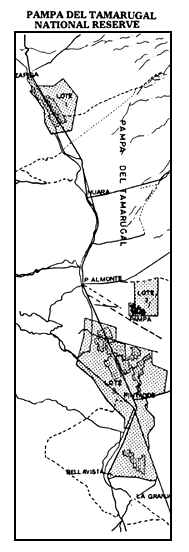
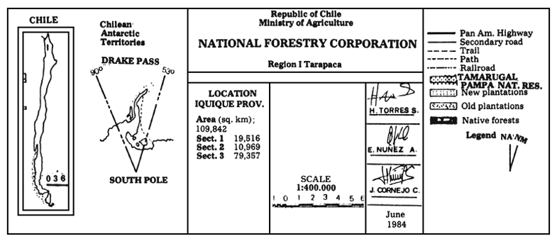
The proposed area, located in the districts of Huara and Pozo Almonte in the lquique province, Region I, Tarapacá, covers 109,842 ha, and is divided into three sectors. 3,241 ha of native forests, 22,943 ha of man-made forests and valuable geoglyphs —attesting human presence in the area dating hundreds or perhaps thousands of years back— will be protected and put under state management.
The climate characterizing the Tamarugal Pampa corresponds to normal desert, distinctive in its clearcut and severe traits.
This is not a hot desert area. In fact, inland pampas are over 1,000 m high, so that altitude intervenes as a temperature mitigating factor. Mean anual temperatures are below 18° C. The most relevant features of this climate are the almost total lack of rainfall and the broad range of daily temperatures.
The Central Depression, harboring the Tamarugal Pampa, runs from North to South, bordering on the East and West with the Andes and Coastal Mountain Ranges, respectively.
As a result of being a flat area confined by the aforementioned mountain ranges, the cyclic floods from the eastern mountain sections have deposited a considerable amount of salts, giving rise to vast salt deposits where the tamarugo trees thrive.
A number of deep wells dug for agricultural or drinking water purposes prove the existence of relatively important underground water courses, almost permanently running from East to West and not surfacing, given the lack of necessary pressure.
THE TAMARUGO FOREST
The Tamarugal Pampa owes its name to the existence of a relatively dense plant cover of the tree Prosopis tamarugo Phil., known commonly as “tamarugo”.
This Prosopis species is endemic to Chile. Its natural range is the Tarapacá Region, occurring most densely in the vicinity of the Pintados Salt Flat, at the Huayca zone, and at La Tirana.
Pisano (1966) states that tamarugo grows naturally at the Tamarugal Pampa. It is not a well known species, the successional stages of its appearance and natural range still obscure.
Ages of up to 400 hundred years have been established for tamarugos in the La Tirana area (Muñoz 1965). Its taxonomic position places it in the order Leguminosae, family Mimosaceae, genus Prosopis and species tamarugo (Muñoz 1965).
The associated fauna is represented by the reptiles Phrynosaura reichei and Tropidurus tarapacensis (lizards), the mammals Dusicyon culpeaus, Dusicyon griseus (foxes), Galictis cuya (huron), Ctenomys robustus and Phylootis darwini (rodents).
Among fowls, stand out Zenaida asiatica (pigeon), Speotito cunicularia (pequén), Tyto alba (owl) and several other species of the order Passeriforme.
In association with the dominant native species, Prosopis tamarugo, other species may be found in lesser proportion, such as Prosopis chilensis (algarrobo), Prosopis strombulifera, Prosopis burkartii (fortuna) and others belonging to the same genus, occupying the low and medium strata.
Among the smaller shrubs, the following may be mentioned: Atriplex atacamensis (cachiyuyo), Caesalpinia aphylla (retamo), Tessaria absinthioides (brea), Euphorbia tarapacana and Tagetes grandulosa. At the grass layer, Cressa cretica and Distichlis spicata may be found; the latter is a species which, when growing on salt flats, develops as a compact mass with considerable vertical growth. Some other species of this same genus occur in this area (CORFO 1982).
BENEFITS EXPECTED FROM THE CONSERVATION OF THIS FOREST RESOURCE
Often people not familiar with desert areas express their scepticism regarding the need of planning for these regions. What are the reasons for managing a significant portion of the Tamarugal Pampa?
Growing human pressure. Perhaps the most powerful reason for planning efforts in this area is that presently very little is managed with a view to obtaining sustained yields, either in protected systems or in joint control systems.
Pressure will continue to grow on the forests, with the result that the opportunities for biological studies, recreation in a primeval enviroment and other benefits will become more remote.
Common gene reserve. One of the major reasons for conserving intact the representative ecosystems, disregarding how “productive” they may be considered by today's standards, is their potential value as a source for germoplasm, both to improve the already domesticated species and to find new uses for them. The extreme aridity, heat salinity and lack of available nutrients select genes and give rise to features enabling survival in such regions as this. When domestic species are crossed with wild strains, there is a possibility of obtaining hybrids donned with higher nutritional value and other convenient characteristics. Desert plants provide fodder for livestock and food for human beings, along with raw material for a host of industrial products.
Primary production. Primary production is reduced in this part of Chile. Still, there are forest masses which, adequately managed, could be turned to fuelwood production, wood for handicrafts and timber for minor industrial applications. The Production Development Corporation (CORFO) has systematically tested the fodder properties of tamarugo, a task which should be continued to achieve the highest possible sustained yield. If this area is put under adequate management, its capacity for supporting both domesticated and wild fauna will be enhanced.
Recreational opportunities. The topography of the area, the purity of its air, its interesting flora and fauna, its scenic beauty and proximity to Iquique and Arica, make the area attractive to many outdoor activities. Indeed, one of the basic reasons for undertaking this planning effort, is to give room to all these activities, together with controlling the increasing and haphazard use of the area, in itself contributing to air quality impoverishment, particularly from the disposal and abandonment of refuse, and pests which are prone to control, etc.
Opportunities for research. The growing national and international concern for this endemic species finds here an ideal location for basic and applied research activities in the field of biological, social and archeological sciences.
Opportunities for environmental education. Doubtlessly, schools and universities will use the area to conduct the practical aspect of their theoretical education. Field trips could also be organized for Iquique and Arica dwellers, and for national and international tourists.
OVERALL VIEW OF THE PLANNING PROCESS
The main purpose of the project is to plan the management of the proposed Pampa del Tamarugal National Reserve, so as to protect certain natural and cultural resources and, at the same time, insure the sustained yield of a number of products.
Bearing the primary aim in mind, an interdisciplinary planning team will be formed, stating the specific management objectives, among which fodder and wood production will be considered, along with wildlife habitat, opportunities for research and outdoor recreational activities, and an education based, partly, on the socio-economic needs of rural and local populations.
The planning process for the Pampa del Tamarugal National Reserve will acommodate to the framework described by Miller (1980) and Linn (1976). This general framework has been divided into three stages:
Diagnosis: This stage includes selecting the initial site, reconnaissance of the area, resource data collection and designing of a conceptual planning model; establishment of official contacts with the local authorities, with the communal farmers and private landowners near the area to be protected; definition of the boundaries and establishment of management practices in certain areas, such as erection of fences, pest control, livestock grazing, etc.
Formulation of a strategy and proposal of management alternatives: As planning for the multiple use management of a given area affects not only the resources of the area, but also those of the neighboring areas, the occurrence of conflicting interests is foreseen. It is evident that the rational solution of these conflicts is mandatory prior to adopting any decisions regarding a given exploitation alternative. Therefore, the analysis of the data will be started with models which make it possible to compare those potential yields commercial in character with the non profit ones. In short, utilization scenarios will be formulated. Once all these alternatives —and the administrative projections thereof— are well understood, a first zoning plan can be adopted.
Scheduling requirements to start up the management plan: In this stage, the Area Management and Development Plan is formulated. The Management Plan will include strategies for the conservation of the resource, the requirements for long term scientific studies, and the scientific observation both of the way the ecosystems function and of the consequences of the presence of people. It will include as well management programs considering maintenance, personnel and licence policies, as well as public use activities contemplating interpretation services, environmental education and outdoor recreation.
ACHIEVEMENTS TO DATE
A complete collection of basic studies made by CORFO is available. The analysis of the resources has been completed and an adequate proposal for the boundaries of the Reserve has been filed. Official contacts have been established with the local authorities and residents, which has made it possible to offer the lease of 6,100 ha for grazing, benefiting 23 rural households raising a stock of 3,200 sheep and 2,900 goats.
The technical conditions demanded for the establishment of this grazing activity are the determination of the animal stocking rate per ha, animal health and reproductive management. This proves the value of tamarugo as a fodder tree.
An assessment of the damage exerted on tamarugo fruit and inflorescence by lepidopteron larvae has been made, and standards have been defined for the biologic control of these pests.
By means of aerial photointerpretation and digital interpretation of LANDSAT satellite images, mapping the distribution of the stands by age is under way. Likewise, the area damaged by insect attack is being measured.
A joint genetic resource conservation program is under way with the Food and Agriculture Organization of the United Nations (FAO), with the general purpose of collecting, evaluating and utilizing the genetic resources of forest species apt for contributing to the improvement of living standards in communities located in arid and semi-arid regions of the world. In a second stage, assessment trials of the selected arboreal species is considered.
CONCLUSION
This planning effort was started in November 1983, when the Production Development Corporation (CORFO) transferred the forest mass planted to the National Forestry Corporation (CONAF). The area of these forests amounts to 22,943 ha, successfully reforested, and it will be expanded to 109,842 ha, to make up the Pampa del Tamarugal National Reserve. Besides the transferred forest mass, 3,241 ha of natural forests, and an open area which includes salt flats, soils apt for reforestation, and valuable archeologic features (geoglyphs), of great national and international value will be conserved.
 |
This is an ambitious project of the National Forestry Corporation, Ministry of Agriculture. When this project is fulfilled, the scientists will profit from a major genetic bank for their research activities, tourists looking for recreation will enjoy camp life, hiking, etc., in a portion of the Chilean desert, managed in such a way as to insure good quality outdoor life, and the general public will have a chance to understand the complex ecologic system at hand. Most important, from the ecodevelopment standpoint, is that the local communities will benefit from employment opportunities in the area and from the long term management of its resources, aiming at perpetuating productivity in all its aspects.
Despite being the cause of the present management problems at the Tamarugal Pampa, man is capable of solving these problems in such a way as to insure ecologically healthy development. Chile will be the great loser if this region is not managed with more future vision, while, on the other hand, the benefits resulting from the efforts of integrating its unique resources are many and varied.
REFERENCES
CORFO 1983. Actividades Forestales y Ganaderas en la Pampa del Tamarugal 1963–1982, Tomo I.
EHRLICH M. 1978. Alternative Management Systems for Conservation Areas (De Facto) Human Development: A Study of Area Management and Strategy Implications in Peru. IUCN/WWF.
HABIT M. 1981. Prosopis tamarugo: Arbusto forrajero para zonas áridas. FAO, Rome.
INSTITUTO DE INVESTIGACIONES DE RECURSOS NATURALES 1976. Inventario de Recursos Naturales por Método de Percepción del Satélite LANDSAT. I Región.
LINN R.M. 1976. Introducción a la Planificación de Parques. Washington.
MILLER K. 1980. Planificación de Parques para el Ecodesarrollo en América Latina. FEPMA. Madrid.
MUÑOZ C. 1966. Una nueva especie de Prosopis para el Norte de Chile. Boletín Museo de Historia Natural. Chile.
WALLACEANA 1977. Ecodevelopment News.
![]()
![]()
![]()