


by
D. B. Dhital
Department of
Forestry Services
Thimpu, Bhutan
May 2000
Table of contents
1. Background
2. National Forest Policy
3. State of Forestry in Bhutan
3.1 The Forest Resources
3.2 Organization of Department of Forestry Services
4. Management Planning
4.1 Planning Level
4.2 Forest Resources Inventory
4.3. Forest Zoning based on functions
4.4 Collection of Socio Economic Data
4.5 GIS- Tool for management planning
5. Analysis of Data
5.1 Forest Inventory
5.2 Analysis and Grouping of Forest Functions
5.3 Constraints in Management Planning
6. Monitoring
Bhutan is a small country, located in the eastern Himalayan zone of Asia. It measures roughly 300 kilometers (E-W) by 150 kilometers (N-S). The total geographical land area is 4.024 million hectares. Bhutan is bordered to the north by China (Tibet) and to the east, west and south by India. (see map 1). The country is mountainous and the elevation ranges from about 200 metres in the south to over 7550 metres in the north. The major river systems flow from the high mountains in the north towards the lower area of the south. These rivers create the inner valleys where the population centers are concentrated. The road systems also follow these valleys within the country and also with its neighbours. (see map 2).
Bhutan is predominantly rural economy with about 80% of the population still living in the rural areas. Out of the total area of 4.024 million hectares, forests occupy 2.9 million hectares. (LUPP, 1995). Therefore, the important role of forests in protection of its environment and production of timber and fuelwood for the people cannot be overemphasized. The Royal Government policy is to retain at least 60 % of the geographical area under forest cover for all times to come. Judicious and sustainable supply of the forest produce to meet the timber and fuelwood need of the local people, Government Organizations, local forest based industries, without compromising the protective role, is the priority area of forest management in Bhutan. There are constraints that are generally encountered, for effective management of the forest because of lack of funds, uncertainty of regeneration in the conifer zones and shortage of trained human power.
Before the creation of the then Department of Forest (DOF) now Department of Forestry Services (DoFS) in mid 1950s, forest resources were controlled by Civil Authorities. People used to get their timber and firewood requirement from the district offices. Harvesting of timber on commercial line started after the first forest management plan was approved by the Royal Government. The demand, of the forest produce, then, was quite insignificant. However, with the advent of industrialization and value-addition, the demand on the forest produce increased manifolds.
In the temperate belt, the areas near the habitation have secondary blue pine crop. It may be because of over-use by local people, for their bonafide purposes, in the past. After the strict implementation of the Forest and Nature Conservation Act of Bhutan 1995, and more vigilance from the forestry staff, the blue pine has regenerated prolifically invading even the villagers' agricultural fields, resulting in the secondary crop of this species.
There are four guiding statements of the national forest policy of 1991. The purpose of the policy statement is to ensure that forest resources are used according to sustainable principles, contributing to social justice and equity. Further the policy will primarily ensure conservation of the environment, and only thereafter aim at derivation of economic benefits from the forest as a rationally managed resource. The policy statements are given below, in order of priority.
The main thrust of the National Forest policy is to bring the government reserved forest of the country under effective and scientifically prepared forest management plans. To achieve this, requirement of approved forest management plans, as a condition, for any commercial harvesting of forest produce has become imperative. Consistent with the above statement, the primary objectives of the forest management are:
To conserve the fragile environment of the country;
To ensure a sustainable supply of timber, fuelwood and animal grazing and non-timber forest products for the local consumption;
To allocate sustainable forest products in excess of local needs to promote value-added forest based industries.
A number of important criteria have been developed to guide the development of these forest management plans in order to achieve the above mentioned objectives:
Ø Managed forests should attempt to satisfy local requirements for timber, fuelwood, grazing, fodder, compost litter and other traditional uses on a first priority;
Ø Forest will be managed for long term sustainable yield, with allowable harvest calculations based on a detailed forest inventory and scientific growth and yields studies;
Ø Forest harvesting systems should ensure environmental protection by minimizing soil erosion and land degradation, protecting natural drainage systems and avoiding permanent changes in the composition of vegetative species;
Ø Forest management should be holistic and should consider not only the production of forest commodities but also watersheds protection, wildlife conservation, maintenance of biodiversity and social uses;
Ø Silvicultural systems should ensure regeneration of the principal species by natural means and only if natural regeneration is not obtainable should artificial regeneration techniques be adopted.
All the lands in Bhutan, which are not explicitly registered as private land, has been declared to be government reserved forests. The natural, ecological and climatic conditions of Bhutan favour the forests as dominant form of land use. Due to both cultural and physical remoteness, Bhutan has retained much of the natural vegetation, hence has a relatively intact natural forest estate. Together with a low population base, these factors have kept forest exploitation to a minimum, a condition greatly in Bhutans favours for moving towards sustainable use of natural resources.
The total land area of Bhutan is 4.024 million hectares (MPFD, 1991). The total forest area of the country is estimated at 2.90 million ha. (LUPP, 1995). From the information compiled by LUPP 1995, the forest land base, district wise, is given in Table 1.
Table 1. Distribution of forest area by districts
Districts |
Area in ha. |
Percent. |
Thimphu |
108398 |
4 |
Paro |
83787 |
3 |
Haa |
134447 |
5 |
Chukha |
156605 |
5 |
Samtse |
127910 |
4 |
Punakha |
87112 |
3 |
Gasa |
144872 |
5 |
Wangduephodrang |
298072 |
10 |
Tsirang |
48658 |
2 |
Dagana |
114108 |
4 |
Bumthang |
181135 |
6 |
Trongsa |
158249 |
5 |
Zhemgang |
184431 |
6 |
Sarpang |
190651 |
7 |
Lhuentse |
217350 |
7 |
Mongar |
172258 |
6 |
Trashigang |
180272 |
6 |
Trashiyangtse |
110095 |
4 |
Pema Gatshel |
27750 |
1 |
Samdrupjongkhar |
178362 |
6 |
Total |
2904522 |
100 |
The major forests types are broadleaved 34.3 % and the rest is conifer, 26.5 % (LUPP, 1995). Table 2 gives a detail picture of the forest types of the country.
Table 2. Area of different forest types of Bhutan
Forest Types |
Area (ha.) |
Percent. |
Fir Mixed Conifer Blue Pine Chir Pine Broadleaved + Conifer Broadleaved forest Conifer plantation Broadleaved plantation Scrub forest |
3453 4868 1286 1009 1358 13749 20 44 3258 |
8.6 12.1 3.2 2.5 3.4 34.3 0.1 0.1 8.1 |
Total Forest |
29,045 |
72.4 |
3.2 Organization of Department of Forestry Services
The Department of Forestry Services is headed by an officer at the rank of Dire ctor. At the district level there are territorial divisional forest officers, who are responsible for carrying out all the developmental activities related to forestry sub-sector. To assist the Director in the technical matters, there are three functional divisions at the headquarters, viz.; (i) Forest Resources Development Division (ii) Nature Conservation Division (iii) Forest Protection And Utilization Division (see organizational chart 1)
There is one autonomous Corporation called Forest Development Corporation, (FDC) which deals with all timber harvesting and marketing aspects. However, all harvesting of the timber, is guided by the forest management plans prepared by Forest Resources Development Division.
The territorial divisional forest officers are overall incharge of all the implementation aspect of forestry activities in the districts.
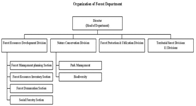
Chart 1. Organization chart of Forest Department
The Department of Forestry Services (DoFS) has established a strong policy on managing the forest resources for the protection of environment and sustainably meeting the need of the local people. Forest resources utilization for commercial purposes is secondary and export of timber and firewood, in primary form, is totally banned.
The Forest Management System is characterised by different levels of management and planning horizons. The planning level discussed under Table 3 is expected to resolve the economic, social and ecological problems of sustainable forest management and utilisation.
Table 3. Levels and major components of the forest management planning
Management Level |
Planning Horizon |
Major Components |
National Level |
10-20 years |
Forest Sector Master Plan Forest Policy Legislation (Forest Act & Rules) |
Forest Management Unit (FMU) Level |
10 years |
Forest Zoning (Forest Functions) Resource Assessment Yield Regulation |
Operation Plan Level (Usually at Compartments Level) |
Annual (Two years rolling plan) |
Silviculture and Harvesting Non-Wood Forest Products Harvesting operations |
At the National level, planning is handled at the forestry sub-sector level and deals with the relationship between forestry and various other public sectors such as agriculture, livestock, industry, tourism and mining. It involves policy decisions on land-use planning, forest functions, and raw material supply, industrial processing capacities and issues related to legislation and fiscal incentives.
4.2 Forest Resources Inventory
Forest resources inventory is a method of collecting necessary information about the size and shape of the area. Information in terms of qualities and quantities of timber stocks or other relevant resources obtained in this way serve for resource planning and monitoring.
Besides describing the quality and quantity of growing stock, other characteristics of land upon which the trees are growing are also described/collected. Information on forest inventory is the first and foremost tool for a good forest management. Management inventories are conducted to estimate stand density or volume and the information is then used to decide how the stand will be managed in the future. Similarly forest inventories determine the presence or absence of threatened or endangered species which may have a profound effect on future management. Forest inventories serve as the source of information for decision making. They have been, or will continue to be, a necessary activity for foresters. Continuous forest inventory enables us to monitor the changes in the growing stock or forest dynamics.
Forest resources inventories are repeatedly carried out at intervals of 10 years covering the entire production area of a forest management unit.
While conducting forest inventory it is very important that certain basic information, with certain level of precision, are collected. Any design could be used to achieve this. For example, in order to adequately estimate future productivity of the forest and to plan for appropriate silvicultural treatments the inventory should cover all size classes of trees and species, from the oldest mother trees right down to the regenerations. Individual trees are assessed for their stem and crown quality to obtain a better insight into their survival and growth. Additional information on topography and site characteristics (e.g., slope, soil type, fertility and level of disturbance etc.) are also collected which will assist in the planning of environmentally sound forestry operations.
It is important to point out, that field sampling is indispensable especially for reliable identification of species and assessment of the regeneration. However, satellite images and aerial photographs can also be used to supplement the results of field inventories. They are specifically helpful for the selection of harvesting, tending and reforestation areas.
While designing the inventory, the following points are considered
(i) the objectives of the inventory;
(ii) the accuracy desired;
(iii) the extent and nature of the area;
(iv) condition of the forests and;
(v) costs.
Based on the above-mentioned points, the forest inventory are designed with the following objectives:
(i) to provide a relatively accurate overview of the growing stock and regeneration potential of the natural forest in the area, according to major forest types;
(ii) To give an overview of the general site characteristics of the natural forest, in terms of soils, non-tree vegetation and use by local people;
(iii) to provide an indication of timber quality in the different forest types;
(iv) to furnish essential data on tree height to enable the construction of local volume tables for the main species;
Therefore in order to capture the above mentioned information, the design and field works are geared to collect the following information:
(i) species found in the area; (ii) stand types; (iii) volume per hectares; (iv) basal area per hectares; (v) periodic annual increment per hectare, (vi) site condition of the area.
Because of the difficult terrain, the inventories are designed aiming at sampling error of ± 10% at confidence level of 95%. The number of sample plots are calculated using the formula given below:
n = ( t2 * CV2 ) /SE%2.
Where,
n = number of sample plots required,
t = t distribution ( at df = a, p= 0.05)
CV% = Coefficient of variation (The average value of coefficient of variation is taken to be 85%).
SE % = Sampling error (SE % was taken to be 10%).
4.2.2 Location of Sample Plots
Usually the sample plots are located in a North-South direction.
4.2.3 Data Recording on Sample Plots
The data, on each sample plot, are recorded on format (see annexure 1). The details of each parameter are briefly given below:
1. Name of the inventory unit
2. Plot number
3. Any special observations
4. Altimeter reading
5. Land use type
6. Canopy height
7. Canopy closure
8. Accessibility
1. Aspect
2. Stand condition
3. Non-tree vegetation
4. Sign of commercial wood extraction
5. Sign of domestic wood extraction
6. Sign of grazing
7. Fire
8. Shifting cultivation etc. etc.
Soil
1. Stoniness cover
2. Depth litter + humus
3. Top soil colour
4. Top soil moisture
5. Top soil texture
Wildlife
Wildlife observation is done only in the major plots for.
1. Identification of the different species of animals; or
2. Recording the evidence of a particular species based on the signs.
The regeneration is recorded on the regeneration plots only. Recording is done for 1.30 metres height and up to 9cm. dbh. of the commercially valuable species.().
4.2.4 Selection of Trees for Measurement
After recording the general plot information as described in the above-mentioned paragraphs, and field verification that the plot is accessible and falling in the natural forest, the other data are collected from the measurement of live trees having a dbh of 10 cm. and more. The sample plot, used in our inventory is a combination of 3 overlapping circular sub-plots as shown in Figure 1.
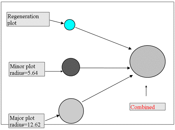
Figure 1. Size and shape of the sample plots
The specifications for the constituents concentric sub-plots (fig. 2) of the sampling unit are given in Table 4.
Table 4. Specifications for the constituents concentric sub-plots of the sampling unit
Sub-plot |
radius(m) |
area (m2 ) |
area (ha.) |
dbh of 'in' trees |
Regeneration |
3.57 |
40 |
0.004 |
0-9, taller than 1.30 m. |
Minor |
5.64 |
100 |
0.01 |
10-29 cm. |
Major |
12.62 |
500 |
0.05 |
30+ cm. |
Diameter at breast height (dbh) of all the sample trees are measured at 1.30 metres height from the ground level using the diameter tapes.
Total tree height measurement is done only in the special plots. Every 4th plot is identified as the special plot. The height of the trees are measured using the clinometers and entered in the tally sheets.
4.3 Forest Zoning based on functions
At the level of a forest management unit, planning is undertaken for all forestry activities as shown in figure 2. The forest management plan, among others, also contains the prescribed measures to mitigate the environmental impact of forestry activities, as required by Environmental Impact Assessment Rugulations (EIA). Thus, the management plans can be considered as functionally equivalent to an EIA report. The functions broadly identified and mapped are given in figure 2. The prescriptions are also drawn to suit the functions.
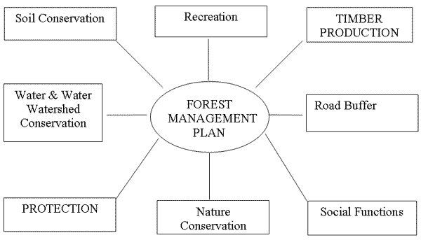
Figure 2. Main forest function groups
All three management levels and their different components are closely linked and interdependent.
At the operational plan level, silviculture, harvesting, non-wood forest products, compartment level forestry operations, resource accounting and control of activities are carried out.
As pointed out in the following table five1 main groups of functions are identified. Each one includes a number of sub-functions, which are differentiated among each other by their influence on forest management (degree of management prescriptions). For the sub-function the term protection is used if commercial use is prohibited, the term conservation - or a more specific phrase is used, if the function imposes management restrictions on the commercial use. In case a function group contains both protection and conservation functions, then for the function group the term conservation has been selected (i.e. Soil Conservation, Water and Watershed Conservation, Nature Conservation). The detail sub functions are given in table 5.
Table 5. Different forest function groups and sub-functions
Soil Conservation |
Water and Watershed Conservation |
Nature Conservation |
Social Function |
Road Buffer |
SP Soil Protection |
WRR Riparian Reserve Protection |
NWP Wildlife Protection |
SocRS Religious Sites Protection |
RB Road Buffer |
SC Soil Conservation |
WLS Local Water Supply Protection |
NWC Wildlife Conservation |
SocL Social (Local Use Only) |
|
WSMA Special Management Areas around Water Courses |
NB Special Ecological Niche Protection |
SocLC Social (Local cum Commercial Use) |
||
WSh Watershed Conservation |
The definition and objectives of each sub functions and their legal provision in the Forest and Nature Act of 1995 is discussed below:
The group Soil Conservation is one of the most important functions and it is defined in order to prevent land and snow slides, damages caused by falling stones or rocks, protection of arable land, etc. Also, the protection of the topsoil from erosion is an essential measure in order to maintain the fertility and production capacity of the soil in the long run, which is a pre-condition for sustainable forest management and agriculture.
Definition |
Soil Protection includes all areas, which are extremely sensitive to soil erosion, land, and snow slides. These areas include in particular very steep slopes, rocky and stony areas, and waterlogged and already eroded areas. Unstable slopes above or near important objects such as villages, settlements, individual houses, roads, agricultural land, etc. are defined for protection reasons as Soil Protection. |
The function "Soil Conservation" covers all areas, which are sensitive to soil erosion, for example, steep slopes, waterlogged areas and exposed sites. |
Objective |
(1) to prevent damages caused to the environment and infrastructure by land slides, snow slides, falling stones and other physical impacts; (2) to protect the soil from erosion and to sustain soil fertility. |
(1) to minimize or prevent negative impacts due to forest resource use in order to protect the soil from erosion and other degradation processes and to sustain soil fertility. |
Legal Restrictions |
According to § 14 a (iii) of the Forest and Nature Conservation Act (1995) "no permits shall be issued to fell and to take any timber where the slope is greater then 45 degrees (100%) unless authorized under an approved management plan or by the Head of the Department." |
None. |
Identification |
Soil erosion depends largely on geology, site conditions (soil type, water regime, etc.) and slope gradient. In general it can be said, the finer the soil texture, the steeper the slope and the higher the water content (saturation) the more sensitive the soil becomes towards erosion and landslides. Unfortunately, up to date soil map does not exist for Bhutan and soil mapping for entire FMU would definitely over stress the human resources of the Department of Forestry Services. The only parameters which can be comparatively easily assessed are the slope gradient, the land use type and already existing signs of erosion (gullies, rills, land slides, etc.). | |
|
The following areas shall be classified as Soil Protection: very steep areas (slope above 100%); unstable areas and sites prone to landslides and areas with indications of severe erosion. |
The following areas shall be classified as Soil Conservation: steep areas (slopes of 76-100%); areas with indication of slight to moderate erosion; exposed sites (ridges, etc.). | |
4.3.2 Water and Watershed Conservation
Water is one of the most valuable natural resources and clean potable water is an indispensable asset for the human population. The protection of water resources therefore gains highest priority in resources management. The function "Water and Watershed Conservation" focuses on the conservation of the cleanliness of the groundwater and surface water bodies and the maintenance of a continuous water supply. According to the objective of the function and the management prescriptions different sub-functions are defined.
|
Riparian Reserve Protection (WRR) |
Special Management Areas (WSMA) | |
|
Definition |
Riparian areas occur along the banks of rivers and streams, and around the perimeter of lakes and wetlands. They include the water body itself, areas subject to periodic inundation and flooding, areas with high water tables and immediate adjacent uplands. Streamside vegetation stabilizes stream banks, regulates stream temperatures through shading, and supplies a continual source of coarse woody debris to stabilize stream channels and diversify aquatic habitat. The majority of fish food organisms come from overhanging trees and shrubs, while the nutrients from organic materials that fall or wash into the stream are the basis of aquatic ecosystem productivity. Riparian areas often contain the highest plant and animal diversity, and some of the highest valued non-timber forest resources in the forest landscape. They provide critical habitats, home ranges and travel corridors for many mammal and bird species, and maintain ecologically important vertical and horizontal linkages throughout the forest landscape. | |
|
Objective |
(1) to minimize or prevent negative impacts due to forest resource use on stream channel stability, water quality, and aquatic ecosystem productivity and diversity; (2) to protect and sustain plant diversity associated with riparian areas; and (3) to allow sustainable and environmentally-sound forest uses consistent with objective (1) & (2) above. | |
|
Legal Restrictions |
According to § 14 a (ii) of the Forest and Nature Conservation Act (1995) "no permits shall be issued to fell and take timber within 100 feet (30 m) of the bank or edge of any river, stream, water course and or water source. | |
|
Identification |
Stream courses in mountainous landscapes vary considerably in gradient, cross section, flow, stability and ecological importance. To ensure adequate protection the characteristics of the water courses have to be taken into account. | |
|
The Riparian Reserve includes the stream bed and extends to the top of the entrenchment slope. Along alluvial and semi-alluvial rivers and streams the width of the Riparian Reserve is 30 m. |
The size of the Special Management Area extends to the specified distance from the top of the stream bed. Large non-alluvial rivers: 100 m Alluvial and semi-alluvial to edge of active rivers and steams:flood plain | |
|
Short Description of Management Prescriptions |
Strict Protection! Within buffer zones (riparian reserves) along streams, small rivers and perennials, it is not allowed to carry out any forestry operation except those required to improve the forest condition and to restore its original natural condition. Such rehabilitation activities are: reforestation of cleared sites, beating up, tending, weeding and, if necessary from the silvicultural viewpoint in order to increase stability, thinning. All those activities have to focus on the establishment of multi-structured, uneven-aged mixed forests and they have to be carried out manually only. The use of machines is strictly prohibited. Local use is limited to the collection of NWFP. Cattle grazing and leaf litter collection are not be allowed. The establishment of infrastructure like logging roads, establishment of log ponds, housing, sawmill and other utilization units, camp-sites, log landings etc. is strictly prohibited within these areas. (Note: Removal of trees shall be considered on epidemic out-break & silvicultural reasons.) |
Only management restrictions! Forest harvesting operations within the special management zones and 20 m from the top of the entrenchment slopes should minimize disturbance to understory vegetation and damage to residual trees. Silvicultural systems should focus on natural regeneration, with enrichment planting wherever necessary. Clear cutting is prohibited. Woody debris, occurring in the site, should be maintained and no weeding or burning or slash disposal should take place. The conversion of natural forests into plantations is prohibited. Low impact forest use is permitted, however high cattle densities are to be discouraged. |
|
Watershed Conservation (WSh) | ||
|
Definition |
Buffer zones have to be defined for all areas in the immediate vicinity of water resources used for the local water supply and include the water-body itself and swampy or waterlogged catchment areas. |
Watershed conservation. Forests cover the upper catchment areas of water courses on steep slopes and poorly drained or permanently waterlogged areas. |
|
Objective |
(1) to prevent negative impacts due to forest resource use on water quality and stream channel stability |
(1) to maintain the cleanliness of ground and surface water (water quality); (2) to prevent surface run-off of precipitation and to sustain continuos water supply; and (3) to allow sustainable and environmentally-sound forest uses consistent with objective (1) & (2) above. |
|
Legal Restrictions |
According to section 14a (ii) of Forest and Nature Conservation Act (1995) "no permits shall be issued to fell and take timber within 100 feet (30 m) of the bank or edge of any river, stream, water course and or water source." |
None! |
|
Identification |
The buffer zone consists out of the Riparian Reserve (WRR) and an additional 30 m wide protection zone along the outer edge of the Riparian Reserve. Swampy or waterlogged areas feeding the respective water resource will have to be included. |
Water conservation measures are necessary on steep areas (> 25% slope). Also upper catchment areas and poorly drained or waterlogged sites, moist areas and swamps, and all other sites serving as water retention or water feeding bodies, should be classified as Watershed Conservation areas. |
|
Short Description of Management Prescriptions/ Restrictions |
Strict Protection! No commercial operations shall take place within WLS buffers. Low impact local use shall be permitted, but intensive cattle grazing has to be restricted for hygienic reasons. The establishment of infrastructure, such as, logging camps, log landings and forest roads, is prohibited. Note: Removal of trees shall be considered in the following cases: 1. Epidemic out-break 2. On Silvicultural reasons. |
Only management restrictions! Water quality can be affected through the fast decomposition of raw humus layers, the application of chemicals or fertilizers, the wash out of the topsoil and increased surface run-off of precipitation and intensive forest pasture. To sustain and maintain continuous water supply the water infiltration rate should be kept as high as possible. Forest harvesting operations within Watershed Conservation areas should minimize disturbance to understory vegetation and damage to residual trees. Silvicultural systems should focus on natural regeneration, with enrichment planting only where necessary. Clear cuts and the conversion of natural forests into plantations shall be prohibited. Multi-structured, uneven-aged forests with a high percentage of deep-rooting tree species fulfill the requirements of water conservation in the best way. Local forest use is permitted, however, high cattle densities have to be avoided. The use of heavy machinery, application of chemicals, dumping of waste (i.e. used oil) and the establishment of logging camps, sawmills, etc. are prohibited. |
The local population living in and around the forest management unit largely depends on the forest as a resource for construction timber, firewood and fence posts. They also use the area for collection of NWFP and as cattle grazing ground. To avoid conflicts with commercial logging, the forest area used by the local people must be identified and, if required, a portion of the forest has to be set aside for their exclusive use.
|
Social
(SocL) |
Social
(SocLC) | |
|
Definition |
Forest areas which are, and have been, traditionally used intensively by the local population and which are an integrated and indispensable component of their subsistence should be set aside for Local Use Only. |
Forest areas which are used by the local population for the collection of wood (shinglep) and NWFP should be defined as Social (Local cum Commercial Use) forests. |
|
Objective |
(1) to provide the local population with sufficient forest products for their subsistence needs in a sustainable way; and (2) to exclude forest areas from commercial logging, where the commercial use of the forest is in contradiction with objective (1). |
(1) to provide the local population with sufficient forest products in a sustainable way; and (2) to allow sustainable commercial forest use by FDC in a way that it is consistent with objective (1) above. |
|
Legal Restrictions |
None! Remark: if Social (Local Use Only) use is defined as a separate community forest reserves, then the "Social Forestry Rules" and the "Community Forestry Guidelines for Bhutan" provide the legal basis. |
None! |
|
Identification |
The definition and mapping of social functions is done during the PRA after the decision has been taken to open a FMU. The procedures for identifying the individual functions will be prescribed in the PRA manual. Main criteria for the identification are: vicinity to settlement or village; accessibility; forest type and condition (can the area provide the required product in a sustainable way?); site capability (production potential); traditional use and user (any registered rights?); visibility of boundaries (natural features); prospective of future social development (i.e. population growth, market structures) | |
|
Short Description of Management Prescriptions/ Restrictions |
No commercial exploitation! Note: Removal of trees shall be considered in the following cases: 1. Epidemic out-break. 1. On silvicultural reasons. |
There is no standard management restriction for "Commercial cum Local Use". The prescriptions for commercial forest depends largely from the type of local use. For example: in traditional shingle production area, enough "shingle"-trees have to be excluded from commercial logging. Similarly thinning of blue pine could be done by the people for the production of poles, fence posts, etc. The final logging could be done for commercial purpose only or it could be linked with local use. Management restrictions are jointly determined by the planner and the local population during the PRA for different forest areas and have to be specified in the stand or compartment book. |
It is of greatest importance, that the identification of the areas used by the local people and the decision on "social functions" is made in a participatory way. Therefore, the identification of social functions is subject of the PRA. There is one problem in defining and mapping social functions, they are not consistent and they depend largely from social framework. Therefore, when mapping the social forest functions, future trends and developments need to be appraised.
Social Function (Soc) (Religious Sites)
Religion plays an important role in Bhutan. Through out the country, monasteries, gneys, meditation houses and other religious objects are distributed and many of them are located in forest areas. To respect the sanctity of these holy places and in order, not to disturb people in their religious practice, no forestry operations should take place in the immediate vicinity of religious sites.
|
Religious (SocRS) Site Protecti on |
||
|
Definition |
Religious sites are lhakhangs/goenpas and gneys and all other places used by people to practice religion. | |
|
Objective |
(1) not to disturb people in their religious practice and to respect the sanctity of these places. | |
|
Legal Restrictions |
None! | |
|
Identification |
Most of the monasteries and religious sites have already been localized on topographic maps or LUPP land use working maps. During the process of RRA and PRA all religious sites which should be buffered will have to be jointly identified and mapped and the size of the buffer zone should be determined. The minimum buffer around a religious site is a circle of 100 m in diameter. |
|
|
Short Description of Management Prescriptions/Restrictions |
Strict protection! Buffer zones around religious sites will have to be exempted from commercial logging. However, silvicultural improvement measures such as planting, weeding, tending and thinning should be planned and implemented if the religious site is located on a Soil Protection area and if the implementation of these measures are required for protecting these objects. Only the local forest uses should be permitted which do not disturb the sanctity of the place. Note: Removal of trees shall be considered in the following cases: 1. Epidemic out-break. 1. On silvicultural reasons. |
According to the objective of nature conservation two different types of functions are distinguished:
§ Conservation of wildlife and wildlife habitats (in particular rare or endangered species).
§ Protection of areas rich in biodiversity and/or of high ecological value.
|
Wildlife Protection (NWP) |
Wildlife Conservation (NWC) | |
|
Definition |
This function includes all habitats and other areas where rare or endangered mammals and birds occur and where the protection of these animals gains highest priority. |
All forests areas rich in species variety and number of wildlife, in particular, mammals and birds. |
|
Objective |
(1) to conserve the habitat of protected wild animals and corridors for their movement; and (2) to prevent the protected animals from human disturbance. |
(1) to minimize or prevent negative impacts due to forest resource use on wildlife habitats and to minimize disturbances due to human impacts. |
|
Legal Restrictions |
According to § 22 (a) of the Forest and Nature Conservation Act of 1995 altogether 23 wild animals are totally protected in Bhutan. |
None! |
|
Identification |
The determination of wildlife protection and conservation areas should be done during EA exercise, which should be carried out in close consultation with NCD, NEC, WWF and RSPN. Useful information can be derived from the survey RRA/PRA. Criteria for the identification are type and number of wildlife species and protection status, actual vegetation and habitat condition, habitat size, and degree of disturbance. Of course these criteria depend largely from the type of wildlife which should be conserved or protected. | |
|
All areas where protected wildlife species occur and wildlife corridors. According to Aste (1994) a wildlife corridor is defined as "a linear two-dimensional element that connects two or more patches of wildlife habitat". If possible wildlife corridors should be aligned in more or less undisturbed areas and areas unsuitable for commercial management which are for example: steep slopes, ridges (i.e. SP or SC), gullies or canyons (i.e. WRR), etc. |
All areas rich of wildlife, both in species and in number. Especially breeding areas, watering places, etc. | |
|
Short Description of Management Prescriptions/ Restrictions |
Strict protection! Within wildlife refuge areas and corridors commercial logging is strictly prohibited. Local forest use is only permitted if the habitat quality and structure is not significantly changed (i.e. single tree felling for shinglep production) and disturbance to the protected animals is not long lasting and kept to a minimum. Road construction within wildlife refuge areas and corridors. should be avoided as much as possible Note: Removal of trees shall be considered in the following cases: 1. Epidemic out-break. 1. On silvicultural reasons. |
Only management restrictions! Forest operations within Wildlife Conservation zones should minimize disturbance to understory vegetation, in particular bamboo, and to residual trees. Fruit and fodder trees for wild animals have to be excluded from exploitation. Small pasture areas or gaps have to be left open and should not be reforested. Logging operations should leave behind some undisturbed forest patches irregularly distributed within a coup. At least one snag tree per ha of a big diameter has to be left in order to provide arboreous living animals with tree cavities. The opening of the forest has to be limited in size to a gap with a maximum diameter of one tree length. The remaining canopy density has to be at least 50% and the maximum standing volume to be removed is 30%. |
|
Special Ecological Niche Protection (NB) | |
|
Definition* |
Biodiversity, extraordinary rich ecosystems, and special ecological niche are very important and need protection. Biodiversity can be defined as the diversity of plants, animals and other living organisms in all their forms and level of organization, including genes, species, ecosystems and the evolutionary and functional processes that link them. Biodiversity does not entail merely the preservation of a few rare, endangered or interesting species, but rather the protection and conservation of the diversity of species, genetic materials, biophysical processes and ecosystem structures that together determine biological productivity and stability. The diversity of a given ecosystem is defined by the following three components: Composition: Ecosystems are composed of organisms, species, groups of interacting species, genetic diversity within species, the remains of dead organisms, and various inorganic compounds; Structure: Ecosystem structure arises from the patterns in which the basic building blocks of composition occur. There are two types of structure: physical structure or spatial pattern (i.e. canopy layer, patchiness in distribution of species, etc.) and social structure (relationship of individuals, species, group of species to each other and to the ecosystem as a whole). Function: Function refers to the actions or interrelationships between components of composition and structure. |
|
Objective |
to preserve rare and extra-ordinary rich ecosystems and ecological niches and to protect them from human interference in order to conserve the biological diversity within the concerned FMU. |
|
Legal Restrictions |
Legal Restrictions According to § 22 of Forest and Nature Conservation Act of 1995 the following plants are totally protected (see Annex 3). |
|
Identification |
The following areas should be allocated to forest function "Special Ecological Niche Protection" (NB). ecosystems rich in biological diversity (in particular flora and non-vertebrate animals such as reptiles, insects, amphibians); rare ecosystems (i.e. swamp forests, gallery forests, alpine shrubs); ecosystems and areas with a high percentage of protected flora; and forest areas which should be conserved because of their extra-ordinary composition or structure. NB-areas are generally smaller than Wildlife Conservation areas and may range between 1 and 100 (or more) hectares. |
|
Short Description of Management Restrictions |
Strict protection! Commercial and local forest use is strictly prohibited. This refers also to the collection of NWFP and other minor forest products. If possible, these areas should not be allowed for grazing. No road construction within NB areas. |
|
Road Buffer (RB) | |
|
Definition |
A road buffer is the zone along a road where the implementation of forest activities may have direct negative impact on the road itself or on the security of the traffic. |
|
Objective |
to protect the road from rock fall, land and snow slides, surface runoff of precipitation and erosion and to safeguard traffic. |
|
Legal Restrictions |
According to § 14 a (i) of the Forest and Nature Conservation Act (1995) "no permit to fell or to take any timber within 600 feet (200 m) uphill and 300 feet (100 m) downhill should be issued along motorable roads except for forest roads." |
|
Identification |
The need of determining a road buffer depends mainly on the type of road (i.e. motorable road, forest road etc.) and the terrain. The size of the buffer zone required depends on the terrain stability as specified below: Type of road Unstable terrain Stable terrain Motorable public road 200 m uphill 200 m uphill 100 m downhill 100 m downhill Main factors influencing terrain stability are steepness, drainage, soil and site type, stoniness and geology. Features indicating unstable terrain are: steep slopes, poor drainage or waterlogged areas, clayish soil texture, high stoniness and fragile geologic formations. The distance specified is the real distance from the edge of the road (not the horizontal distance!) |
|
Short Description of Management Prescriptions/ Restrictions |
Commercial logging within road buffer zones is prohibited, including felling and removal of trees for local use. However, trees which are a source of danger for the road, or the traffic on it, will have to be felled as soon as possible. This refers namely to dead or decayed trees, or exposed single trees, which may break or fall during storms or heavy winds. The collection of NWFP such as fruits, medicinal herb, mushrooms etc. for the local use may be permitted. However collection of dead wood and fallen branches for firewood will be permitted. Note: Removal of trees shall be considered in the following cases: 1. Epidemic out-break. 2. On silvicultural reasons |
4.4 Collection of Socio Economic Data
Rapid Rural Appraisal (RRA) technique is applied for collection of socio-economic information. During the field exercise informal/semi-structured interviews, direct observations, focus group interviews, and village meetings are conducted.
Format shown in annexure 2are used to collect the socio economic data from management units. The local people are consulted enough by visiting house to house. The data obtained are also cross-checked from the record maintained by Dzongkhag office.
4.5 GIS - Tool for management planning
GIS was introduced in the year 1991, with the assistance of the then FAO/UNDP Project BHU/85/016. The main task of GIS Unit is to support the management planners in various level of planning. The data at different accuracy levels are already available in this Unit. The Unit works in close collaboration with the planners and provides the necessary maps, mainly used as working maps for further decisions. Data are used from already existing digital databases, e.g. Land Use Planning Project (LUPP). The GIS also creates new data sets for more detailed analysis, like the forest type maps. The work is done in close collaboration with the aerial photo interpretation unit of Forest Resources Development Division. The GIS Unit has grown from a very humble beginning and now it holds a high expertise in GIS-techniques and is steadily under the process of updating to keep the state of the technique as well as to fulfil the increasing need in more complex data output.
Data analysis for field inventory is one of the most important tasks for preparation of management plan. The forest resources inventory data, gives an idea of the quantity of timber available in the particular management unit. For analysing the result, a special computer program is used known as <PLOT>. The following steps explain the procedure adopted for calculating the result after the data are collected from the field.
After completing the field work, the data recorded in the tally sheet are entered into the computer using the input main menu option of <PLOT> system. The data from the tally sheets ends up in the databases files, viz. PLOT.DBF, SITE.DBF, TREES.DBF, REGENER.DBF AND WILDLIFE.DBF. The databases for particular inventory are kept in a sub-directory of <PLOT> for future use. <PLOT> program can checks for common errors during data entry, such as wrong codes as well.
5.1.3 Manual Data Correction
As soon as the data are entered in the computers, a hard-copy print output is produce to check the common errors. The errors thus found are corrected accordingly.
The errors, which are difficult to detect manually, are detected by the computer during data validation process. These errors are then corrected and fixed accordingly.
Other information are obtain through aerial photo interpretation and the information are enter in the computer (GIS). The detail information of the photographs are then transfer in the base map of scale 1:50,000. Thereafter stand files with area information and forest types are prepared. After having done that, stratification is done with the help of these two sources of information, the calculation of result using <PLOT>program is done thereafter.
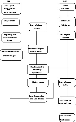
Chart 2. Flow chart for calculation of inventory result.
5.1.5 Model to Predict Tree Height, Bark Thickness and Wood Increment
The total tree heights are only measured on special sample plots, (i.e. every 4th. plot) for the other plots, tree heights are predicted from tree dbh by using a height-diameter function model. The objective is to obtain volume estimates for all the plots from tree diameter either measured or estimated tree height. The measurement of bark thickness and radial wood increment for conifers is obtained by measuring the bark thickness with a bark gauge and increment borer respectively.
The curve for predicting tree height, bark thickness, and radial wood increment from tree dbh. are fitted using regression. The calculation is done using statistical software called MINITAB2. The best fits are entered into the database in <PLOT> and calculation is done.
Volumes is calculated in <PLOT> using general and local volume equations which are available for the main tree species, and these are defined in the databases.
5.1.7 Preliminary Stratification and Calculation
Based on the inventory design, and further experiences acquired during the field work, a set of preliminary strata is define, and each sample plot that are measured in production forest are allocated to one of these strata. After doing the above mentioned steps the results are calculated, with the help of computers using the <PLOT>.
5.2 Analysis and Grouping of Forest Functions
The forest functions identified and mapped are grouped according to the management requirement;
The general management prescriptions for each category have been developed. These prescriptions are very general and more detail and specific prescriptions are drawn based on the silvicultural requirements and local condition of the forests.
Table 6. List of different forest function groups and sub-functions
|
Code |
Function Group and Sub-function |
|
S SC |
Soil Conservation Soil Conservation Soil Protection |
|
W WRR WSh WLS |
Water and Watershed Conservation Riparian Reserve Special Management Areas around Water Courses Watershed Conservation Local Water Supply |
|
N NWC NWP NB |
Nature Conservation Wildlife Conservation Wildlife Protection Special Ecological Niche Protection |
|
Soc SocLC SocL SocRS |
Social Function Social (Local cum Commercial Use) Social (Local Use Only) Religious Sites |
|
RB |
Road Buffer |
The impacts of forest functions on commercial and local use are ranked according to their management priority. In many cases, the forest functions overlaps especially those that depend on the same parameters (i.e. slope), in particulars Soil Protection, Soil Conservation and Watershed Conservation (Wsh).
Table 7 gives the functions ranked according to the restriction imposed for commercial extraction of timber from that particular area and also local uses. This Table is expected to provide the managers of the forests an idea of what can be done in a particular area.
Table 7. Impact of Forest Functions on Commercial Forest Management and Local Use
|
Rank |
Codes |
Function |
Restriction on Commercial Use |
Restriction on Local Use |
|
1 |
NB |
Special Ecological Niche Protection |
no commercial use |
no local use |
|
2 |
SP |
Soil Protection |
no commercial use |
no tree felling; no tsamdo; no shoksing |
|
3 |
WRR |
Riparian Reserve Protection |
no commercial use |
only collection of NTFP; no tsamdo; no shoksing |
|
4 |
RB |
Road Buffer |
no commercial use |
no tree felling |
|
5 |
NWP |
Wildlife Protection |
no commercial use |
restriction to activities that do not change habitat quality and disturb wildlife |
|
6 |
WLS |
Local Water Supply Protection |
no commercial use |
low impact use only; no cattle grazing |
|
7 |
SocRS |
Religious Site Protection |
no commercial use |
only uses which do not disturb sanctity of place |
|
8 |
SocL |
Social (Local Use Only) |
no commercial use |
no restriction |
|
9 |
SC |
Soil Conservation |
no clear cutting; no conversion into plantation; extension of rejuvenation periods |
low impact local use; no intensive cattle grazing |
|
10 |
WSMA |
Special Management Area around Water Courses |
no clear cutting; no conversion into plantation; minimize disturbance to understorey vegetation |
low impact local use; no intensive cattle grazing |
|
11 |
WSh |
Watershed Conservation |
no clear cutting; no conversion into plantation; minimize disturbance to understorey vegetation |
no intensive cattle grazing |
|
12 |
NWC |
Wildlife Conservation |
no clear cutting; no conversion into plantation; leave snags; leave some undisturbed patches; minimize disturbance to understorey vegetation (bamboo) |
local use should minimize disturbance to wildlife |
|
13 |
SocLC |
Social (Local cum Commercial Use) |
depends on type of local use; has to be individually determined from case to case |
no restriction |
|
14 |
Production |
no restriction |
no restriction |
In case several functions are classified for one particular forest area, then all prescribed management prescriptions are to be considered.
Based on their impact on commercial forest management the forest functions are further grouped into the following three classes (see Table 8).
Table 8. Forest function classification
|
Class 1 Protected Areas |
Class 2 No Commercial Use |
Class 3 Limited Production (commercial use restricted) |
|
Special Ecological Niche Protection Soil Protection Riparian Reserve Protection Road Buffer Wildlife Protection Local Water Supply Protection Religious Site Protection |
Social (Local Use Only) |
Soil Conservation Special Management Area around Water Courses Watershed Conservation Wildlife Conservation Social (Local cum Commercial Use) |
All areas that have no defined functions and classes are considered as production areas without any particular management restriction.
5.3 Constraints in Management Planning
Presently, the main constraint has been to obtain reliable forestry information and maps. This has become a bottleneck for the smooth implementation of this program. Some of the most pertinent information requirement vis-a-vis its gap are given below:
5.3.1 Forest Land Classification
Forest land classification is the first prescription element. This activity sets the stage and context of the activities and yield projection. It is here that we decide what we mean by heterogeneous and homogeneous forest, the individual forest types. The aspect, elevation, soil types, and drainage system are also decided.
5.3.2 Inadequate Information on Ecological and Silvicultural Characteristics of Different Forest Types
One of the major issues confronting sustainable forest resources management is the inadequate knowledge on ecological and silvicultural characteristics of different forest types, which will prevail under different treatment conditions. In addition, very little is known about traditional use of forest land and alternatives to certain unscientific use such as forest grazing by cattle.
Further, adequate information on the stand dynamics would be required. Since the dynamics of the stands are based on ecological principles which have contributed to the nature of the stand, such as succession, competition, tolerance and the concept of zone of optimum, the information on these subjects would be essential for making correct silvicultural decision.
Inducing natural regeneration in fir stands and in broadleaved forest has become very difficult. The nature does not seem to be responding to the silvicultural systems prescribed in these forest types. Even the mixed conifer stands are, sometimes, not responding properly.
Therefore, more works in this area is necessary. This work needs to be done in collaboration with other concerned divisions of the Forest Department.
5.3.3 General Volume Table Not Available
"Volume table is defined as a table showing for a given species the average contents of trees, logs or sawn timber for one or more given dimension". This dimension may be (i) dbh alone (ii) dbh and height or (iii) dbh, height and some measure of form or taper. The main objective for preparing these tables is to estimate the volume of an average standing tree of known dimensions and also to estimate the volume of a given crop or marked trees in a given coupe. Forest Resources Development Division (FRDD) has prepared local volume tables for few conifer species. More work needs to be done in this field in collaboration with other concerned agencies, in future.
5.3.4 Information on growth and yield of main species
To have accurate estimation for forecasting future yield from a forest the growth and yield table, at least, for the main species is very necessary. This table gives the yield of stand on unit area basis. Since the yield from a forest depends on several factors such as its structure, growth pattern, density, the productive capacity of the site, etc., it is necessary to understand these factors properly.
"Yield table is a tabular statement which summarizes per unit area basis all the essential data relating to the development of a fully stocked and regularly thinned even-aged crop at periodic interval covering the greater part of its useful life".
5.3.5 Inadequate Information on Non Wood Forest Products
Information on non-wood forest products is very important and need more attention.
5.3.6 Reliable information on recovery and conversion lacking
Reliable information on recovery and conversion of important timber species is lacking. Efforts are being to collect such information and develop database for the same.
6. Monitoring
Monitoring is an essential component of implementation of forest management plans and provides decision-making aid for future planning at the field level.
Resource accounting monitors
changes in the growing stock of forest stands, e.g. by harvesting
changes in the quality of forest stands, e.g. by silvicultural tending, and
the costs of field operations.
An important tool of resource accounting is the Compartment Record Book. It contains for each compartment
a site and stand description
prescriptions of forestry operations and
a proforma for recording the achievements according to cost centres.
Resource accounting is the responsibility of the forest manager. An analysis of the records at the end of a planning period reveals whether or not the planning targets of the Forest Management Plan have been adhered to and which are the consequences to be drawn for the next planning period. Thus, resource accounting monitors and controls prescribed harvesting levels and other forestry operations. It provides the database for adjustments of the targets for the following planning period.
Records on field operations enable the manager to optimize or rationalize certain field operations to improve future economic efficiency. This not only requires a documentation of the technicalities of the operations but also a clear understanding of the structure and composition of the forest at the time when the operation was carried out. Information recorded through resource accounting, thus, also supports planning.
Forest Resources Development Division in close collaboration with the Third Forestry Development Project has developed a set of forms for monitoring all the activities in the management units. The criteria and indicators has been developed that best suit the local conditions.
by
Nawang Norbu
Forest Department Bhutan
May 2000
Table of contents
1. Introduction
2. Data Collection: Types Collected, Processes Involved and Institutions Responsible
2.1. Data Management in the Forest Resources Development Division
2.2. Data Management in the Nature Conservation Division
2.3. Data Management in the Forest Protection and Utilization Division
2.4. Territorial Divisions
2.5. The Forest Development Corporation
2.6. The Forest Research System
3. Database Management: Constraints
4. Conclusion
6. References
Effective database management has become one of the most important prerequisites for the proper functioning of any organization. Proper management of databases is even more crucial in forestry in-order to ensure sustainable use and conservation of forest resources.
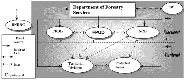
In Bhutan, the type, content and the detail of data gathered differs amongst the different functional divisions and the territorial divisions of the Department of Forestry Services (figure 1). Functional divisions like the NCD and FRDD mainly collect data to provide information on forest resource status. Territorial Divisions and the FPUD collect data on forest utilization and offense cases.
Figure 1. Set-up of the Department of Forestry Services and other Key Players
|
FRDD: Forest Resources Development Division |
FDC: Forest Development Corporation |
|
NCD: Nature Conservation Division |
RNRRC: Renewable Natural Resources Research Centre |
|
FPUD: Forest Protection & Utilization Division |
Forest Development Corporation, a corporate body, which is responsible for all the logging operations in the country, maintains their own database mainly concentrating on timber harvesting and production details.
Data collected can be classified under two broad categories:
Data collected to provide information on forest resource status; and
Data collected to determine forest resource use and depletion patterns.
2.1. Data Management in the Forest Resources Development Division
The FRDD collects data mainly for the purposes of formulating a Forest Management Plan. Information related to socio-economic aspects of forest management is also gathered. See figure 2.
Socio-economic questionnaires provide information on the following:
number of people, households and livestock within the FMUs;
total amount of private land holding in the FMU;
major form of employment and the extent of peoples dependence on forest resources
(timber, fuelwood and NWFPs);
the impact of forest management operations on the lives of the people in and around
the FMUs; and
peoples perception on: forestry practices and its effect on wildlife and ecology of the
forest.
Additional information not obtained from the inventory is collected by means of a questionnaire. Data obtained include information on the following:
silvicultural prescribe
options: whether followed properly;
site condition of the forest: in terms of weeds and damage from harvesting operations;
harvesting and transportation infrastructure: number of chainsaws, sawpits, trucks,
tractors, cable cranes and labour;
forest utilization: yield allocation; type and amount of forest produce allocated and
consumed; and
forest ecology, health and wildlife: forest cover by area and quality, incidences of
pest and disease attacks, incidences of fire, indicators for wildlife.
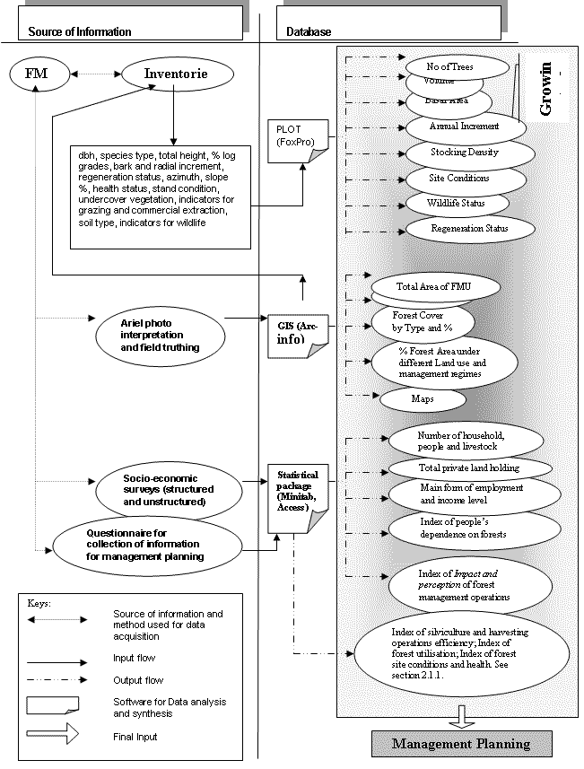
Figure 2. Data acquisition, flow, analysis and storage in FRDD
The Social Forestry Section within the FRDD maintains record on afforestation and reforestation programs carried out across the nation. The database comprises of details such as:
area planted;
species planted;
survival percentage;
number of community and private forests and related data like total area, growing
stock, location etc.
Data on non-wood forest products in terms of location, distribution, availability and uses is also collected by the FRDD.
2.1.2. Data Analysis, Storage and Retrieval Systems
Data collected from the inventory is analyzed by a software package programmed in FoxPro called PLOT (Figure 2). In the near future, the resulting databases from inventory should be linked to GIS, which will provide a comprehensive management information system (MIS), for FMUs. This will act as a kind of on-line FMU register, which will make it possible to store and derive results for a certain user defined geographical area (Laumans, 1994).
2.2 Data Management in the Nature Conservation Division
Socio-economic and biological surveys are carried out. Similar type of data as collected by the FRDD is gathered for the Protected Areas. However, details on faunal and floral abundance is collected in a much more detailed manner.
As of now, these surveys have been completed for the Jigme Dorji National Park and the Royal Manas National Park. The surveys are being carried out for the Thrumshingla National Park, the Black Mountain National Park and the Bomdeling Wildlife Sanctuary. These surveys are conducted to formulate conservation management plans for the protected areas.
2.2.2 Data Storage, Analysis and Retrieval Systems
All the data collected are stored in a FoxPro database. Plans are there to upgrade the database by using either Excel or Access software. Statistical software packages such as MINITAB is used for data analysis.
As of now, the NCD does not have a well-established GIS unit. On setting up such a unit, all the information gathered would be digitized into GIS, which will facilitate analysis and retrieval.
2.3 Data Management in the Forest Protection and Utilization Division
This Division does not carry out its own data collection surveys. Data is gathered from the different Territorial Divisions mainly focusing on forest offense cases and forest products supply.
A database has already been compiled for forest fires, with details including rate of occurrence and acreage burnt amongst others. Similar databases on the quantity of timber and other forest products supplied, along with number of forest offence cases encountered will be built.
Data is collected mainly on supply of forest produce and offense cases. Forest depot registers maintain details on number/volume of timber extracted and supplied to rural and urban consumers. There are also details available on mining and quarrying activities in Government Reserve forests.
Presently most of the Divisional databases are maintained in the form of registers. Effort is being initiated by the Thimphu Divisional Office to create a database gewog-wise on rural supply of forest produce using Excel. This could act as a model database and other Divisions could modify and adapt the structure to suit their own needs. Databases on forest offences classified according to type of cases are also maintained. Database on forest fires is well developed.
2.4.2. The Forest Range Office
Database on type of forest produce supplied along with royalty realized is maintained in the form of a revenue progress report.
2.4.3. The Dzongkhag Administration
A register is maintained on the supply of rural timber at the District Forest Extension Office, which is under the Dzongkhag administration office. A relatively underdeveloped database also exists for land exchange cases, detailing the Thram number and name of the person applying for land exchange.
2.5 The Forest Development Corporation
An extensive database related to details of timber production and utilisation is maintained by FDC. Of the many, the most important are the following:
Yearly production from various FMUs in different Dzongkhags;
Timber utilization pattern; and
Details of auction results in terms of volume, class and type of produce sold and
amount realized is also maintained.
2.5.2. Data Storage, Analysis and Retrieval Systems
All the data are stored and analyzed in LOTUS. As of now, there are no plans to upgrade the database.
2.6 The Forest Research System
The forest research component is being managed under the Department of Research and Development Services, Ministry of Agriculture. Out of the four research centres at Bajo, Yusipang, Jakar and Khangma, the Yusipang Renewable Natural Resources Research Centre has the mandate for coordinating forest research activities in the country.
The forest research program comprises of eight sub-programs:
|
Nature conservation |
Non-wood forest products |
|
Conifer forest management |
afforestation and reforestation |
|
broadleaf forest management |
social forestry |
|
wood products |
forest protection |
A detailed database is being built on each of these eight components, in terms of researches carried out, status of implementation, achievements and results obtained. Data related to observations made from research trials are also well documented. There are plans to update all databases using Excel.
Forest databases at present lack in terms of quality and details. Satellite images to calculate forest cover and other variables are not yet available. The aerial photographs that the Department has are outdated and data obtained from them are unreliable. Most of our inventory calculations are based on results of a Pre-Investment Survey, which was supported by the Government of India and carried out during 1974 1980. It covered an area of 29 176km2, about 72% of the total land area, excluding permafrost in the north. Some 78 tree species were inventoried and data mapped at a scale of 1:50000. It is the most intensive inventory carried out so far.
No analyses of any kind to determine where we have gaps in our data requirements have been carried out so far. This has happened due to the absence of an information unit within the Department.
Most of the forest databases are maintained in the form of registers. This makes analysis and retrieval of information a tedious process. The need to effectively structure these data into a computerized database is felt at all levels. However, lack not only of computer hardware resources but also of skilled manpower to maintain such databases hamper the process.
There are plans to set up an information unit for the Department. With this unit coming into action, efforts will be geared towards:
trying to assess gaps in our information needs;
developing standard formats for forest data collection for all the Divisions;
ensuring quality of data collected;
proper synthesis and analysis of data;
adequate dissemination of relevant information; and
ensuring that data collected serves the needs of the forest policy.
The use of databases cannot be stressed enough. Much of the forest data needs to be computerized to facilitate analysis and retrieval. It is to be noted that proper database management within a given Division is just one part of the solution. To utilize databases to the fullest, an effective system of networking should be established. This will soon come to fruition after the development and implementation of an Information Management System Plan for the Ministry of Agriculture. The plan is being prepared at the moment.
Laumans, P. 1994. Guidelines for Forest Management Inventory Fieldwork. Working Document No 18 (FO: DP/BHU/91/002). UNDP/FAO, DoFS, MoA, RGoB, Thimphu, Bhutan.
by
Nawang Norbu
Department of Forestry Services
Bhutan, Thimpu
May 2000
|
CSO |
Central Statistical Office |
|
DALSS |
Department of Agricultural and Livestock Services |
|
DFEO |
District Forest Extension Office/Officer |
|
DFO |
Divisional Forest Office/Officer |
|
DoFS |
Department of Forestry Services |
|
DRDS |
Department of Research and Development Services |
|
FDC |
Forest Development Corporation |
|
FMU |
Forest Management Unit |
|
FPUD |
Forest Protection and Utilisation Division |
|
FRDD |
Forest Resources Development Division |
|
LAN |
Local Area Network |
|
MoA |
Ministry of Agriculture |
|
NCD |
Nature Conservation Division |
|
NEC |
National Environmental Commission |
|
PAs |
Protected Areas |
|
RNR-RC |
Renewable Natural Resources Research Centre |
|
UNDP |
United Nations Development Programme |
1. Introduction
2. Information Flow and Users
3. Establishing a Connection
4. Information Retrieval and Management
5. Constraints
6. Conclusion
7. References
In the present age of the so-called information era, it is not uncommon to hear statements such as information is the key to all activities, and knowledge the core of strength (Struzak, 1999). Technological progress in the field of telecommunications equipment has been comprised largely of digitization, new transmission techniques, and widespread and an ever increasing use of computers. This has made data exchange, cellular and image transmission possible.
Today, Bhutan has a telecommunication network of a very high standard. There are a total of 13 active repeater stations together with 14 passive repeaters. A total of 22 terminal and exchange points connect all the Dzongkhags. Further to these exchange points, a well established network of DRMASS (Digital Radio Multi Access Subscriber System) link other areas of the kingdom. Technical plans have been finalized for the establishment of a Rural Telecom Network, which will connect all the gewogs in the country (Dorji, 2000).
Given that many databases structured and unstructured exist on forests of Bhutan in different units within the Ministry of Agriculture and outside, there is a need to link up these databases to ensure adequate flow and proper utilization to aid in sustainable management of forest resources. In the light of this, the MoA has assigned a task force to work out an Information Management System Plan. This plan will provide strategies on how to build and implement an Information Management System within the MoA.
Collection of data happens at many levels within the DoFS and outside. Networking should not only ensure connection between different bodies: information collectors and information users (Figure 1), but also make it possible for some organisations to seek information and act upon it.
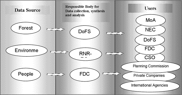
Figure 1. Information flow matrix
The Ministry of Agriculture has already established a local area network (LAN) connecting the various Departments and their Divisions in the capital. A network administration unit will also be setup, which will be responsible for managing the network, related websites and databases. Similar LANs will be set up for the RNR-RCs and its sub-stations.
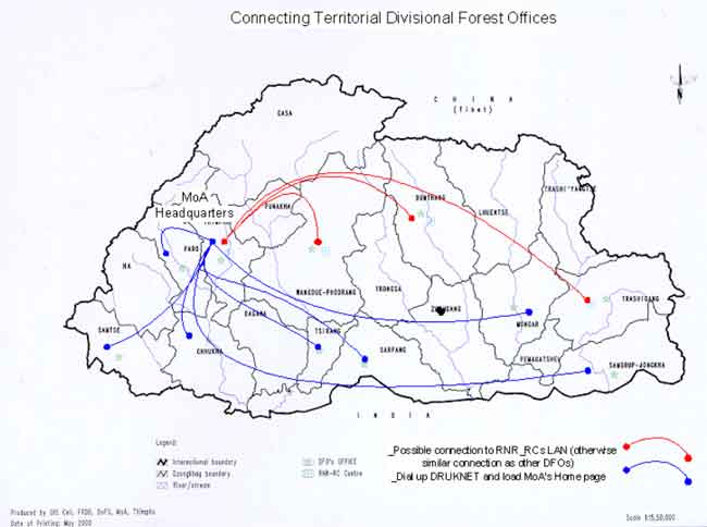
Map 1. Connecting Divisional Forest Offices to the Headquarters
These LANs of the RNR-RCs will have to get connected to the Ministrys LAN by dialing the only Internet Service Provider (DRUKNET) in the country. Though there are plans to establish dial-in facilities within the Ministrys LAN, for the time being, it is cheaper to get connected to the MoAs LAN through the DRUKNET since you get connected at local call charges.
The Thimphu Divisional Office will be connected to the Ministrys LAN directly. The Divisional Forest Offices of Jakar, Wangdue and Trashigang can be connected to the MoAs LAN through the RNR-RCs (shown by the red line in Map 1) in the same location by dial-in services established at the RNR-RCs LAN. However, where this proves to be inconvenient, like other Divisional Forest Offices (represented by the blue lines in Map1), they will have to dial-up DRUKNET and get connected to the Ministrys LAN. See Figure 2 and Map 1.
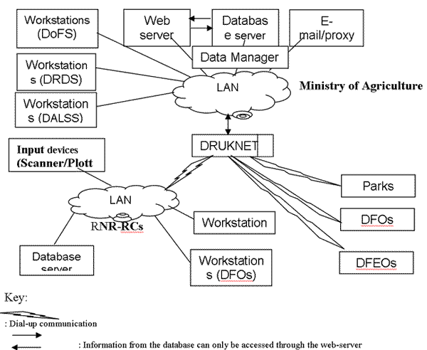
Figure 2. Ministry of Agriculture, network setup
District Forestry Extension Offices will also be connected to the Ministry in a similar way as the Divisional Forests Offices using dial-up services.
The protected areas of Bhutan will also be connected to each other and to the headquarters in Thimphu. The UNDP is planning to connect the Jigme Dorji National Park to the Ministrys LAN by using wireless technology (radio modems). The feasibility of such an establishment in terms of efficiency and cost effectiveness is presently being studied. If found to be feasible, using similar technology to set up connections in the other protected areas will be considered. However, a serious constraint in setting up such connections is the rugged terrain, which hampers radio signalling.
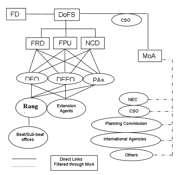
Figure 3. Linkages between DoFS and other agencies
Apart from connecting the offices within the headquarters, the divisional forest offices and the parks, connections should also be established between the Department of Forestry Services and the Forestry Development Corporation. A corporate body which deals with all the commercial timber harvesting in the country.
The DoFS and the Divisions under it will be directly connected to the DFOs, DFEOs and Protected Areas.
Connection and flow of information to outside bodies will be filtered through the MoA. There will also be connections to the RNR-RCs and the FDC from DoFS. See Figure 3.
All the forest information will be stored in a forest database within the MoAs database server. A data management team will be established and an official from the DoFS will be appointed as a member of the data management team and will have direct and full access to the Departments database server. Only he/she will have the authority to enter data in the database and make amendments.
Other users seeking data will not have direct access to the database server. They will have to retrieve required information through the web server by a query system facility, which will be provided.
The main constraints foreseen are:
(a) Monetary: in terms of costs related to setting up of infrastructure, its maintenance and overheads; and
(b) Human resources: inadequate number of personnel with adequate computer skills to set-up networking facilities and deal with computer databases effectively.
The second constraint is particularly applicable to Divisional Forest Offices where there is not only a lack of computers in terms of hardware, but also lack of computer literate personnel.
Given the well-established telecommunication system in Bhutan networking will not be a major problem. With successful networking, the proper use of forest databases in various Divisions within the Department and outside will be greatly enhanced. Divisional Forest Officers, who are also managers of Forest Management Units, can easily avail information on FMUs as and when needed from FRDD in Thimphu. The exchange of data can and should be both ways. It is planned that Managers of protected areas will also maintain their own databases that can be made use of by the offices at the headquarters in Thimphu.
In the near future with the successful taking off of the rural telecommunication network plan, it will also be possible to link the Beat and Sub-beat forest offices located in remote areas of the kingdom. Provided these offices also have a chance to maintain databases, the extent and quality of forest databases will improve greatly.
The linking of all the databases available and frequent exchange of relevant information will help in proper management of forest resources across the country. This will bring us closer towards managing forests sustainably.
Dorji, T. 2000. Director. Personal Communication. Telecom Regulatory Authority, Thimphu, Bhutan
Struzak, R. 1999. Spectrum Management. Global Communications Wireless, pp. Xii-xviii. London, UK: Hanson Cooke Limited.
W. Wik, M. 1999. Global Information Infrastructure: Threats. Global Communications Wireless, pp. 27-36. London, UK: Hanson Cooke Limited.
1 2. Number and category of functions may vary. It could be more/less depending on the local situations.
2 Statistical software.
