Vegetation classification and descriptions in the USGS land cover database are built on characteristics of vegetation seasonality determined in terms of AVHRR NDVI. In the database, unique NDVI signatures and associated attributes such as terrain and ecoregions characterise large-area land cover patterns. The magnitude of integrated NDVI over the length of the temporal period helped separate successively decreasing vegetation biomass, from healthy, dense forestlands to open woodland, shrub and grass, and sparse land cover. On the other hand, seasonal variations were investigated to partially support identification of vegetation physiognomy (e.g. separating deciduous from evergreen forests). The use of both integrated NDVI and seasonal NDVI variations has been found useful in applications such as monitoring large-area vegetation inter-annual variations (Reed et al. 1994) and mapping tropical deforestation and fragmentation (Skole and Tucker, 1993).
Because the USGS seasonal land cover database was not intended to optimize for forest cover, no direct relationship exits to enable a simple conversion of the seasonal land cover classes to the six FAO classes. Rather, a two-step methodology has been designed that allows certain interactive flexibility in deriving and correcting for the FAO classes.
§ Adapting the USGS seasonal land cover classes to the FAO classification. The full USGS seasonal land cover classes are used as the baseline data, on the continent-by-continent basis. The refinement methods to fit USGS classes to FAO definitions are similar to the methods used in producing these USGS classes, namely that refinements depend on local conditions of land cover and rely on a careful study of all available evidence. The country-level forest database maintained by FAO is also used as a general reference for country level forest classification. Loveland et al. (in press) describes the overall approach in detail. Class merges and splits are aided by ancillary data sets such as ecoregions and digital elevation models. Spectral reclustering as well as user defined polygon splits are also used. This approach has been found to be effective for many seasonal land cover classes, including most nonforest classes such as sparsely vegetated areas. However, some highly mixed land cover patterns require further analysis to differentiate both mixture conditions and the degree of forest canopy openness.
§ Estimating percent forest cover using two techniques. The concept of spectral mixture analysis quantifies pixels as fractions of basic surface components (Smith et al., 1990, Wessman et al. 1996), or “endmembers”, such as green vegetation, soil, and shade. It is generally understood that, in relatively small study areas and with sufficient spectral information, unique and representative endmembers can be identified to produce reasonable results. Unfortunately, endmember fractions do not directly correspond to forest fractions, closed forests can consist of mixtures of green vegetation, and shade (Roberts, et al., 1991). This, together with limited spectral bands and large mapping area, led to the development of a combined linear mixture modeling and NDVI scaling approach.
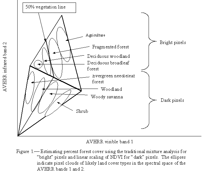
In the combined approach, the traditional unmixing method is modified slightly to apply only to bright pixels (pixels with high reflectance) in AVHRR bands 2 (infrared) and 1 (visible) spectral space. These bright pixels tend to be mixtures of forest (particularly deciduous forest), cropland, and bare soil having high reflectance in these bands. These cover types are treated as endmembers and the bright pixels are unmixed on each monthly AVHRR composite. Fraction classes range from closed forest to open forest, fragmented forest, and nonforest land cover. Dark pixels (low reflectance) in AVHRR bands 1 and 2, on the other hand, are generally found to be indicative of more undisturbed forests, particularly conifer forests. However these dense forests can be confused with low illumination or flooding. A scaled NDVI is a better indicator of forest density than mixture analysis for these dark pixels. Closed forests, open forest, and woody savanna are found to be closely related to decreasing NDVI, approximately between 0.8 and 0.3.
To provide the least atmospherically affected result, final percent forest cover is determined over the course of the year based n the maximum monthly forest cover value achieved, regardless of the methods chosen (mixture analysis or scaled NDVI). Figure 1 illustrates the two techniques used in estimating percent forest cover. The selection of endmembers and determination of what pixels are bright or dark are based on studies of the imagery and vary between regions. This modeling process is used to guide decisions on the difficult or mixed seasonal classes from the first step. The modeling process determines the level of forest fragmentation if forest density is from the modified mixture analysis; whiles separation of various types of forest and woodland from other land cover is based on results from the linear NDVI scaling. Because of varying ecological conditions within and between continents, flexible regional rules are developed according to reference data in determining forest density threshold values for the FAO forest classes.