


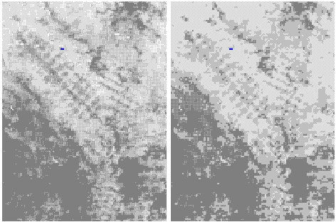
Early results have been obtained for continents of South America, Africa, and North America. For South America, for example, combined results from the two-step methodology produced a continental FAO forest cover map. Figure 2 shows an area in Bolivia, South America. The left image in the figure is estimated percent forest, the right image is derived FAO forest cover map (only three classes).
In addition to the derived forest cover map, results also include look-up tables linking the USGS seasonal land cover classes to the six-category map legend. Comparisons with the FAO forest resource information system are also made at the country level to guide the mapping work. However, it is not the objective of this effort to calculate forest area statistics based on the digital map, recognizing that, with limited spatial and spectral resolution, the data are best suited for showing where forests are, rather than quantity of forests.
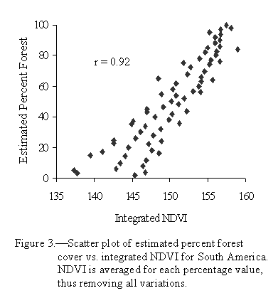
Most of the seasonal land cover classes from the USGS database were translated well into the FAO categories. For South America, for example, only 34 out of 167 seasonal classes needed further processing under the second step. Detailed attributes on most of the seasonal classes, not only land cover descriptions but also characteristics of vegetation physiognomy and canopy openness, are an advantage in aiding the translation and reclassification. In most cases, FAO forest density classes benefited from corresponding seasonal land cover classes because of integrated NDVI used for labeling process. For example, the estimated percent forest cover in South America, in average, correlates well with integrated NDVI (Figure 3).
On the other hand, there are mixed seasonal classes in the USGS database that portray co-occurrence of natural land cover patterns. Atmospheric conditions such as clouds also affect temporal patterns and cause certain seasonal classes to be mixed among different land cover types. For these mixed classes, estimating percent forest cover is a useful tool to help derive canopy-openness classes.
For the techniques of estimating percent forest cover to be effective, careful studies of regional and local land cover are very important, as is required for conventional classification methods. Due to the constraints of large mapping area and limited spectral bands, no unique endmembers can be found that will represent all typical forest cover types and densities. Therefore, regional or local stratification is necessary. In this study, existing ecoregions have been used as the primary stratification tools. However, in cases where only a small number of seasonal classes need the second step of the methodology, it is also possible that stratification is based on these seasonal classes.
Professionals from countries are also being used to validate and calibrate the maps. FAO is releasing the regional versions of the maps, as they become available, to forestry professionals participating in the FRA2000 workshops. The foresters are trained in the workshops in the protocols for map validation. Once validated the maps will then be returned with comments to FAO and EDC. EDC will use this information to revise a final map product.
Accuracy assessment has been conducted for the USGS land cover database at the IGBP 17-class level based on a set of Landsat scenes (Loveland et al., in press), with results pending. It may be reasoned that the FAO forest cover, as an associated layer of the database, would have accuracy comparable to that of the IGBP forest classes. Additional misclassification errors from this work may come from some land cover patterns such as flooded grassland causing confusions in the models used to estimate percent forest cover. A concerted effort will be made to conduct an independent accuracy assessment for the FAO mapping project, most likely using the available IGBP Landsat data set and adopting a similar validation strategy (Loveland et al., in press).
