![]()
![]()
![]()
By Mr. Kamil DILEK
INTRODUCTION
The Republic of Turkey is a passage-land between the Balkans and the Middle East 3% (Thrace) lying in Europe and 97% (Anatolia) in Asia. Bounded by six countries, and with a long coastline on the Black, Aegean and Mediterranean Seas, it consists of a narrow coastal belt backed by mountains which enclose a great plateau.
The arid plateau contains numerous lakes, many of which are alkaline and some so saline that they will not support fish. The coasts have a considerable number of lagoons which support traditional fisheries for euryhaline species.
Although primarily agricultural (albeit much of the farming is on poor terrain) Turkey's growing industrialization and urbanization has created demands on its limited water resources, and increased its pollution. With a great need for irrigation, the construction of new reservoirs, which are also used to produce hydroelectric power, has created many new static water fishing areas.
Most of the Inland commercial fisheries derive from the lakes and reservoirs on the Anatolian plateau, the remainder is principally from lagoons and other coastal areas. Crayfish, carp, eel are the major inland fishery exports. Aquaculture is developing rapidly, and sport fishing is little developed although the potentialities are there.
Turkey has 779.452 km2 area and 54.647.000 (est. 1990) population. Reside this, Turkey has 8.333 km coastline, 33 big rivers, 177.000 km in length, 200 natural lakes, 203.000 ha in size, 1.072 reservoirs, 79 dams can give opportunity to set up approximately 10.000 small reservoirs for fisheries purposes and surrounded by Black, Marmara, Aegean and Mediterranean Seas.
Total area which can be evaluated for fisheries purposes are 50 million ha (including Black Sea Economic Zone). So, the future not only for Turkey's inland and Marine Fisheries but also for lagoon fisheries, is one of expansion which will come about through adoption of more modern methods of capture, culture, processing and transport, investigation and management.
In spite of having a great water areas, unfortunately fishing is not a major economic activity in Turkey, which in 1987 ranked twenty-eight in world catch 93% of the total commercial catch was marine, mainly from the Black Sea and sea of Marmara. In general, fish has not played an important part in the Turkish diet till 1987, accounting for only about 9% of the animal protein supply or a per caput supply of about 5,8 kg/year.
PRESENT STATUS OF LAGOONS
The term lagoon refers to a coastal body of water in permanent or intermittent connection with the sea by either natural or artificial means. Lagoons are mostly shallow and contain mixohaline or brackish water and are usually quite productive biologically and having suitable ecological functions during their juvenil stages, these areas are of great importance from the fishery activities standpoint.
Lagoons represent more changeable physical and chemical features when compared to the sea. The water depth being limited; and has the special advantage of abundant organic matter and mineral salts content in terms of plant and animal species growths.
The connection between the lagoon and the sea is the most important factor from the point of view of water quality in all the lagoons. What with their connections to the sea, lagoons may be grouped as follows:
Lagoons of the same type having the same operational constructions have various productivities as a result of the different climatic areas on which they exist.
As known, Mediterranean region represents 3 climatic zones called as M1, M2 and M3 zones. M1 zone, which is at the north of the region, is called «Cold Zone» and M3 Zone, which is at the south, is called «Warm Zone». The areas from which the highest productivity is obtained in the shortest period are found between the M2 and M3 zones.
Lagoons in the Marmara Region of Turkey are found on the M2 zone, in other words on the temperate zone, having the water temperatures of lower than 15°C in winter and between 25–30°C in summer months. Lagoons in the southern Aegean and Mediterranean regions of Turkey are found on the M3 zone.
Lagoons in the Mediterranean area characteristically have a mixed population of brackish or euryhaline fishes which enter in the spring and attempt to return to the sea in autumn. Water temperatures of these lagoons are lower than 15°C in winter and above 30°C in summer months. Where considerable fresh water enters the lagoon, it may have a permanent population of fluvial fishes. Man has taken advantage of this natural inward migration by cutting off the exit of the migrants during the time of growth, and trapping or other wise harvesting the fish when they attempt to return to the sea as the season cools. Although this process is often termed «Lagoon culture», it is generally merely a form of capture fishery facilitated by the erection of fixed traps.
As a result of the fact that Turkey's Aegan and Mediterranean shores have geographic features suitable for lagoon locations, all the lagoons which have economic importance are found on these regions.
Turkey has approximately 66.000 ha lagoon areas. According to the former official records, the number of lagoons which have been operated were 33, but meanwhile the number of lagoons were on decrease due to structural modifications and some other reasons that will be considered in next pages. Major and most productive lagoons areas are approximately 41.514 ha and total production obtained from these areas 2.000 tones. The average yield for these lagoons are between 36,4 kg/ha/year to 60 kg/ha/year. This below the levels for well-tended Italian lagoos (M2 zone) on which these lagoons are found 85 kg/ha/year.
TYPES OF LAGOON CONSTRUCTIONS
Most of the lagoon weirs in Turkey are constructed from wooden material and canes. A few of them has embankments made of cement or iron (Table 1) (Fig. 1).
Most of the fish traps are made of wood and cane. The distance between canes is in general 2 – 2,5 cm. These constructions being removed, and set up each year or requiring maintenance when destroyed by the floods. They are not economic ones. A couple of lagoon units have modern fish traps made of iron, wire and wooden materials.
FISHING METHODS AND FISH SPECIES CAUGHT IN LAGOONS
The aforementioned fish traps are the main fishing equipment in most lagoons. In addition to traps, entangle and trammel nets of suitable mesh size for local fish species and pinters are in common use. ln a couple of lagoon, only lifting net traps are set up in certain periods in which fish migrations take place (Table 1 shows the fishing methods for each lagoon).
FISHING SEASON IN THE LAGOONS AND SPECIES CAUGHT
Fishing period in lagoons like other aquatic areas are determined and issued with a circular by the Ministry of Agriculture and Rural Affairs. In accordance with this circular, fishing in lagoons is forbidden and the lagoon straits are kept open to allow fish entry between the months of March and June, generally (Table 1).
Most of the landings from lagoons consist of the species of Mullet, Sea bass, Sea bream and European eel (Table 2).
Fish species caught in lagoons varies by the seasons having relation to local characteristics of lagoon environment.
Fishing seasons for fry of these species are:
| Autumn-Winter | Mullets (Flathead grey mullet, leaping grey mullet), European eel, common sole |
| Winter-Spring | Mullets (Golden grey mullet), European eel, flounder, common sole, sardine |
| Spring-Summer | Sea bream, sea bass, Mullet (Thicklip grey mullet, thinlip grey mullet, white sea bream, black tail, sardine, Striped mullet) |
Fishing seasons for adult fishes are:
| Spring-Summer | Mullet (Flathead grey mullet), common sole |
| Autumn | Mullet (Golden grey mullet), common sole, striped mullet, red mullet |
| Winter | Sea bream, sea bass, flounder, white sea bream |
MANAGEMENT TYPES OF LAGOONS
Lagoons are state owned estates and leased to the holders once allocated with two exception to the fisheries faculties to support the research activities by the Government.
Besides a few individual and incorporation, most of the lease holders are cooperatives. Cooperatives has their own fishing method in lagoons which is determined by a contract between members. Two examples of these are as follows:
the members of cooperative have to sell the whole fish caught in the lagoon to the cooperative by the determined price, but they do not have to sell the fish caught the sea to the cooperative and they may fish in the lagoon whenever they want to.
SOME TECHNICAL REASONS OF LOW PRODUCTIVITY IN LAGOONS
As a result of the accumulation of sand and suspended matters carried by the river water and the sea at the bottom, water depth of lagoons was on the decrease, moreover, in some cases the straits of lagoons have been blocked completely and lagoon areas become marshy lands.
Any improvement have not been carried out on these areas, first result was the productivity decrease due to lower water depth and less fish amount entering the lagoon and the final result inevitably the loss of lagoon area completely from the fisheries standpoint.
In some cases, the fact that the fresh water connections of lagoons have been cut off for some other purposes caused the loss of brackish water characteristics being important for juvenile fishes.
The fact that the operator lease-holders do not have required knowledge of lagoon constructions and the biology of fish species result in negative consequences. For example, if the canes in the structure of weirs are placed in the wrong way, the results is either the lack of circulation or the loss of small fishes through the openings on it. In the same way, if the lagoon operators do not have the knowledge of fish migration times some losses take place, fish traps being not set up in the required times.
RECOMMENDATIONS FOR LAGOON IMPROVEMENTS
It is also reported that as much lagoon areas as those used by extensive operations are found in Turkey.
As a first step, the fact that the present extensive operations and the lagoon areas which is out of use are transformed to the form of extensive operations with simple constructions is possible without the need for expensive investments. These type of operations may be recommended, especially in the areas in which valliculture can not implemented.
Lagoon operations of these types can be realized by the development works like the deepening to form the feeding and wintering areas the building of the circulation channels in the lagoon. These circulation channels of at least 2 m. depth and wintering area 5 m. depth are built in certain places in the lagoon. Some temporary fish traps are set up in the most appropriate places in the lagoon in certain accordance with the migration times of fishes. In case it is possible, these operations are easily improved in the form of more equipped fish farms.
As it is known the most productive lagoon operations are the valliculture (intensive fish farms systems). In the valliculture operations, lagoon area is divided some controlled parts and each part is provided with the fresh water flowed through channels. Amount of freshwater flowing into lagoon being controllable, water parameters such as salinity, temperature and oxygen, etc., can be kept at appropriate levels for fish species in lagoon. In order to built the sets between the lagoon divisions, the sand and the soil the bottom being used, the deepining of lagoon is realized at the same time.
The difference of valliculture systems from others is the fact that it also has the intensive rearing facilities combined with the other construction in the lagoon. This kind of intensive rearing facilities have been building near the two lagoon areas by the Ministry. But, they have not been completed yet.
For the practice in the extensive lagoon operations which cannot be transformed to more productive forms. In near future, following points should be taken into account:
fishing equipment appropriate for local conditions and fish species should be chosen;
Besides the aforementionned, some more precautions should be taken by the government. Some of them are:
providing financial incentives for improvement affairs of lagoons, especially for building of valliculture systems.
The major and most productive lagoons as mentioned earlier have approximately 41.514 ha total area. Operation and management types and fishing amount and species and other features of these lagoons are described in the tables 1 and 2.
CONCLUSION
In Turkey there are 10 lagoons 32.000 ha in size between 2m2 and m3 zone which is the best for lagoon fisheries. As mentioned earlier in the case of taking some technical and financial support and better management lagoon productivity can be increased from 36,4 kg/ha/year - 60 kg/ha/year up to 140 kg/ha/year - 160 kg/ha/year.
After some improvement works and in the case of increasing productivity 100 kg/ha, total fish production can be: 66.000 ha × 100 kg = 6,600.000 kg more when compared present production. So, total lagoon production can be increased at least 1,000 t in a year in a short time by taking some urgent measurements.
As a result, one thing important to do in lagoon fisheries is: at least, to move from primitive management to extensive or semi-intensive fish farm management. To achieve this goal, one pilot farm should be established as the beginning.
Finally, there is a good potential for extending the present traditional lagoon system to other areas and improving the present system by adapting a form of valliculture as is practiced on the Adriatic shore of Italy.
There is also an opportunity to culture various euryhaline species (sea bass, gilthead, mullet, etc…) in ponds and also to increase production through traditional freshwater culture.
REFERENCES SPECIFIC TO TURKEY
FAO - 1973 - Brackishwater Aquaculture in the Mediterranean Region
Studies and Reviews - № 52
FAO - 1980 - Aspects of Brackishwater fish crustacean culture in the Mediterranean - № 57
FAO - 1981 - Management of living resources in the Mediterranean
Studies and Review - № 58
FAO - 1984 - Management of coastal lagoon fisheries
Studies and Reviews - № 61 - Vol. 1
Agro-team - Project for development of Aquaculture in Güllük Area.
Vol. 1,2,3
1987- Statistical Yearbook of Turkey
Ankara : 479 p.
CATAUDELLA & FERLIN P. - 1984 - Aspects of simple technology in the management of fishery
resources and the development of aquaculture in lagoons.
In Management of coastal lagoon fisheries
TABLE 1 - LAGOON OPERATIONS
| Name of Lagoon | Type of constructions | Fishing methods in the lagoon | Period in which Fishing forbidden | Type of Management |
| Çamlik | Weirs made of wood and canes | Fish traps and nets (Aft Sept) | 15th February – 15th June | - |
| Human Bogazi | Weirs made of iron, wood and canes | .. | .. | - |
| Yelkoma | Weirs made of wood and canes | .. | .. | - |
| Akyatan | Weirs made of canent, iron, wooden mat and canes | .. | .. | - |
| Tuzla-Akdeniz | Weirs made of iron, wood and canes | .. | .. | - |
| Beymelek | .. | Permanent fish traps trammel nets, pinter | 15th March – 15th October | Cooperative |
| Karina | Weirs made of canes | Permanent fish traps Ertanglenets | June – January | .. |
| Kabahayit, Bölme, Karaca | .. | .. | .. | .. |
| Karacabey Bogazi, Dalyanve Poyraz, /Lagünü | .. | Permanent fish traps, nets, pinter | 124th February – 31st May | Private lease holder individual |
| Karacabey Ekinli Lagünü | Weirs made of wood and canes | Nets, permanent, fish traps, pinter | .. | Operated by the University of Uludag |
| Paradeniz-Akgöl | .. | .. | 15th April 10th June | Cooperative |
| Homa | .. | Permanent fish traps, trammel nets, printer | 1st April 1st June | Operated by the University of Aegean Fisheries Faculty |
| Cardak Buruniçi | Lifting net traps | Nets, pinter | - | Cooperative |
| Hersek | Permanent embankment | Nets | 15th March 15th June | Private lease holder |
| Güllül | Weir made of canes | Permanent fish traps, nets | 1st April 1st June | Cooperative |
| Köycegiz | Modern type | Permanent fish traps | 1st April 1st June | .. |
| Tuzla | .. | Nets | .. | Incorporation |
TABLE 2 - CATCHES FROM LAGOONS (Kg) BY THE SPECIES
| Fish Spp. | Mullet | Sea bass | Sea bream | European eel | Cannore sole | Carps | Catfish | - |
| Name of lagoon | ||||||||
| Çamlik | 16.724 | 12.500 | 19.000 | |||||
| Human Bogazi | 13.245 | 8.250 | 16.500 | 2.750 | ||||
| Yelkoma | 14.000 | 4.000 | 8.000 | |||||
| Akyatan | 62.500 | 37.500 | 75.000 | 12.500 | ||||
| Tuzla-Akdeniz Dalyani | 13.500 | 6.000 | 7.000 | |||||
| Beymelek | 21.000 | 3.000 | 23.000 | 15.000 | ||||
| Karina | 85.000 | 20.000 | 41.000 | 3.000 | 6.000 | |||
| Kabahayit, Bölme, Karaca | 14,000 | 5.500 | 21.500 | 300 | 300 | |||
| Karacabey Poyraz ve Dalvan Lagünü | 15.000 | 3.000 | 1.500 | 15.000 | ||||
| Ekinli | 4,000 | 500 | 1.000 | |||||
| Enez | 10.000 | 15.000 | 15.000 | 8.000 | ||||
| Paradeniz Akgöl | 27.000 | 8.000 | 5.000 | 5.000 | 1.500 | |||
| Homa | 20.000 Grey mullet | 7.000 | 25.000 | 20.000 25.000 | 30.000 Other grey mullet | |||
| Cigli, Siglar | 40.000 | 5.000 | 40.000 | 5.000 | 5.000 | |||
| Çardak Buruniçi | 3.000 | 500.000 | 5.000 | |||||
| Mert lake | 1.150 | 12.500 | ||||||
| Hersek | 8.000 | 500 | ||||||
| Tuzla | 3.000 | 200 | 200 | |||||
| Güllük | 20.000 | 5.000 | 3.000 | 18.000 20.000 | 300 | 1.500 | ||
| Köycegiz | 200.000 | 2.500 | 2.500 | 10.000 | 35.000 |
By Mr. Magd Morsi EL BAWAB
Bardawil lagoon is one of Egypt inland lake fisheres linked to the Mediterranean by two artificial-passes and one natural.
It's area is 165.000 fedan, the average water depth is (1,25) m, the salinity ranges from 42–50 ppt.
The Bardawil lagoon lies in the north coast of Senie with an extended length 90 km. There are 3.013 fishers men working in the lake; they work through 4 cooperatives.
The Bardawil lagoon represents of about 15–20% source of income of the total citizens of the government.
Bardawil has pure water due to neglegeable sources of pollutants. There are a continuous demand from the European markets for the high value fishes such as sea bass, sea bream and soles.
despite that, the total fish productivity of Bardawil lagoon represents over 0,8% of the total Egypt production.
The political executive leadership is represented by the Ministry of Agriculture, and it's General Authority for fish resources development.
It is to be noted that Egypt is lacking in fish production about 100.000 tons each year that would be needed to increase the availability for personal consumption from 6 to 8 kg/year This is presently covered through importation of public frozen fish. Meantime Egypt make is progressing in:
an export/year 3.000 ton of fishes which give concedrable income of free cash (33.000.000$);
a development plan for lakes and river Nile as well as sea fisheries, to provide an increase sources of fish production source to reach the levels required by the demand.
Fish's production in Egypt have many different source such as:
the Mediterranean, Red sea, many lakes (Elmanzale, Elberolis, Edko and Bardawil), all linked with Mediterranean sea;
other lakes: Karon, Elrayan, Maryot, High Dam in addition to the rever Nile, all that source give the most of fish production in Egypt and it has reach 340.000 tons/year.
SOURCES OF PRODUCTION IN EGYPT.
| SOURCE | PRODUCTION (tons) | PERCENTAGE | NOTE | |||
| 1 | - | Sea Fisherics: | ||||
| Mediterranean sea | 32 | - | - | |||
| Red sea | 36 | - | - | |||
| TOTAL sea fisheries | 68 | 20 | - | |||
| 2 | - | Lakes: | ||||
| Elmanzala | 57,0 | |||||
| Elberollis | 52,0 | 119,8 (TON) | ||||
| Bardaweil | 2,8 | |||||
| Edko | 8,0 | |||||
| Maryot | 1,7 | |||||
| Karon | 0,9 | |||||
| El Rayan | 0,7 | |||||
| High Dam | 22,0 | |||||
| Rever Nile | 38,0 | |||||
| TOTAL lakes | 183,1 | 53,8 | ||||
| 3 | - | Aquaculture: | 63,9 | 18,8 | ||
| 4 | - | Depretiation factor: | 25,0 | 7,4 | ||
| TOTAL PRODUCTION | 340,0 | 100,0 | ||||
Special attention should be given to Bardawil lagoon as an important source of export fishes, providing a considerable income of free cash. Bardawil lagoon share represents 60% of the total exported fishes and with a total income (15 to 20 M.$) this year.
lt is to be noticed that the total exported fish of Egypt do not exceed 1 % of it's total production.
Bardawil lagoon had over the last 33 years passed through three stages from it's political conditions.
| PERIOD | YEARS | AVERAGE | ||
| From | To | NB OF YEAR | TOTAL PRODUCT | |
| Ahmed Abo | 1958 | 1996 | 9 | 1.450 (TON) |
| Zikri Hiring | ||||
| Israel occupation | 1968 | 1979 | 13 | 1.704 (TON) |
| Egyptian Gov | 1980 | 1990 | 11 | 2.155 (TON) |
The Egyptian management period clearly shows progress due to executive and planning of the development plans (short & long terms) leading to continuous increase of the total productivity of the lagoon. The records in 1990 was 2.762 tons.
THE MAIN RESULTS CAN BE SUMMARIZED AS FOLLOWS
1- PRODUCTIVITY OF THE LAGOON
| YEAR | TOTAL PRODUCTIVITY PER (TONS) |
| 1985 | 2050 |
| 1986 | 1970 |
| 1987 | 1878 |
| 1988 | 2022 |
| 1989 | 2100 |
| 1990 | 2762 |
The maximum total productivity of lagoon was 2.762 TON in 1990.
2- EXPORTING FIELD
The table below shows the export of fish for the period 1985 – 1990.
| YEAR | EXPORTED QUANTITY PER (TONS) |
| 1985 | NOTHING |
| 1986 | 189 |
| 1987 | 550 |
| 1988 | 633 |
| 1989 | 680 |
| 1990 | 852 |
3 INCREASE IN FISHERMEN INCOME
There are a certain agreement between cooperatives and exporters on the price of exported fishes according to an international
| YEAR | VALUE OF PRODUCTION | MAIN FISHER MONTHLY INCOME |
| 1985 | 2642419 | 140 L.E. |
| 1986 | 3800180 | 191 L.E. |
| 1987 | 4715944 | 277 L.E. |
| 1988 | 8493461 | 404 L.E. |
| 1989 | 13883210 | 656 L.E. |
| 1990 | 17101715 | 777 L.E. |
It shows an increase in fishermen social level.
4- COOPERATIVES TOTAL INCOME DURING THE LAST FIVE YEARS
| YEARS | INCOME L.E. |
| 1986 | 129274 |
| 1987 | 127161 |
| 1988 | 176505 |
| 1989 | 327275 |
| 1990 | 845059 |
As a result of control in the cooperatives marking system there is an six folds increase in commission rates since 1986.
5- BARDAWIL LAGOON DEVELOPMENT COMMISSION
The table below shows the commission developing value in the period 1986 – 1990.
| YEAR | COMMISSION L.E. |
| 1986 | 660035 |
| 1987 | 1128665 |
| 1988 | 1330194 |
| 1989 | 1591454 |
| 1990 | 2231640 |
There is a period of fishing interruption in Bardawil lagoon between 4 and 5 months per year to allow fish time to grow up. There is relation between total production of Bardawil lake, rate of exported fishes and period of stop fishing in Bardawil lagoon, as in the following table.
The time of beginning of fishing and it effect on production exporting in compared with the three preceeding years.
| YEAR | START FISHING | END FISHING | NO. OF FISHING | PRODUCT PER | PRODUCTION OF THE FIRST DAY | |||||||
| TOTAL | LOCAL | % | EXPORT | % | ||||||||
| DATE | DAY | (ton) | Ton | Kg | Ton | Kg | % | Ton | Kg | % | ||
| 1987 | 11/4 | 16/12 | 199 | 1.878 | 35 | 608 | 34 | 93 | 96 | 1 | 515 | 4 |
| 1988 | 16/4 | 30/11 | 180 | 2.022 | 46 | 340 | 50 | 537 | 87 | 5 | 803 | 13 |
| 1989 | 25/3 | 15/12 | 185 | 2.100 | 33 | 540 | 30 | 119 | 90 | 3 | 421 | 10 |
| 1990 | 1/5 | 15/12 | 158 | 3.762 | 88 | 102 | 52 | 143 | 59 | 35 | 959 | 41 |
Total production and daily average production in Bardawil lagoon, (1985 to 1990).
| YEARS | TOTAL PRODUCTION | FISHING | AVERAGE | PRODUCTION/DAY |
| per ton | DAYS | TON | KG | |
| 1985 | 2.050 | 212 | 9 | 670 |
| 1986 | 1.970 | 205 | 9 | 209 |
| 1987 | 1.878 | 199 | 9 | 437 |
| 1988 | 2.023 | 185 | 11 | 238 |
| 1989 | 2.100 | 185 | 11 | 300 |
| 1990 | 2.762 | 158 | 13 | 303 |
Bardaweel lagoon, catch in 1990 by cooperative in 1990.
| COOPERATIVE | ARISH COOP. | SAHIL COOP. | SALAM COOP. | 6 OCTOBER COOP. | TOTAL | |
| NO OF BOATS | Trammel | 68 | 534 | 65 | 119 | 786 |
| verende | 12 | 6 | 36 | 110 | 164 | |
| Trawlers | 32 | - | - | - | 32 | |
| TOTAL NO OF BOATS | 112 | 540 | 101 | 229 | 982 | |
| No of FISHERMEN | 706 | 1.400 | 231 | 676 | 3.013 | |
| CATCH | ||||||
| Total | 464 | 912 | 271 | 1.114 | 2.762 | |
| 16.8% | 33% | 9.8% | 40.4% | 100% | ||
| Local consum. (tons) | 241 | 579 | 178 | 912 | 1.910 | |
| 12.6% | 30.3% | 9.3% | 47.8% | 100% | ||
| Exported (tons) | 223 | 333 | 93 | 203 | 852 | |
| 26,2% | 39,1% | 10,9% | 23,8% | 100% | ||
| EXPORT | ||||||
| % exported in the year | 48,1% | 36,5% | 4,3% | 18,2% | 30,8% | |
| Value of export in LE | 3.370.781 | 4.695.596 | 1.526.940 | 2.888.830 | 12.842.148 | |
| Total export value | 4.086.438 | 5.717.591 | 1.917.673 | 5.380.013 | 17.101.715 | |
| LOCAL CONSUMPTION | ||||||
| Average price/kg | 12,6 | 9,4 | 9,2 | 6 | 8,1 | |
| Production/day | 2 | 3,9 | 1,3 | 6,1 | 13,3 | |
| Average fishers income/year | 5.788 | 4.084 | 8.301 | 7.958 | 5.675 | |
Bardaweel lagoon production (species) compared with 3 years before.
Sea bream: the total productivity of sea bream in season 1990 was 977 Tons which represents 35,4 % of the general production.
| YEAR | TOTAL PRODUCTION | SEA BREAM AMOUNT | % |
| 1987 | 1.878,4 | 1.027 | 54,7 |
| 1988 | 2.022,8 | 1.022 | 50,5 |
| 1989 | 2.100,3 | 952 | 45,3 |
| 1990 | 2.761,9 | 976 | 35,4 |
The general average of sea bream production was 1.000 ton in one year.
The total exported productivity was 419,3 ton of first grade and 93,8 second grade which represents of about 52,6% of total sea bream production.
Mullets
The total production of mullet family in 1990 reached 1.408, about 51 % of the total production
| YEARS | TOTAL PRODUCTION TON | MULLET FAMILY PRODUCTION | % |
| 1987 | 1.878,4 | 633 | 33,7 |
| 1988 | 2.022,8 | 751 | 37,1 |
| 1989 | 2.761,9 | 1,408 | 51,0 |
Lake production of mullets was continuously increasing until it reached it's maximum in this season ith 569 ton over last year production, representing 40,4 % increase. This is the result of an increase of the number of boos gear (veraudu net) used to catch mullets. All production goes to the local consumption.
Seabass
The total production of seabass in 1990 was 185.8 tons which represents 6.71% of the production
| YEAR | TOTAL PRODUCTION TON | SEA BASS PRODUCTION | % |
| 1987 | 1.878,4 | 83,1 | 4.4 |
| 1988 | 2.022,8 | 93,9 | 4,7 |
| 1989 | 2.100,3 | 157,0 | 7,5 |
| 1990 | 2.761,9 | 185,8 | 6,7 |
The total productivity of exported fishes was 105,4 tonS which represents 83,5% of first grade and 49,8% of second grade.
Solea solea fish
The total production of sole fish in 1990 was 135 ton, it represents 4,9 % of the general production.
| YEAR | GENERAL PRODUCTION TON | SOLE PRODUCTION TON | % |
| 1987 | 1.878,4 | 70,2 | 3,7 |
| 1988 | 2.022,8 | 101,3 | 5,5 |
| 1989 | 2.100,3 | 94,4 | 4,5 |
| 1990 | 2,761,9 | 135,8 | 4,9 |
The production of sole fish increased to it's maximum rise with increasing of 41,4 ton represents 30,4%. All sizes of sole fish were exported.
Sole spawns in lake from January to February.
Groupers
This season the productivity of grouper fish was 22,5 Tons: 0,85% of the general production.
| YEAR | GENERAL PRODUCTION TON | GROUPER PRODUCT TON | % |
| 1987 | 1.878,4 | 21,9 | 1,7 |
| 1988 | 2.022,8 | 10,4 | 0,5 |
| 1989 | 2.100,3 | 13,5 | 0,6 |
| 1990 | 2.761,9 | 22,5 | 0,85 |
The exported fishes of grouper were 12,5 ton which represents 55,5% of the total productivity of this kinds.
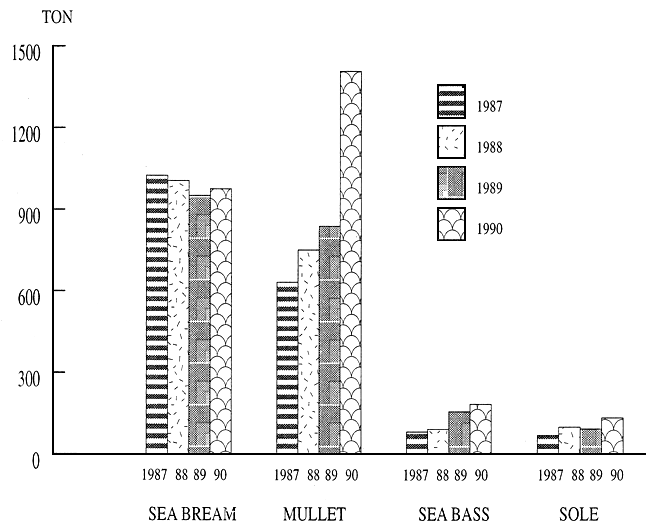
BARDAWEEL LAGOON PRODUCTION (SPECIES)
YEAR : 1987 TO 1990
| YEARS | 1987 | 1988 | 1989 | 1990 | ||||||||
| SPECIES | Percent % | Percent % | Percent % | Percent % | ||||||||
| Ton | kg | Ton | Kg | Ton | Kg | Ton | Kg | |||||
| SEA BREAM | 1.026 | 888 | 54.7 | 1.022 | 182 | 50,5 | 952 | 350 | 45,3 | 976 | 973,5 | 35,4 |
| MULLET | 633 | 27 | 33,7 | 751 | 15 | 37,1 | 839 | 830 | 40,0 | 1,408 | 431 | 51,0 |
| SEA BASS | 83 | 113 | 4,4 | 93 | 925 | 4,7 | 157 | 9 | 7,5 | 185 | 872 | 6,7 |
| SOLE | 70 | 159 | 3,73 | 101 | 319 | 5,0 | 94 | 385 | 4,5 | 135 | 856,7 | 4,9 |
| GROUPER | 21 | 926 | 1,17 | 10 | 435,5 | 0,5 | 13 | 538 | 0,6 | 22 | 517 | 0,85 |
| CRAP | 19 | 734 | 1,05 | 25 | 84 | 1,3 | 30 | 826 | 1,5 | 25 | 907 | 0,95 |
| OTHER S.P. | 23 | 575 | 1,25 | 18 | 856 | 0,9 | 12 | 383 | 0,6 | 6 | 346 | 0,2 |
| TOTAL | 1,876 | 422 | 100 | 2,022 | 817 | 100 | 2,100 | 322 | 100 | 2,761 | 903,7 | 100 |
YEARLY PRODUCTION OF DIFFERENCE SPECIES OF FISHES IN BARDAWEEL LAGOON YEAR : 87, 88, 89, 90 …
Par Mr. Abdellatif BERRAHO
INTRODUCTION
Si l'évaluation des halieutiques, qu'elles exploitées ou non, ne pose relativement pas de problèmes de méthodologie ou d'approche, pourvu que l'on dispose de données fiables; en ce qui concerne les ressources aquacoles et à moins que l'on ne soit dans le cas où tous les sites sont pleinement exploités, cas où l'évaluation revient à détermination du MSY (Potentiel Optimum Exploitable) comme pour les ressources s'avère par contre complexe.
ll s'agit en fait d'évaluer les possibilités que pourrait offrir une région ou un pays donné dans le domaine de l'aquaculture.
Ceci n'est possible qu'en prenant en compte les critères suivants; l'aspect physique du site, les facteurs biologiques et écologiques, l'aspect technologique et, enfin, le critère économique.
1- ASPECT PHYSIQUE
(géomorphologie, topographie, bathymétrie et sédimentologie)
Le première condition que l'on recherche en aquaculture, c'est la facilité d'exploitation. D'où la recherche des sites abrités de l'action mécanique de la mer (houle, vagues, tempêtes).
De même que l'on recherche des facilités dans le domaine du pompage et des amenées d'eau (le système d'alimentation en eau par gravité est particulièrement favorable). D'où la recherche des sites situés au niveau ou en dessous du niveau moyen de la mer, c'est ce qu'on appelle communément les zones bases.
Enfin, il faut que la profondeur moyenne soit convenable pour le cas de système d'élevage au-dessus du sol et que substrat soit convenable pour les systèmes d'élevage sur le sol.
Les milieux qui offrent toutes ces conditions sont en général:
les zones basses, occupées souvent par des marais salants qui peuvent être réaménagés en bassins d'élevage.
Au Maroc, les principaux sites abrités sont:
en Méditerranée:
- la lagune de Nador (114 km2), la plus grande du Maroc,
- l'estuaire de la Moulouya,
- la baie de Cala Iris;
en Atlantique:
- région de l'Atlantique au Nord de Casablanca:
- région de l'Atlantique au Sud de Casablanca:
- à signaler également la lagune de Khnifiss entre Tan-Tan et Tarfaya (lagune qui pose néanmoins des problèmes de sursalure) ainsi que la baie de Dakhla.
2- LES FACTEURS BIOLOGIQUES ET ÉCOLOGIQUES
En ce qui concerne le choix d'un site, il faut tenir en compte les paramètres suivants:
une relative stabilité des principaux paramètres écologiques, au cours de l'année, notamment pour le cas de la température, la salinité et l'oxygène dissous.
Il faut que l'amplitude de variation de ces paramètres ne s'écarte pas des limites tolérées pour l'espèce. Exemple : concernant l'oxygène dissous, il ne faut pas que le pourcentage de saturation en oxygène dissous soit inférieur à 70% pendant plusieurs jours.
Il ne faut pas que la dessalure conductive à la période pluvieuse dure trop longtemps, ou que le sur-chauffement provoqué dans les faibles profondeurs durant la saison chaude dépasse un certain seuil.
Dans le calcul du potentiel exploitable pour le cas de la conchyliculture, il faut tenir compte de la capacité de charge d'un milieu.
Cette capacité de charge se calcule à partir de plusieurs paramètres:
détermination d'un milieu semi-fermé.
Exemple: cas de la lagune de Oualidia, lagune étirée sous forme d'un chenal de 6 km × 0,4 (superficie 2,4 km2). La profondeur moyenne varie entre 1,80 m et 0,20 m en marée basse de vive eau. Le marnage est de 2 m.
La teneur moyenne mensuelle de chlorophylle a varié entre 0,2 et 10 ug/l.
Le potentiel en élevage de coquillage de cette lagune est estimé à 500 tonnes.
3- ASPECT TECHNOLOGIQUE
Cet aspect est fondamental car de lui dépendra la délimitation des zones et superficies à exploiter. De Plus, cet aspect est intimement lié au critère économique. Ainsi, plus la technologie est élaborée et sophistiquée, plus on peut étendre les possibilités en aquaculture. On peut considérer trois niveaux de développement:
exploitation des milieux abrités et zones basses par les techniques classique d'aquaculture:
élevage de crevettes en enclos.
exploitations basées à terre et alimentées en eau par des systèmes de pompage, avec apport d'aliments:
écloseries pour la production d'alevins et des post-larves de crevettes.
Dans ce dernier cas, toute la côte devient un site potentiel sous réserve de s'éloigner des sources de pollution, notamment des centres urbains et que la topographie du site, ainsi que la température et la salinité de l'eau soient favorables.
conquête de la mer ouverte:
élevage à l'abri de récifs artificiel par plusieurs types de systèmes, etc…
4- ASPECT ÉCONOMIQUE
C'est l'aspect fondamental qui déterminera la faisabilité ou la non faisabilité d'un élevage. Il dépend de plusieurs facteurs:
durée de l'élevage.
On sélectionnera les espèces (huîtres, palourdes, crevettes, algues,…) dont la durée d'élevage est relativement courte (n'excédant pas deux ans), les espèces nobles à haute valeur commerciale (ex.: loup, daurade,…), les espèces qui n'existent pas dans le milieu naturel ou n'existent qu'en faibles quantités (cas des huîtres et palourdes0, les espèces, enfin, dont le développement de la production ne peut se faire que par élevage et pouvant être valorisée de manière fort rentable (cas de certaines espèces d'algues - ex.: gelidium, gigartina, gracilaria,…).
CONCLUSION
En tenant compte des critères discutés ci-dessus, quelques exemples qu' offrent les possibilités des côtes marocaines dans le domaine de l'aquaculture se présentent comme suit:
élevage de coquillages palourdes, huîtres et accessoirement moules, dans les zones des sites où la profondeur moyenne, ainsi que le substrat, sont convenables - ex.: lagunes de Moulay Bousselham, Oualidia et Sidi Moussa;
élevage de poissons (notamment loup et daurade) en cages dans les milieux abrités qui s'y prêtent (essentiellement la lagune de Nador) et, éventuellement, la baie de Dakhla;
élevage intensif en bassins construit à terre, de loup et daurade, avec apport d'aliments et fourniture d'alevins par écloseries - ex.: estuaire de Loukkos;
élevage intensif de crevettes péneides en bassins, creusés dans la terre dans les zones basses (les marais salants pouvant être réaménagés à cette fin) (les post-larves pourraient être fournis par écloseries) - ex.: lagune de Nador, estuaire de la Moulouya, estuaire de Loukkos, salines d'Asilah, etc…
By Mr. Arian PALLUQI
Along the Albanian coast, with a total length of about 400 km, near by Adriatic sea to the North and the Ionian sea to the South, linked by the Otranto canal, there are some coastal lagoons with a total surface area of about 12.000 ha. It is estimated that the coastal lagoon environments presently exploited for fisheries that can be utilized for aquaculture represent about 9.000 ha.
These coastal lagoons are:
| 1. | Lagoon of Meerxhan | 300 ha |
| 2. | Lagoon of Ceka | 800 ha |
| 3. | Lagoon of Karavasta | 3.800 ha |
| 4. | Lagoon of Narta | 2.800 ha |
| 5. | Lagoon of Butrinti | 1.600 ha |
The fish fauna of commercial interest in Albanian coastal lagoons is mostly made up of euryhaline species such as grey mullets, eel, sea bass and sea bream.
Besides the fish species mentioned above, there are others in our lagoons. Some are resident and able to reproduce in them, others penetrate with the current flow but as they are not euryhaline, they only feed and grow inside.
With the exception of Butrinit lagoon, situated along the Ionian sea, all others are situated in the Albanian coast of the Adriatic and have the following main features:
| • | depth | 0,3 – 1,5 m |
| • | salinity | 15 – 60% |
| • | temperature | 5 – 35°C |
| • | O2 | 2 – 8 mgr/l |
| • | tide extend | 38 cm |
These hydrodynamical and hydrophysical parameters influence the trophic conditions and fish production. The average yield in lasts years (1986–1990) varied from 60 to 80 kg/ha and about 60 % of this quantity consisted on grey mullets, eel, sea bass, sea bream and the other part of 40 % are species such as Artemia and Crab.
This fish yield depends from time to time upon the interruption of the communication between the lagoons and sea, the lack of freshwater inlet, and more generally the lack of an integrated management of the coastal lagoons leads to the destruction of ecological equilibrium in these ecosystems.
The Butrinti lagoon has a depth of 20 m but all the lower layer of water below 7 m depth is characterized by a total abscence of oxygen. The lagoon communicates with the sea by a 3,8 km long canal, 100 m in width and 6 m deep. This lagoon is artificially filled with freshwater, so the salinity ranges from 18 to 30 %. During the winter period, the water temperature is not less than 10°C while in summer it often raises to 27°C. These parameters, and on the other hand the increasing of status have created optimal condition for cultivation of mussel (M. galloprovincialis).
The most common Albanian culture technique uses poles driven into the lagoon bottom and connected by ropes outside the water. Mussels are reared on vertical ropers connected to the horizontal ones. Fifty two structures for mussel culture are operated in the Butrinti lagoon with an annual yield of 4.000 tons, mostly for export and canning industry.
With regard to fish production, the average yield is the same than in other lagoons, but all fish caught are mullets, eel, sea bass, sea bream as well as dentex and corb.
The lagoons fishing gear in our country is mainly the fish barrier. This V shaped fixed fishing gear is made or reeds or plastic pipe in the main canal and serves for catching, for finfish we use trammel nets and gill nets.
PRESENT SITUATION IN OUR LAGOONS FOR AQUACULTURE DEVELOPMENT AND SOME DIFFICULTIES
Taking into consideration both present situation and fish yield in our lagoons, based on the experience of Italian aquaculture evolution, we are convinced that in our country, it is possible to take measures that starting from traditional lagoon management, can develop production strategies based on ever more complex biotechnologies.
Necessary work to be realized to pass to valiculture.
Correct hydraulic management of the lagoons
For this, it is necessary to keep always open the communication canals with the help of floating excavators and build two parallel barriers as a continuation of the channel to the sea, for our lagoons are situated between the mouth of rivers, in accumulative areas.
On the other side, for the improvement of hydrochemical and hydrophysical parameters and of the hydrobiological basis it is necessary to supply fresh water from river and artesian wells. The communication with the sea as well as the supply of fresh water will be realized artificially through sluice gate build at points of embankments where water supply canal exit.
The channel system inside lagoons
To improve the hydraulic system of water circulation and protect fish from the abrupt changes of weather, especially during winter when ice blocks the communication with fishing basin, we will build some chanal in lagoon in depending on the configuration. Near the main V shaped trap we shall built wintering chanels for fingerling.
The use of selective fishing gear
For this purpose we will replace the primitive fish barrier made up of the reeds with modern facilities of «lavoriero» type, as an advanced model will serve for a selective fishing of fish, and for the continuous supply of lagoon with fingerlings.
Sead problems
Actually, we do not feel the shortage of fry and fingerlings of grey mullets along our coast, where as for sea bass and sea bream, the problem is a bit more complex and more difficult. For this we think of a useful way, not only for the lagoons, but also to apply other forms of aquaculture, as semi-intensive aquaculture near the lagoons or the intensive rearing in floating cages, will be the construction of hatcheries near the lagoons, fristly utilizing the spawner grown up matured in lagoon.
With the process of privatization and the passing to the market economy, all the profits from this sector will be invested for its development, solving in this ways the financial problem, At the same time impulse for a rapid change in the treatment of lagoons would be given by the creation of joint ventures with foreign companies specialized in this direction.
Par Mr. Abderrahmane ABOUHALA
I - L'ÉCOSYSTÈME LAGUNAIRE
1 GÉNÉRALITÉS
1.1 Cadre géographique
La lagune de Nador-Shekha Bou Areg-est située sur le littoral nord-est marocain, entre le cap de Trois Fourches et le cap de l'Eau. Allongée parallèlement à la côte dans le sens nord-ouest/sud-est, la lagune occupe une superficie totale de 115 km2 (25km/7,5 km) et est reliée à la mer par un cordon dunaire constitué essentiellement de sable jusqu'à des profondeurs de 2 à 6 m.
La passe actuelle ou la Bokhana, qui relie la lagune à la mer, est située dans la partie médiane du cordon et est sujelle depuis quelques années à un ensablement de plus en plus inquíétant.
1.2 Bathymétrie Sédimentologie
La profondeur maximale (8 m) se situe dans le corps principal de la lagune, La pente des fonds est plus prononcée côte du cordon dunaire. Le sous bassin délimité par la presqu'île d'Alalayoun présentent des profondeurs plus faibles allant de 3 à 5 m.
Les sédiments sont des sables le long du cordon; leur extension latérale latérale sinueuse est en relation avec les migrations de la passe. Sur le reste du bassin, les sédiments sont constitués de dépôts vaseux plus ou moins carbontés, seule la bordure sud-ouest comporte des sables vaseux dont les éléments proviennent surtout du réseau des tributaires.
1.3 Hydrologie
Le bassin versant de la lagune de la lagune de Nador se caractérise par un faible réseau hydrographique très irrégulier. De faibles alimentations superficielles sont occasionnées par l'oued Selouan et les déversements du canal d'irrigation. Le bilan hydrique repose sur trois phénomènes : les échanges avec la mer (1.500 millions m3/an), l'évaporation (230 millions m3/an) et les précipitations provenant du bassin versant (230 à 500 millions m3/an).
La dérive périlittorale est de sens dextre et entraîne une lente rotation de la masse d'eau dans le même sens. En entrant dans la lagune, l'eau longe le lido en plongeant en profondeur avant d'effectuer un large virage dans l'anse de Kariat et de longer, en surface, la berge continentale de la lagune.
1.4 Climatologie
La lagune de Nador est dotée d'un climat de type Méditerranéen par des étés chauds et secs et des hivers doux et relativement humides. La moyenne des précipitations annuelles observées
á la station de Nador entre 1980 et 1990 est de 276 mm. La moyenne mensuelle de la pluviométrie, au cours de la même période, oscille entre 0,6 mm au mois de juillet et de 46,1 mm au mois de novembre, L'irrugularité des précipitations-généralement sous forme d'orage-, la faible perméabilité des sols et la nudité des bassins versants provoquent des ruissellements importants dirigés vers la lagune de Nador.
Les température de l'air de la région de Nador sont plus régulières Au cours de la période 1980 – 1990, la température a enregistré une moyenne des maximas mensuels de 22,6°C, et une moyenne des minimas mensuels de 13,7°C.
Les vents dominants, entre novembre et mai, sont de secteur WSW avec une fréquence de 24,8% sur l'ensemble des observations annuelles. Entre mai et octobre, les vents sont de dominance ENE (17,1% pour les vents de direction NNE et 15% pour les vents de direction Est). A ce régime général se superpose une alternance de brises côtières (de terre le matin et de mer l'après-midi).
2 LAGUNE DE NADOR
2.1 Factures physico-chimiques
Le suivi des facteurs physico-chimiques, liés à la courantologie et la présence d'affluents sur la berge littorale, permet d'identifier trois zones distinctes:
les deux extrémités nord-ouest (Béni Ensar) et sud-est (Kariat).
2.2 Le peuplement
Les taux de chlorophylle varient selon les stations démontrant ainsi différents niveau de production. Le maximum de biomasse est observé au niveau de Chaâla (en moyenne 11,1 mg.chla/m3), le minimum étant au niveau de la passe et de Béni Ensar (en moyenne 1,5 mg.chla/m3).
Les eaux marines, pauvres en chlorophylle, sont acheminées vers les zones de Kariat, puis le long de la berge continentale. Au cors de ce trajet, la production phytoplanctonique s'accroît progressivement. Les eaux confinées stagnent dans la zone d'ombilic avant leur évacuation progressive vers la mer.
Le peuplement, pendant la période printanière, est composé de diatomées centriques (Chaetoceros, Rhizosolenia, Skeletonema) et d'espèces nanoplanctoniques (Cryptophyceae, Chlorophyceae); le peuplement estival) est composé de diatomées centriques et pennées (Nitzschia closterium) et de péridiniens (Prorocentrum micans). Cette compositions taxonomique souligne la forte influence marine et le non confinement de la lagune, à l'exception des zones de Karait, d'Atalayoun et de Béni Ensar qui abritent des espèces indicatrices d'une stagnation des eaux (Navicules, diatomés pennées, diatomés, dinoflagellés, nanophlagellées…).
La majorité des fonds de la lagune est tapissée d'un vaste herbier mixte, Cymodcea nodosa et Caulerpa prolifera. Les extrémités plus confinées sont peuplées de Ruppia spiralis, espèce strictement paralique. Des chlorophycées (ulves et entéromorphes) sont observées le long des rives. Enfin, des zones peu étendues, dépourvues d'herbier, se situent au débouché de la passe et le long de la rive continentale.
La présence d'Echinodermes (groupe particulièrement sensible au confinement) et d'Ophiures dans les zones d'herbier à Cymodcea nodosa et Caulerpa prolifera démontre l'influence marine prépondérante sur ce vaste herbier.
L'endofaune du sédiment est représentée principalement par les polychètes: Lumbriconereis impatiens, Nerine foliosa, Eunice pennata… et les mollusques: Dentalium sp., Lucina fragilis, Tellina distorata, Abra alba…
2.3 Activités de pêche
La pêche dans la lagune de Nador est de type artisanal. Des embracations de 5 à 6 m et 8 à 25 cv sont utilisées par 2 à 3 personnes pour la pêche à l'intérieur de la lagune ou dans la Méditerranée. Les principaux engins de pêche sont les trémails et la palanza. Les captures sont assez variées mais les quantités restent visiblement très faibles. On peut trouver dans la halle de Nador des sparidés, des mulets, des crevettes, des rougets, des céphalopodes… Les anguilles et les palourdes ont un autre circuit de commercialisation.
Il faut noter qu' une partie seulement des captures est débarquée sur place. Une grande partie du poisson est vendue ailleurs. Les rendements, évalués à 8 kg/ha/an, paraissent sous-estimés.
II - LES AMÉNAGEMENTS AQUACOLES
L'AQUACULTURE : MAROST
MAROST est une société d'aquaculture crée en 1986. Elle constitue actuellement l'un des aménagements aquacoles les plus importants de la Méditerranée dont bénéficie la lagune de Nador. Les principales espèces exploitées sont:
| • | la daurande: | Sparus aurata |
| • | le loup: | Dicentrarchus labrax |
| • | l'huître plate: | Ostrea edulis |
| • | la palourde européenne: | Tapes decussatus |
| • | la crevette japonaise: | Panaeus japonicus |
| • | l'huître creuse: | Crassostrea gigas |
| • | l'anguille européenne: | Anguilla anguilla |
En 1990, MAROST possédait déjà trois écloseries pour la production contrôlée coquillages, de ses post-larves de crevettes et de ses alevins de poissons. La production totale enregistrée en 1990, toutes espèces confondues, est de 500 tonnes.
Cette diversification des espèces et ces niveaux de production ne peuvent être réalisés que dans le cadre d'une gestion rationnelle de l'écosystème qui passe avant tout par la préservation du site de la lagune de Nador.
III - LES CONTRAINTES DE L'ÉCOSYSTÈME
1 LA COMMUNICATION MER-LAGUNE
Dynamique de la passe
En 1979, à la suite d'une forte tempête, le cordon dunaire s'est brisé à peu près en son milieu pour donner naissance à la passe actuelle. La lagune était restée alors totalement fermée depuis 1977, date de la fermeture de la précédente passe.
La lagune, sous l'alternance de phénomènes naturels, a été marquée par une succession de périodes d'ouverture et de fermeture de la Bokhana. Cette évolution est caractérisée par la présence d'une seule passe naturelle à la fois et la tendance de celle-ci à se colmater dès qu'elle est formée. A certaines époques du passé, notamment lors de la conquête arabe, la lagune fut au moins en majeure partie asséchée, d'où l'appellation Sebkha Bou Areg (Sebkha = lac salé). La fermeture totale de la passe se traduit alors par une tendance prédominante à la sursalure, jusqu'à 83 gr/I (fermeture entre 1907 et 1910), et une baisse du niveau d'eau pouvant atteindre 0,7 m par an.
La fragilité de l'écosystème lagunaire et l'aboutissement au stade final de sa dynamique, un lido continu, engendrerait une lagune totalement confinée et sursalée, mettant en péril presque toute vie aquatique.
2 LA POLLUTION INDUSTRIELLE
2.1 Le Grand Nador
La population urbaine du grand Nador est estimée à 184.200 habitants. La ville de Nador est équipée d'une station d'épuration d'une capacité de 100.000 équivalents-habitants. Cette station est composée d'une unité de traitement biologique classique et d'une lagune de traitement tertiaire d'une superficie de 17 ha pour un volume maximum de 240.000 m3. A l'exception du complexe sidérurgique SONA-SID, qui est doté de sa propre station d'épuration, les autres centres et communes du grand Nador utilisent le système de puits à fond perdu ou rejettent directement dans des canaux faits pour la circonstance. A noter qu'une étude est actuellement en cours pour l'assainissement du grand Nador.
2.2 L'agriculture
La superficie totale des cultures pratiquées dans le périmètre de Nador s'élèvent à presque 8.000 ha. Les consommations en eau de ces cultures sont estimées à plus de 35.000.000 de m3. Les cultures sont assez variées, on peut trouver agrumes, oliviers, vignes, betterave, canne à sucre, céréales et cul tures fourragères… Le canal d'irrigation qui donne sur la lagune e'est fonctionnel que pendant certaines périodes de l'hiver. En été, ce canal est totalement sec.
IV - LES AMÉNAGEMENTS DE SAUVEGARDE
Dans le cadre des aménagements de sauvegarde du système lagunaire, un grand projet est prévu pour le déconfinement de la lagune de Nador. Le projet a dépassé la phase d'étude et les travaux sont programmés pour le début de l'année 1992. Ce projet a pour principal but l'élargissement et la stabilisation de la communication mer-lagune. Par ailleurs, le projet prévoit l'ouverture de deux canaux reliant la lagune à la mer au niveau de Béni Ensar et de Kariat (cf. annexes).
![]()
![]()
![]()