![]()
![]()
![]()
Information management and
coordination mechanisms
after tsunami in Aceh, Indonesia.
Udhoro Kasih Anggoro, Ministry of Agriculture, Indonesia
Rehabilitation of degraded
forest and land in tsunami affected areas in Indonesia
Saeful
Rachman, Directorate General of Land Rehabilitation and Social Forestry,
Ministry of Forestry, Indonesia
The
role of spatial information to support integrated coastal resources management
and coordination in Asian tsunami affected countries
Sugianto
Saman, National Consultant, Food and Agricultural Organization (FAO), RSCU
Lecturer, Syiah Kuala University and Tariful Islam, Land Use Planning (LUP)
& GIS Advisor, CCB-NREM Project,
Seila Task Force Secretariat
Information flow and coordination
mechanisms in rehabilitation work in Aceh: An overview of the FAO Role
Sugianto Saman, FAO Rehabilitation Support Coordination
Unit, Banda Aceh
Coordination mechanism for
recovery operations
Said Faisal, Agency of the Rehabilitation and
Reconstruction of Aceh-Nias (BRR)
Livelihoods recovery: The role
of RADA and the Income Recovery Programme (IRP)
M. Mazahim Hanifa, Livelihood Economic Recovery
Officer, Reconstruction and Development Agency
(RADA)
Information
management and coordination mechanism of the tsunami emergency and
rehabilitation operations in the agriculture sector in Sri Lanka
G.A.M. Shantha Siri
Emitiyagoda, Deputy Director Extension, Department of Agriculture Peradeniya, Sri Lanka
Information management and coordination for better
livelihoods in relation to forestry in tsunami affected areas in Sri Lanka
P.A.G.S. Nandakumara, Assistant Conservator of Forests, Forest Department,
Sri Lanka
Andaman
Forum
Simon
Wilkinson, Communications Manager, Network of Aquaculture Centres in Asia and
the Pacific and
Waraporn Prompoj, Chief of International Cooperation Group Department of
Forestry Thailand
Post-tsunami
rehabilitation coordination and information management in Thailand
Simon
Wilkinson, Communications Manager, Network of Aquaculture Centres in Asia and
the Pacific and
Waraporn Prompoj, Chief International Cooperation Group Department of
Fisheries, Thailand
Indonesia
Udhoro Kasih Anggoro
Ministry of Agriculture, Indonesia
Introduction
Immediate assistance and activities were initiated by many national and international government and non-government institutions following the devastating tsunami that hit Nanggroe Aceh Darussalam (NAD) Province and Nias of Indonesia on 26 December 2004. In February 2005, Ministry of Agriculture (MOA) the National Development Planning Board (Bappenas) developed a five-year plan (2005-2009) of agricultural rehabilitation and reconstruction for the people of NAD Province and Nias (R3MAS) in collaboration with FAO.
The plan consists of indicative activities and cost an estimated US$397.6 million. The three main components of R3MAS are (1) rehabilitation of farm capacity, recovery of rural household economy and promoting of sustainable household, (2) rehabilitation and strengthening of agriculture support services (physical and human resource assets), and (3) community empowerment, technical and institutional support. The plan was then incorporated into the national “blue book” for rehabilitation and reconstruction of NAD and Nias.
Starting in June 2005, the implementation of R3MAS has been supported by Asian Development Bank through its grant project called Earthquake and Tsunami Emergency Support Project (ETESP). In line with R3MAS, the ETESP agriculture component comprises three subcomponents, namely (1) restoration of support services, (2) community empowerment, and (3) restoration of farming. This project covers 10 affected districts in NAD Province and the island of Nias and is designed for a period of 2005-2008.
To coordinate the overall implementation of disaster management rehabilitation and reconstruction support in the affected areas and in line with the Presidential Decree issued on 29 April 2005, the Government established NAD and Nias Rehabilitation and Reconstruction Implementation Coordination Board (Badan Rehabilitasi dan Rekonstruksi NAD-Nias/BRR). With offices in Banda Aceh and Jakarta, BRR is responsible for all disaster management rehabilitation and reconstruction activities supported by any donors.
BRR manages and coordinates all activities for all development sectors including agriculture. Since agriculture sector rehabilitation and reconstruction is also supported by many institutions and donors, coordination and information management specifically in the agriculture sector is very important.
Current information management and coordination mechanisms
Information management
Agricultural development information in NAD Province and Nias comes from various sources including research and development institutions, universities, MOA, BRR, NGOs, provincial Dinases, field workers and farmers. The type of information delivered by formal institutions includes information on technology, market opportunities, pest and disease control, weather and natural disasters. The agricultural community receives this information through various media developed by agricultural institutions at district and subdistrict levels. On the other hand, the great need for information and feedback is from field workers and farmers. Below is a diagram of the agricultural information flow.
Flow of agriculture information
Coordination mechanisms
In immediate response to the tsunami disaster, MOA established a national team for natural disaster recovery with the Director General of Food Crops in command. The MOA carries out the ADB-ETESP agricultural component and the Coordination and Monitoring Unit (CMU) of the project is under the management of the Director General of Food Crops. To cover all aspects of the agricultural sector, members of the technical team of the CMU represents all line Director Generals and agencies within MOA. The structure of the Agriculture Working Group Organization for NAD and Nias Rehabilitation and Reconstruction is diagrammed below.
There are four levels of coordination for NAD and Nias Rehabilitation and Reconstruction, i.e. (1) national level, (2) provincial level, (3) district level, and (4) field level.
National level
For operations at the national level, Bappenas functions as the coordinator and for the financial aspects the coordinator is the Ministry of Finance. In addition, BRR in collaboration with FAO and ADB, also coordinates agricultural plans of action by holding seminars, workshops and meetings. Meanwhile, within the MOA, in particular the CMU of ADB-ETESP, conducts a monthly meeting for the technical team to discuss and share information on the progress of agriculture development in NAD and Nias. Monitoring and evaluation of activities implemented in the field are performed by the technical team of CMU. This unit is responsible for developing monthly reports on agricultural development in NAD Province and Nias to the Minister, who reports to cabinet.
Province level
At the provincial level, there is a Provincial Coordination and Monitoring Unit (PCMU) under the Provincial Agricultural Services Offices (Dinas of Food Crops, Estate Crop, and Livestock). Coordination meetings at this level are conducted by BRR in Banda Aceh and involve NGOs, donors, BRR and the Dinases. Topics discussed in the meeting are technical issues and problems faced in the implementation of the action plan.
Structure of agriculture working group organization
District level
The District Implementation Unit (DIU) is managed by the Head of Agriculture District Services Offices (Dinases), who coordinates all agricultural rehabilitation and reconstruction activities in the district. The activities include data and information collection of farmers and their needs for agricultural inputs, farm road rehabilitation and reconstruction, agricultural equipment, and pest and diseases management.
Field level
In some subdistricts, not all villages were affected by the tsunami. However, implementation of rehabilitation and reconstruction activities executed by donors or NGOs has to be done through local government, of which the lowest level is the village institution. It is likely that one village is assisted by many institutions and NGOs. To avoid overlapping activities, coordination between subdistricts and villages is important. In this situation, field extension workers and heads of village function as coordinators.
Obstacles in the implementation of information management and coordination mechanism
Based on field experience, there are several obstacles to data and information management. Information tends to come from formal institution (Dinases, R&D institutions) and field workers, while feedback can only be obtained from field workers (extension workers, pest observers) through their routine reports. The much needed feedback from farmers could be drawn by using participatory approaches. Meanwhile, not all institutions or NGOs are implementing participatory approaches with beneficiaries due to their project orientation, time limitation, and lack of human resource capacity.
Coordination mechanism obstacles in general are due to dynamic bureaucratic structures, such as institutional reorganization, human resource capacity in communication caused by language barriers, and inadequate infrastructure. In some cases at field level, “cash for work” programmes are carried out by various institutions and donors. However, these programmes face problems related to different rates of wages for similar types of jobs. This situation is caused by lack of coordination among programme implementers. In addition, in case of NAD Province and Nias, they have specific characteristics of ethnic groups that need to be approached with specific strategies and policies.
Recommended information management and coordination priorities for the future
Indonesia
Saeful Rachman
Directorate General of Land
Rehabilitation and Social Forestry
Ministry of Forestry, Indonesia
Introduction
Indonesian mangrove forest covers over 9 300 000 ha. About 28 percent is considered to be in good condition, about 49 percent in “ordinary” condition and 23 percent in degraded or critical condition. From field observations, mangrove forest in ordinary condition tends to become worse, although this forest is a natural resource that has a vital role for life support system.
The tsunami disaster occurred in Aceh and Nias on 26 December 2004 and has destroyed thousands of hectares of settlements, agriculture, fisheries and forest areas. However, the tsunami awakened awareness among stakeholders regarding the role of coastal forest generally and mangrove forests in particular in reducing the power of sea water on coastal lands. As a result, the Government of Indonesia is paying more attention to coastal and mangrove forest rehabilitation not only Aceh Province but also throughout Indonesia.
This paper explains the coordination mechanisms for rehabilitation of mangrove and coastal forests in Nanggroe Aceh Darussalam (NAD) Province after the tsunami.
Mangrove and coastal forests in NAD Province
The extent of mangrove and coastal forests in Nanggroe Aceh Darussalam (NAD) Province is approximately 346 843 hectares (Directorate General of Land Rehabilitation and Social Forestry, 2000). This consists of 9 percent in good condition, 83 percent in ordinary condition and 8 percent in degraded or critical condition. Detailed data is in Annex 1.
The Board of Rehabilitation and Reconstruction (BRR) of Aceh-Nias (2006) estimates that the extent of degraded forest caused by the tsunami was about 105 000 ha of mangrove forest and 67 000 ha of coastal forest. However, until now there is no precise data about the area. To improve data and information on mangrove and coastal forest condition in NAD, the Directorate General of Land Rehabilitation and Social Forestry (DG LRSF) through Watershed Management Office (BPDAS) in NAD is conducting an inventory and identification of mangrove and coastal forests in 2006. The office is also conducting spatial data arrangement of critical land (inside and outside of state own forest areas). This information will be used for planning, implementing, monitoring and evaluating of forest and land rehabilitation activities in NAD.
Coordination mechanisms of forest rehabilitation
The coordinating body responsible for handling the tsunami rehabilitation aid is the Directorate of Land Rehabilitation and Social Forestry and, when the activities involve international collaboration, the Bureau of Foreign Cooperation of Forestry Department facilitates.
Planning for rehabilitation of degraded forest and land is carried out by a combination of top-down and bottom-up approaches. First, DG LRSF extracts data and information on forest and land cover condition and acreage from land cover maps from land sat imagery interpretation, which is conducted by Forest Planning Agency. This step results in a tentative target area for every district, city and province. Second, the tentative target areas than are extended to BPDAS, Provincial and District Forest Office to be verified with Annual Technical Plan of Rehabilitation of Forest and Land. Third, BPDAS and the Provincial Forest Office than facilitates coordination and consultation among institutions involved to decide on definitive target areas for every districts and cities. This decision must be based on the institutional capacity of the local Forest Office and considers the real technical and social conditions in the field. The definitive target areas than used by DG LRSF, Ministry of Forestry for budgeting process that involve Parliament and Ministry of Finance.
Implementation of rehabilitation of forest and land is conducted by local government based on project documents approved by the central government. In this case, procurement of tree seedlings is carried out by BPDAS and planting activities is conducted by District Forest Offices and local communities. NGOs are also involved in guiding local communities especially in terms of local community capacity development. Central government also established Supervision Teams at national, provincial and district and city levels to support all activities of forest and rehabilitation in NAD. The members of the team consist of representatives from related organizations and institutions. One of the tasks of the team is to control the activities at every level to be appropriately conducted and report the progress of activities to higher levels.
BRR also conducts rehabilitation of degraded land and forests by using their own funds and work together with Provincial Forest Office. BRR established two Forestry Technical Teams, a Technical Team for Rehabilitation of Coastal Areas and Technical Team for Rehabilitation for Upland Areas. The members of the team consist of representative officers from related institutions such as Provincial, district and city Forest Offices, BPDAS and BRR. The implementation of forest and land rehabilitation is conducted by District Forest Offices, extension staff and local communities.
Coordination at national level usually occurs among the main institutions responsible for mangrove forest management in Indonesia. These are:
Lessons learned
From the emergency and rehabilitation period
From the tsunami rehabilitation period
Actions taken
Strategy to develop forestry in tsunami affected areas
Strategies with regard to coordination mechanisms and information management mechanism to develop activities in affected tsunami areas are:
Conclusion
Mangrove and coastal forests in good condition can reduce or protect people and assets from costal hazards. Therefore, rehabilitation of degraded mangrove forest and land is one of the most important rehabilitation and reconstruction activities in affected tsunami areas in Indonesia. There are many government and non-government organizations as well as communities involved in this activity. To achieve more effective results, there needs to be better information management and coordination mechanisms among stakeholders involved.
References
Department of Forestry. 2001. National Strategy for Mangrove Ecosystem Management in Indonesia. Department of Forestry. Jakarta
Department of Forestry. 2004. Implementation Guidelines for National Movement of Forest and Land Rehabilitation. Department of Forestry. Jakarta
Directorate General of Land Rehabilitation and Social Forestry, 2000. Report on Inventory and Identification of Mangrove Forest in Indonesia, Directorate General of Land Rehabilitation and Social Forestry, Jakarta
Annex 1: Potential mangrove forest and status in NAD province, Republic of Indonesia 2000
|
No. |
Province |
District |
Drainage Basin |
Priority Watershed |
Area of Mangrove Forest Based on Recent Condition and Land Status |
Total (Ha) |
|||||
|
Good (Ha) |
Ordinary (Ha) |
Degraded (Ha) |
|||||||||
|
State Forest |
Non State Forest |
State Forest |
Non State Forest |
State Forest |
Non State Forest |
||||||
|
1 |
2 |
3 |
4 |
5 |
6 |
7 |
8 |
9 |
10 |
11 |
12 |
|
1 |
NAD |
1. Aceh Besar |
Kr Aceh, Baro Ds |
I | – |
– |
1 252.62 |
25 571.16 |
– |
– |
26 823.78 |
| 2. Aceh Barat | Tripa Basee | I | – |
– |
1 190.07 |
26 715.42 |
– |
– |
27 905.49 |
||
| 3. Aceh Timur | Jambu Aye | I | – |
17 251.65 |
– |
139 823.19 |
– |
12 505.68 |
169 580.52 |
||
| 4. Aceh Utara |
Pasee, Meurudu Jambu Aye |
II | – |
12 172.77 |
– |
60 919.38 |
– |
13 911.75 |
87 003.90 |
||
|
5. Aceh Selatan |
Tripa Batee | I | – | 1 543.05 |
– |
11 312.64 |
– |
– |
12 855.69 |
||
| 6. Pidie |
Baro Ds, Meurudu |
I | – | 536.49 |
– |
21 862.71 |
– |
275.22 |
22 674.42 |
||
| Sub Total: |
31 503.96 |
2 442.69 |
286 204.50 |
– |
26 692.65 |
346 843.80 |
|||||
Data Source: Report on Inventory and I dentification of Mangrove Forest in Indonesia, Dirctorate General of Land Rehabilitation and Social Forestry, 2000.
Annex 2: Associated national institutions responsible for mangrove forest management in Indonesia
Annex 3: Implementation of Mangrove Forest Rehabilitation through National Movement of Land and Forest Rehabilitation Programme in the Affected Tsunami Area (NAD)
|
No. |
PROVINCE/DISTRICT |
WATERSHED/SUB WATERSHED |
2004 (ha) |
2005 (ha) |
|
1 |
2 |
3 |
4 |
5 |
| 1 | ACEH BARAT | KRUENG TEUNOM | – |
1 000 |
| 2 | ACEH BESAR | KRUENG ACEH | – |
300 |
| 3 | ACEH UTARA | Kr. PEUSANGAN | – |
600 |
| 4 | ACEH TENGAH | Kr. PEUSANGAN | – |
0 |
| 5 | ACEH TENGGARA | LAWE ALAS | – |
0 |
| 6 | SIMEULEUE | P. SIMEULEUE | – |
200 |
| 7 | ACEH SINGKIL | Kr. SINGKIL DS | – |
850 |
| 8 | BIREUEN | Kr. PEUSANGAN | – |
500 |
| 9 |
KOTA BANDA ACEH |
KRUENG ACEH | – |
500 |
| 10 | PIDIE | KRUENG BARO | – |
600 |
| 11 |
ACEH BARAT DAYA |
KRUENG SEMAYAM | – |
300 |
| 12 | ACEH JAYA |
Kr. SABEE-GEUPU |
– |
100 |
| 13 | ACEH SELATAN | KRUENG KLUET | – |
100 |
| 14 | ACEH TAMIANG |
Kr. TAMIANG-PEUREULAK |
– |
700 |
| 15 | ACEH TIMUR | Kr. JAMBO AYE | – |
800 |
| 16 | GAYO LUES | KRUENG TRIPA | – |
0 |
| 17 |
KOTA LANGSA |
Kr. PEUREULAK | – |
100 |
| 18 |
KOTA SABANG |
P. WEH | – |
200 |
| 19 |
KOTA LHOKSEUMAWE |
Kr. JAMBO AYE | – |
300 |
| 20 | NAGAN RAYA |
Kr. RENOM WOYLA |
– |
0 |
| 21 | BENER MERIAH | Kr. PASE | – |
0 |
|
TOTAL IN NANGROE ACEH DARUSSALAM |
0 |
7 150 |
||
Indonesia
Sugianto Saman
National Consultant, Food and Agricultural
Organization (FAO), RSCU
Lecturer,
Syiah
Kuala University
and
Tariful
Islam
Land
Use Planning (LUP) & GIS Advisor, CCB-NREM Project
Seila Task Force Secretariat
Introduction
Spatial information technology can be used in a decision support system to assist decision-making, especially in relation to coastal management and coordination. Typically, such systems will include spatial data relevant to the decisions that need to be made, analytical tools to process the data in ways meaningful for decision-makers, and outputs or display functions.
Spatial information technologies are supported by three major technologies: Global Positioning System (GPS), Remote Sensing (Airborne and Satellite), and Geographic Information Systems (GIS). These three categories are related and often employed in an integrated function. Remote sensing images and GPS data serve as inputs into GIS, which uses spatial information. Aerial and satellite images are often verified or “ground-truthed” with GPS coordinates.
Many spatial data sets are now available in distributed and web-based databases. Thus, the developments in spatial information technologies cannot be separated from the general trends in information and communication technology. This paper discusses the role of spatial information as an integrated coastal management and coordination tool.
Spatial information
Spatial information is needed to rebuild tsunami affected countries in Asia. Spatial planning, village mapping, community planning, engineering design and house building in tsunami affected areas need spatial information. Spatial information is generally information about the extent of the location. To fulfil this need, there are some issues should be addressed e.g. accurate base data, access to information, collaboration with other data providers, and maps for planning. These data can support better coordination in rehabilitation efforts.
There are three components that can support spatial information for better coordination in tsunami affected areas: Global Positioning System (GPS), Remote Sensing data, and Geographic Information System (GIS). These three components are integral part of any spatial information system that can support better planning and coordination for tsunami affected countries.
GPS
GPS is a satellite-based navigation system consisting of a network of 24 satellites, which send out continuous signals. Signals from at least three satellites allow determining a three-dimensional fix consisting of latitude, longitude and altitude of a position on the earth’s surface (Larijani. 1998, Poole. 1995a). However, the accuracy of a GPS position depends on a number of variables.
GPS has been used for quite some time in aerial and maritime navigation, and like many other electronic technologies, a gradual miniaturization of components has allowed GPS receivers to become increasingly small and affordable. As a result, uses of the technology have proliferated and include a wide range of devices for civilian and military navigation, mapping and surveying, habitat inventories and wildlife tracking, participatory land use planning (Larijani. 1998).
In regard to coordination of rehabilitation activities, GPS positions can be used to locate the rehabilitation activities. Integration with the GIS mapping, monitoring on ‘who does what and where’ can be monitor.
Remote sensing
Remote Sensing covers all techniques related to the analysis and use of data from satellites such as Meteosat, NOAA-AVHRR, Landsat, MOS-1, SPOT, ERS-1 and Soyouz and aerial photographs. Remote Sensing can be extremely useful for assessing and monitoring the condition of coastal areas, particularly in archipelagos where conventional survey techniques are usually difficult and expensive. Remote Sensing can also provide information on such topics as water quality in bays and estuaries, providing a better understanding of the ecology and biology in such areas. Remote Sensing technology could reduce the cost of collecting biophysical parameters in coastal areas compared to the traditional method of data collection, especially by ground- or sea-based systems. Furthermore, the information available at present is not adequate to permit a well-defined, geographic approach to managing the coastal environment or to distinguish between the impact of increased human activity and other impacts such as climate change. Analysis of Remote Sensing data can provide an important input to GIS.
It has been proven that Remote Sensing technology is a valuable tool for quick assessment of coastal areas damaged by tsunami waves, especially for Aceh.
GIS
The definitions of GIS are numerous but a useful one is that it is a database system in which most of the data are spatially indexed and upon which a set of procedures operates to answer queries about the spatial entities in the database. Thus, it is an information system whose relation basis is coordinate data of the form X, Y, Z; a concept familiar to the surveyor. GIS provides a structured framework for the acquisition, storage, retrieval, analysis and display of data with some common spatial or geo-referenced perspective (Parker. 1988; DOE. 1987; Burrough. 1986). The function of an information system is to improve a user’s ability to make decisions in research, planning and management; a GIS is therefore essentially a management tool. One can distinguish five general functions in a GIS: input, manipulation, management, query and analysis, and visualization (Johnson. 1997). GIS has become an integral tool in a number of applications, including environmental management, coastal management, land use planning, spatial planning and conservation.
In supporting rehabilitation activities, GIS has been used for spatial planning, monitoring of activities in health and housing in Aceh Province2
The role of spatial information for coordination effort
There is no doubt that spatial information can support coordination in rehabilitation activities. Rehabilitation and reconstruction of tsunami affected areas can be better in implementation if the local government provides:
Also, with access to spatial databases, a decision-maker can review activities more quickly and effectively.
GIS technology and coastal resource management
Determining the accurate length of the coastline is important for such coastal resource management application as shoreline classification, monitoring erosion, mapping biological resources, habitat assessment and for the planning and response to nature (e.g. storm surges) and human made disasters (e.g. oil spills). Coastal resources management, by definition, is spatial resources management. Geo-referenced spatial data is map data in a digital form, which means that each of the earth’s features that are stored as spatial data has a unique geographic reference such as latitude and longitude. The increasing use of spatial data and GIS by the organizations and researchers is a valuable tool to help solve the planning and management issues in the coastal area.
There are many different Geographic Information Systems in use today and they tend to differ in certain aspects such as “how they link geographic location with information about those locations, the accuracy with which they specify geographic location, the level of analysis they perform and the way they present information as graphic drawing”. Also most importantly how this spatial information are being communicated and understandable by all stakeholders especially non-technical map-users.
Why GIS for integrated coastal management
Coastlines all around the world are developing rapidly and firm management policies have to be established. However, for any management of the shore to be effective, it is necessary for the policies to be based on informed decision-making. This in turn requires ready access to appropriate, reliable and timely data and information, in suitable form for the task at hand. Since much of this information and data is likely to have spatial components, this is one branch of information technology with potential for contributing significantly to coastal management in a number of ways. These include:
Some aspects of spatial data requirement
Data accuracy is a problem in Spatial Information System or GIS. This requires consideration of both object oriented and field oriented views of geographic variations. Other factors such as the type of spatial data, the scale and resolution of the spatial data, the type of map projection, the measuring unit, horizontal and vertical datum for geographic coordinates, and metadata also must be considered.
Information requirements for sustainable coastal resource management
To be of any value, it is necessary that the information products output from a coastal resources management should correspond with the actual requirements of the various user communities. But what are these information requirements?
Given a number of potential users of coastal area data and information, what are the main areas of common interest or significant diversity - regarding both information desired, and the data needed to be processed in order to obtain that information?
Data required for coastal area fnformation
Geographical data: Many of the data to be found within a coastal management database will be geographic in nature and can be called geographical data. It is a “datum”, which refers specially to features that describe the earth’s surface (Figure 2 showing different layers of GIS). Geographical data has both location and attributes. This is the “Where” something is and the “What” it is? We can define the where something is as the Spatial component of data, and what something is as the a spatial or attribute component of data.
Classification of coastal information data: Thus, many coastal databases will, in potential or in reality, display many classic characteristics of databases found in GIS. As with any other GIS applications, the data involved in creating a coastal GIS database fall into a number of distinct categories. Depending on the method of classification used, these include: basic geodetic or planimetric data, topographic data, qualitative and quantitative attribute data, time series data and metadata
Sources of coastal information data: As identified above, two types of data are input into a GIS, spatial and attribute. A wide variety of data sources exist for both spatial and attribute data.
Sources of spatial data
The most common general sources for spatial data are:
Sources of attribute data
Attribute data has an even wider variety of data sources. Any textual or tabular data that can be referenced to geographic features, e.g. a point, line, or area, can be input into a GIS. Attribute data is usually input by manual keying or via a bulk loading utility of the Data Base Management System (DBMS) software. ASCII format is a de facto standard for the transfer and conversion of attribute information.
Key issues relevant to use of spatial information system in ICRM
Although there are currently detailed onshore maps (topography) and offshore charts (bathymetry), but there are few standardized uniform geospatial products, either maps or charts, that integrate the two in tsunami affected coastal areas of Asian countries. Differences in scale, resolution, mapping conventions, and reference data (horizontal and vertical frames of reference for mapping) prohibit the seamless combination of existing onshore and offshore data. This lack of accurate coastal area maps is a serious impediment for coastal managers. Further, the lack of standardization and coordination of coastal zone data has led government agencies, the research community, and the private sector to generate new data and maps for almost all new studies and initiatives, in some cases duplicating efforts. It is also lacking in standard data collection procedures and, most importantly, how this spatial information system can be used in participatory land use planning and sustainable development.
Recognizing this situation, it is essential for developing “A Geospatial Framework for the Coastal Areas” that identifies needs and makes recommendations in three areas: a) producing onshore/ offshore maps; b) improving coordination among those doing coastal mapping; and, c) increased data collection. It will enable to develop spatial planning tools (e.g. PLUP for agricultural development) to support post-rehabilitation reconstruction and development works in tsunami affected coastal areas.
Use of spatial information in integrated land use planning for ICRM
Uncontrolled/unplanned land use is taking place throughout the developing countries and tsunami affected coastal areas are no different, in fact, rather worse in some places where fast development has been taking place. Thus, forest/land clearing and degradation is an ongoing process and the speed of clearing is increasing. There is a strong link between road improvement, waterways and forest clearance. Such development has an enormous impact on the quality of the remaining natural resources. These conditions affect the livelihoods of many communities because their dependencies on these resources are still strong. Secure and sufficient access to land and resources are crucial to raise income and provide livelihood options for those who depend on these resources on a daily basis, especially where alternative options are limited.
Effective use of maps (and spatial information) in integrated land use planning and natural resource management
The Use of maps and spatial information in natural resource management and land use planning is essential to improve sustainable and equitable use of land and natural resources, through participatory community and local level planning and investment. Factors which lead to effective community-based land use planning and natural resource management include:
Maps and participatory mapping processes can be used to support all of these factors, as illustrated in the diagram in Figure 1.
Figure 1: Some of the ways in which maps and mapping processes can facilitate effective land use planning and natural resource management
Summary and conclusion
Poorly managed economic development in coastal areas is likely to create serious problems related to environment. One solution to this problem is through the Integrated Coastal Resource Management approach. ICRM must be aimed at maximizing synergistic and complementary interactions and minimizing competitive and antagonistic ones. Appropriate policies and strategies are essential for successful implementation an ICRM approach.
Key lessons learned from spatial information perspective are:
Recommendations
Spatial information should be viewed as an opportunity for the coastal communities. The ultimate objective of a spatial information systems for natural resources management is, or should be, to improve planning and decision-making processes by providing useful and scientifically sound information to the actors involved in these processes, including public officials, planners and scientists, and the general public. Information must be 1) timely in relation to the dynamics of the decision problem and accurate in relation to the information requirements, 2) requires the use of state-of-the-art tools, methods, and models, and the necessary input data, 3) and directly understandable and useful.
GIS technology as integral part of spatial information should be applied to create spatial information and use them in spatial planning. It should be done step by step. Some basic steps in spatial planning for post-tsunami coastal areas are proposed as follows:
Data dissemination
For non-GIS people: Thematic maps prepared in A4 or A3 size in JPEG or PDF format for printing and shall be opened to the public through the internet websites (e.g. BRR website) for access to the maps by all map users. However, for map use at community level, A0 size would be very effective and useful.
For GIS experts: Digital GIS datasets shall be updated and exchanged among the persons/ organizations concerned with post-tsunami rehabilitation and reconstruction related planning and development (e.g. of Banda Aceh City).
Table 1: Recommended spatial planning activities for tsunami affected coastal areas
|
Activity |
Required data |
|
Grasping trends and changes at various aspects before and after the tsunami event, quantitatively e.g. population, infrastructures, houses/buildings, facilities, land cover/land use, human activities |
High resolution
satellite imagery before/after Existing |
|
Setting spatial unit for analysis (village level) |
Administrative boundaries (City/district/Subdistrict, village, and adjacent areas) |
|
Estimating future population growth in coastal area |
Population/census data (non-spatial data) by village |
|
Expecting urbanization, human, economic and development activities in future |
Population/census data (non-spatial data) by village |
|
Estimating demands in each sector |
Based on expectations and analyses with criteria and related policies |
|
Allocating necessary infrastructures and facilities spatially |
Based on further expectations and plans, and simulations with GIS |
|
Preparing spatial plans (with planning maps) |
Land use map, ITK, and Monitoring, etc. with GIS |
Other issues
Sustainability: The database might be updated periodically by skilled and responsible GIS people (e.g. trained local GIS expert work for GIS unit of BRR).
Capacity building: GIS is relatively new technology for many public sectors. Therefore, GIS-related training should be planned and given by an appropriate organization (e.g. UNSYIAH) to the GIS staff (e.g. BRR), facilitators regularly and arrange introductory/basic training on map use to the involved community.
Organizational development: It should not put emphases not only on production of map and database but on 1) human-development, 2) improving management skills, and 3) more skilled on utilization of GIS in their next activities.
References
Burrough P.A. (1986) Principles of Geographical Information Systems for Land Resources Assessment. Monographs on Soil and Resources Survey, Oxford: Clarendon Press, 193 pp.
Cicin-Sain, Biliana and RW Knecht (1998) Integrated Coastal and Ocean Management: Concepts Practices. Washington, WA. Island Press.
Clark, J.R. (1997) Coastal Zone Management for the New Century. Ocean & Coastal Management. 37(2): 191-216.
Clark, J.R. (1996) Coastal Zone Management Handbook. Florida, Fl. Lewis Publishers.
DOE (Department of Environment) (1987) Handling Geographic Information. HSMO, London.
FAO (Food and Agriculture Organization of the United Nations) (1996) Agro-ecological zoning -Guidelines. FAO Soils Bulletin 73. Rome, Italy.
Harris, T. and D. Weiner (1998a) Community-Integrated GIS for Land Reform in Mpumalanga Province, South Africa. http://www.ncgia.ucsb.edu/varenius/ppgis/papers/harris.html
____ . (1998b) Empowerment, Marginalization and “Community-integrated” GIS. Cartography
and Geographic Information Systems 25(2): 67-76.
Humphreys R.G. (1989) “Marine Information System” the Hydrographic Journal No. 54 Oct. 1989.
Ignas Dummer. (2004) Information and Knowledge Based System for Land Suitability Analysis in Cambodia. In: Proceedings on Land Resource Assessment Forum for Cambodia. pp. 59-74; September 14-17, 2004, CARDI, Phnom Penh, Cambodia.
Johnson, B. (1997) The Use of Geographic Information Systems (GIS) by First Nations.
Joshi M.D. and R. Shivakumar (2000) “Some aspects of Accuracy in GIS” GIS@Development Vol. 2 Issue 2.
Krola Natural Resources Management Committee (2002) Community Land Use Planning: A case study from Krola Village, Ratanakiri, Cambodia. Non-Timber Forest Products (NTFP) Project.
Kurt Fedra & Endrico Fedli. “GIS technology and special analysis in Coastal Zone Management” by EEZ Technology Edition 3.
Kyem, P. (1998) Promoting Local Community Participation in Forest Management through the Application of a Geographic Information System: a PPGIS Experience from Southern Ghana.
Larijani, L. (1998) GPS for Everyone. American Interface Corp, New York.
Parker, H.D. (1988) The unique qualities of geographic information system: a commentary. Photogrammetric Engineering and Remote Sensing, 54: 1547-1549.
Pickles, J., ed. (1995) Ground Truth: The Social Implications of Geographic Information Systems. Guilford Press, New York.
Poole, P. (1995a) Guide to the Technology. Cultural Survival Quarterly 18(4): 16-18.
Robin K.H. Falconer (1990) “Experience with Geographic Information System (GIS) in the marine world”. Hydrographic Journal No. 58 Oct. 1990.
Rock F., ed. (2001) Participatory Land Use Planning (PLUP) in Rural Cambodia: Manual for government staff and development workers. Ministry of Land Management, Urban Planning and Construction.
Sirait, M. et al. (1999) Mapping Customary Land in East Kalimantan, Indonesia: A Tool for Forest Management (9 February 1999). http://envgov.ewc.hawaii.edu/env/working.papers/jfox/ kali.html
Indonesia
Sugianto Saman
FAO Rehabilitation Support Coordination Unit
Banda Aceh
Background
The extent of the damage of the catastrophe that struck Asia on 26 December 2004 is well documented. In Nanggroe Aceh Darussalam (NAD) 129 2713 people were killed, more than 566 8984 displaced and 750 000 partially or totally lost their livelihoods. To deal with this disaster, a review of national capacities in relation to coordination structures must take into account not only the devastation of physical infrastructure, but also the personal trauma, loss of family members and property, and collapse of systems of government, banking and commerce.
As part of the UN mandate for rehabilitation activities, FAO has been involved in the emergency relief effort. FAO has been providing advisory and coordination support to the Bureau for Rehabilitation and Reconstruction (BRR) of the Government of Indonesia in the agriculture, fisheries and forestry sectors. FAO has been 1) promoting the effectiveness and levels of access to coordination/common services; 2) increasing the efficiency of humanitarian assistance for better information gathering and dissemination; 3) advising on the extent to which decisions and advocacy are based on accurate information and analysis, especially for delivering inputs in agriculture, fisheries and forestry sectors and 4) facilitating the efficiency of dispatch of humanitarian aid through the FAO activities during emergency and rehabilitation phase.
This paper offers an overview of the information management and coordination mechanism for early recovery. It highlights common information flows and coordination mechanisms in Indonesia for rehabilitation and reconstruction of tsunami affected areas, the role of FAO in improving coordination mechanisms in agriculture, fisheries and forestry sector and the activities to support better information flow and coordination mechanism under the FAO OSRO/RAS/503/CHA project.
Information flow
Under coordination of BRR, UN agency and NGOs as well government agencies, the pace of rehabilitation and reconstruction has speeded up but there exist overlaps and inconsistent messages going to the public due to information gaps and coordination issues. In regard to these issues, FAO initiated a project entitled “Regional information management and coordination on strategies for early recovery of agriculture in coastal regions”. The activities related to the information management and coordination have been implemented through training, workshop, to strengthen the capacity of government officers in Aceh.
The information which was used as a basis to review and assess the management of information for emergency effort will cover six key aspects, there are 1) availability, 2) understandability, 3) use, 4) completeness, 5) accuracy, and 6) up-to-date. All these aspects are needed to support an emergency and rehabilitation effort. The information flow in relation to rehabilitation activities is summarized below.
Information flow and use within BRR and Provincial Dinases
The development of the Recovery Aceh Nias (RAN) database was designed to strengthen the performance of the Bureau of Rehabilitation and Reconstruction (BRR) in tracking activities of every organization involved in recovery matched against identified needs. It is a welcome development. The information centre in BRR, of which the RAN database is integral part, has essential project information captured from project documents processed and approved by the BRR (organization, location, title, purpose, budget, and target). The information has been uploaded to the RAN database. In this way, BRR and the involved organizations will have access to a solid information base that can support the overall reconstruction process to measure progress, identify gaps, address implementation problems and improve planning of interventions. Gathering information from all organizations, the RAN will be able to provide comprehensive data of the flow of funds mobilized to respond to the tsunami.
However, organizations are supposed to report back “actual” achievement, but there was very little update of actual physical accomplishments in the beginning of the rehabilitation. This is now is improving. Also, a limited evaluation unit exists within BRR to (1) cross check and validate accuracy of data (2) undertake evaluation and impact assessment work. These limitations are weakening the information flow. However, key performance indicators have been established to assess the rehabilitation activities. These reveal that there is a need for the development of an agreed standard set of KPIs for progress and impact assessment for BRR projects.
The use of the RAN database is limited at the district level. This is due to the lack of information technology infrastructure and equipment in the district to access the internet connection. In addition, the Spatial Information and Mapping Centre, SIM-C at BRR has been established since February 2006. The unit compiles documents and maps using existing information given to it. It does not, however, seek primary data or information itself. It is a common case that staff in offices are unaware of the extent of development in their disciplines, especially with regard to what has been undertaken by NGOs independently of their office. Dinases at provincial level also do not know exactly what NGOs are doing in the field, even though the activities are under Dinas working areas.
District level
Feedback from various Dinases from Districts tells us that they were not well informed about rehabilitation and reconstruction. Mostly, the staff interviewed want more coordination and information on rehabilitation in each subsector to create sustainable development. Dinases did not know that a database had been developed by BRR that they could use as a source of information for NGOs and agencies in implementing their programmes in the field.
The involvement of Dinases is important to support the rehabilitation programme. Previous assumptions of NGOs is that staff in dinases are not well trained for such activities, but they actually have the capacity to work with NGOs and agencies in implementing the programme on rehabilitation and reconstruction. They have the ability to develop good communication and coordination channel related to their expertise. They need capacity building information and coordination for rehabilitation activities in their districts. They felt passed by all decisions made by provinces or BRR. To overcome this problem, BRR is now starting to consider the involvement of the districts through representative personnel from each district and regional office of BRR that can cover two or three districts.
Dinas
In terms of information flow and use, the agriculture, fisheries and forestry dinases actively collect information from different sources (newspaper clippings, BRR). Some Dinases provide a room for NGOs and other agencies in the office to support the rehabilitation activities in the district. A Completion Report form on the physical completion of projects by all organizations is a mandatory submission to the Dinas.
Board Planning (Bappeda)
Within Board Planning at province and district level revealed no involvement of implementation and reporting for the NGO activities to this office. However, the board staff actively collect the data from the Dinas for rehabilitation and implementation aid. Limited access to rehabilitation information from other Dinases about the activities, and the data are overloaded and mixed. Actually, Bappeda has a master plan for rehabilitation within the district, but few agencies use it. Thus, there is a need to fill these information gaps and review information flow and use the information from Bappeda.
NGOs
The key finding from NGOs interviewed revealed that coordination is the main issue in implementing their programmes. A lot of activities on rehabilitation and implementation of the programmes were not reported to Dinas and local government. Some activities were overlapping with others. Some NGOs staffs responsible for reporting activities did not know about the RAN database and some have collected initial data from the field and promised to implement what the communities need, but in reality they do not implement what they promise. This has an impact on the trust communities have in NGOs who want to implement in the field.
From spatial information group meetings we learned that some NGOs asked for more updated data and coordination. BRR should take a lead for coordination and data updating.
Coordination mechanisms
Government coordination structure
Humanitarian relief coordination is based on the belief that a coherent approach to emergency response will maximize its benefits and minimize potential difficulties. The emergency and relief operations in Nanggroe Aceh Darussalam where managed through a structure created directly under the President of Indonesia. A National Coordination Body (Bakornas: Badan Koordinasi Nasional) at national level, Implementation Coordination Committee (Satkorlak: Satuan Kordinasi Pelaksana) at provincial level and an Implementation Committee (Satlak: Satuan Pelaksana) at district level managed civil and military assistance and contributions.
During this initial period, the Government of Indonesia used a Coordinating Committee under the national Development Planning Agency (BAPPENAS) which was in charge of coordination of the organizations providing assistance until the Rehabilitation and Reconstruction Agency for Aceh and Nias (BRR) was formed to take care of the rehabilitation and reconstruction activities.
The local government structure comprises the city or district administration headed by the Mayor (Walikota or Regent/Bupati in rural areas), followed downwards by the Subdistrict (Kecamatan) headed by the Camat, the village head (Keucik) and neighbourhood headed by the Kepala Lorong.
During this 22 month phase, assistance came directly from the organizations and UN agencies to the affected communities in the NAD comprise in two areas; West Coast and East Coast. The West Coast was more affected compared to the East Coast, but the rehabilitation activities concentrated on the East Coast. For instance, there were 252 rehabilitation activities in Pidie and Biruen combined, compared to only 165 activities for Aceh Jaya, Aceh Barat and Nagan Raya districts for rehabilitation in the sector of agriculture, fisheries and Forestry5.
In respect to INGOs, national authorities had limited knowledge and understanding of the complexity, culture, policies, procedures, and working mechanisms of international relief organizations, and vice versa. Most INGOs were not known to government officials, and there was no clearly defined liaison mechanism established between the Government of Indonesia and INGOs. Neither was there a shared understanding of terminology, definitions, and standards. The Indonesian Government’s decision to restrict the presence of INGOs after three months led to feelings of disillusionment among relief agencies, and to a decrease in or discontinuation of much-needed assistance programmes6. This situation continued until the BRR was formed in April 2005 when the recovery phase was begun.
The establishment of BRR has received full support from Indonesian Parliament. Since then, BRR has taken a lead in coordination and rehabilitation activities. There are some problems with collaboration as the BRR has exceptional resources and power although only a 4-year mandate. With the lifting of the State of Emergency and the consequent lessening of authority under the regional government and military nexus, the international community has welcomed the creation of the BRR and begun investing in the BRR as the pre-eminent coordinating authority for reconstruction. Indeed, the BRR’s remit includes transparency, attracting support locally as well as international.
After 22 months, the most important lesson learned is that governments have to be prepared in advance for disasters, putting in place adequate resources to develop appropriate policies and mechanisms to reduce risks, to prevent them or to effectively deal with them when that is the case.
BRR coordination
BRR together with international NGOs and UN agencies such as FAO, UNDP, UNORC, UNICEF, UNOCHA, UN-Habitat, UNHCR, UN-ILO, UNOPS, UN-WHO, UN-FPA and UN-WFP have been recognized as mandated organizations on transition from emergency to rehabilitation stage for Naggroe Aceh Darussalam. Under coordination of BRR, UN agencies and NGOs and government agencies, the pace of rehabilitation and reconstruction has speeded up the rehabilitation effort, but there exist overlaps and inconsistent messages going to the public due to information gaps and coordination issues.
Since BRR was formed, the coordination mechanisms of rehabilitation and reconstruction of Aceh Nias is under BRR. To oversee the coordination mechanism, BRR has been applying a Coordination Mechanism 7 through the activities as follows:
The Concept Note is to be submitted to BRR and assessed. The proposed activities are usually initiated by NGOs, UN agencies and donors. There is a team from BRR, UN and other agencies to have regular steering committee meetings to discuses any issued related to rehabilitation activities within the sector such as agriculture, fisheries and forestry.
The involvement of BRR and other agencies such as AusAid, UN-ORC and FAO activities under regional information management project has strengthened the capacity building of government staff. NGOs’ response to the RAN database also has encouraged the coordination mechanism to oversee the rehabilitation activities.
Coordination mechanism of FAO
The coordination mechanism of FAO Banda Aceh is an important aspect of appropriate, effective, efficient and coherent delivery of humanitarian services. It involves the systematic use of policy instruments including:
In this sense, the coordination mechanism in FAO-Banda Aceh shows a subordinate structure between HQ, regional, national and Unit. Unit is a special case for emergency efforts. This mechanism is depicted in the following diagram.
FAO RSCU Banda Aceh activities to support better coordination
FAO RSCU Banda Aceh plays an important role in supporting the emergency and rehabilitation phases for Aceh and Nias. FAO has implemented many projects funded by different countries within three main sectors: agriculture, fisheries and forestry.
In regard to regional information management and coordination projects; collecting information on coordination mechanisms has been the main activity for Indonesia. Also, strengthening capacity building of government staff through computer training and creating databases in fisheries sector.
Study on rehabilitation activities and coordination mechanism
The study on rehabilitation activities and coordination mechanisms is expected to provide information for government for the development of management information systems at district level through database analysis with system GIS.
Figure: Flow diagram of FAO RSCU Banda Aceh coordination mechanism
The scope of activities include Pidie, Biruen, Aceh Jaya, West Aceh, and Nagan Raya districts surveyed on rehabilitation activities, and coordination mechanisms within these districts, and creating the database concerning activity rehabilitation in Pidie, Biruen, Aceh Jaya, West Aceh, and Nagan Raya by using GIS. A final report of these activities will show the rehabilitation activities in the sector of agriculture, fisheries and forestry. Coordination mechanisms in term of the NGO reporting activities also presented.
Training on computer literacy, information management and data collection
Computer training sessions on basic Microsoft applications (Word, Excel, PowerPoint and Access) have successfully trained 80 people from five different districts from agriculture, fisheries, forestry, Dinas and Bappeda. The main goal of this activity is to strengthen the capacity of government officers to manage information and better coordination in rehabilitation. This goal can be achieved if the staff have the skills to use these applications effectively.
A follow-up study on the computer training reveals that many officers in the district Dinas could not previously operate a computer. Thus, the activities created through OSRO/RAS/503/CHA have had a positive impact on government officers.
Support for information technology
As a follow-up to the computer training, OSRO/RAS/503/CHA project purchased computer packages for the district Dinas. Even though the units of computer are limited, the project has an impact on better information management and coordination mechanisms. The computer donation to Dinas is welcomed.
Workshop on information and coordination activities
The workshop has brought together most coordination bodies of rehabilitation effort from subdistricts, district, province, central government and BRR. The main topic of this workshop is the role of coordination and information management mechanism for early recovery of agriculture, fisheries and forestry and rehabilitation of tsunami affected area in NAD, Indonesia.
The objectives are to review the information management and coordination efforts in the aftermath of the tsunami of affected areas in Aceh, the role of UN agencies, NGOs in coordination of rehabilitation activities in the sectors of Agriculture, Fisheries and Forestry.
Inventory of spatial data for fisheries sector (seconded to BRR)
This activity was to create an inventory of relevant existing spatial data and information collected by BRR, FAO, and relevant ministries, Departments and Districts for the fisheries sector. The task includes collecting, sorting, cleaning data, create geodatabase and metadata.
Summary and conclusions
FAO RSCU Banda Aceh has been involved in emergency effort for early recovery. The role of FAO in improving coordination mechanism in agriculture, fisheries and forestry sector is by implementing information management and coordination project under OSRO/RAS/503/CHA.
The information centre in BRR has essential project information captured off project documents processed and approved by the BRR (organization, location, title, purpose, budget, and target). At district level, the staff interviewed expressed a need for more coordination and information on rehabilitation in each subsector to create sustainable development. There was, in some cases, limited access to rehabilitation information from other Dinases about the activities and the data was not of the best quality. Some data on activities by NGOs and BRR have been reported to the Dinas.
Since BRR was formed, the coordination mechanisms of rehabilitation and reconstruction of Aceh Nias is under BRR. In regard to regional information management and coordination project, collecting information on coordination mechanism has been among the main activities, for example, the study on rehabilitation activities and coordination mechanism. Computer training, information management and data collection and provision of computers were also important aspects of this project. The main goal of the project is to strengthen the government officers to manage the information and better coordination in rehabilitation effort. To follow-up the training, computer units were given to support the idea on strengthening the capacity of Dina’s staff at district level.
A workshop on information and coordination activities was held to support better coordination. The workshop brought together most coordination bodies from subdistricts, districts, provinces, central government and BRR. The inventory on spatial data for the fisheries sector (seconded to BRR) also helps improve information management and coordination mechanisms.
Finally, the existing information flow and coordination mechanisms for early recovery of tsunami affected areas was hampered during the early stages of recovery due in part to information gaps and weaknesses in coordination.
Indonesia
Said Faisal
Agency of the
Rehabilitation and Reconstruction of Aceh-Nias (BRR)
Situational context
On 26 December 2004, a tsunami destroyed an 800 km coastal strip of Aceh, Indonesia. Some 130 000 people were killed, 37 000 remain missing, and 500 000 left homeless. The 28 March 2005 earthquake added to the toll in the islands Nias, Simeulue and the southern parts of Aceh. The disaster saw an extraordinary response from around the world, and following completion of the initial emergency relief phase of assistance to Aceh the Government of Indonesia (GOI) embarked upon the process of rehabilitation and reconstruction.
In preparation for the process of reconstruction and rehabilitation, the GOI prepared a “Master Plan”8 with support from the international community. To implement the Master Plan, and to coordinate and monitor the overall recovery process across tsunami and earthquake affected areas, in late April 2005, the GOI established a special-purpose Agency for the Rehabilitation and Reconstruction (BRR) of Aceh-Nias for a limited period of 4 years.
|
Before |
Earthquakes and tsunami |
After |
||
|
200 000 |
People died or remain missing |
|
|
| 190 000 |
Houses destroyed or damaged |
|||
|
14 |
Sea ports destroyed or damaged |
|
|
|
120 |
Bridges damaged |
||
| 3 000 km |
Roads damaged or impassable |
|||
| 1 052 | Government buildings damaged | |||
| 2 000 | School buildings damaged | |||
| 167 228 | Students lost their schools | |||
| 2 500 | Teachers died | |||
| 114 | Health centres destroyed or damaged | |||
| 20 000 | Fish ponds damaged | |||
| 60 000 ha | Agricultural land damaged | |||
| 100 000 | SME business lost | |||
|
1 000 km x 1 to 6 km of the Aceh coastline destroyed |
||||
|
Paris |
1 000 km |
Berlin |
||
As a newly established agency, BRR has faced enormous and pressing challenges in fulfilling its mandate to coordinate the recovery programme. The extent of devastation caused by the tsunami and earthquakes in a region that was isolated, poor and reeling from decades of armed conflict, and then the unprecedented support that was arriving in Aceh and Nias placed great importance on BRR’s role as a coordinating body. The need to quickly design and establish mechanisms for the coordination of the recovery was challenging and in the following a brief description is provided of the various broad coordination mechanisms adopted by BRR.
Coordination mechanisms
In the early stages, the enormity of the recovery programme placed BRR in a precarious position. The devastation was inconceivable. It was so extensive that no one had a congruent view, far less a comprehensive plan of how or where to proceed. Having said that, there was a Master Plan – a blue print which was prepared by the National Planning Agency (Bappenas). This was a comprehensive and constructive document which still remains a living document open to change and adaptation and, where necessary, it has been changed. It provided BRR with a basic framework from which to base its operations.
The Master Plan was the main reference for the reconstruction programme. Community-based decision-making was a core principle of this plan.
While the Master Plan provided a basic framework to move forward, still an entire organization had to be developed to coordinate the way forward. At the time, a common metaphor used to describe BRR’s position was: “We are building the ship while sailing on the seas.” Nonetheless, BRR arrived in Aceh with an incredible task ahead it. Where to start? How to be cognisant of so many variables affecting so many people across such a vast devastated coastline of some 800 kilometres. The problem was immense, and frankly initial steps amounted to a series of intelligent guesses about how to move forward.
Concept Note process
From the outset, BRR was fortunate to have a number of pro bono services made available. A number of international consultants assisted BRR to develop important coordination procedures, one of which was the project approval process. When BRR arrived in Banda Aceh everyone was waiting for the go ahead and there was a lot of money waiting to be disbursed. At that time it would have been irresponsible to have asked the many aid agencies and more importantly the people of Aceh and Nias to wait until our planning was in place; that would have been unacceptable. BRR had to move forward quickly and had to deliver accurately.
The project approval process provided an effective method to embark on a practical way forward. Once in place, this process was presented to a number of community forums, and a comprehensive consultation discussion ensued to determine the priorities to set in motion. Importantly, within a few weeks a significant number of projects were approved and the various agencies could start operating with some confidence. This coordination process was not perfect, but it at least enabled the response mechanism to start.
The process required all agencies involved in the rehabilitation and reconstruction of Aceh and Nias to submit a Project Concept Note (U sulan Kertas Kerja). Once submitted, these Concept Notes would be reviewed, considered and discussed by a BRR working group in a two-weekly workshop held in the Operations Centre of BRR’s head office in Banda Aceh. This working group is responsible to determine and ensure that all projects proposed for Aceh and Nias are in strict accordance with the priorities as contained in the Master Plan prepared by Bappenas. The working group would rate the submitted project Concept Notes according to four classifications: unconditional approval; conditional approval; holding bay; or turned down.
The implementation of the project concept process has affected significantly the way the coordination of the response programme has evolved. It provided a solution to an initial and urgent need to move forward and to clear blockages, but it confronted BRR with an important problem. Its application meant that by concentrating on individual projects we sliced-and-diced everything down into its basic constituents and we were building what essentially was a patch-work quilt without a notion of what the quilt would look like in its totality. The project model failed to address long-term strategies, and it was incapable of facilitating sustainability through a programme of decentralization. For this and other reasons, the coordination of the recovery programme began to move towards a different method of coordination referred to as.
Portfolio management
In this context, the portfolio management approach has taken a broader look at the recovery programme to determine where and how everything fits together. This has encompassed the concept of development sequencing particularly with respect to large-scale infrastructure programmes. In addition to this, portfolio management has involved the planning and establishment of large repositories of programmable funds – funds that can be brought together strategically to leverage the greatest possible outcomes. In this respect, the move away from a project management model is a move towards a model that performs comprehensive development sequencing and fund matching.
Currently, there are several examples of what is meant by programmable funds. The Government of Indonesia’s money, while operating through applied budgets, can be revised and this has occurred on several occasions. The Multi-donor Fund (MDF) facility is another example and an exemplary one as it illustrates how funds can be brought together from many different sources and managed as a single repository of funds. When we examine and analyse these repositories and ask ourselves what is the best way to use them, we arrive at the notion of fund matching – a notion within which we find genuine partnership.
Where should Multi-donor Funds, the state budget (APBN) and local government funds be applied? Should these funds be used together or separately? Should we co-finance and who should we co-finance and how much should we co-finance, or how much should we spend directly? Which fund is best matched to lead and which to back-fill? Which fund is appropriate for connective tissue and which is suitable for one-off projects. These questions and many others like them can be analysed and addressed through a portfolio management model.
Major infrastructure development
It was understood from the outset that coordination was one among a number of our greatest challenges. The term coordination is simple enough: it means sitting down and determining where to go and how to get there together. In practice, however, it is far from simple and requires something very important which is called leadership. While coordination involves a combined process it still requires someone to guide and make the decisions about how things are going to work together. Hopefully this can be achieved through cooperation where all stakeholders communicate collectively and incorporate respective expertise. Nonetheless, in the end, there is always someone who must make the decision and take the lead. Be this it may, BRR has attempted to change this through adopting a more substantial model of coordination where a broader range of designated actors take a lead role.
This model aims to diversify decisions in order that they are spread in a much more cogent, coherent and extensive manner through the whole programme. How can this be achieved? It has required a move from a sectoral to a regional management approach which is now currently being established by BRR.
Regional management
In many respects sectoral themes have been extremely influential in determining the way we coordinate, particularly on a day-to-day basis. The various deputies work together with agencies on sectoral issues, and sectoral working groups have been constructive in that they have been able to form some notion on where and how to move the recovery programme forward. Nevertheless, the sectoral management approach has been cumbersome, it has involved large numbers of specialists with a variety of theoretical backgrounds and in so doing it has been difficult to ascertain a clear and succinct strategic view of the way forward.
In contrast, the regional management approach, while still a work-in-progress, will provide a more practical solution. It is about asking in this region what is happening. Who is doing what? How are the various pieces going to be brought together? How are we going to fill the gaps? The regional management network will be able to achieve this by determining local issues and dealing with them directly. What it means is a significant diminution in the sectoral themes and a shift in authority and resources to the regional managers. This has and will cause some disconnect for all agencies in terms of coordination as there will be a restructuring of interface points at both the central and regional levels.
Under this new structure, regional managers will have the ability to directly influence the disbursement of money. Where there is a gap that needs to be filled, then the regional manager will have the authority to realise or at least recommend its closure, both in terms of procurement, monitoring and delivery. They will be able to purchase services directly to move in and fill gaps and strengthen partnership with other supporting agencies in the local areas. In summary, BRR regional offices will have the authority and direct influence to solve problems, fill gaps and coordinate its work from the ground. That is a profound shift in the coordination approach, and one that is important for all agencies to understand and consider particularly in terms of their own decision-making processes.
Lead-donor roles
Despite the difficulties, international collaboration has been one of the hallmarks of the Aceh-Nias recovery programme. It has been a remarkable achievement to witness. The expertise brought to the recovery programme by the various agencies have been enabling, enhancing BRR’s capacity in areas that otherwise would have required more time to mobilize. During the course of the rehabilitation and reconstruction process it has become apparent that the tremendous expertise brought to the recovery programme by international agencies have not been unleashed fully. For this reason, BRR has been encouraging a coordination model where particular agencies be given a greater scope to leverage their activities and bring together other agencies in the process. Thus consolidating national and international expertise and enhancing their collaboration.
In the area of economic and business development, for example, a donor country like America could take a lead-donor role, after all it has often been said that the greatest army in the world is American business. How to put this army to work? One solution is to enable them to take a lead role. This does not mean that they would take a financial lead, but rather as a substantial donor they would assist in what essentially would be a leadership role. Not an exclusive role by any means, but a leadership role to bring this critical area forward and to bring this cogently through to the fore front as an extremely important part of our programme.
The Canadians are very experienced in environment issues, they have expertise in forest management and sustainability, and for this reason it would be plausible for them to take a lead-donor role in the management of the environment. Australia is a neighbouring country that has a variety of expertise and currently a great number of people working in the field, on the ground as community facilitators and advisors. Like the World Bank with its KDP and UPP programmes, which again represent lead roles, a donor country with a strong presence and proven expertise in given areas could be leveraged into a leadership role.
Natural resource-based economic potential
In this respect, broader economic planning could also gain from the expertise of international lead donors and could assist in the development of the various natural resources within Aceh and Nias.
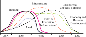
The outline above provides a general overview of some of the different mechanisms implemented by BRR in its approach to the coordination of the rehabilitation and reconstruction of Aceh and Nias. In summary, there were four important shifts within BRR’s coordination of the recovery programme, as follows:
Sri Lanka
Dr M. Mazahim Hanifa
Livelihood Economic Recovery
Officer
Reconstruction and Development
Agency (RADA)
Response structure
Sri Lanka faces occasional natural disasters such as floods, landslides and droughts that claim lives and cause loss of property. In these situations, relief and recovery operations are organized through the National Disaster Management Centre of the Ministry of Social Services, but are now handled by the Ministry of Disaster Management. Government agents and District Secretaries play the key role in coordinating activities within the affected areas.
The sheer scale of the tsunami disaster, however, created additional challenges and highlighted the gaps that existed in Sri Lanka’s institutional mechanisms to cope with a natural disaster of such magnitude.
The Government of Sri Lanka felt that relief work needed to be more systematically organized. Three separate task forces were set up to carry out rescue and relief operations and start the reconstruction and rehabilitation process:
TAFREN was created as the primary institutional mechanism in recovery and reconstruction to coordinate, facilitate and assist implementing organizations, to coordinate donor assistance and fund raising activities, to expedite the procurement process, and to enable implementing agencies through capacity building. The work of TAFREN was organized based on four thematic areas:
Following an evaluation of the progress made in tsunami recovery during the first 12 months, the Government of Sri Lanka decided that improvements needed to be made in the delivery, progress and quality of the interventions provided by a wide range of service providers, ranging from national government departments, to international and local development agencies. To this effect, the Reconstruction and Development Agency (RADA) was established by a directive of His Excellency the President by merging TAFREN and THRU to carry out reconstruction and development work in districts affected by human made or natural disasters cost effectively and expeditiously. The major functions of the Reconstruction and Development Agency are:
The Livelihood Unit of RADA was developed with assistance of the World Bank, United Nations Development Programme (UNDP) and the International Labour Organization (ILO) the Income Recovery programme (IRP). This is also known as the “Back to Work” component of a wider strategy of the Government to “Build Back Better”. The IRP is concerned with the recovery of the local economies devastated by the tsunami by fast-tracking, monitoring and coordinating livelihood recovery activities and receives technical advisory support from the International Labour Organization (ILO) through the Income Recovery Technical Assistance Programme (IRTAP).
The RADA livelihood unit has conceptualized the income recovery assistance under three broad types of instruments:
A decentralized structure was established to strengthen Districts and Divisions in the livelihood coordination in 10 tsunami affected districts. The programme thus provides a flexible decentralized system of management and coordination for a comprehensive and transparent response to local livelihood needs.
At National level, the livelihood unit of RADA is headed by a Director and supported by a Programme Officer, Economic Recovery Officer, Social Protection Officer and Infrastructure Development Officer. The unit is supported by Income Recovery Technical Assistance Programme of ILO. The livelihood unit is liaising with line ministries, donor agencies, INGOs, NGOs, the private sector, training institutions, micro-finance institutions and key sectoral institutions related to fisheries, agriculture, tourism and small and medium enterprise development. Information is being collected from a wide variety of sources and is being disseminated throughout the country and to beneficiaries.
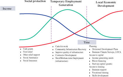
Figure 1: The three instruments of livelihoods recovery
At District level, livelihood units have been established in ten tsunami affected districts. Each unit is headed by a District Livelihood Coordinator and supported by District Economic Recovery Officer and a MIS officer. The unit is located in the district secretariat and work under the direct supervision of the District Secretary. The main function of these livelihood teams is:
At Divisional level, the livelihood unit has appointed divisional livelihood officers to 43 tsunami affected divisions of the ten districts. Livelihood officers are attached to the divisional secretaries and technically guided by the district livelihood coordinator.
Lessons learned
The sheer numbers of actors and the size of the reconstruction needs have made coordination a huge challenge. A lot of progress has been made in establishing effective coordination mechanisms. Government Officials, staff from INGOs, NGOs, UN agencies and donor agencies now meet on a regular basis in monthly livelihood coordination meetings. Similar meetings are organized in a number of divisions as well. Success of the meetings depends on the ownership and leadership taken by the District Secretary. Significant progress has been made in strengthening the district and divisional capacity for coordination efforts, and continued efforts need to build further on existing capacity building activities.
The efficiency of the coordination has suffered from the lack of easily available comprehensive, accurate and up to date information about the demand for and supply of livelihoods recovery activities at district and divisional level. Information has been collected in a multitude of different formats and focussing on different themes and geographical levels. Local level decision-makers and implementing agencies alike have been struggling to have an overview of the recovery activities. This situation has much improved during recent months. Divisional Livelihoods Development Plans (DLDPs) have been completed and endorsed by the Divisional Secretaries for 35 Tsunami affected Divisions. This is a comprehensive, participatory and holistic livelihood planning exercise through which gaps in the divisional livelihoods recovery process are identified. At the same time, a district level livelihood supply database has been put in place, and monthly progress is being received from service providers and implementing agencies.
Communication is essential, especially with the communities. Too many beneficiaries eligible for post-tsunami support have had difficulties in accessing correct and complete information about available opportunities and programmes. Community-based organizations need to be strengthened and full use needs to be made of the local media.
Sri Lanka
Shantha Emitiyagoda
Deputy
Director Extension, Department of Agriculture
Peradeniya, Sri Lanka
With the receipt of assistance on humanitarian grounds from people and organizations the world over, it was necessary for the Government of Sri Lanka to assess the value of damage caused to the crop sector. A detailed census study (Emitiyagoda et al. 2005) estimated damages and financial losses to the agricultural crop sector, (Figure 1) was about 4 466 ha of which paddy was the worst affected. The total number of farmers affected was 8 366. The total financial loss incurred in the crop sector damage was estimated to be around USD 5 million.
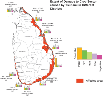
Figure 1: Crop damage caused by the tsunami
In some areas, the salinity level of soils increased by 4-25 times compared to that of unaffected areas (Kudagamage et al. 2006). However, soil salinity levels in most areas were not as high as expected, except some areas where the soils were heavy and drainage was poor. Apart from increased soil salinity in crop lands, domestic wells and agro-wells were also polluted with sea water and other hazardous liquids and soil material (Kudagamage et al. 2006).
A number of Government Organizations (GOs), International Organizations (IOs), Non-Governmental Organizations (NGOs), International Non-Governmental Organizations (INGOs) and Private Sector (PS) were involved in the relief and reconstruction activities in the affected agricultural areas.
The study conducted to assess the impact of the tsunami on the agricultural sector carried out by the Department of Agriculture of Sri Lanka (Emitiyagoda et al. 2006) was supported technically and financially by the project on Regional Information Management and Coordination on Strategies for early recovery of Agriculture in Coastal Region. The information was collected from sample surveys using a structured questionnaire, and from a check list from the key informants and supplemented with information collected through Participatory Rural Appraisal tools.
The results indicate that agricultural output has improved and that productivity in the paddy sector is approximately 15 percent higher than before the tsunami. This may be due to supply of quality seed paddy and recommended amount of fertilizers together with advices provided by the relief agencies.
However, per family monthly total income incomes before and after tsunami at the current price indicate a 13 percent reduction. The majority of the affected farmers reported reduced annual income (nearly 30 percent reduction) from agriculture than what they earned before tsunami. This may be due to an increase in off farm income per family after the tsunami and a reduction in the area of land reduced cultivated in spite of productivity improvements in paddy farming. Reasons for reduced extent of cultivated land include shortages of irrigation water, especially during the dry season, labour shortages, non replacement of machinery, insufficient or no reconstruction of damaged infrastructure and soil salinity. Reduced income from farming of paddy, other field crops, fruits and livestock sectors was also reported. Only the affected farmers growing vegetables have reported slightly higher incomes compared to pre tsunami levels. This suggests that overall livelihoods of the affected farmers has not come back to normal after one and half years and the objective of “building back better” is yet to be achieved. Although farmers may still be struggling, some agro-industries such as coconut toddy tapping, preparation of retail food items such as meal packets and sweets, cinnamon processing, and gram processing have achieved a satisfactory level.
More than 90 percent of the affected farmers have received relief. NGOs and INGOs were prominent in rural districts providing relief while GOs were prominent in cosmopolitan districts. The Emergency and Rehabilitation Project of the Food and Agriculture Organization (FAO) is reported as the major relief provider in the agricultural sector. Small farm implements such as mammoties were replaced (100 percent) adequately. Supply of seed and planting material to affected farmers was satisfactory (93 percent).
Table 1: Average annual income from the different farming sectors in USD
|
Farming sector |
Before tsunami |
After tsunami |
% Difference |
| Paddy | 1 338 | 959 |
-28 |
|
Other field crops |
1 120 | 891 |
-20 |
| Vegetable | 435 | 456 |
+5 |
| Fruits | 239 | 179 |
-25 |
| Livestock | 346 | 238 |
-31 |
There were reports of some shortcomings in the relief granted to agricultural sector. Though the damages to water pumps and sprayers were reported by 30 percent of the farmers, only 14 percent of the farmers reported that they have been replaced. Crop recovery from the extents cultivated by affected farmers was reported as unsatisfactory in some districts due to drought and labour shortages.
Machinery such as 2- and 4-wheel tractors were damaged by the tsunami but none were replaced. There is a gap in replacing livestock such as cattle, buffalo and poultry. Milk and yoghurt industries damaged by the tsunami were also reported as not reconstructed. The rice processing industry, the main agricultural activity in the affected areas, was affected by tsunami, and the study revealed that these industries have not fully recovered yet. Recovery of infrastructure facilities such as agricultural roads, culverts, irrigation canals, stores and Agrarian Service Centers are reported to be not satisfactory.
The study also revealed that most agencies were involved in serving a majority of affected farmers with comparatively low investment needs, ignoring a small number of affected farmers and infrastructure facilities, which need comparatively large investments. Overall, the livelihoods of the affected farmers have not recovered.
Tsunami emergency aid
The tsunami was the worst disaster ever experienced in the history of Sri Lanka, and agencies were simply not prepared at all to handle such a situation. Damage to different sectors was so extensive and sudden that it was impossible for a single agency to handle the emergency aid.
The newly established Disaster Management Centre, under the purview of Ministry of National Disaster and Human Rights, is responsible for overall coordination and handling of disaster and emergency situations in Sri Lanka. District secretariats and divisional secretariats under the Ministry of Home Affairs are responsible for handling emergency aid for the affected people. Together with other agencies (GOs, NGOs, INGOs, IOs, and PS) they took immediate action to set up refugee camps, provide supplies of cooked food, and provide other urgent humanitarian aid. In response to the situation, the Reconstruction and Development Agency (RADA) was set up as a coordination body directly placed under the HE the President of Sri Lanka.
The Ministry of Agriculture, Lands, Livestock and Irrigation (MALLI) is the agency responsible for activities related to tsunami emergency aid in the agricultural sector. The Department of Agriculture coming under the MALLI is responsible for implementation of activities related to emergency aid, being the organization with most number of technically qualified staff, spread all over the country.
The MALLI had four sectors namely Agriculture, Livestock, Lands and Irrigation. The sector is extensive and MALLI was not prepared to handle the huge disaster, even though the damage was less than in the fisheries sector.
Achievements
The Ministry established a 24 hour operational emergency unit on 27th Dec. 2006 to address to the needs of the affected farmers. With the receipt of assistance on humanitarian grounds from many people and organizations, it became necessary for the Government to assess the value of damage caused to the crop sector. Information collection was done in an organized manner through a team comprising national, divisional and village level officers. Senior scientists were deployed to different areas to train and assist the field level officers on different subjects such as rice, other field crops, vegetables and soils, to collect information on damages on the sector.
Other Departments under MALLI such as the Department of Animal Production and Health, Department of Irrigation, Land Commissioners Department also collected information on damage in their sectors. The Ministry and Departments collected relief items from donors and distributed them to affected farmers through local administrative organizations. The Ministry also established and maintained a database that was updated with the information received from the respective Departments.
The MALLI also participated in inter-ministerial committees organized by the Food and Agriculture Organization (FAO). Relief agricultural items such as seeds, small implements such as mammoties and knives received from donors were distributed to affected farmers through DOA. A separate team of scientists was mobilized to affected areas to study the status of soil salinity and to advise on reclamation measures. All of them served voluntarily.
Shortcomings
It was difficult to collect information immediately as most of the affected farmers were displaced and there were too few village level extension staff in the field. Information regarding export crops, small home garden and livestock damage was not reported accurately or in a timely manner. As information was collected through a census study, damage to infrastructure such as markets, roads, rice mills, supporting services, agro industries were not reported.
Lessons learned
There was duplication of services provided to the agricultural sector due to the absence of an effective coordination mechanism. In the data collection, emphasis was given to crop sector damage. Thus, information on losses and damage to livestock, export crops, small home gardens etc. were not collected properly.
There was no inventory of damages to infrastructure in the first study. This may be the reason for the donors not paying adequate attention for reconstruction of the damaged infrastructures. Parallel data collection procedures should be adopted in an initial census study.
The lowest priority was shown for agriculture by local administration offices that undertook the provision of relief and rehabilitation work for the agricultural sector. Efficient coordination mechanisms should be kept in place at national level with different sectors as well as between the different sectors.
There was difficulty in collecting relevant information soon after the tsunami as some farmers were displaced and were in a refugee camp at the time of data collection. Enumerators had to go to farms and refugee camps to collect information. Farmers need at least one month to resettle and to recover from the shock.
The weaknesses in the information coordination mechanism with GOs, NGOs and INGOs at district and national levels led to duplication and averting of relief activities in certain areas.
Recommendations
The Government of Sri Lanka has established the Disaster Management Centre (DMC) and the Reconstruction and Development Agency (RADA) to coordinate the tsunami and emergency information, relief and rehabilitation activities at the national level. RADA is partly responsible for establishment of coordination mechanisms in different sectors such as agriculture, fisheries and forestry. It is recommended to establish an emergency coordination unit in the respective Ministries for efficient coordination at the sector level.
Establishment of a situational database for the sector at a central point with frequent updating facilities with easy accessibility to stakeholders is much needed in the agriculture sector and could be made available to others through a website. Rehabilitation agencies could use this database to avoid duplication of services and omission of assistance to certain affected people being served.
Finally, the capacity of officers at all levels in GOs, NGOs, and PS for disaster management needs to be improved.
References
Anonymous, 2005. ADB, JBIC and World Bank Reports.
Central Bank of Sri Lanka. (2004). Annual Report, Central Bank of Sri Lanka.
Mark B. and J. Rickman. (2005). Sri Lanka Trip Report Feb. 7-12, 2005, International Rice Research Institute, Philippines.
Emitiyagoda G.A.M.S., A.R.M. Maharouf and I.S.M. Hameldeen, 2005, An assessment of damaged caused to the crop sector in the tsunami affected areas in Sri Lanka; Annals of Sri Lanka; Department of Agriculture. 7:347-352.
Emitiyagoda G.A.M.S., R.M. Herath and R.S. Abesekara 2006 unpublished study report on assessment of the impact tsunami relief granted to agriculture sector and to affected farmers in Sri Lanka.
Kudagamage C., Punayawadane B.V.R. and Emitiyagoda S., 2006 Effects on Tsunami on Agriculture sector in National context; Proceeding of the workshop to develop strategies for advancement of agriculture sector in tsunami affected areas of Sri Lanka; FAO 9-1.
2 SIM Centre presentation “Using Spatial Information to Support Emergency Relief & Recovery Activities: The experience in Aceh”. presented in the workshop on “The role of information and coordination for early recovery of agriculture, fisheries and forestry rehabilitation of tsunami affected areas of Aceh, Indonesia”, Banda Aceh, 16-17 October 2006.
3 Note that officially a further
166 234 “missing or unaccounted for” will be presumed dead after a year.
4 Source: USAID. (2005). Indian Ocean
Earthquake and Tsunamis: Fact Sheet #38, Fiscal Year (FY) 2005.
Washington: United States
Agency for International Development. 6 May 2005.
5 Report of the study on tsunami rehabilitation works and coordination mechanism in agriculture, fisheries and forestry sectors (2006).
6 This was one of the findings from the workshops (ibid.), though there was also a natural reduction of INGO presence as the acute emergency gave way to recovery programme.
7 BRR - Agriculture sector presentation in “the role of information and coordination for earlier recovery of tsunami affected area of Aceh” on 16-17 October 2006.
8 The GOI’s Master Plan was prepared by BAPPENAS in consultation with local, national and international stakeholders. It contains broad (Book 1) and detailed (Books 2-11) descriptions of the recovery plan for Aceh and Nias, and was formally adopted by the GOI in April 2005.
![]()
![]()
![]()