![]()
![]()
![]()
Sri Lanka
P.A.G.S. Nandakumara
Assistant Conservator of Forests
Forest
Department, Sri Lanka
The pre-tsunami status of coastal trees and forest resources
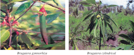
Sri Lanka’s coastal habitats include estuaries, lagoons, mangroves, sea grass beds, salt marshes, coral reefs and large extents of beaches. Of these habitats, mangroves are tree dominated ecosystems which comprise a rich component of biodiversity. According to the forest cover survey carried out by the Forest Department in 1999, the mangrove forest area in the country was estimated at around 9 530 ha with the largest extents in Puttalam, Batticaloa, Trincomalee and Mannar districts.
The most extensive mangrove areas at present occur in Puttalam-Kalpitiya area in estuaries. Trees in mangrove ecosystems comprise both true mangrove species and mangrove associates. Fourteen species of true mangroves and 12 species of mangrove associates have been recorded in Sri Lanka. (Sri Lanka’s Mangroves, CCD).
Coastal habitats are under enormous pressure because many are small and especially vulnerable to degradation. The mangrove ecosystems in Sri Lanka are not extensive as they occur as a narrow inter-tidal belt that extends less than 1 km landward from the mean low water tidal level. Sri Lanka’s low tide, which rarely exceeds 75 cm, is the main cause for this limited distribution. Most of the mangrove habitats are restricted to narrow belts along the lower reaches of rivers and narrow edges of lagoons and estuaries, hence, there are no large mangrove forests in the country. The main mangrove habitats can be seen along the west, North-east and East Coasts, but they are most extensive in the Puttalam district comprising about 2 300 ha.
Mangrove forests are important as nursery grounds for marine organisms and also provide many resources for human use such as poles, roof thatch, fodder for cattle, fuel wood, ripe fruits and leaves used as food and raw material for cottage industries.
The mangroves forests that exist have become severely reduced by overuse, abuse and conversion to other uses. The most common cause for destructions of mangrove forests is conversion to prawn farms. These prawn farms have been established in cleared ecologically sensitive mangrove areas in the north-west exerting tremendous pressure on mangroves and degrading associate lagoons and estuaries. As a result, the naturally fragmented mangrove forests have been further reduced and degraded by clearing for prawn farms, human settlements, and by water pollution and siltation. The extraction of poles and fuel wood for domestic use and twigs for brush-pile fishing from the mangrove vegetation is also carried out beyond sustainable levels.
Other coastal forest areas include Casuarina equisityfolia plantations established by the Forest Department. The total extent of Casuarina plantations established in the coastal areas of Sri Lanka is around 3 400 ha. The largest extents are recorded in Trincomalee District (Bandaratillake, 1992). These Casuarinas plantations in coastal areas have been established since the early 1900s and provide a protective green belt along the coastline.
Other trees in coastal areas include trees grown in home gardens and land along the coastal belt. These include: Coconut palms (Cocos nucifera), Palmyra (Borassus flabellifer), Eucalypts (Eucalyptus spp.), Neem (Azadirachta indica), Tulip tree (Thespesia populnea), Mango (Mangifera indica), Tamarind (Tamarindus indicus), Teak (Tectona grandis), Satin (Chloroxylon swietenia), Country almond (Terminelia cattappa), Banyan (Ficus bengalensis), Cassia (Cassia spp.), Guava (Psidinum guajava), Oleander (Nerium oleander), Temple tree (Plumeria obtusa), Indian willow (Polyalthiya longifolia), Jak (Artocarpus heterophyllus), Cashew and Pandanus spp. (UNEP/MENR, 2005).
Forest related impacts of tsunami
After the tsunami catastrophe of 26 December 2004, the Ministry of Environment and Natural Resources (MENR) took steps to carry out rapid environmental assessments in the tsunami affected areas in close cooperation with the Central Environmental Authority (CEA) and with the assistance and support of the United Nations Environment Programme (UNEP). Two post-tsunami environmental assessments were carried out in 2005 by the MENR to assess the impact on coastal ecosystems. In addition, IUCN – The World Conservation Union, carried out three studies in 2005 on assessment of tsunami impacts on coastal ecosystems in Ampara and Batticaloa districts and some selected Protected Areas in Southern Sri Lanka.
The Department of Wildlife Conservation (DWLC) in Sri Lanka carried out a study in 2005 to assess the damage caused by the tsunami to the Protected Areas of the DWLC.
The information shows that coastal forests (mangroves and casuarinas forest plantations) in Sri Lanka provide significant protection against tsunami waves and provide remarkable security to people who live in the coastal areas. Some of these mangrove and Casuarina plantations were damaged by the tsunami wave. Although the rehabilitation effort was essential to repair damage, it was not enough. We have to think further and take this opportunity to make better livelihoods for coastal dwellers by ensuring a secure environment and enhancing productivity through forestry. To achieve this goal, information gathering and management and effective coordination mechanisms with all stakeholders are essential requirements.
Information required for protection
Maps are useful for identification of location, but only if sites are properly surveyed and boundaries are marked. All vulnerable forest ecosystems should be given the status of conservation forest. The mangrove forests in the area should be included on a national priority list. All coastal forest vegetation are under the administration of the Forest Conservation Department the Coast Conservation Department or the Wildlife Conservation Department. Apart from that, privately owned forest ecosystems also need to be taken into account. Information required for effective management includes the following:
Table 1: Average impact of tsunami on Forestry and related other vegetations
|
Type of Vegetation |
Impact to Vegetatio |
Protection to Inner Areas |
Degree of Impact to Vegetation |
|
| 1. | Mangroves |
|
Positive effect as physical barriers for protection of inland areas and prevented erosion. |
High – Moderate |
| 2. | Casuarina |
|
Favourable impact on sand due fixations and provide a moderate protections |
Moderate |
| 3. | Coconut |
|
Reduced beach erosion |
Low |
|
4. |
Palmyra |
|
No significant protection |
High |
| 5. | Homegardens |
|
Little protections |
Low |
|
6. |
Scrub forest |
|
– | Moderate |
Information required for production
For production and sustainable use of coastal vegetation, well-disciplined information is required. This includes:
Coordination for protection
The main government agencies involved in management of coastal areas are the Coast Conservation Department, the Forest Department and the Wildlife Conservation Department. They are the implementing agencies for the Coast Conservation Act, Forest Ordinance and Fauna and Flora Protection Act respectively. The Coast Conservation Department is not, at present, able to give sufficient attention to conservation of coastal forests. Their focus is on the “hard infrastructure” of the coast. The Department of Wildlife focuses on wildlife living in sanctuaries and coastal areas. Therefore, the Forest Department has a vital role to play to conserve the mangroves and other coastal forests and coordinating with other authorities.
The other important constraint on better management is the privately owned mangrove forest land situated in the coastal area. It is not under the purview of the Forest Department. It is essential to coordinate private forest owners and bring them under the same management system.
Coordination between the Forest Department and the communities can more effectively protect the coastal forest land through partnerships between the foresters and the communities. Efficient and effective protection can be achieved with ecological and economic benefit for the society. The Forest Department and communities should work towards a plan which offers employment opportunities for low income and high forest-dependant groups. The Forest Department has to conduct awareness campaigns especially in highly vulnerable areas using their extension officers. Extension officers can join with several environmental NGOs that are active in this area. NGO participation in protection of these areas can be important as they can serve as local coordinators. Their knowledge about the local situation and the institutional activities and their ability to help in coordinating programmes and extension, conducting workshops, seminars and training programmes will play a significant role in mangrove and coastal forest management.
In addition, national level coordination could be achieved through collaboration with the:
District level coordination can be improved by making better use of the District Coordinating Committees and District Agriculture Committees. Local level coordination can be achieved at the Divisional Secretariat level and field level coordination through local communities, religious heads, grama niladari, NGOs, community-based organizations and local other officials.
Coordination for production
The coastal forest ecosystems have many potential benefits for fisheries, agriculture, tourism and forest-based industries. The mangrove forest system provides habitats and breeding grounds for crustaceans and fish. Management of mangrove forest for aquaculture can increase fish productivity. The coastal forest acts as a wind barrier and can increase productivity of agricultural land and generally improves the local living environment. The mangrove forest system represents a fascinating and aesthetic treasure due to its diversity and complexity in terms of greenness, natural beauty and perennial serenity. These qualities are certain to attract tourists. Management of coastal forest for eco-tourism provides economical benefits to local communities. This forest ecosystem is valuable ground for community-based industries such as coir fibre, apiculture, vinegar production and fruit processing.
The coastal forest ecosystem can be effectively managed with community participation. Collaboration and coordination between all relevant sectors are essential for effective management. It is important to set up a multidisciplinary coordination committee comprising state organization, NGOs, community-based organizations and other site-specific stakeholders. This would enhance the productivity within an integrated, collaborative, framework and ensure that forests are conserved in a manner beneficial to the local communities living around them. In addition to community-based multidisciplinary coordination, national, district and regional level coordination among the relevant stakeholders is essential. Sustainable and effective coordination among various stakeholders makes better livelihoods in the tsunami affected areas in Sri Lanka.
References
Burrough P.A. (1986) Principles of Geographical Information Systems for Land Resources Assessment. Monographs on Soil and Resources Survey, Oxford: Clarendon Press, 193 pp.
Cicin-Sain, Biliana and RW Knecht (1998) Integrated Coastal and Ocean Management: Concepts Practices. Washington, WA. Island Press.
Clark, J.R. (1997) Coastal Zone Management for the New Century. Ocean & Coastal Management. 37(2): 191-216.
Clark, J.R. (1996) Coastal Zone Management Handbook. Florida, Fl. Lewis Publishers.
DOE (Department of Environment) (1987) Handling Geographic Information. HSMO, London.
FAO (Food and Agriculture Organization of the United Nations) (1996) Agro-ecological zoning -Guidelines. FAO Soils Bulletin 73. Rome, Italy.
Harris, T. and D. Weiner (1998a) Community-Integrated GIS for Land Reform in Mpumalanga Province, South Africa. http://www.ncgia.ucsb.edu/varenius/ppgis/papers/harris.html
____ .
(1998b) Empowerment, Marginalization and “Community-integrated” GIS. Cartography
and Geographic Information Systems 25(2): 67-76.
Humphreys R.G. (1989) “Marine Information System” the Hydrographic Journal No. 54 Oct. 1989.
Ignas Dummer. (2004) Information and Knowledge Based System for Land Suitability Analysis in Cambodia. In: Proceedings on Land Resource Assessment Forum for Cambodia. pp. 59-74; September 14-17, 2004, CARDI, Phnom Penh, Cambodia.
Johnson, B. (1997) The Use of Geographic Information Systems (GIS) by First Nations.
Joshi M.D. and R. Shivakumar (2000) “Some aspects of Accuracy in GIS” GIS@Development Vol. 2 Issue 2.
Krola Natural Resources Management Committee (2002) Community Land Use Planning: A case study from Krola Village, Ratanakiri, Cambodia. Non-Timber Forest Products (NTFP) Project.
Kurt Fedra & Endrico Fedli. “GIS technology and special analysis in Coastal Zone Management” by EEZ Technology Edition 3.
Kyem, P. (1998) Promoting Local Community Participation in Forest Management through the Application of a Geographic Information System: a PPGIS Experience from Southern Ghana.
Larijani, L. (1998) GPS for Everyone. American Interface Corp, New York.
Parker, H.D. (1988) The unique qualities of geographic information system: a commentary. Photogrammetric Engineering and Remote Sensing, 54: 1547-1549.
Pickles, J., ed. (1995) Ground Truth: The Social Implications of Geographic Information Systems. Guilford Press, New York.
Poole, P. (1995a) Guide to the Technology. Cultural Survival Quarterly 18(4): 16-18.
Robin K.H. Falconer (1990) “Experience with Geographic Information System (GIS) in the marine world”. Hydrographic Journal No. 58 Oct. 1990.
Rock F, ed. (2001) Participatory Land Use Planning (PLUP) in Rural Cambodia: Manual for government staff and development workers. Ministry of Land Management, Urban Planning and Construction.
Sirait, M. et al. (1999) Mapping Customary Land in East Kalimantan, Indonesia: A Tool for Forest Management (9 February 1999). http://envgov.ewc.hawaii.edu/env/working.papers/jfox/ kali.html
Smith, T.R., Menon, S., Starr, J.L., and Estes, J.E. (1987) Requirements and principles for the implementation and construction of large-scale geographic information systems. International Journal of Geographic Information Systems, 1:13-31.
Tariful Islam and Harun-Ar-Rashid. 2004. An Integrated Approach of Using GIS, Farmer’s Knowledge and Digitize Database to Maximize Crop Yields. In: Proceedings on Land Resource Assessment Forum for Cambodia. pp. 98-109; September 14-17, 2004, CARDI, Phnom Penh, Cambodia.
DOF-FAO Andaman Forum home page
Thailand
Mr Simon Wilkinson, Communications Manager
Network of
Aquaculture Centres in Asia
and the Pacific
and
Ms Waraporn Prompoj, Chief International Cooperation
Group
Department of Fisheries, Thailand
The need for better information
There has been a serious shortage of reliable and timely information on which to base post-tsunami rehabilitation planning and decision-making to assist affected communities. This has lead to duplication of effort and waste of resources.
Social conflicts due to inequity (real or perceived) in distribution of assistance.
While the need for reliable information has been widely recognized there has been no established mechanism for sharing information on rehabilitation activities.
First stepsIn Thailand more than 95 percent of damage to natural resource sectors was in fisheries. A Joint Sub-committee on Post-tsunami Rehabilitation was established in January 2005. DOF and FAO played a leading role in ‘Task Force No. 3’ on land subsidence, saline intrusions and livelihoods. The committee met three times but activities were limited and sub-committee was not continued. Agency and project profiles were stored in the Development Assistance Database (DAD) managed by TICA (MoFA). Smaller organizations and local activities not captured.
Impact on fisheries
There are growing concerns over the status of coastal fisheries, specifically, “Had fish stocks been impacted by the tsunami”? There were increasing reports of duplication of effort and lack of coordination in distribution of fishing inputs, specifically an anticipated oversupply of fishing boats; a risk of increasing fishing capacity and pressure on fisheries resources.
Potential long-term impact on fisher livelihoods; and a growing need for reliable information on the distribution of fishing inputs to facilitate coordination and informed decision-making.
Coordination meeting
DOF and FAO convened a donor coordination meeting to discuss progress in rehabilitation of the fisheries sector. 60 participants attended from 26 organizations including NGOs.
Lack of information on ‘who is doinog what and where’ identified as the main barrier to coordination of effort. It was concluded that reliable information would aid planning and allow resources to be allocated more efficiently.
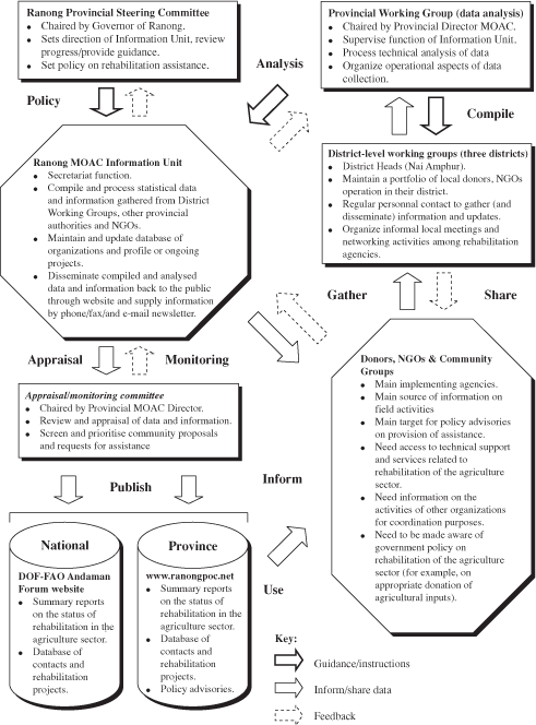
Information unit
Major outcome of the coordination meeting was an agreement to establish a rehabilitation information unit in DOF with the aim to provide:
Need for local information
Initial data collection by the Information Unit was primarily via phone interview. Proved effective for gathering information from larger organizations providing rehabilitation assistance. However, small organizations are hard to find. Later it became apparent that information collection mechanisms and skills had to be improved at provincial and district level as well. Development of reliable national-level information depends on obtaining reliable local information. Local coordination between government and NGOs is essential as NGOs are major supplier of fishing inputs.
Strengthening local capacity
Provincial rehabilitation coordination meetings were organized by the Phang Nga and Ranong MOAC and FAO. This was the first time that provincial government and NGOs had been brought together to facilitate coordination. In Phang Nga: 65 participants from 36 organizations including 12 NGOs. In Ranong: 50 participants from 26 organizations including 14 NGOs. The meetings addressed broader agriculture sector, inclusive of fisheries, forestry and livestock.
Strengthening local capacity
It was agreed to establish provincial rehabilitation information units for agriculture within MOAC with provincial units to be linked to the DOF unit. Two of the lead actors, Dr Waraporn (DOF), Khun Aekachai (MOAC Ranong) and Khun Suksa (MOAC Phang Nga) attended the final FAO workshop in Bangkok 30 October - 1 November 2006.
Technical assistance
FAO provided technical support in planning the information units, including:
Capacity building
FAO provided human capacity building for government personnel in the form of:
Links between units
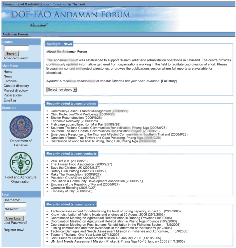
Provincial data is shared via the DOF-FAO Andaman Forum website. Provinces also undertake their own dissemination activities within local jurisdiction (phone, fax, e-mail etc.). Ranong also publishes via the Ranong Operations Centre website www.ranongpoc.net.
Use of standardised rehabilitation indicators ensures that provincial data can be aggregated and exchanged.
DOF-FAO Andaman Forum
The scope of the DOF-FAO Andaman Forum website has been expanded to support information on the agriculture, livestock and forestry sectors. The Forum strengthens the role of the website as a ‘one stop shop’ or clearing house for post-tsunami rehabilitation information and adds value to provincial information. Feedback indicates that it is convenient for end users.
Building capacity
These activities have been undertaken to support post-tsunami rehabilitation. However, the capacity and system that has been established can be used to support other development work in the future. The focus is on building capacity that will remain useful for the long term. DOF has fully assumed management of the Information Unit using its own staff and financial resources, ensuring sustainability.
Organogram
![]()
![]()
![]()