![]()
![]()
![]()
The majority of the rural population in Eastern Province of Zambia are small scale farmers, growing crops for home consumption and for sale. The purchasing power of these farmers is low. Nutritional problems of inadequate energy and protein consumption prevail in the whole country, although these problems are mainly seasonal and are specific to certain groups of the population. Fish consumption accounts for 50% of the animal protein intake, but the per caput consumption is declining. Important sources of fish are the main rivers and lakes located in other Provinces. Most of these fish are sold in a dried form in Eastern Province. The demand of fresh fish is high and is not met by the supply.
In order to determine the potential importance of the reservoir fishery in Eastern Province of Zambia an inventory of the reservoirs was made. The. inventory was mainly based on information from the Department of Water Affairs (DoWa), and gives year of construction, location, riversystem, catchment area, size of the reservoir, and whether it has been stocked by the Department of Fisheries. The inventory has information for a total of 227 reservoirs. Information is not complete for all fields in the inventory, which explains the differences in total numbers of dams per type of information.
Table 1: Number of reservoirs by constructing agency
| Constructing agency: | Department of Water Affairs | District Council | Department of Agriculture | Community | Private | Total |
| number | 164 | 36 | 3 | 2 | 2 | 207 |
| % | 79 | 17 | 1 | 1 | 1 | 100 |
Most of the reservoirs (79%) were constructed by the Department of Water Affairs (Table 1). The majority of the reservoirs was constructed more than 30 years ago (Table 2). The main purpose for the construction of the dams was to store water in order to open new areas for settlement.
Table 2: Number of reservoirs by period of construction
| Period | before 1930 | 1930–1940 | 1940–1950 | 1950–1960 | 1960–1970 | 1970–1980 | 1980–1990 | Total |
| number | 0 | 15 | 54 | 88 | 37 | 14 | 6 | 214 |
| % | 0 | 7 | 25 | 41 | 17 | 7 | 3 | 100 |
Since the reservoirs were constructed for the purpose of storing water, the size of the reservoirs was in most cases recorded as storage capacity. Storage capacity is known for 205 of the 227 reservoirs. Fish production is more related to the surface area than to the storage capacity of a reservoir. The surface area is therefore a more useful measure of size for the planning of fisheries activities. The surface area is only known for 42 reservoirs. The following relation could be established between the surface area and the storage capacity of reservoirs smaller than 40 hectares:
X = 0.2135 * Y0.74010 (n=41, r=0.92)
X: Surface area in hectares
Y: Storage capacity in 1000 m3
Using this relation the surface area of 163 reservoirs was estimated (Table 3). Lutembwe 2, an exceptionally large reservoir (108 ha.) compared to the other reservoirs, was excluded for establishing the relation between surface area and volume, and is not included in Table 3.
Table 3: Size distribution of reservoirs
| Size (ha.) | 0–5 | 5–10 | 10–15 | 15–20 | 20–25 | 25–30 | 30–35 | 35–40 | Total |
| number | 135 | 43 | 10 | 5 | 3 | 5 | 2 | 1 | 204 |
| % | 66 | 21 | 5 | 2 | 1 | 2 | 1 | 1 | 100 |
Table 4: Characteristics of studied reservoirs
| Dam Name | Year of construction | Latitude South | Longitude East | River System | Capacity (1000 m3) | Surface area (ha) | Max.Depth (m) | Avg. depth (m) |
| Lutembwe 2 | 1989 | 13° 42' | 32° 36' | Lupande | 5063 | 108 | 20 | 5.95 |
| Chadewa | 1974 | 13° 49' | 32° 14' | Lupande | 325 | 13 | 6 | 2.50 |
| Makungwa | 1967 | 13° 46' | 32° 26' | Lutembwe | 177 | 10 | 5 | 1.77 |
| Kangombe | 1967 | 13° 39' | 32° 17' | Lupande | 94 | 6 | 3,5 | 1.57 |
| Rukuzye 2 | 1958 | 13° 21' | 32° 49' | Rukuzye | 395 | 22 | 5 | 1.80 |
The average surface area, excluding Lutembwe 2, of the reservoirs is 5.3 hectares, which brings the total surface area to 1195 hectares, and 1303 hectares including Lutembwe 2.
The total surface area of 1303 hectares assumes that all reservoirs are still in design condition. This assumption is not correct. 52 reservoirs, with a total surface area of 224 hectares, are known to have breached and no longer hold water. Because of the age of the reservoirs and the little maintenance carried out on most of them it can be assumed that more reservoirs have breached or are completely or partly silted without being reported. Reservoirs are not always constructed according to their original design and recorded size, but instead may have been constructed smaller. Dams are very seldom constructed larger than the original design. All these factors together mean that the total surface area of small water bodies in Eastern Province of Zambia is not exactly known, but is most probably less than 1000 hectares.
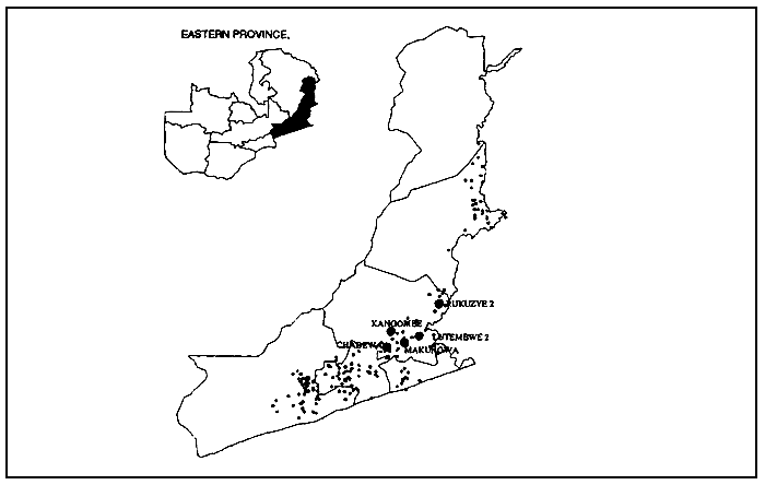
Figure 1 - Distribution of reservoirs in F.a stern Province of Zambia
The Department of Fisheries stocked some of the reservoirs with fish. Before 1970 thirteen reservoirs were stocked, between 1970 and 1980 five, and since 1980 only three. The main species stocked were Oreochromisandersonii, O. macrochir and Tilapia rendalli.
Characteristics of the reservoirs discussed in this report are given in Table 4. The shores and shallow areas of Kangombe dam are densely vegetated. There is also submersed vegetation in the near-shore areas. There are also a lot of stumps on the bottom which makes beach seining impossible. Makungwa dam has relatively little vegetation in the shallow areas. The biggest reservoir in the Province is the Lutembwe 2 (108 ha.), its shoreline is rich with vegetation and small islands which altogether supply a wide range of habitats. The shoreline is generally accessible for rod-fishing. There are few fishing obstacles for net fishing. Figure 1 shows the distribution of the reservoirs in the Province.
![]()
![]()
![]()