


The results of the WISDOM process consist of a series of geodatabases resulting from the development of the Demand, Supply and Integration modules.
Demand module results.
The geodatabase resulting from the Demand module is based on 5 arc-minute grid cells (98 592 cells of approximately 9x9 km) and contains information on the spatial distribution of woodfuel consumption for the 10 countries covered by the study in a single sub-regional map. The themes included are:
• Consumption in rural areas with population density below 2000 inhabitants / km2.
• Consumption in rural areas with population density above 2000 inhabitants / km2.
• Consumption in urban areas.
Supply module results
The geodatabases resulting from the Supply module shows the distribution of woody biomass stocking and increment at two levels of spatial resolution: national maps at full resolution and a single sub-regional map at 5 arc-minute resolution explained below:
• 10 individual national maps of biomass stocking and increment at the resolution of the original national land cover maps. The land cover maps used in this study are the spatially aggregated versions of the national Africover data sets. Their scale is approximately 1:200 000.
• One sub-regional map of biomass stocking and increment by 5 arc-minute cells of biomass stocking and increment.
Integration module results
The geodatabase resulting from the Integration module is based on 5 arc-minute grid cells and contains information on the balance, within such cells, between the consumption of woodfuels and potential sustainable supply of woody biomass available for energy uses. Two geographic representations were made:
• Sub-regional maps of demand/supply balance by 5 arc-minute cell size (98 592 units). This data set is presented at global level as well as at national level.
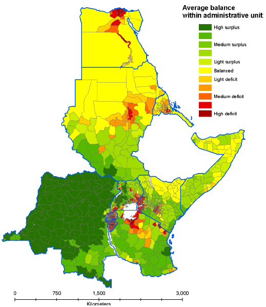
• Sub-national aggregation of cell-level balance results (1 172 sub-national administrative units). This dataset is presented at global level (with enlargement for Kenya, Uganda, Rwanda and Burundi that present relatively small sub-national units).
Figure 14: Consumption in rural areas with low population density9.
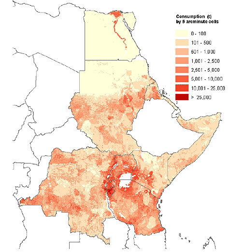
Figure 15: Consumption in rural areas with high population density (rural settlements)10
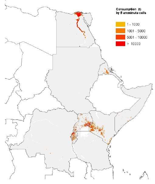
Figure 16: Consumption in urban areas
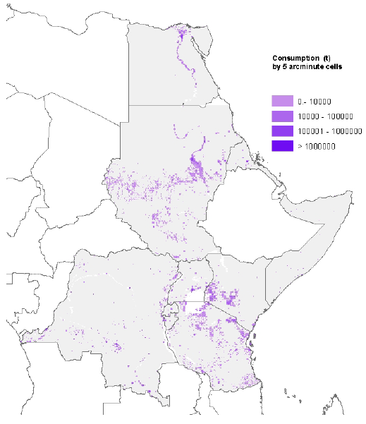
Figure 17: Woody biomass stocking
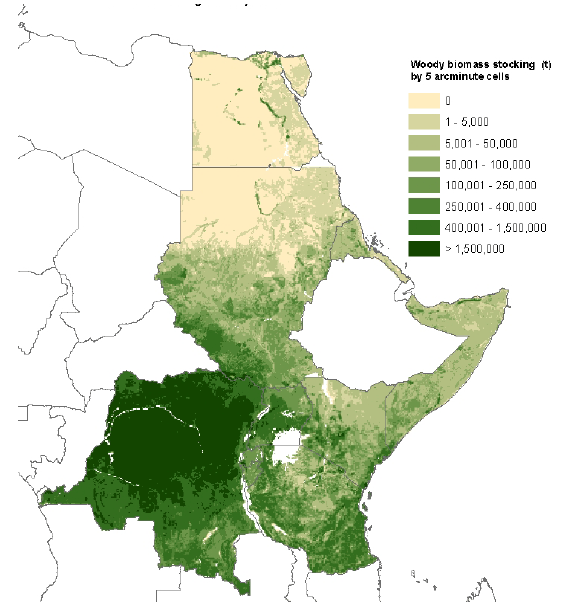
Figure 18: Estimated potential annual increment of woody biomass
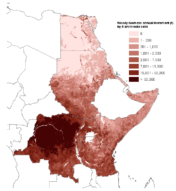
Figure 19: Burundi – Woody biomass density map
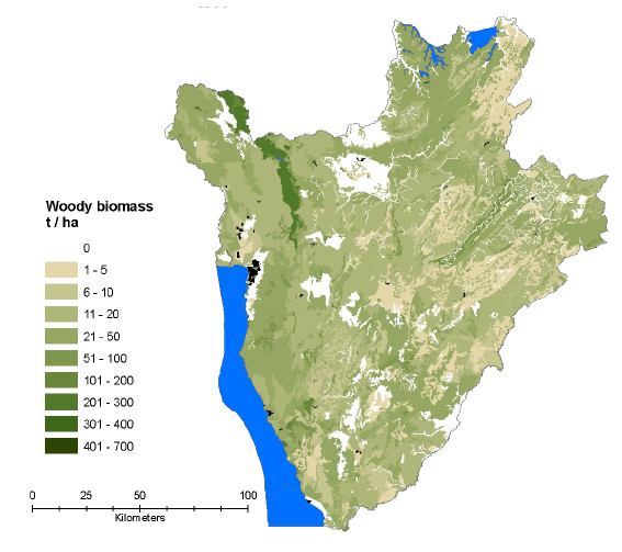
Figure 20: Democratic Republic of Congo – Woody biomass density map
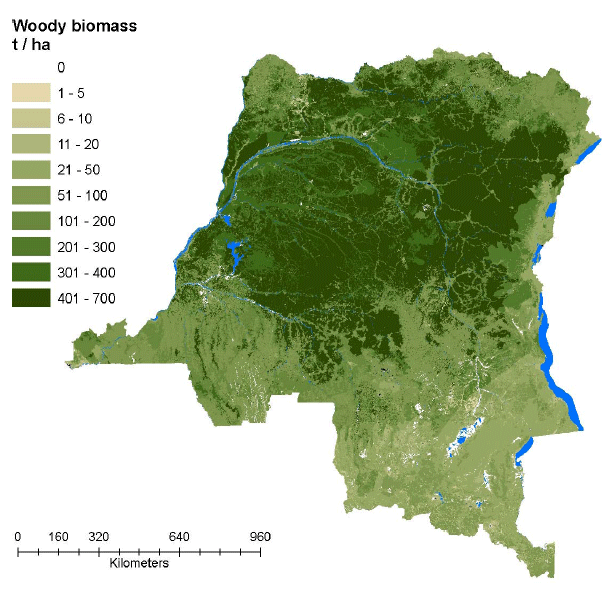
Figure 21: Egypt – Woody biomass density map
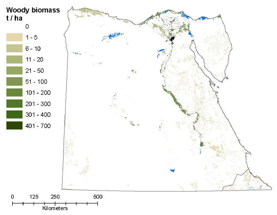
Figure 22: Eritrea – Woody biomass density map
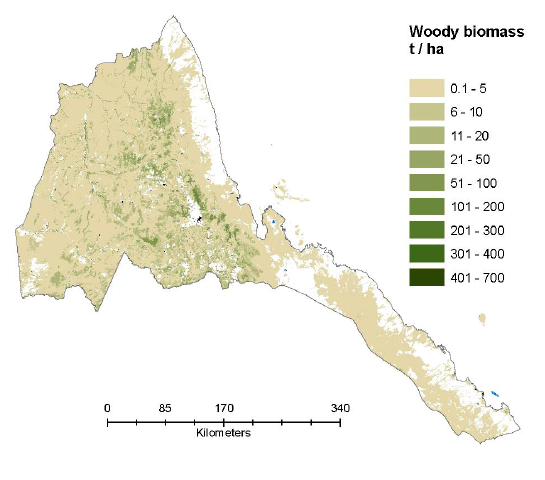
Figure 23: Kenya – Woody biomass density map

Figure 24: Rwanda – Woody biomass density map
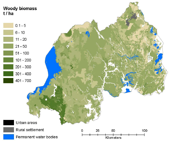
Figure 25: Somalia – Woody biomass density map
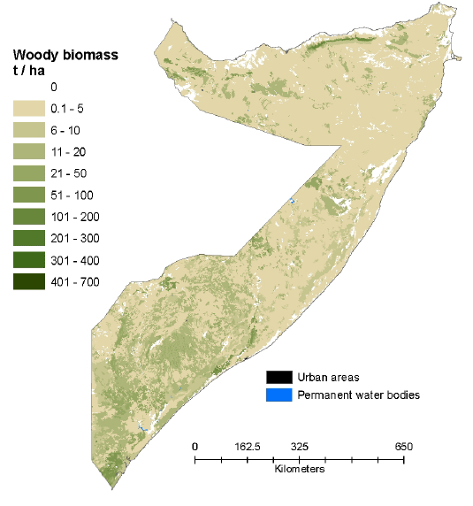
Figure 26: Sudan – Woody biomass density map
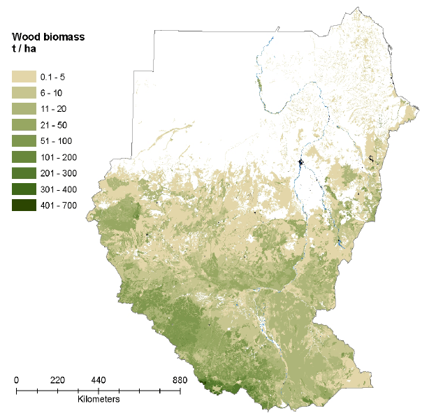
Figure 27: Tanzania – Woody biomass density map
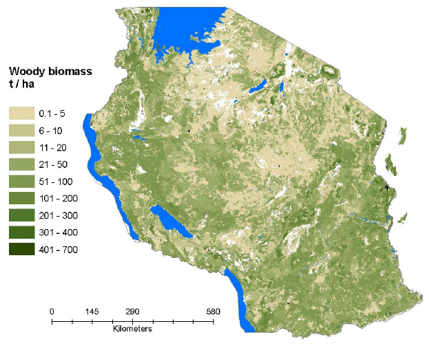
Figure 28: Uganda – Woody biomass density map
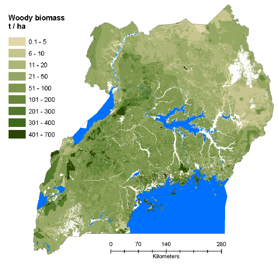
Figure 29: Regional map woodfuel supply-consumption balance categories.
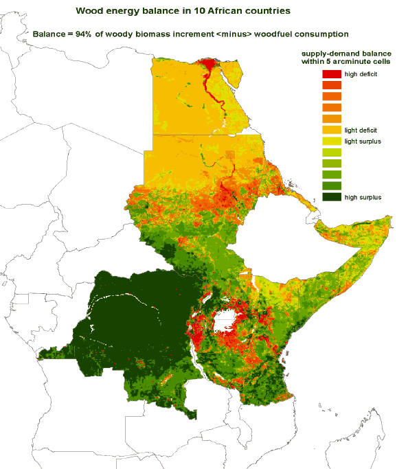
Figure 30: Democratic Republic of Congo. Map of categories of woodfuel supply-consumption balance categories.
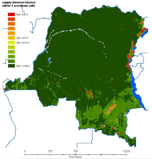
The list of the sub-national units of the Democratic Republic of Congo presenting marked deficit conditions are reported in Annex 4.
Figure 31: Egypt. Map of woodfuel supply-consumption balance categories.
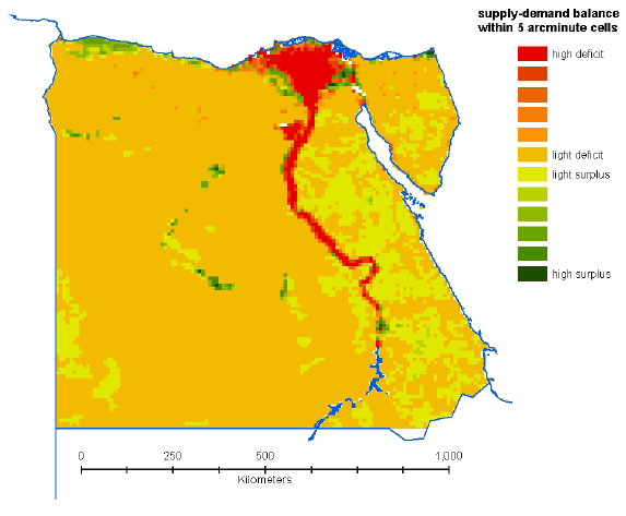
The list of the sub-national units of Egypt presenting marked deficit conditions are reported in Annex 4.
Figure 32: Eritrea. Map of woodfuel supply-consumption balance categories.
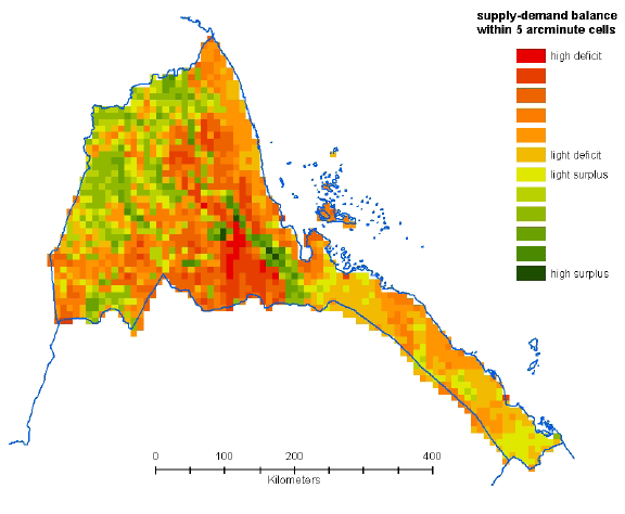
The list of the sub-national units of Eritrea presenting marked deficit conditions are reported in Annex 4.
Figure 33: Kenya. Map of woodfuel supply-consumption balance categories
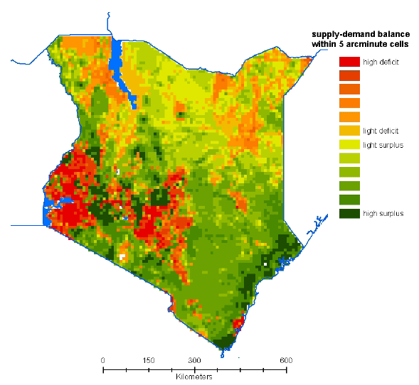
The list of the sub-national units of Kenya presenting marked deficit conditions are reported in Annex 4.
Figure 34: Rwanda and Burundi. Map of woodfuel supply-consumption balance categories
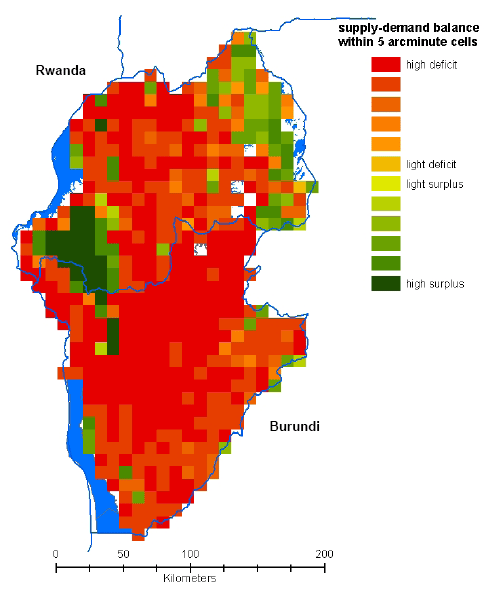
The list of the sub-national units of Rwanda and Burundi presenting marked deficit conditions are reported in Annex 4.
Figure 35: Somalia. Map of woodfuel supply-consumption balance categories.
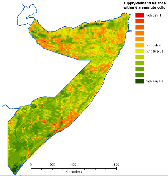
The list of the sub-national units of Somalia presenting marked deficit conditions are reported in Annex 4.
Figure 36: Sudan. Map of woodfuel supply-consumption balance categories.
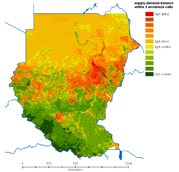
The list of the sub-national units of Sudan presenting marked deficit conditions are reported in Annex 4.
Figure 37: Tanzania. Map of woodfuel supply consumption balance.
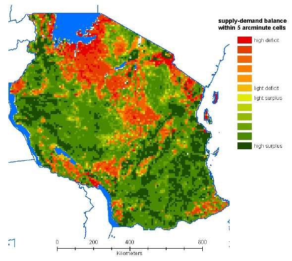
The list of the sub-national units of Tanzania presenting marked deficit conditions are reported in Annex 4.
Figure 38: Uganda. Map of woodfuel supply consumption balance categories
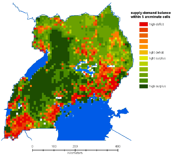
The list of the sub-national units of Uganda presenting marked deficit conditions are reported in Annex 4.
Figure 39: Regional map of average balance categories by sub-national administrative units derived from cell-level analysis.
Annex 4 lists, for each country, the sub-national units presenting marked deficit conditions.
Figure 40: National maps of Kenya, Uganda, Rwanda and Burundi with average balance categories by sub-national administrative units.

8 The consumption includes
fuelwood and wood used for charcoal production.
9 Rural areas with population
density below 2000 inhabitant / km2.
10 Rural settlements
are defined as rural areas with over 2000 inhabitants /km2.
