![]()
![]()
by
T. STROMME
INSTITUTE OF MARINE RESEARCH
BERGEN 1983
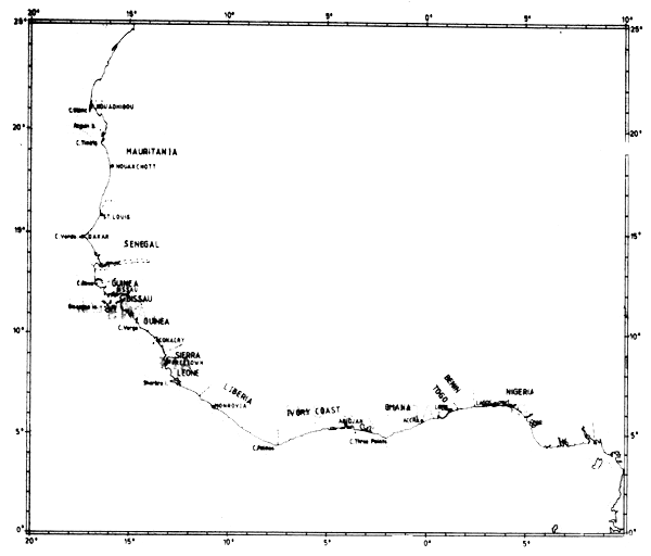
Common geographical sites referred to in the report.
Hydrography by J. Blindheim
Drawings by H. Kismul and S. Myklevoll
In the period May 1981 - April 1982 the R/V “Dr. Fridtjof Nansen” operated in West African waters from Morocco to Ghana where the work formed part of the project UNDP/FAO GLO/79/011. A planning meeting was held in Casablanca in January 1981 where the following objectives were agreed upon:
to contribute to information on abundance, distribution and composition by species, size and age of fish stocks;
to study behaviour and other biological characteristics of the fish species in the area;
to contribute to improved methodology for acoustic surveys in this area.
During the period in West African waters 10 surveys were carried out:
Survey of the pelagic community from Cape Blanc to Cape Verga, May 1981.
Survey of the pelagic community from Cape Verga to Cape St. Paul, June 1981.
Survey of the small pelagic and demersal fish resources from Togo to Point Noire, August 1981.
Survey of the pelagic community from Bissagos Islands to Cape Blanc, September 1981.
Survey of the small pelagic and demersal fish resources in the coastal waters of the Republic of Cape Verde, November 1981.
Survey of the small pelagic fish resources in the coastal waters of Mauritania, December 1981.
Survey of the fish resources in the coastal waters outside 12 nm limit in Western Sahara, December 1981.
Survey of the pelagic community from Freetown to Cape Blanc February-March 1982.
Survey of the fish resources in the coastal waters outside 12 nm limit in Western Sahara, March 1982.
Survey of the small pelagic fish resources between Cape Juby and Agadir, March 1982.
The scientific programme was planned and conducted in close cooperation with FAO, the CECAF Secretariat and the relevant research organisations in the countries concerned. Preliminary results from the surveys have been presented in short cruise reports, and in a progress report submitted February 1982.
The present report is the final report on all surveys mentioned above except No. 3 (Togo - Point Noire) and No. 5 (Cape Verde Islands)1 for which separate reports have been prepared and issued. This report thus represents the results from the coastal shelf area from Morocco to Ghana, with the main survey effort in the area Cape Blanc - Cape Verga, and single coverings of the shelf areas off Liberia - Ghana and Morocco. The work undertaken in accordance with point c) in the objectives includes the introduction of systems for instrument calibration, intercalibration with other vessels and collection of special acoustic observations during surveys. Some results on these matters are given in the appendices, some are reported in separate papers (Saetersdal et al., 1982) and some are still in preparation.
The acoustic/exploratory fishing surveys which are discussed here include the following types of observations:
Acoustic system observing depth, bottom type, and fish biomass by categories.
Fishing system observing catch, its amount and composition, biological data of fish, catchability.
Oceanographic observations of ambient water characteristics (temperature, salinity, oxygen).
1 Part 2 of this present volume covers the Cape Verde area
The analysis and processing of these data provide information on the quantity and distribution of the fish resources, their composition and aspects of their behaviour and their environment. The survey system has certain limitations particularly regarding the interpretation of the acoustic observations (these will be discussed later). Similar work in other areas has, however, demonstrated that findings from these types of surveys can provide good but often conservative indications of the availability of fish resources.
Plan
The original purpose was to cover the whole shelf between Cape Blanc and Angola twice if possible. At a later date, however, it was decided to put the main effort on the area off Northwest Africa, between Cape Blanc and Cape Verga. North of Cape Blanc, off Western Sahara jurisdictional problems prevented standard acoustic surveys with trawl sampling. But two partial coverings outside the 12 nm limit were carried out without trawling for identification and provided data for a rough assessment of the fish abundance in the area.
A generator malfunction shortened the Togo - Congo survey (separate report) by a week, and propellor damage during the Cape Verde Islands survey limited the following December survey to only the shelf area from Cape Verde and northwards. Except for this, all surveys were completed in accordance with the plans.
The survey coverages
Figures 1–10 show the cruise tracks and stations worked on all surveys in sequential order. The operational characteristics of the surveys are summarized in Table 1, where the Togo - Congo survey and Cape Verde Islands survey have also been included, to permit an overview of the programme off West Africa. Total distance steamed was approximately 35500 nm of which 30700 represented acoustic survey routes on the continental shelf. The mean daily distance advanced was 160 nm in 189 effective survey days. Unexpected time loss was 10 days. Further conclusions regarding the efficiency of the vessel can be extracted from Table 1.
Figure 11 gives an overview of the timing of the surveys off the different countries. Mauritania is the best investigated area with four coverages, Senegambia and Guinea with three coverages and Guinea Bissau, Sierra Leone and Western Sahara with two coverages. The rest of the region is only covered once.
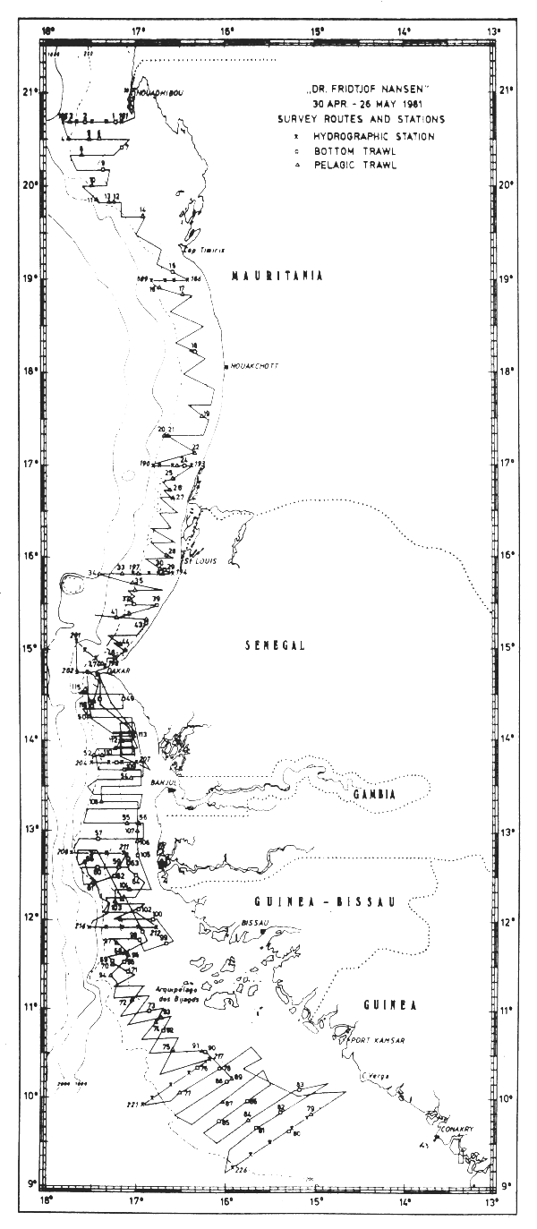
Fig. 1 Survey routes and stations. Apr 30 - May 26 1981.
The acoustic system was calibrated four times during the whole period, and four intercalibrations were performed with the R/V “Capricorne” in May-81 and Feb-82, with the R/V “Ibn Sina” in Apr-81 and with the R/V “Cornide de Saavedra” in Apr-82.
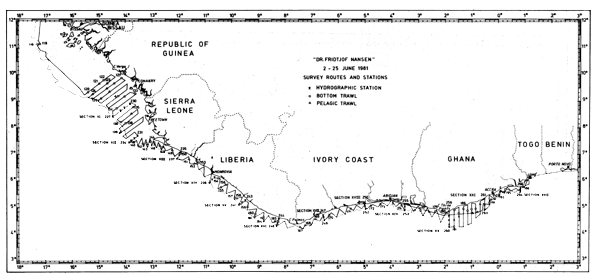
Fig. 2 Survey routes and stations. June 2–25 1981.
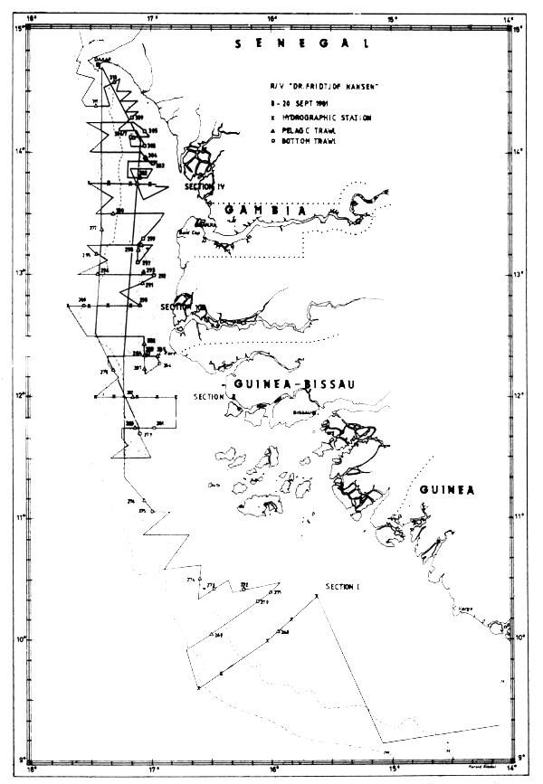
Fig. 3 Survey routes and stations. Sept 8–12 1981.
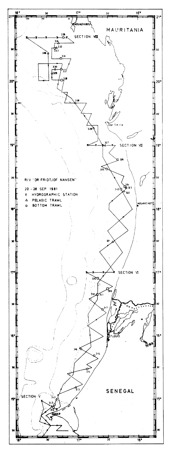
Fig. 4 Survey routes and stations. Sept 20–28 1981.
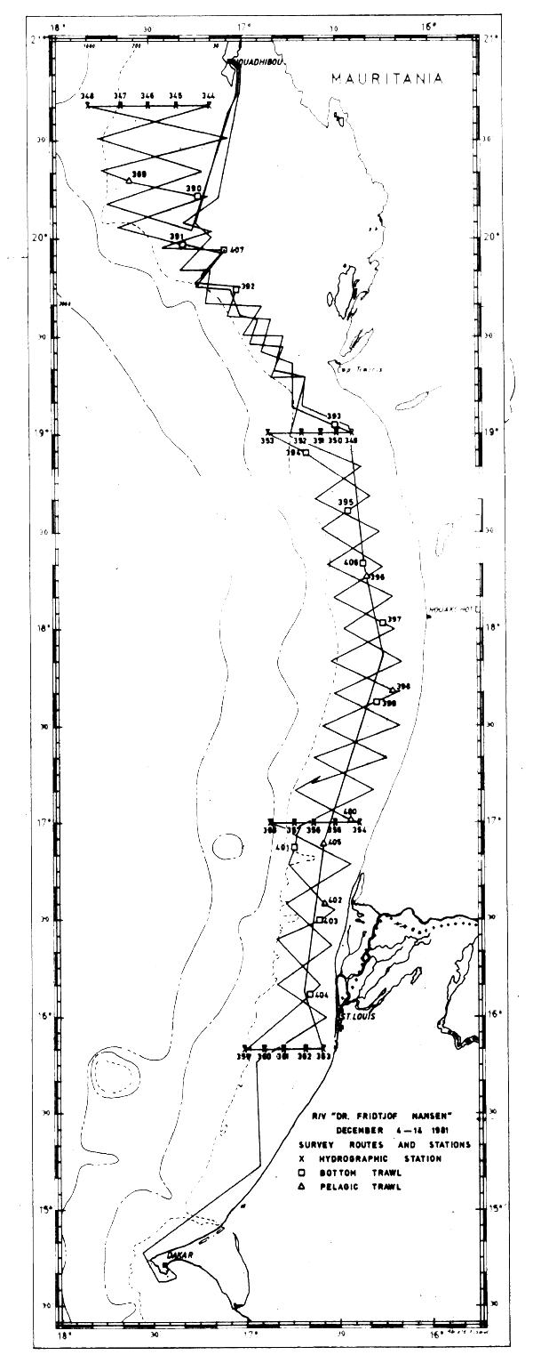
Fig. 5 Survey routes and stations. Dec 4–14 1981.
| Cruise no | Location | Dates | Days at sea | Distance travelled in survey area (nm) | Number fishing stations | Hydro-graphic stations |
|---|---|---|---|---|---|---|
| 1 | Cape Blanc - Cape Verga | 25/4 – 26/5–81 | 29 | 4600 | 114 | 46 |
| 2 | Cape Verga - Cape St. Paul | 1–25/6–81 | 23 | 4450 | 86 | 40 |
| 3 | Togo - Congo | 4/8 – 3/9–81 | 23 | 3340 | 65 | 16 |
| 4 | Bissagos Islands - Cape Blanc | 4–30/9–81 | 25 | 4020 | 80 | 34 |
| 5 | Cape Verde Islands | 3/11 – 2/12–81 | 22 | 2700 | 43 | 27 |
| 6 | Mauritania | 4–14/12–81 | 10 | 2100 | 19 | 20 |
| 7 | West-Sahara | 15–19/12–81 | 4 | 740 | - | - |
| 8 | Sherbo Island - Cape Blanc | 8/2 – 17/3–82 | 34 | 6180 | 96 | 39 |
| 9 | West-Sahara | 17–20/3–82 | 3 | 750 | - | - |
| 10 | Cape Bojador - Agadir | 20/3 – 5/4–82 | 16 | 1860 | 9 | - |
| Total survey time, distance in survey area and stations worked | 189 | 30740 | 511 | 222 | ||
| Lay-up of vessel, days | 119 | |||||
| Transfer of vessel, days and distance | 10 | 4750 | ||||
| Unexpected stop due to repair | 10 | |||||
| Days in period 25/4–81 – 5/4–82 | 345 | |||||
| Days in harbour except from lay-up and repair | 17 | |||||
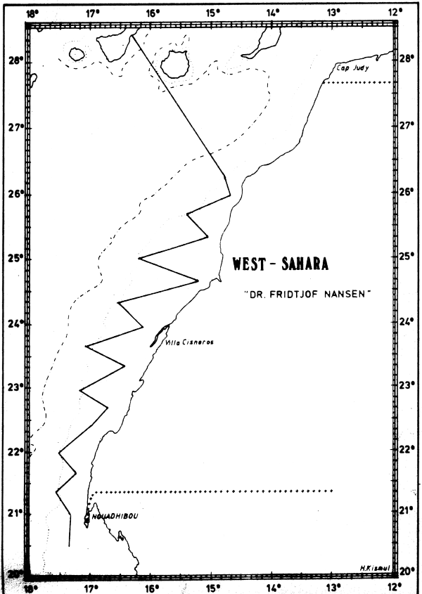
Fig. 6 Survey routes off Western Sahara. Dec 15–19 1981
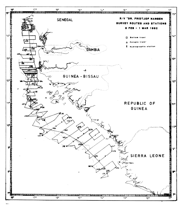
Fig. 7 Survey routes and stations. Feb 8 - Mar 1 1982.
The distance between the main acoustic transects was generally 10 nm and the shelf was usually surveyed from 10 m out to the 200 m depth limit. In Feb-82 the area off the Bissagos Islands was extended to the 500 m depth contour in order to study the deep-sea community.
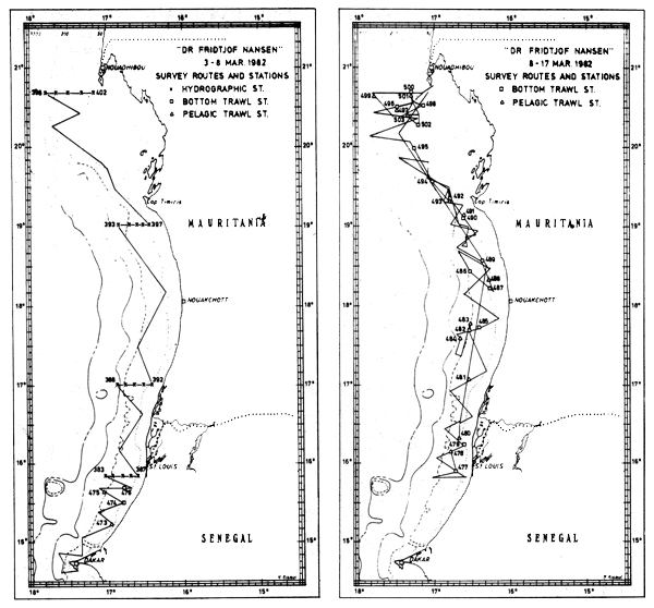
Fig. 8 Survey routes and stations. Mar 3–8 Mar 8–17 1982.
Estimates have been made of the area covered by the investigations, based on the distribution of the survey grids given in Figures 1–10, and these are shown in Table 2. Since the main fish distribution is limited to the shelf area, the shelf area covered by the survey has also been calculated. The outer regions of the shelf (to the defined limit of 200 m depth contour) have generally been fully covered, but the inshore shallow parts could often not be covered because of a safe operation depth limit of about 10 m for the ship. Quite frequently this limit had to be set to 20 m due to lack of detailed navigational charts for the area. Estimates have been made of the extent of the shallow inshore shelf left uninvestigated in the various countries. The estimates of the total fish biomass are adjusted for these areas omitted from the surveys.
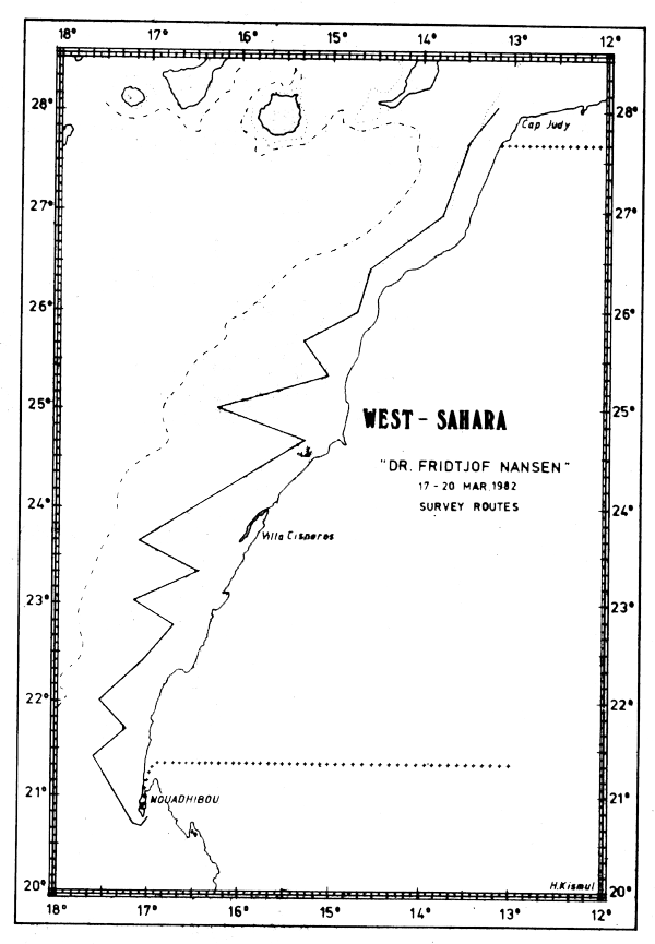
Fig. 9 Survey routes. Mar 17–20 1982.
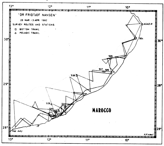
Fig. 10 Survey routes and stations. Mar 20 - Apr 3 1982.
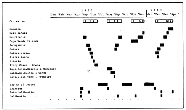
Fig. 11 Work calendar for R/V “Dr Fridtjof Nansen” off West Africa 1981–82.
| Area/Period | Shelf area 0 – 200m (nm2) | Shelf area covered (nm2) | Shallow Shelf area (nm2) | Nautical miles | Survey intensity nm/100 nm2 |
|---|---|---|---|---|---|
| Marocco/Mar-82, 2 coverings Cape Juby-Agadir | 4800 | 4300 | 500 | 1680 | 39 |
| West Sahara/Dec-81 | 18200 | 12600 | 5600 | 740 | 6 |
| /Mar-82 | 18200 | 11800 | 6400 | 750 | 6 |
| Mauritania/May-81 | 10700 | 7100 | 3600 | 900 | 13 |
| /Sept-81 | 10700 | 6900 | 3800 | 1160 | 17 |
| /Dec-81, 2 coverings | 10700 | 7300 | 3400 | 2110 | 29 |
| /Mar-82, 2 coverings | 10700 | 7000 | 3700 | 1260 | 18 |
| Senegambia/May-81 | 9700 | 6800 | 2900 | 1730 | 25 |
| /Sept-81 | 9700 | 7600 | 2100 | 1650 | 22 |
| /Feb-82 | 9700 | 6400 | 3300 | 870 | 14 |
| Cape Verde Islands/Nov-81 | 1450 | 1450 | - | 2000 | 43 |
| Guinea-Bissau/May-81 | 11900 | 6100 | 5800 | 1160 | 19 |
| /Sept-81 | 11900 | 6400 | 5500 | 640 | 10 |
| /Feb-82 | 11900 | 7200 | 4700 | 1130 | 16 |
| Guinea/May-June-81 | 13800 | 10300 | 3500 | 1380 | 13 |
| /Sept, partial covering | 10200 | 4500 | 5700 | 224 | 5 |
| /Feb-82 | 13800 | 8600 | 5200 | 900 | 10 |
| Sierra Leone/June | 8100 | 5800 | 2300 | 815 | 14 |
| /Feb-82, partial cov. | 2600 | 355 | 14 | ||
| Liberia/June-81 | 5700 | 5200 | 500 | 690 | 13 |
| Ivory Coast/June-81 | 3600 | 3000 | 600 | 475 | 16 |
| Ghana/June-81 | 7100 | 6600 | 500 | 1310 | 20 |
| Togo-Congo/Aug-81 | 32700 | 20400 | 11900 | 2075 | 10 |
| All surveys | 165950 | 26000 | 16 |
Estimates of survey intensity are also shown in Table 2, given as ratios between nautical miles steamed and 100 nautical miles2 covered for the various countries.
The surveys off Morocco, Cape Verde Islands and the Dec-81 survey in Mauritania stand out as the most intensively surveyed areas, and in fact the areas were investigated twice during these surveys. On the lower side of the scale are the preliminary surveys off West-Sahara with only 6 nm travelled per 100 nm2 covered. The other surveys are dispersed in the range 10–25 nm/100 nm2 and with a mean of 16 for all surveys.
The precision in biomass estimates from acoustic surveys is based on a number of factors which can be summarized in the following key-words:
Detection
Screening effect
Representative sampling
Identification
Conversion factors
Detection
Assessing fish biomass by means of acoustic data is a method which especially lends itself to fish found in schools or other aggregations in midwater. The dominant species in West African waters, in terms of biomass, exhibit this type of behaviour. On the other hand surface schooling tunas and tuna like species and strictly bottom-dwelling fish such as rays and flounders will escape echo sounder detection. Also any fish found within 1/2–1 m of the bottom will not be observed by the acoustic system. Recent analysis on paired data from acoustic and trawl surveys (Saetersdal et al. (1983)) indicate that the bias due to lack of information from this zone may be less than earlier expected. For the dominant species in West African waters there does not seem to be any major problem in acoustic detection.
Screening effect
In areas with high densities of plankton it is difficult for the scientists assessing the echotraces to distinguish registrations of fish from those of plankton, and this is still more arduous when the fish densities are low. In West African waters the plankton did not cause any major problems during the surveys northwest of Liberia, but from there to the Congo the plankton occurrences often shaded the generally scattered fish registrations, and the precision of the biomass estimates was significantly affected.
Representative sampling
In all kinds of sampling work it is important that the sampling device does not significantly affect the distribution in situ. However, it is likely that a 150 foot vessel with a 1500 hp engine like “Dr. Fridtjof Nansen” does have an effect on the behaviour of the fish. If the fish dives in response to the approaching vessel, the echo received will change according to the downward angle of the fish, and if the fish swims perpendicular to the ship's track, it may totally escape echo sounder detection.
The problem of avoidance increases in shallow waters and is especially valid during day time and for the fast swimming species. The phenomenon may constitute a serious problem in acoustic surveys and, although investigations have been made, no means of quantification exists. We have therefore in this report not corrected for avoidance. The biomass estimates are therefore likely to be underestimates, especially in the cases of the sardinellas and horsemackerel. Conversely, the triggerfish (Balistes capriscus) seems not to respond significantly to the vessel, which makes it quite amenable to acoustic investigation.
Identification
The problem of adequate sampling is also relevant when trawling on multi-species fish registrations in order to identify the traces and allocate the density figures to the different species. The fish's catchability may be species- and size dependent, and trawl data must be used with reservations when allotting the echo integrator values to the different species.
During the daily judgements of the echo traces the integrator values were allocated to five main groups: a) plankton, b) clupeoids and anchovies, c) horsemackerels and scads, d) triggerfish and e) other fish. The separation was made partly on basis of the characteristics of the traces and partly on the composition of the catches. If the integrated densities within an area are made up of fish from several of these categories, it is evident that misallocations can occur, especially if the fishes' reactions to the gear are disparate. Thus the total abundance estimates are more reliable than the ones on a more specific level.
In this report we have also made use of the trawl data to separately assess the dominant species' relative importance in the area, using roughly calculated abundance indices. These indices have been combined with the acoustic estimates to provide rough abundance estimates on the species level. From this it follows that the estimates for the species level must only be interpreted as very tentative and are more suggestive of orders of magnitudes than precise estimates.
Conversion factors
The output from the echo integrator gives relative values of fish density. These are to be converted to absolute biomass figures by means of a multiplication factor C which is dependent both on the size and the species of the fish. Lacking special conversion factors from West African species, we have made use of coversion data from cod and herring in our calculations. Corrections have been made for the length of the fish but not for the species.
In spite of the problems and uncertainties mentioned here, acoustic surveys have often proved to provide good if often conservative indications of the abundance of fishery resources.
![]()
![]()