![]()
![]()
![]()
General features of wind- and current conditions around the Cape Verde Islands
The Cape Verde Islands lie in the southern part of the Canary Current which runs south-westerly along the Northwest African Coast. The current direction is still south-westerly through the Cape Verde archipelago, but beyond this area it turns west and nortwest and then becomes the Northern Equatorial Current. The speed of the residual current is less than 0.5 knots (DIETRICH and ULRICH, 1968). The atmospheric circulation is dominated by the trade-wind of north-easterly direction.
Wind conditions and hydrographic conditions 18–25 november 1981
Standard meteorological observations were taken at the hydrographical stations. The wind velocity during this period was gentle to moderate breeze (4–7 m.sec-1), and the direction was constantly of NNE and NE. The wind measurements from the hydrographic stations around the eastern archipelago (Fogo-Sal) is somewhat more northerly than from the stations in the sound between S. Antao and S. Vicente. Wind speed was also higher in the sound. This may be due to the time lag of 2–4 days between the measurements taken of the two areas. However, it may also be due to the local topography of the two islands S. Antao and S. Vicente, which may give a change of wind direction and an increase of wind speed through the sound.
During the cruise 27 Nansen casts were made. Temperature, salinity, and dissolved oxygen were observed at standard depths to the bottom or maximum 500 m.
In the upper wind-mixed layer the temperature is about 0.7°C lower at the west side of the archipelago Fogo-Sal, while salinity is somewhat higher. At most stations both temperature and salinity decrease towards the bottom. However, in the basin to the west of Fogo-Sal a layer of high saline water exists, about 50 m thick, with the core at about 75 m depth (Fig. 4). T-S analysis of the data shows that this water mass is also present on the east side, but here it is less pronounced.
Fig. 3, 4 and 5 show temperature, salinity and density of the João Valente Bank section. The bank seems to have influence on the vertical circulation. Upwelling occurs at the western edge. It seems to be most vigorous down to 150 m depth, but the salinity distribution indicates that it occurs to a less extent down to 300 m depth.
At the eastern edge of the bank the opposite prosess, downwelling, seems to occur below 125 m depth.
The upper mixed layer extends down to about 30 m depth around the Cape Verde islands. Above the João Valente Bank, it is considerably deeper, extending here to about 50 m depth. The deepening of the mixed layer above the bank is most probably due to higher vertical turbulence generated by waves and current. In the same way the upwelling at the western edge and downwelling at the eastern edge may be explained by an obstacle effect on the eastwest component of the upper layer current.
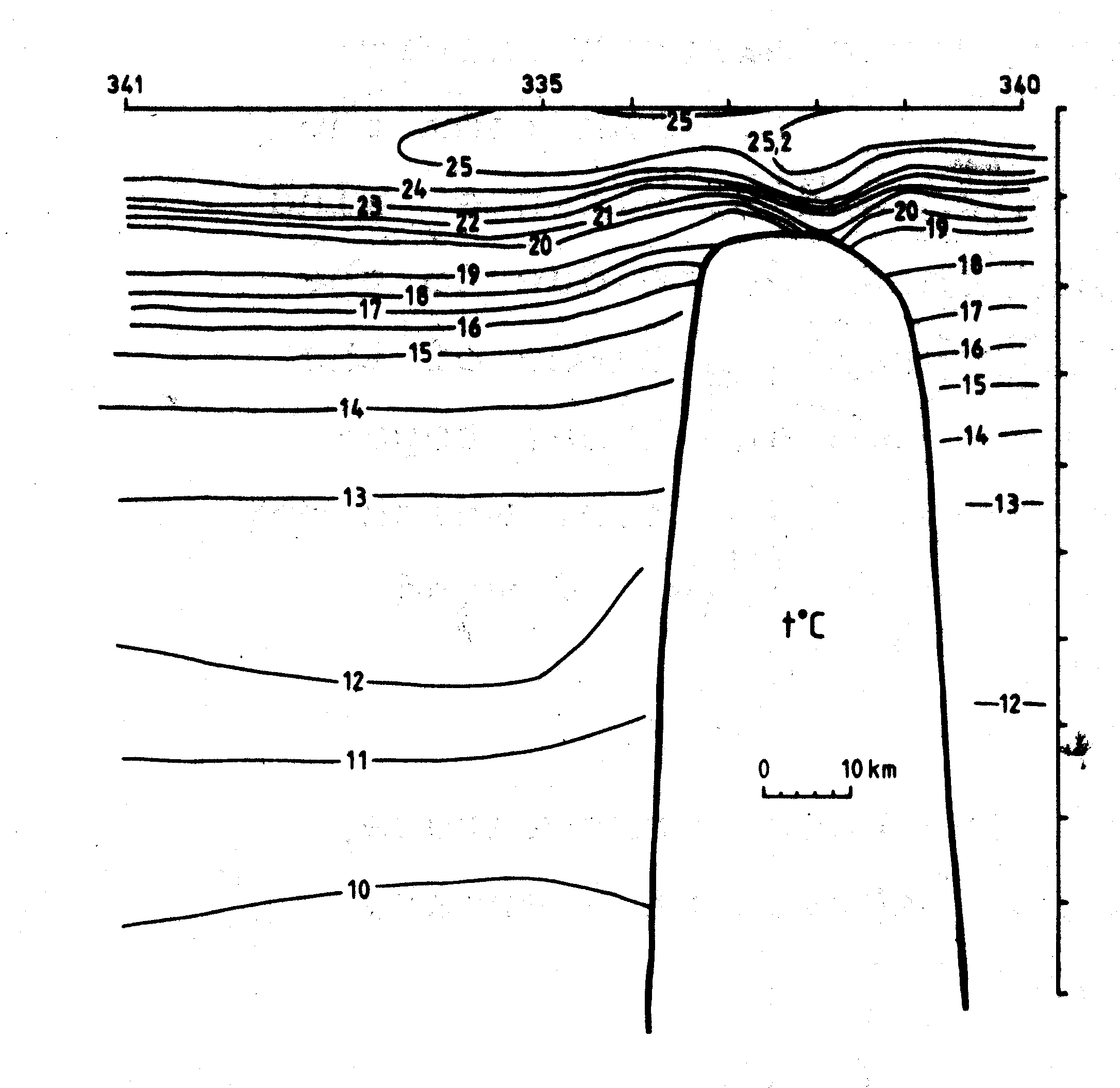
Fig. 3. Temperature, t°C, at the Jo&ão Valente Bank section 23 November 1981.
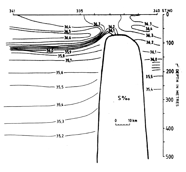
Fig. 4. Salinity, S%2, at the João Valente Bank section 23 November 1981.
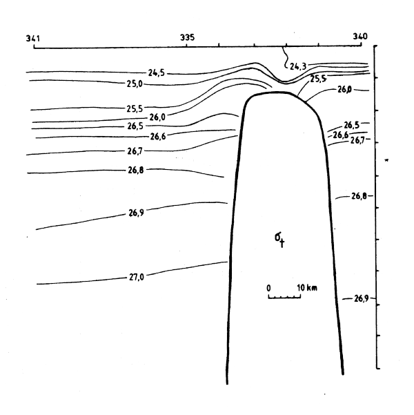
Fig. 5. Density, G, at the Joño Valente Bank sectio 23 November 1981.
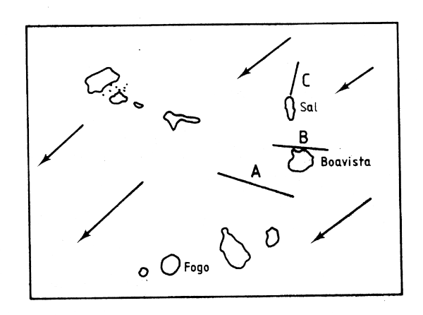
Fig. 6. General features of the Current of the upper layer.
The João Valente Bank hydrographic section.
The Boavista hydrographic section.
The Sal Hydrographic section.
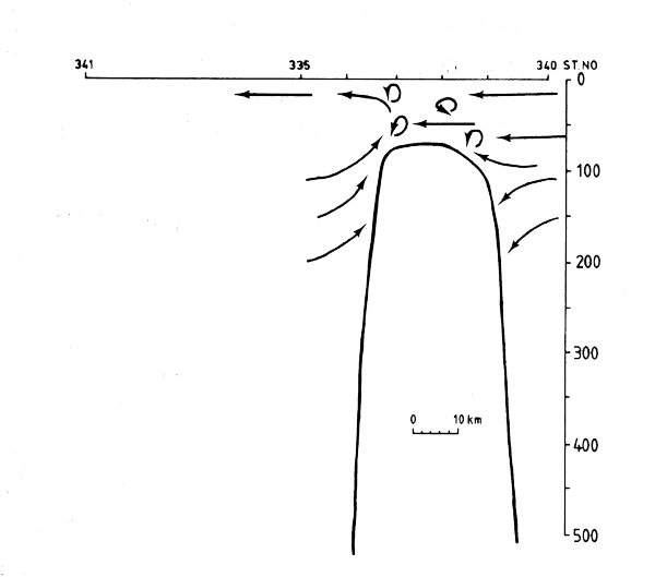
Fig. 7. Tentative vertical circulation across the João Valente Bank November 1981.
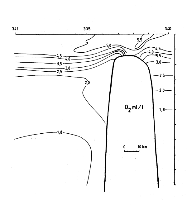
Fig. 8. Oxygen, ml/l, at the
João Valente Bank section.
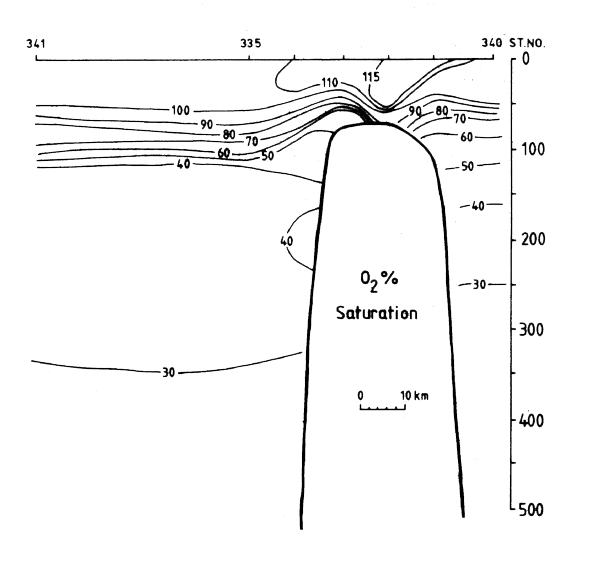
Fig. 9. Oxygen, % saturation, at teh João Valente Bank section.
In Fig. 6 the residual current direction is drawn after DIETRICH and ULRICH (1968). Fig. 7 shows the vertical circulation around the João Valente Bank as described above.
The oxygen distribution at the João Valente Bank section shows similar features as the density distribution, indicating upwelling of oxygen poor water on the western edge. Fig. 8 and 9 show oxygen distribution in ml/1 and percent saturation, respectively. The upper well mixed layer above the bank has very high concentrations of oxygen (120 percent saturation) indicating high primary production. This must be caused by the combined effect of upwelling and mixing bringing nutrient rich water into the euphotic zone.
The Boavista section shows similar features as the João Valente Bank section, but both upwelling and mixing of the upper layer above the shallow area are less pronounced here. This may, however, be an effect of the position of this section at the north part of the bank.
The surface temperature is shown in Fig. 10.
Fig. 11 shows the distribution of trawlable and non-trawlable bottom inside the 200 m depth contour. The evaluation is based on the degree of smoothness of the recordings from the echo sounder observations and on hauls with the bottom trawl gear. Only the Maio-Boavista shelf has appreciable areas suitable for trawling. A small patch southeast of Sal is also trawlable.
Fig. 10. Temperature °C in Surface layer.
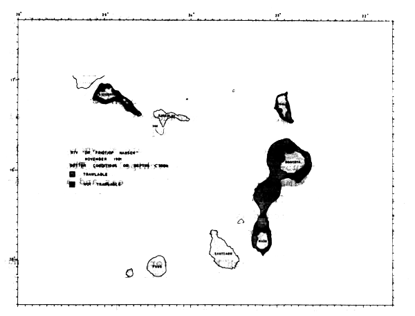
Fig. 11. Bottom conditions at depths less than 200 m.
Figures 12 and 13 show the distributions of fish found during the first and second coverage respectively. The main species in the area when identified by fishing is marked off with a species code in Fig. 12.
Based on the characteristics of the echotraces and partly on the composition of the catches the indices of abundance were split into pelagic and demersal fish. This is a customary classification based on the distributional- and feeding behaviour of the various fish species. The criteria on which the separation is made are, however, uncertain and too much confidence should not be placed in these sub-estimate.
One result of the survey is the demonstration that the distribution of small pelagic and demersal fish is closely restricted to the shelf regions of the islands. No significant recordings of commercial fish were made over the deepwater areas between the islands. One should note, however, that this type of survey is not suitable for large pelagic fish such as tunas, and a possible occurrence of these would not be shown.
The observations of echo-intensity have been converted to measures of fish density in accordance with the conventional method described in Annex V. By area integration estimates of fish biomass are obtained and these are shown in Table 1 split on four sub-areas within the archipelago. The table includes approximate estimates of shelf areas and a calculation of the mean fish density inside the shelf, although this measure of productivity per unit shelf area may be of limited relevance in archipelagos with narrow shelves.
The estimate of total fish biomass for the Cape Verde Islands is 100 thousand tonnes of fish. Of this about half is allocated to pelagic species, mainly the scadsDecapterus macarellus, D. punctatus and D. rhonchus.
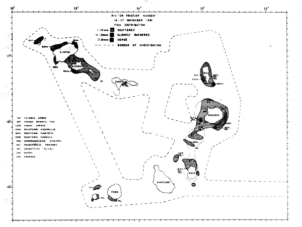
Fig. 12. Fish distribution 16 – 27 November 1981. Echo-intensity by levels of integrator deflection.
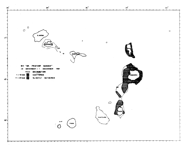
Fig. 13. Fish distribution 28 November - 1 December 1981. Echo-intensity by levels of integrator deflection.
The islands Fogo and Santiago had only some faint recordings of fish, and the total estimate of 1 500 tonnes is considered to be of very low precision.
The shelf around Sto. Antao, S. Vicente and S. Nicolau contained about 20 thousand tonnes of fish. The pelagic contribution to this is about 15 thousand tonnes, which is mainly Decapterus macarellus around S. Vicente. The amount of demersal fish in the catches in this area is too low to provide any basis for assessment of species composition and distribution.
The shelf around Sal is approximate 150 nm2. The estimate from the first covering is 9 thousand tonnes of fish. The dominating species were Decapterus macarellus, D. punctatus and Sardinella maderensis.
The shelf around Boavista and Maio and between the two island is 850 nm2 and comparises about 60% of the total shelf area belonging to Cape Verde Islands. This makes the area the most interesting in terms of fishary resources. The two repeated surveys of this area resulted in very similar assessments of total fish biomass: 69 thousand tonnes and 64 thousand tonnes respectively.
15 bottom trawl hauls were carried out around the islands Sal, Boavista and Maio. Though some of the hauls were aimed at fish concentrations identified by echo-sounders and thus not statistically random, a biomass estimate based on the catches and are swept by the trawl could give some tentative measure.
With a total shelf area around these islands of about 1 000 nm2 a “swept area-estimate” of about 20 thousand tonnes of demersal fish is obtained. This is based on an assumed catchability coefficient q equal to one for the area between the wing ends of the trawl.
Catches of pelagic schooling species such as scads in the bottom trawl hauls have been excluded in these assessments. As shown in Table 1 the acoustic estimate of demersal fish on the Sal, Boavista, Maio-shelf is about 43 thousand tonnes. In contrast to the trawl estimates the acoustic assessment will include demersal type of fish traces which occur above the near-bottom layer of about 6 m covered by the trawl. It may on the other hand also include some pelagic fish with distributional characteristics similar to those of demersal fish. The best estimates of demersal fish on this shelf part is probably 20–30 thousand tonnes which leaves 50–60 thousand tonnes of pelagic fish.
The pelagic resources around Boavista and Maio are mainly made up of the species Decapterus punctatus, D. macarellus, D. rhonchus and Sardinella maderensis, mentioned in order of importance.
The demersal fish were mainly representatives of the families Sparidae, Mullidae, Acanthuridae, and Caproidae.
The records of the fishing operations are shown in Annex II. The catch rates in the 15 successful bottom trawl catches are shown in Table 2. The high catches consisted mainly of scads. Also generally the carangids dominated the catches, being present in 65% of the trawl hauls as shown in Table 3. Other common families were Sparidae and Mullidae.
The pelagic trawl hauls are of less interest from a fishing operations point of view as they were made mainly for the purpose of identifying acoustic scatterers.
A total of 8 bottom line trials of 300–400 hooks each yielded catches from 0 to abt 80 kgs mostly small sized sharks.
| Pelagic (103 tonnes) | Demersal (103 tonnes) | Total (103 tonnes) | Shelf area 0–200 m (nm2) | Mean density (tonnes/nm2) | |
|---|---|---|---|---|---|
| Fogo, Santiago | 1 | 0.5 | 1.5 | - | - |
| Sto Antao, S. Vicente, S. Nicolau | 15 | 5 | 20 | 440 | 45.8 |
| Sal, Boavista, Maio, first covering | 34 | 43 | 77 | 1008 | 76.8 |
| Sal, Boavista, Maio, second covering | - | - | 79 | 1008 | 78.6 |
| Total Cape Verde Islands | 50 | 50 | 100 | 1447 | 69.1 |
| Catch (kgs) | 0–100 | 100–200 | 400–500 | 500–1000 | Abt 2000 | Abt 4000 | Abt 6000 |
|---|---|---|---|---|---|---|---|
| No hauls | 3 | 1 | 1 | 7 | 1 | 1 | 1 |
| Catch grouping: kg/hr | 1–9 | 10–49 | 50–199 | 200–499 | >500 | % incidence in total no of hauls | Mean | % of total catch |
|---|---|---|---|---|---|---|---|---|
| TRAWL: BOTTOM NO OF HAULS : 17 | ||||||||
| FAMILY: | ||||||||
| CARANGIDAE | 0 | 4 | 1 | 2 | 4 | 65 | 1050.3 | 59 |
| SPARIDAE | 0 | 1 | 3 | 4 | 1 | 53 | 301.5 | 14 |
| MULLIDAE | 2 | 0 | 4 | 1 | 1 | 47 | 212.6 | 9 |
| CAPROIDAE | 2 | 1 | 1 | 2 | 1 | 41 | 233.3 | 8 |
| POMADASYIDAE | 0 | 1 | 2 | 0 | 0 | 18 | 100.0 | 2 |
| SHARKS | 0 | 5 | 1 | 0 | 0 | 35 | 50.3 | 2 |
| ACANTHURIDAE | 0 | 0 | 0 | 1 | 0 | 6 | 248.0 | 1 |
| DACTYLOPTERIDAE | 4 | 3 | 1 | 0 | 0 | 47 | 16.4 | 1 |
| FISTULARIDAE | 5 | 1 | 1 | 0 | 0 | 41 | 13.1 | 1 |
| MACROURIDAE | 1 | 0 | 0 | 1 | 0 | 12 | 131.6 | 1 |
| PRIACANTHIDAE | 2 | 1 | 1 | 0 | 0 | 24 | 44.5 | 1 |
| Other fish | - | - | - | - | - | - | 30.7 | 2 |
| TOTAL | 0 | 0 | 3 | 1 | 11 | 88 | 1155.2 | |
| GEAR: PELAGIC NO OF HAULS : 17 | ||||||||
| FAMILY: | ||||||||
| CARANGIDAE | 2 | 3 | 4 | 1 | 0 | 59 | 71.2 | 49 |
| MYCTOPHIDAE | 0 | 1 | 1 | 0 | 1 | 18 | 228.2 | 47 |
| CLUPEIDAE | 1 | 1 | 0 | 0 | 0 | 12 | 8.7 | 1 |
| Other fish | - | - | - | - | - | - | 2.0 | 2 |
| TOTAL | 1 | 6 | 6 | 1 | 1 | 88 | 85.2 | |
This category of fish consists of small-sized species of less than 10 cm total length which occur in layers at water depths of 200–600 m, but often rise to the surface layers at night. On all the off-shelf tracks in the archipelago observation of mesopelagic fish formed part of the programme. They were found to occur over wide areas, but nowhere in rates of abundance which might indicate a resource of commercial interest. Catches up to 600 kg/hr were obtained in pelagic trawl hauls, consisting mostly of Myctophids.
Decapterus macarellus
This scad was the dominating species in the northern part of Cape Verde Islands. It was caught west of Sto. Antao, around S. Vicente, west of Sal and around Boavista. The highest concentrations were found south of S. Vicente and east of Sal (st. 357). All catches were made with pelagic trawl. The best catch was 136 kg/hr, but this do in no way indicate the best possible catches, as fishing were carried out only to identify the echo targets. Decapterus macarellus was found on five stations around Boavista, but in low quantities only. The species was here mixed with Decapterus punctatus of which the last was clearly the dominating one. In the region Sal - Boavista the mean length in the samples were within the range 17.4 – 20.1 cm, while in the Sto. Antao S. Vicente region the mean ranged from 25.2 to 28.1 cm.
Decapterus punctatus
was found around Sal, Boavista and Maio. The best concentrations were on the south-eastern part of Boavista, where good schools formed during the day, and a dense scattering layer during the night. The biomass estimate for these dense concentrations is 6500 tonnes. The best catches of Decapterus punctatus were also obtained from these concentrations with 4.8 and 3.9 tonnes/hour. Mean lengths were in the range 11.5 – 21.3 cm. No clear size-dependent distribution could be seen from the samples, but samples from the dense concentrations southeast of Boavista gave mean lengths of 11.2 and 11.5 cm. It is interesting to note that Decapterus punctatus had its center in terms of density southeast of Boavista while D. macarellus was concentrated south of S. Vicente. Only on some part of the shelf off Boavista did the two species mix somewhat, but then only with very disperse concentrations of Decapterus macarellus. The separate habitats of the closely related species seems to be a way to avoid a competitive exclusion, though no hydrological or biological differences is found to explain the phenomenon.
Decapterus rhonchus
The false scad was caught on five stations north and southeast of Boavista. Except two catches of 842 and 81 kg/hr respectively, only scattered specimens were caught. The mean length in samples were from 15.6 to 26.8 cm. The species do not seem to form an important part of the total biomass of pelagic fish.
Sardinella maderensis
Was caught on four locations around Sal and Boavista, but only in small quantities (max. 32 kg/hr). Mean lengths in samples were from 14.5 to 22.4 cm.
Caranx crysos
The blue runner was caught and identified on one location only, on the bank 15 nm northwest of Maio. The species is too fast-swimming to be trapped in the trawl gear used, but was caught on two settings with bottom long line. The fish formed dense schools during the day, easily detected by the echosounders. 26 specimens (37 kg) were caught on 400 hooks. The size range was from 41 to 64 cm.
Sharks
The sharks caught in the area were mainly Mustelus mustelus and Rhizoprionodon acutus. They were caught both in bottom trawl and on bottom long line. The species were caught on nine fishing stations around Sal, Boavista and Maio. The best catch was on a 300 hook, long line station just west of the João Valente Bank (st. 363). The catch was 35 sharks of 79 kg.
Other fish
Pseudupeneus prayensis was caught on 8 locations. The best catches were 1070 and 212 kg/hr. The mean lengths from five samples were within the range 16–20 cm. The commercial valuable groupers Epinephelus guaza and E. alexandrinus were caught only on two locations, st. 364 and st. 370.
![]()
![]()
![]()