![]()
![]()
![]()
Ecological park saves an archaeological heritage
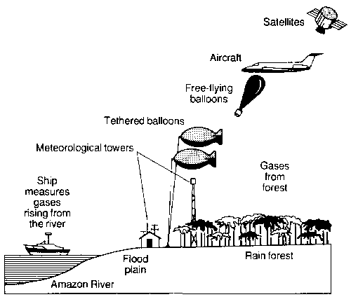
Measuring forest's breath
It would be hard to list all the uses of plants, or all the benefits to be derived from them. However, with the advance of research, new uses and properties are constantly being discovered.
A team fielded by the Istituto per il Medio ed Estremo Oriente (Middle and Far East Institute - ISMEO), La Fondazione Lerice (Lerice Foundation) and the University of Rome, in collaboration with the University of Aachen in the Federal Republic of Germany, has recently been working in the Sind region of Pakistan, unearthing traces of the Harappan civilization in Mohenjo-Daro.
A contemporary of the great Mesopotamian cities, Mohenjo-Daro lies buried beneath the valley of the Indus River. It was built 2000 years before Christ, with the material ready to hand - clay on huge platforms to protect it from the frequent flooding of the Indus. Mohenjo-Daro is still something of an enigma, since no examples of writing have been found. In the construction of the city, bricks made of baked clay were used for the first time. Its architecture is considered fairly advanced, and both the road network and the sewerage and drainage system were well organized.
Since the beginning of this century, many attempts have been made to bring to light the mysteries it encloses. Archaeologists excavating the ruins have encountered the following problem: the level of the ground water has changed, and is at present nearer the surface. The water has risen through the walls, depositing in them the salts it contained. As a result, the walls have disintegrated, making any kind of excavation impossible.
In the past 20 years, Unesco has built retaining walls and drainage canals around the city and also a landing strip and a laboratory. Pumps have been installed to lower the ground-water level.
Prof. Giovanni de Marco, a geobotanist at the University of Rome, has ascertained, on the basis of a phyto-sociological study of the area, that there is a particular distribution of vegetation which enables him to "read" the terrain through the plants that grow on it. Adobe, bricks, alluvial deposit, sand and rubbish provide different substrata for the development of plants.
The research project in Brazil's Amazon basin used advanced instruments on water and land, and in the lower and upper atmosphere to measure the influence of the rain forest on atmospheric chemistry
Geobotany in the multidisciplinary context of the archaeological zone of Mohenjo-Daro has two purposes. The main one is to provide the basic information needed for the construction of an ecological park and at the same time support archaeological research.
The first step in this research is to expand existing knowledge of the vegetation, identifying the relationship between vegetation and environment (soil, salinity, moisture, climate, archaeological structures, etc.).
There are two ways in which vegetation can play a useful role in conservation of the site, namely:
· lowering the ground-water level by using phreatophyles as living pumps; and· modifying the microclimate through appropriate forestation, so as to reduce the effect of evaporation as the water rises through the walls, and reduce erosion by wind.
To achieve these purposes, species will be selected on the basis of two characteristics: auto-ecological, which means that they must be compatible with the environmental conditions of the site, and phonological, so that they will perform well in periods when the factors combining to create the effects to be controlled are at their peak.
To preserve the local flora and the landscape, the choice of species to be planted will as far as possible avoid species alien to the original surroundings, while allowing for the decorative function of plants in a park.
The trees in the Mohenjo-Daro ecological park will not only act as living pumps, helping to dry out the land for the purposes of archaeological excavation, but also ensure greater environmental stability by mitigating the effects of meteorological variations through the creation of a stable microclimate.
The presence of the trees will lead indirectly to the development of wild fauna, while the enterprise as a whole represents a new strategy for the conservation of plant genetic resources.
Griselda Gómez
In a copyrighted article by Marlise Simons, the International Herald Tribune reported on 5 June 1987 that in mid-May Brazilian and American scientists completed a six-week field operation in the tropical rain forest of the Amazon basin to investigate and measure the effects of the forest on the atmosphere.
The expedition was a joint effort between Brazil's National Institute for Space Research and the US National Aeronautics and Space Administration (NASA), in which 60 Americans and 90 Brazilians, including geologists, physicists, biologists and meteorologists, took part.
Using the latest technology, including aircraft, space satellites and laser equipment, the scientists sought to measure the types and amounts of gases, particles and other compounds that are exchanged between the forest vegetation and surrounding air. Experiments reportedly found some of the purest air and cleanest water on record.
The author wrote that, "at one forest site northwest of Manaus tests were in progress 24 hours a day. Free-flying balloons carrying instruments and a radio transmitter were launched every three hours to register ozone, temperature and moisture. Tethered balloons hovered at 500 m and 1500 m. Instruments on the ground and in towers monitored the breath of the jungle day and night as it came off the mud, the debris, the living forest and then rose up through the canopy."
The research is part of a worldwide project, sponsored by NASA, that will attempt to measure the contribution of the earth's living systems to key compounds in the atmosphere.
![]()
![]()
![]()