![]()
![]()
![]()
LUALABA FLOODPLAIN/LAKES COMPLEX (= KAMOLONDO DEPRESSION)
| Geographical data (see Fig. 5) | ||
| Location: | Zaire - 7° 45'–9° 15'S; 25'° 50'–27° 15'E | |
| Altitude: | 575 m | |
| Surface area: | 11 840 km2 | (max flooded area); |
| 7 040 km2 | (low water area, of which consists of permanent lakes and of swamps) | |
| 1 545 km2 | ||
| 4 800 km2 | ||
| (Konare, 1984): | ||
| 4 390 km2 | Bukama area | |
| 1 866 km2 | Malemba N'Kulu area | |
| 6 256 km2 | Total | |
| Max. length: | 200–250 km | |
| Major inflowing river: Lualaba | ||
| Outflowing river: Lualaba | ||
| Special features: | The Lualaba River floods an extensive plain of 250 km in length and 40 km in width. More than 50 lakes are found in this area, the most important of which are: Lakes Kabala, Kabele, Kabwe, Kalando, Kange, Kapondwe, Kasala, Kayumba, Kisale, Kiobo, Lukanga, Lunda, Mulenda, Muyumbwe, N'Sala, Sana, Sangwe, Tungwe, Upemba and Zimbabo. Of these, the largest is Lake Upemba (530 km2) (see separate entry for Lake Upemba). (Welcomme, 1972) | |
| Fisheries data |
| No. of fish species: | 37 species in 16 families (Konare, 1984) |
| Main catches: | Mormyrus, Hydrocynus, Alestes, Distichodus, Clarias, Synodontis, Lates niloticus, tilapia (Konare, 1984) |
| Total annual catch and effort: | |
| Year | Total catch (t) | No. of fishermen | No. of boats | Source |
| 1955 | 22 000* | - | - | Compere & Symoens, 1987 |
| 1959 | 16 500* | - | - | Compere & Symoens, 1987 |
| 1975 | 10 440** | - | - | Luvuande & Wosey, 1983 |
| 1976 | 11 484** | - | - | " " " |
| 1977 | 10 920** | - | - | " " " |
| 1978 | 11 233** | - | - | " " " |
| 1979 | 11 922** | - | - | " " " |
| 1980 | 10 628** | - | - | - |
| 1981 | 10 283** | - | - | - |
| 1982 | 10 000** | - | - | - |
| 1983 | 16 000* | - | - | Konare, 1984 |
| 1984 | - | 7 668* | 8 559* | Konare, 1984 |
* including Lake Upemba
** excluding Lake Upemba
Potential annual yield: 30 000 t (including Lake Upemba) (Konare, 1984)
Productivity: 50 kg/ha/yr
LAKE MAJI NDOMBE
| Geographical data (see Fig. 6a) (Welcomme, 1972; Compere & Symoens, 1987) | |
| Location: | Zaire - 2° S; 18° 20'E |
| Altitude: | 340 m |
| Surface area: | 2 300 km2 |
| Depth: | 5 m (mean) |
| Major inflowing rivers: Bowele, Lokoro, Lotoi, Olango-Lule, Olango-Nsongo | |
| Outflowing river: | Fimi, into Kwa and Congo/Zaire |
| Catchment area: | 67 680 km2 |
| Volume: | 7.109 m3 (mean); 4.109 m3 (min); 10.109 m3 (max) |
| Physical and chemical data | |
| pH: | 4.2 to 5.5 (Corsi, 1984a) |
| Oxygen: | present from surface to bottom |
| Fisheries data | |
| No. of fishermen: | 4 600 (1982) |
| Total annual catch: | 1 094 t (Welcomme, 1972) |
| 225 t in 1957 | |
| 1 500 t in 1982 (includes Lake Tumba) | |
| Potential annual yield: | |
| 10 000 t (Welcomme, 1972) | |
| 5 750 t (25 kg/ha/yr: Corsi, 1984a) (Lake Maji Ndombe) | |
| Key reference for Lake Maji Ndombe: Corsi, 1984a; Compere & Symoens, 1987. | |
Fig. 6a. LAKE MAI-NDOMBE
(Compere & Symoens, 1987)
POOL MALEBO (= STANLEY POOL)
(International water)
| Geographical data (see Fig. 6b) (Welcomme, 1972; Compere & Symoens, 1987) | ||||
| Location: | Zaire - 4° 15'S; 15° 28'E | |||
| Altitude: | 272 m | |||
| Surface area: | Congo: 330 km2; Zaire: 220 km2; Total: 550 km2 | |||
| Depth: | 20 m (max); 3 m (mean) | |||
| Max. length: | 40 km | |||
| Max. width: | 20 km | |||
| Shoreline: | 95 km | |||
| Catchment area: | 3 747 320 km2 | |||
| Flow: | 39 500 m3/s (mean); 22 000 m3/s (min); 75 000 m3/s (max) | |||
| Annual fluctuation in level: 3 m (mean) | ||||
| Major inflowing and outflowing river: Congo/Zaire | ||||
| Special features: | Pool Malebo is a riverine lake, with a large central island (Ile Mbamu, 180 km2) and several smaller ones (sandbanks) which are subject to inundation. | |||
| Physical and chemical data (Compere & Symoens, 1987) | ||||
| Surface temperature: 27.3° C | ||||
| pH: | 6–7 | |||
| Conductivity: | K: 31.5 μs/cm | |||
| Ionic composition: | (mean from December 1976 to November 1977) | |||
| mg/l | mg/l | |||
| Ca | 2.23 | HCO3 | 7.11 | |
| Mg | 0.86 | SO4 | 2 | |
| Na | 1.99 | Cl | 2.71 | |
| K | 1.33 | SiO2 | 9.7 | |
| Fisheries data | ||||
| No. of fish species: 165 (Poll, 1939); 235 (Compere & Symoens, 1987) | ||||
| No. of fishermen: 5 000 in Zaire (1984) (Corsi, 1984b) | ||||
| Total annual catch: 3 000–3 500 t in Zaire (Corsi, 1984b) | ||||
| Key reference: Compere & Symoens, 1987 | ||||
Fig. 6b. Pool Malebo
(Compere & Symoens, 1987)
LAKE MUKAMBA
| Geographical data | |
| Location: | Zaire - 5°45'S; 23° 04'E |
| Surface area: | 4.7 km2 |
| Max. length: | 4.5 km |
| Max. width: | 1.5 km |
LAKE MWERU
(International water)
| Geographical data (see Fig. 7) | ||||
| Location: | Zaire, Zambia - 8° 28'–9° 31'S; 28° 20'–29°10'E | |||
| Altitude: | 930 m | |||
| Surface area: | Zaire | 1 950 km2 (42%) | ||
| Zambia | 2 700 km2 (58%) | |||
| Total | 4 650 km2 (Konare, 1984) | |||
| Depth: | 37 m (max); 10 m (mean; N. basin); 3 m (mean: S. basin) | |||
| Volume: | 38 km3 (15 km3 in Zaire) | |||
| Max. length: | 124 km | |||
| Max. width: | 51 km | |||
| Shoreline: | 350 km (140 km in Zaire) | |||
| Annual fluctuation in level: 5 m (max); 1.5 m (mean) | ||||
| Major inflowing rivers: Luapula, Kalungwishi | ||||
| Outflowing river: | Luvua into Lualaba | |||
| Special features: | the inflowing Luapula River is flanked from both sides of its course between the Johnson Falls at its point of discharge into Lake Mweru by an extensive floodplain (the Luapula Floodplain), covering 1 500 to 2 400 km2 with scattered permanent lagoons. This area is known as the Kifakula Depression. | |||
| Physical and chemical data: | ||||
| Surface temperature: 19–30° C | ||||
| Conductivity: | K20 70–125 μ S/cm (De Kimpe, 1960) | |||
| Dissolved solids: | 76 mg/l (Stappers, 1914) | |||
| pH: | 6.4–9.3 (De Kimpe, 1960) | |||
| 8.5 (Konare, 1984) | ||||
| Oxygen: | 5.4–8.9 mg/l; 70–120% saturation (Compere & Symoens, 1987) | |||
| Ionic composition: | ||||
| (Stappers, 1914) (Talling & Talling, 1965) | ||||
| mg/l | mg/l | |||
| Na | - | 4.06 | ||
| K | - | 1.25 | ||
| Ca | 13.07 | 7.05 | ||
| Mg | 6.0 | 5.01 | ||
| HCO3+CO3 | 48.08 | 48.08 | ||
| Cl | 19.08 | 5.0 | ||
| SO4 | - | 3.07 | ||
| SiO2 | 1.03 | 10.05 | ||
| Fisheries data | |
| No. of fish species: | over 100 species; among them, 27 are of fishing interest, |
| mainly: | Oreochromis macrochir (80%); Clarias sp; Synodontis sp., Barbus altivelis, Mormyridae (Konare, 1984). |
Total annual catch and effort:
| Year | Total catch (t) | No.of fishermen | No.of boats | Source |
| 1932 | 706 * | - | - | FAO, 1983 |
| 1933–46 | - | - | - | - |
| 1947 | 4 000 * | - | - | FAO, 1983 |
| 1948–51 | - | - | - | - |
| 1952 | 9 400 * | - | - | - |
| 1953–56 | - | - | - | - |
| 1957 | 14 094 * | - | - | - |
| 1958 | 13 600 * | - | - | FAO, 1983 |
| 1959 | - | - | - | - |
| 1960 | 14 000 * | - | - | - |
| 1961–74 | - | - | - | - |
| 1975 | 3 000 | 2 000 | 1 500 | Aubray, 1976 |
| 1976 | 3 443 * | - | - | Luvuande & Wosey, 1983** |
| 1977 | 3 274 * | - | - | " " " |
| 1978 | 3 368 * | - | - | " " " |
| 1979 | 3 574 * | - | - | " " " |
| 1980 | 3 186 * | - | - | " " " |
| 1981 | 3 083 * | - | - | " " " |
| 1982 | 3 000 * | - | - | - |
| 1983 | 5 953 | 1 167 | 334 | Konare, 1984 |
| 1983 | 6 600–8 700 | - | - | FAO, 1983 |
* includes Luapula Swamps
** cited by Compere & Symoens, 1987.
| Potential annual yield: | 12 000 t Zaire |
| 16 000 t Zambia | |
| 28 000 t Total (Konare, 1984) | |
| cited by Compere & Symoens, 1987: | |
| 35 000 to 52 000 t/yr for entire Luapula-Mweru system | |
| Productivity: | 60 kg/ha (cited by FAO, 1983c) |
| 50 kg/ha (De Kimpe, 1960) | |
| Main reference: | De Kimpe, 1964 |
Fig. 7. LAKE MWERU, THE KIFAKULA DEPRESSION,
LAKE MWERU WA NTIPA, AND LUAPULA SWAMPS
(Welcomme, 1972)
LAKE TANGANYIKA
(International water)
| Geographical data (see Fig. 8) | ||
| Location: | Burundi, Tanzania, Zaire, Zambia - 3° 20'–8°50'S; 30° E; | |
| Altitude: | 773 m | |
| Surface area: | Burundi | 2 600 km2 (8%) |
| Tanzania | 13 500 km2 (41%) | |
| Zaire | 14 800 km2 (45%) | |
| Zambia | 2 000 km2 (6%) | |
| Total | 32 900 km2 | |
| Depth: | 1 435 m (max); 700 m (mean) | |
| Volume: | 18 940 km3 (9 000 km3 in Zaire) | |
| Max. length: | 673 km | |
| Max. width: | 48 km | |
| Shoreline: | 1 500 km total; 675 km in Zaire | |
| Catchment area: | 249 000 km2 | |
| Major inflowing river: | Malagarasi, Ruzizi | |
| Outflowing river: | Lukuga | |
Fig. 8. LAKE TANGANYIKA
(Welcomme, 1972)
| Physical and chemical data | |||
| Conductivity: | K20 520–610 μ S/cm | ||
| pH: | 7.3–7.8 | ||
| Surface temperature: 25° C | |||
| Oxygen limit: | 80 m - N. Basin; 150 m - S. Basin (Aubray, 1972) | ||
| Photosynthetic production: 0.8–1.1 gC/m2 day (Melack, 1976) | |||
| Ionic composition: (Talling & Talling, 1965) | |||
| mg/l | |||
| Na | 57.0 | ||
| K | 35.0 | ||
| Ca | 9.3 | ||
| Mg | 43.3 | ||
| Cl | 26.5 | ||
| SO4 | 5.0 | ||
| SiO2 | 0.38 | ||
| HCO3+CO3 | 409.3 | ||
| Fisheries data | ||||
| No. of fish species: | 214, of which 134 belong to the Cichlidae family (Greenwood, 1964) | |||
| Main catches: | (Aubray, 1976) | |||
| Clupeidae: Stolothrissa tanganicae (75%); Limnothrissa miodon (10%) Centropomidae (15%): Lates spp. (3 species); Luciolates stappersi | ||||
| No. of fishermen: | in Zaire in 1988: est. 13 000 (Mikkola & Lindquist, 1989) | |||
| No. of boats: | (Mikkola & Lindquist, 1989) | |||
| industrial fishing units (purse seiners): | 16 | |||
| artisanal fishing units (lift nets, etc.): | 450 | |||
| coastal canoe fishing units: | 4 000 | |||
| Total annual catch and effort: | ||||
| in Lake: | ||||
| 1982* | 1988** | |||
| Burundi | 13 600 | 16 000 | ||
| Tanzania | 25 000 | 25 000 | ||
| Zaire | 30 000 | 30 000 | ||
| Zambia | 10 500 | 14 000 | ||
| Total | 80 000 | 85 000 | ||
* (Corsi et al., 1986)
** (Mikkola & Lindquist, 1989)
in Zaire:
| Year | Total catch (t) | No.of fishermen | No.of boats | Source |
| 1948 | 3–4 000 | - | - | |
| 1949–56 | - | - | - | |
| 1957 | 29 501 | - | - | |
| 1958–59 | - | - | - | |
| 1960 | 35 000 | - | - | |
| 1961–69 | - | - | - | |
| 1970 | 7 720 | - | - | |
| 1975 | 17 000 | 10 000 | 4 215 | Aubray, 1972 |
| 1980 | 15 515 | - | - | |
| 1981 | 13 377 | - | - | |
| 1982 | 17 336 | - | 4 000 | |
| 1983 | 16 000–19 000 | - | - | Jensen et al., 1983 |
| 1988 | 30 000 | 13 000 | 4 466 | Mikkola & Lindquist, 1989 |
Potential annual yield:
| (Corsi et al., 1986) | (Mikkola & Lindquist, 1989) | |
| (t) | (max. t) | |
| Burundi | 21 000 | 23 000 |
| Tanzania | 122 000 | 121 000 |
| Zaire | 135 000 | 133 000 |
| Zambia | 19 000 | 18 000 |
| Total | 300 000 (90 kg/ha) | 295 000 |
| (Coulter, 1981) | ||
| 116–140 kg/ha | ||
| Zaire | 171 000 to 207 000 t | |
| Total lake | 380 000 to 460 000 t |
LAKE TUMBA
| Geographical data (see Figs. 6, 9 and 10) | |
| Location: | Zaire - 1° S; 18°E |
| Altitude: | 350 m |
| Surface area: | 765 km2 (variable) (Marlier, 1958); Basin: ± 7 380 km2 |
| Depth: | 3–5 m (max); 2.4 m (mean) |
| Max. length: | 40 km |
| Annual fluctuation in level: | 3 m, max. level in November-December and May-June; min. level February-March and July-August (Matthes, 1964) |
| Major inflowing rivers: Nganga, Lobambo, Butuka, Lolo, Modala, Membe and drainage from the flooded forests | |
| In/outflowing river: | communicates with the Zaire River through the Irebu channel; in or outflowing, depending on relative water levels of Zaire River and Lake. |
| Physical and chemical data: (Brown humic water type; see also entry “Flooded forests in Mbandaba area”) | |
| Surface temperature: | 27.7–32.9°C |
| Conductivity: | K20 24–32 μ S/cm (Dubois, 1959) |
| Dissolved solids: | 72–90 mg/l |
| pH: | 4.5–4.9; 4.2–5.5 (Corsi, 1984a) |
| Oxygen: | present from bottom to surface, but never saturated; 4–6 mg/l (50–70% saturation) (Dubois, 1959) |
| Fisheries data | |
| No. of fish species: 114 (Matthes, 1964) | |
| Total annual catch and effort: | |
| Year | Total catch (t) | No.of fishermen | No.of boats | Source |
| 1957 | 400 | - | - | |
| 1959 | 600 | - | - | Matthes, 1964 |
| 1982 | 1 500* | 700 (Bikoro) | - | Corsi, 1984a |
Potential annual yield:
3 500 t (Welcomme, 1972)
2 000 t (28.6 kg/ha) (Matthes, 1964)
1 912 t (25 kg/ha) (Corsi, 1984a)
Key reference for Lake Tumba: Matthes, 1964
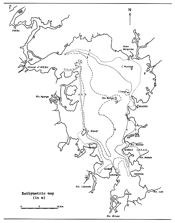
Fig. 9 LAKE TUMBA
(Matthes, 1964)
LAKE UPEMBA
| Geographical data (see Fig. 5) | ||
| Location: | Zaire - 8° 40'S; 26° 20'E situated in the Lualaba Floodplain/Lakes Complex (= Kamolondo Depression) | |
| Altitude: | 575 m | |
| Surface area: | 530 km2 | |
| Volume: | 0.9 km3 | |
| Depth: | 3.5 m (max); 1.7 m (mean) | |
| Max. length: | 40 km | |
| Max. width: | 20 km | |
| Major inflowing rivers: | Lualaba, Lufira | |
| Outflowing river: | Lualaba | |
| Physical and chemical data (after Van Meel, 1953) | ||
| Surface temperature: | 23.5–33.0°C | |
| Conductivity: | K20 145–255 μ S/cm | |
| pH: | 6.4–8.0 | |
| Ionic composition: | mg/l | |
| Ca | 20.6–42.3 | |
| Mg | 2.9–17.3 | |
| HCO3+CO3 | 109.8–203.1 | |
| SiO2 | 68.0–144.0 | |
| μ g/l | ||
| PO4-P | 31.0–65.0 | |
Fisheries data
Total annual catch: (Luvuande & Wosey, 1983)
| Year | Total catch (t) | |
| 1975 | 5 220 | |
| 1976 | 5 742 | |
| 1977 | 5 460 | |
| 1978 | 5 517 | |
| 1979 | 5 960 | |
| 1980 | 5 314 | |
| 1981 | 5 141 |
Potential annual yield: 2 650 t (50 kg/ha: Konare, 1984)
FLOODED FORESTS IN CENTRAL ZAIRE BASIN
| Geographical data (see Fig. 10) | |
| Location: | Zaire - 3°S-3°N; 16°–21°E |
| Altitude: | 330 m at Equator |
| Surface area of flooded forests in Zaire: (see Table 3) | |
| Special features: | see “Flooded forests in Mbandaka area” entry. |
Physical and chemical data of brown humic waters: see “Flooded forests in Mbandaka area” entry
Table 3. SURFACE AREA OF FLOODED FORESTS IN ZAIRE
| Permanent flood 1 | Seasonal flood (rainy season) | ||
| Mbandaka flooded forests 2 | (km2) | (km2) | |
| Giri plain | 5 850 | ||
| Mbandaka/Lake Tumba | 3 300 | ||
| Lulonga River | 140 | ||
| Ikelemba River | 200 | ||
| Busira River | 925 | ||
| Total | 10 415 | ||
| Lake Maji Ndombe flooded forests | |||
| West of lake | 2 000 | ||
| Yumbi | 900 | 19 000 3 | |
| Lotoi River, Lokoro River | 535 | 3 800 3 | |
| Total | 3 435 | 22 800 | |
| Makanga-Lisala flooded forests 2 | |||
| right bank | 20 800 | ||
| left bank | 2 450 | ||
| Sumba Island | 420 | ||
| Bolombo | 350 | ||
| Total | 24 020 | ||
| Total flooded forests 1 | 37 870 | ||
1 Surface area estimated from Operational Navigation Chart, scale 1:1 000 000 (USAF, 1975)
2 Vanden Bossche, 1986
3 Corsi, 1984a
Fisheries data: see “Flooded forests in Mbandaka area” entry
Potential annual yield: (t/yr)
Table 4. POTENTIAL ANNUAL YIELD OF FLOODED FORESTS IN ZAIRE
(CENTRAL BASIN)
| Flooded forests | Area km2 1 | 15 kg/ha 2 | 25 kg/ha 3 |
| Mbandaka | 10 415 | 15 623 | 26 038 |
| Lake Maji Ndombe | 3 435 | 5 152 | 8 587 |
| Makanga-Lisala | 24 020 | 36 030 | 60 050 |
| Total | 37 870 | 56 805 | 94 675 |
1 permanent flood (ONC-USAF, 1975)
2 Welcomme, 1989, pers.comm.: 15 kg/ha in brown acid waters
3 Corsi, 1984a: 25 kg/ha in brown acid waters.
Vanden Bossche (1986) estimates the exploitable potential annual yield of the area from Lake Tumba to Lisala (including Lake Tumba, Zaire River, Mbandaka and Makanga-Lisala flooded forests) at 100 000 to 120 000 t.
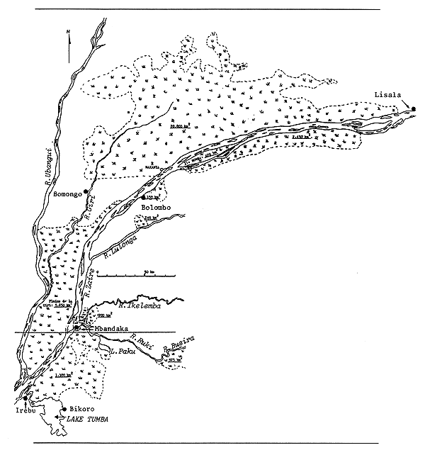
Fig. 10. FLOODED FORESTS IN CENTRAL ZAIRE BASIN FROM LAKE TUMBA TO LISALA
(Vanden Bossche, 1986)
FLOODED FORESTS IN MBANDAKA AREA
| Geographical data (see Fig. 10) | ||
| Location: | Central Zaire Basin - 1°S-1°N; 17°45'–18°20'E | |
| Altitude: | 330 m | |
| Surface area of flooded forests from Makanza to Irebu: (Vanden Bossche, 1986) | ||
| (km2) | ||
| Lulonga | 140 | |
| Giri plain, Zaire-Ubangi | 5 850 | |
| Ikelemba | 200 | |
| Busira (upstream Ruki) | 925 | |
| Mbandaka-Irebu-Lake Tumba | 3 300 | |
| Total | 10 415 | |
| Special features: | most of these areas are covered with permanent flooded (hydromorphic) forest. Main water level raisings occur on the bimodal type as Zaire River, although violent floods may occur any time of the year during heavy rains (Vanden Bossche, 1986). The typical “brown waters” occur in the flooded forest, where they are generated, in the medium-sized rivers (Ikelemba, Ruki, Lulonga, Giri), and in the shore-waters of the Zaire River, where they are discharged. | |
| Fluctuation in level in large flood forests: | ||
| Giri and Mbandaka, Lake Tumba: 1–3 m; the water being kept in the forest, the seasonal level fluctuation is lower than in the main river (Vanden Bossche, 1986). | ||
| Physical and chemical data of brown humic waters: | ||
| (after Berg, 1961; and Berg, cited by Gosse, 1963) The solubilization of the humic acid materials, produced by plant fragments in anaerobic and reducing conditions, gives the waters of the swamps a low pH and dark brown color. During neutralization in larger rivers, pH, oxygen content, turbidity and conductivity increase, while the brown colour reduces. | ||
| Temperature: | Forest channels and pools: | 20–25°C |
| Larger rivers and Zaire River: | 25–29°C | |
Other characteristics:
Table 5. PHYSICAL AND CHEMICAL CHARACTERISTICS:
RIVERS CENTRAL ZAIRE BASIN (brown humic waters)
(Berg, 1961) (cited in Compere & Symoens, 1987)
| Ikelemba | Ruki | Zaire River at Mbandaka | |
| Transparency (m) | 1.00 | 0.85 | 0.95 |
| Speed (km/h) | 3 | 2 | 3 |
| Temperature (°C) | 25.1 | 27.5 | 27.0 |
| pH | 3.9 | 4.2 | 3.9 |
| Oxygen (mg/l) | 2.3 | 4.8 | 4.4 |
| (saturation %) | 27 | 58 | 52 |
| Acidity (ml) Na2, CO3, N/l | 1.20 | 0.90 | 1.40 |
| Alkalinity (ml) H2SO4, N/l | 0.00 | 0.00 | 0.00 |
| Conductivity (μS/cm) | 45 | 24 | 50 |
Table 6. PHYSICO-CHEMICAL CHARACTERISTICS: FOREST CHANNELS, CENTRAL ZAIRE BASIN
| Min. | Mean | Max. | |
| Temperature °C (surface, a.m.) | 21.5 | 23.3 | 24.7 |
| pH | 8.50 | 4.10 | 6.20 |
| Conductivity (K21 μS/cm) | 10.1 | 22.1 | 48.9 |
| Acidity (m c/l) | 0.26 | 0.87 | 1.73 |
| Oxygen (mg O2/l) | 13.2 | 56.4 | 86.8 |
| O2 (mg/l) | 0.3 | 2.3 | 3.8 |
| SiO2 (mg/l) | 1.0 | 5.5 | 8.6 |
| Fe total (mg/l) | 0.35 | 0.75 | 1.40 |
| NH3 (mg N/l) | 0.15 | 0.25 | 0.72 |
| NO3 (mg N/l) | 0.03 | 0.11 | 0.30 |
| Ca:Mg (mg Ca/l) | 0.1 | 0.5 | 1.1 |
| Na (mg/l) | 0.20 | 0.40 | 0.70 |
| K (mg/l) | 0.4 | 1.1 | 2.5 |
| Cl (mg/l) | 0.2 | 0.7 | 1.0 |
| Fisheries data | |||
| No. of fish species: | Among the 408 sp. cited by Gosse, (1963) (see Zaire River entry), some do not enter in brown waters; others are endemic and/or specialized to brown waters. | ||
| Specialized families: | Protopteridae, Polypteridae, Notopteridae, Clariidae, Anabantidae, Channidae. | ||
| Main fish species in brown waters: (see Table 7 on following page) | |||
| Main catches from brown waters, Mbandaka area: (after Vanden Bossche, 1986) | |||
| % of total catch | |||
| Good fishing season: | Channidae | 23% | |
| Clariidae | 16% | ||
| Cichlidae | 8% | ||
| Poor fishing season: | Clariidae | 20% | |
| Protopteridae | 14% | ||
| Channidae | 10% | ||
| Mormyridae | 7% | ||
| Annual catch and effort: | |||
| 2 880 t (=0.9 t/fisherman) in 1986, in Ruki River, Ikelemba River and tributaries, Mbandaka area (Vanden Bossche, 1986) | |||
| Potential annual yield of flooded forests: (t/yr) | |||
| Area km2 | 15 kg/ha* | 25 kg/ha** | |
| Busira | 925 | 1 387 | 2 312 |
| Lake Tumba-Mbandaka | 3 300 | 4 950 | 8 250 |
| Ikelemba | 200 | 300 | 500 |
| Giri plain | 5 850 | 8 775 | 14 625 |
| Lulonga | 140 | 210 | 350 |
| Total | 15 622 | 26 037 |
* Welcomme, 1980, pers.comm.: 15 kg/ha in brown/acid waters
** Corsi, 1984a: 25 kg/ha in brown/acid waters
Table 7. MAIN FISH SPECIES IN BROWN HUMIC WATERS
(Ikelemba River, Ruki River, flooded forest between Mbandaka and Lake Tumba)
(Vanden Bossche, 1986)
| Families | Rivers | Forests | Swamps |
| Protopteridae | - | - | Protopterus dolloi |
| Polypteridae | - | - | Polypterus sp. |
| Clupeidae | - | - | - |
| Osteoglossidae | - | - | - |
| Notopteridae | Papyrocranus afer | Papyrocranus afer | Papyrocranus afer |
| Xenomystus nigri | Xenomystus nigri | Xenomystus nigri | |
| Mormyridae | Gnathonemus sp. | Gnathonemus sp. | Gnathonemus sp. |
| Marcusenius sp. | - | - | |
| Petrocephalus sp. | Petrocephalus sp. | Petrocephalus sp. | |
| - | Stomatorhinus sp. | Stomatorhinus sp. | |
| Phractolaemidae | - | - | Phractolaemus ansorgii |
| Hepsetidae | Hepsetus odoe | Hepsetus odoe | - |
| Characidae | Alestes sp. | Alestes sp. | - |
| Bathyaethiops sp. | - | - | |
| Bryconaethiops sp. | Bryconaethiops sp. | - | |
| Alestopetersius sp. | - | - | |
| Hydrocynus vittatus | - | - | |
| Distichodontidae | Distichodus sp. | - | - |
| Xenocharax sp. | - | - | |
| Citharinidae | Citharinus gibbosus | - | - |
| Cyprinidae | Barbus sp. | Barbus sp. | Barbus sp. |
| Raimas sp. | - | - | |
| Bagridae | Auchenoglanis punctatus | Auchenoglanis punctatus | Auchenoglanis punctatus |
| Clariidae | Clarias gariepinus | Clarias gariepinus | Clarias gariepinus |
| - | Clarias sp. | Clarias sp. | |
| - | Clariallabes sp. | Clariallabes sp. | |
| - | Channallabes sp. | Channallabes sp. | |
| Schilbeidae | Schilbe sp. | - | - |
| Mochokidae | Synodontis sp. | Synodontis sp. | - |
| Malapteruridae | Malapterurus electricus | Malapterurus electricus | Malapterurus electricus |
| Centropomidae | - | - | - |
| Cichlidae | Hemichromis sp. | Hemichromis sp. | Hemichromis sp. |
| “tilapia” | “tilapia” | - | |
| Anabantidae | Ctenopoma sp. | Ctenopoma sp. | Ctenopoma sp. |
| Channidae | Channa obscura | Channa obscura | Channa obscura |
ARUWIMI/ITURI RIVER
| Geographical data | |
| Source: | near Lake Albert in Zaire |
| Total length: | 1 030 km |
| 650 km - Upper course (Ituri) | |
| 380 km - Lower course (Aruwimi) | |
| Countries traversed: | Zaire |
| Discharges to: | Congo/Zaire River at Basoko |
ITIMBIRI RIVER
| Geographical data | |
| Source: | near Sasi, Zaire |
| Total length: | 535 km |
| 315 km - Upper course (Ribi) | |
| 220 km - Lower course (Itimbiri) | |
| Countries traversed: | Zaire |
| Discharges to: | Congo/Zaire River at Basoko |
KASAI/KWA RIVER
(International water)
| Geographical data | ||
| Source: | near Villa Luso, Angola (Kasai) | |
| Altitude: | 1 500 m | |
| Total length: | 1 735 km total | |
| (last 85 km, from Kasai-Lukenie/Fimi confluence to Congo/Zaire confluence, called Kwa) | ||
| Countries traversed: | Angola, Zaire | |
| Major tributaries: | ||
| Lubilash/Sankuru | 1 150 km | |
| Kwango | 750 km | |
| Kwilu | 960 km | |
| Lukenie/Fimi | 1 060 km | |
| Discharges to: | Congo/Zaire River at Kwamouth | |
| Special features: | Lake Maji Ndombe discharges into Congo/Zaire through the Fimi and Kwa Rivers. In Angola, one tributary (the Luachino River) is impounded by the small 8-m-high Luachino Dam. | |
LOMANI RIVER
| Geographical data | |
| Source: | Congo/Zaire - Zambezi divide |
| Total length: | 1 280 km |
| Discharges to: | Isanga, where it joins the Congo/Zaire. |
LUALABA RIVER
| Geographical data | |
| Source: | near Mwepo |
| Altitude: | 1 540 m |
| Total length: | 1 400 km to Kisangani, where its name changes to Congo/Zaire River. It is the main headwater of the Congo/Zaire. |
| Major tributaries: | Luvua (350 km), Lufira (630 km), Lukuga (310 km), Elila (400 km), Lindi (515 km), Lowa (390 km), Ulindi (450 km) |
| Discharges to: | (becomes) Congo/Zaire River |
| Special features: | Nzilo and Mwadingusha Reservoirs, Lufira swamps and Lualaba Floodplain/Lakes Complex (Kamulondo Depression). |
LUAPULA RIVER
(International water)
| Geographical data (see Fig. 7) | |
| Source: | Lake Bangweulu, Zambia |
| Altitude: | 1 140 m |
| Surface area: | 1 500 km2 Floodplain (Zaire+Zambia) (Welcomme, 1972) |
| 2 400 km2 River+Floodplain (Zaire+Zambia) (Konare, 1984) | |
| approximately 50% in Zaire | |
| Total length: | 560 km |
| Countries traversed: | Zaire, Zambia |
| Discharges to: | Lake Mweru |
| Special features: | the Luapula flows through an extensive swamp system which occupies the Kifukula Depression. This stretches from Johnson Falls to Lake Mweru, a distance of some 160 km and a width of 5–18 km. The total area of the swamp is 1 500 km2 during the wet season, when a depth of between 5–10 m is attained. The extent of the flooding varies from year to year. Larger permanent lakes on the floodplain include Lakes Kifikula and Kitshomponshi in Zaire and Lake Mofwe in Zambia. |
| Physical and chemical data: | |
| Conductivity: | 150–180 μ S/cm; 24.5 μ S/cm (Toews, pers.comm.) |
| pH: | 6.2 |
Fisheries data
Total annual catch and effort: in Zaire
| Year | Total catch (t) | No.of fishermen | No.of boats | Source |
| 1932 | 706* | - | - | FAO, 1983c |
| 1933–46 | - | - | - | - |
| 1847 | 4 000* | - | - | FAO, 1983c |
| 1948–51 | - | - | - | - |
| 1952 | 9 400* | - | - | - |
| 1953–56 | - | - | - | - |
| 1957 | 14 094* | - | - | - |
| 1958 | 13 600* | - | - | FAO, 1983c |
| 1959 | - | - | - | - |
| 1960 | 14 000* | - | - | - |
| 1961–81 | - | - | - | - |
| 1983 | 8 804 | 2 850 | 2 628 | Konare, 1984 |
| 1983 | 2 000–3 000 | - | - | FAO, 1983c |
| Potential annual yield: | |
| 10 000 t - River+Floodplain, Zaire + Zambia | |
| 5 000 t - River+Floodplain, Zaire (Konare, 1984) (FAO, 1983c) | |
| Productivity: | 40 kg/ha (cited by FAO, 1983c) |
| Main Reference: | De Kimpe, 1964 |
LULONGA RIVER
| Geographical data (see Fig. 10) | |
| Source: | Zaire |
| Altitude: | 457 m |
| Total length: | 705 km total |
| 515 km - Upper course (Maringa tributary) | |
| 190 km - Lower course (Lulonga) | |
| Countries traversed: | Zaire |
| Major tributaries: | Lopori (470 km) which joins Maringa at Basankusu to form Lulonga |
| Discharges to: | Congo/Zaire River |
MONGALA RIVER
| Geographical data | |
| Source: | near Sogo |
| Total length: | 510 km total |
| 225 km - Upper course (Ebola tributary) | |
| 285 km - Lower course (Mongala) | |
| Countries traversed: | Zaire |
| Major tributaries: | Dua (225 km) and Likame (130 km), both of which have a common confluence with the Ebola to form the Mongala |
| Discharges to: | Congo/Zaire River |
RUKI RIVER
| Geographical data (see Fig. 10) | |
| Source: | near Katako - Kombe |
| Total length: | 930 km total |
| 650 km - Upper course (Tshuapa tributary) | |
| 280 km - Lower course (Ruki) | |
| Countries traversed: | Zaire |
| Major tributaries: | Lowela (560 km), which joins Tshuapa to form Ruki; Salonga; Momboyo/Luilaka (535 km) |
| Discharges to: | Congo/Zaire at Eala |
| Special features: | flooded forests in its lower course: see entry “Flooded Forests in Mbandaka Area” |
| Physical and chemical data (see Table 5, page 331) | |
| Fisheries data see entry “Flooded Forests in Mbandaka Area” | |
RUZIZI RIVER
(International water)
| Geographical data | |
| Source: | Lake Kivu |
| Total length: | about 150 km |
| Countries traversed: | Burundi, Rwanda, Zaire |
| Discharges to: | Lake Tanganyika |
| Physical and chemical data | |
| Conductivity: | Upper course K18 1 190 μ S/cm; Lower course K18 828 μS/cm |
| Ionic composition: | (Beauchamp, 1939) | (Dubois, 1958) | ||
| mg/l | mg/l | |||
| Na | 94.8 | 98.0 | ||
| K | 63.0 | 74.0 | ||
| Ca | 8.4 | 8.5 | ||
| Mg | 67.0 | 101.6 | ||
| HCO3+CO3 | 638.1 | 585.6 | ||
| Cl | 23.8 | 16.6 | ||
| SO4 | 17.8 | 9.0 | ||
| SiO2 | 9.0–9.8 | 8.0 |
SEMLIKI RIVER
(International water)
| Geographical data | ||||
| Source: | Zaire, Lake Edward/Idi Amin | |||
| Altitude: | 619 m | |||
| Countries traversed: | Uganda, Zaire | |||
| Discharges to: | Lake Albert/Mobutu | |||
| Physical and chemical data | ||||
| Conductivity: | K20 400–910 μS/cm (Beauchamp, 1956) | |||
| Ionic composition: | (EAFRO, 1952b) | (Van Der Ben, 1959) | ||
| mg/l | mg/l | |||
| Ca | 15.0 | - | ||
| HCO3+CO3 | 436.8 | 454.3 | ||
| Cl | - | 30.7 | ||
| SO4 | - | 36.4 | ||
| SiO2 | 24.0 | 3.8 | ||
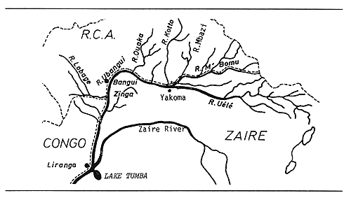
Fig. 11. UBANGI RIVER
(after Micha, 1973)
UBANGI/OUBANGUI RIVER
(International water)
| Geographical data (see Figs. 10 and 11) | |
| Source: | The Ubangi is formed by the confluence of the Uèlè and M'Bomu Rivers at Yakoma. The Uèlè rises in the mountains near Lake Albert, whereas the Bomu has its source on the frontier between Sudan, Central African Republic and Zaire. |
| Total length: | Mbomou/Bomu: 710 km (Zaire, Central African Republic) |
| Uèlè: 1 210 km (Zaire) | |
| Ubangi: 1 060 km (Congo, Central African Rep., Zaire) | |
| The longest continuous course (2 270 km) is the Uèlè + Ubangi. | |
| Drainage area: | 772 800 km2 |
| Countries traversed: | Congo, Central African Republic, Zaire |
| Major tributaries: | Kotto, Ouaka, Mbori, Lobaye, M'Bomu |
| Discharges to: | Congo/Zaire at Liranga |
| Flood regime: | August to December, max. in October (unimodal) |
| Low in March-April | |
| Flow at Bangui: | 800 to 11 000 m3/sec; mean: 4 000 m3/sec |
| Level variation: | 5.5 m (mean); 9 m (max.) |
| Physical and chemical data | |
| pH: | 7.0–7.2 (Depasse, 1956) |
| 6.2–6.9 (Micha, 1973) in Bangui | |
| Conductivity: | 19.5–56.0 μS/cm in Bangui (Micha, 1973) |
| Oxygen: | mean at Bangui: 6 mg/l, 75% saturation (Micha, 1973) |
| Fisheries data | |
| No. of species: | 233 in 25 families (Gosse, 1968; Micha, 1973) |
| Total annual catch: | |
| 2 000 t (Ubangi) | |
| 3 720 t (Uèlè) year unknown | |
| Potential annual yield: | |
| 3 000 t in Zaire (25 kg/ha) (Aubray, 1976) | |
ZAIRE/CONGO RIVER
(International water)
| Geographical data (see Fig. 1) | ||
| Source: | The longest continuous stream is: Chambezi River, Lake Bangweulu, Luapula River, Lake Mweru, Luvua River, Lualaba River. The Lualaba River changes its name to Congo/Zaire at Kisangani, 2 000 km from the mouth. It is navigable from the mouth to Matadi, and from Kinshasa to Kisangani. | |
| Altitude: | The highest source in Zaire is that of the Lualaba: 1 535 m asl. (Aubray, 1976) | |
| Total length: | 4 700 km from source Chambezi River in Zambia | |
| Drainage area: | 4 014 500 km2 | |
| Area of water: | (including Ubangui basin) | (Aubray, 1976) |
| Congo/Zaire | 17 000 km2 | |
| Tributaries of Congo/Zaire | 4 100 km2 | |
| Ubangi and tributaries | 1 300 km2 | |
| Other rivers | 8 500 km2 | |
| Kasai and tributaries | 3 100 km2 | |
| Countries traversed: | The basin covers parts of Angola, Burundi, Cameroon, Central African Republic, Congo, Rwanda, Tanzania, Zaire, Zambia. The Zaire/Congo River traverses Zambia, Zaire, Congo, Angola. | |
| Major tributaries: | Alima, Aruwimi, Elila, Itimbiri, Kwa, Lomami, Lowa, Lufira, Lukuga, Lulonga, Luvua, Mongala, Sangha, Ruki, Ubangi/Oubangui. | |
| Discharges to: | South Atlantic (6° S; 12° 30'E) | |
| Volume of discharge at mouth: 23–75 000 (mean 41 000) m3/sec (Aubray, 1976) | ||
| Suspended silt load: 5 | 0 500 000 t/yr (Welcomme, 1972) | |
| Flood regime: | Bimodal floods with peaks in May and December | |
| Special features: | Lakes: Tanganyika, Kivu, Bangweulu, Mweru, Maji Ndombe, Pool Malebo, Upemba, Tumba. Waterfalls: Portes d'Enfer, Wagenia, numerous cataracts; Dams on nearly all tributaries. Floodplains: Luapula/Kifakula depression, Lualaba/Kamalondo depression, Mbandaka flooded forests. | |
| Physical and chemical data | ||
| pH: | Both pH and conductivity vary considerably in the different water courses of the system. pH may be as low as 4.4 in flooded forests when the humic acids are not neutralized, and may be as high as 7.8 (Gosse, 1963) in the Zaire River main stream when the humic acids are neutralized. 5.5 in upper course (Poll & Renson, 1948); 6.5–7.0 in middle course (Depasse, 1956); 7.05–7.8 Yangambi (middle course), mean 7.4 (Gosse, 1963) | |
| Oxygen: | Yangambi: 6.7–8.2; mean: 7.2 mg/l (Gosse, 1963) Oxygen concentration is low at low pH (4–5), and higher at higher pH (7–8) (Compere & Symoens, 1987) | |
| Temperature: | Yangambi: 27.3° C (Gosse, 1963) | |
| Conductivity: | ||
| Yangambi, middle river: | K21 37.9–76.7 (mean 56.6) μS/cm | |
| Shore (middle course): | K21 37.1–59.0 (mean 47.0) μS/cm (Gosse, 1963) | |
| Luapula (upper course): | K20 44–108 μS/cm (Welcomme, 1972) | |
Table 8. PHYSICO-CHEMICAL CHARACTERISTICS OF RIVERS
OF THE CENTRAL ZAIRE BASIN
(Berg, 1961) (cited in Compere & Symoens, 1987)
| Mongala | Ikelemba | Ruki | Zaire at Mbandaka | ||
| shore | centre | ||||
| Transparency (m) | 1.40 | 1.00 | 0.85 | 0.95 | 0.70 |
| Speed (km/h) | 5 | 3 | 2 | 3 | 3 |
| Temperature (°C) | 25.0 | 25.1 | 27.5 | 27.0 | 28 |
| pH | 5.8 | 3.9 | 4.2 | 3.9 | 7.4 |
| Oxygen (mg/l) | 2.3 | 2.3 | 4.8 | 4.4 | 6.7 |
| (saturation %) | 27 | 27 | 58 | 52 | 82 |
| Acidity (ml) Na2, CO3, N/1 | 0.55 | 1.20 | 0.90 | 1.40 | 0.25 |
| Alkalinity (ml) H2SO4, N/1 | 0.08 | 0.00 | 0.00 | 0.00 | 0.43 |
| Conductivity (μS/cm) | 20 | 45 | 24 | 50 | 56 |
| Type of water * | (b) | (a) | (a) | (a) | (c) |
| Ionic composition: | (Meybeck, 1978) | (Gosse, 1963)* | |||
| mg/l | mg/l | ||||
| Ca | 2.40 | 6.4–12.1 | (mean: 8.1) | ||
| Mg | 1.25 | ||||
| Na | 1.70 | 2.2–4.9 | (mean: 3.6) | ||
| K | 1.10 | 1.6–2.5 | (mean: 1.9) | ||
| HCO3 | 11.2 | - | |||
| Cl | 2.85 | 1.5–2.7 | (mean: 2.0) | ||
| SO4 | 2.95 | - | |||
| SiO2 | 9.80 | - | |||
* Yangambi, middle Zaire River
Fisheries data
No. of fish species: 408 indigenous fish species in middle Zaire River,
distributed in 24 families and 101 genera (Gosse, 1963).
(See Table 9.)
Table 9. FISH SPECIES IN MIDDLE ZAIRE RIVER
| Yangambi | Malebo Pool | Central basin | ||||
| Families | Species | % | Species | % | Species | % |
| Protopteridae | 2 | 0.8 | 2 | 0.8 | 2 | 0.6 |
| Polypteridae | 6 | 2.5 | 5 | 2.1 | 7 | 1.7 |
| Clupeidae | 6 | 2.5 | 1 | 1.7 | 9 | 2.2 |
| Mormyridae | 43 | 18.2 | 46 | 19.6 | 75 | 18.5 |
| Notopteridae | 1 | 0.4 | 2 | 0.8 | 2 | 0.6 |
| Phractolaemidae | 1 | 0.4 | 1 | 0.1 | 1 | 0.3 |
| Pantodontidae | 1 | 0.4 | 1 | 0.1 | 1 | 0.3 |
| Characidae | 26 | 10.5 | 17 | 7.2 | 35 | 8.4 |
| Citharinidae | 27 | 11.3 | 23 | 9.8 | 38 | 9.3 |
| Cyprinidae | 29 | 12.1 | 24 | 10.2 | 52 | 12.8 |
| Clariidae | 15 | 6.3 | 11 | 1.7 | 23 | 5.7 |
| Schilbeidae | 7 | 2.9 | 5 | 2.1 | 13 | 3.2 |
| Bagridae | 10 | 4.2 | 17 | 7.2 | 27 | 6.7 |
| Mochokidae | 20 | 8.4 | 24 | 10.2 | 36 | 8.9 |
| Amphiliidae | 5 | 2.1 | 3 | 1.3 | 12 | 3.0 |
| Malapteruridae | 1 | 0.4 | 1 | 0.1 | 1 | 0.3 |
| Cyprinodontidae | 5 | 2.1 | 7 | 3.0 | 11 | 2.7 |
| Cichlidae | 14 | 5.9 | 17 | 7.2 | 32 | 7.6 |
| Centropomidae | 1 | 0.4 | 1 | 0.4 | 1 | 0.3 |
| Eleotridae | 1 | 0.4 | 1 | 3.4 | 1 | 0.3 |
| Anabantidae | 10 | 4.2 | 10 | 4.3 | 12 | 3.0 |
| Ophiocephalidae | 1 | 0.4 | 1 | 0.4 | 2 | 0.6 |
| Mastacembelidae | 5 | 2.1 | 8 | 3.4 | 11 | 2.7 |
| Tetraodontidae | 2 | 0.8 | 4 | 1.7 | 4 | 1.0 |
| Total | 239 | 235 | 408 | |||
One family (Osteoglossidae) and one species (Heterotis niloticus), introduced in Zaire Basin (Ubangi River) in 1960 (Micha, 1973) must be added; Heterotis niloticus already commonly caught in Mbandaka area (Vanden Bossche, 1986).
Main fish species in Zaire River, central basin: (Vanden Bossche, 1986) (See Table 10 on following page)
Table 10. MAIN FISH SPECIES IN ZAIRE RIVER, CENTRAL BASIN
(Vanden Bossche, 1986)
| Families | Pelagiques* | Benthiques** | Eaux littorales** |
| Protopteridae | - | - | Protopterus dolloi |
| Polypteridae | - | (Polypterus sp.) | Polypterus sp. |
| Clupeidae | Odaxothrissa sp. | - | Odaxothrissa sp. |
| Osteoglossidae | - | Heterotis niloticus | Heterotis niloticus |
| Notopteridae | - | - | Papyrocranus afer |
| Xenomystus nigri | |||
| Mormyridae | - | Gnathonemus sp. | Gnathonemus sp. |
| - | - | Genyomyrus sp. | |
| - | Mormyrus caballus | Mormyrus caballus | |
| - | Mormyrus sp. | Mormyrus sp. | |
| - | Mormyrops deliciousus | Mormyrops deliciousus | |
| - | Marcusenius sp. | Marcusenius sp. | |
| - | Petrocephalus sp. | Petrocephalus sp. | |
| Phractolaemidae | - | - | Phractolaemus ansorgii |
| Hepsetidae | - | - | - |
| Characidae | Alestes sp. | - | Alestes sp. |
| - | - | Bathyaethiops sp. | |
| Bryconaethiops sp. | - | Bryconaethiops sp. | |
| Alestopetersius sp. | - | Alestopetersius sp. | |
| Hydrocynus goliath | - | - | |
| Hydrocynus vittatus | - | Hydrocynus vittatus | |
| Distichodontidae | - | Distichodus antonii | Distichodus antonii |
| - | Distichodus sp. | Distichodus sp. | |
| Eugnathichthys sp. | - | Eugnathichthys sp. | |
| - | - | Xenocharax sp. | |
| Citharinidae | Citharinus gibbosus | Citharinus gibbosus | Citharinus gibbosus |
| Cyprinidae | Barbus cardozoi | Barbus cardozoi | Barbus cardozoi |
| - | Barbus sp. | Barbus sp. | |
| - | Labeo velifer | Labeo velifer | |
| Raiamas sp. | - | Raiamas sp. | |
| Bagridae | - | Chrysichthys cranchii | Chrysichthys cranchii |
| - | Chrysichthys sp. | Chrysichthys sp. | |
| - | Auchenoglanis occidentalis | Auchenoglanis occidentalis | |
| - | - | Auchenoglanis | |
| punctatus | |||
| - | Gephyroglanis sp. | Gephyroglanis sp. | |
| Clariidae | - | Heterobranchus longif. | Heterobranchus longif. |
| - | - | Clarias gariepinus | |
| Schilbeidae | Eutropius sp. | - | Eutropius sp. |
| Schilbe sp. | - | Schilbe sp. | |
| Mochokidae | - | Synodontis sp. | Synodontis sp. |
| Malapteruridae | - | Malapterurus electricus | Malapterurus electricus |
| Centropomidae | Lates niloticus | Lates niloticus | - |
| Cichlidae | - | - | Hemichromis sp. |
| - | - | “Tilapia” | |
| Anabantidae | - | - | Ctenopoma sp. |
| Channidae | - | - | Channa obscura |
* NEUTRALIZED WATERS
** NEUTRALIZED AND PARTLY NEUTRALIZED WATERS
No. of fishermen: 40–50 000 in Zaire River (Corsi, 1984b)
Main catches: (See Table 11)
Table 11. RELATIVE PERCENTAGE OF FAMILIES CAUGHT IN MBANDAKA AREA
AND SOLD IN MBANDAKA MARKETS
(Vanden Bossche, 1986)
A=during good fishing season (Feb.-March, 1986)
B=during poor fishing season (Nov.-Dec., 1985)
| Families | A | B |
| Protopteridae | 1 | 14* |
| Polypteridae | <1* | 1* |
| Mormyridae | 4.5 | 7* |
| Characidae | 2.5** | 4** |
| Hepsetidae | 1* | <1* |
| Citharinidae | 2 | 4 |
| Distichodontidae | 13** | 12** |
| Cyprinidae | 10** | 5.5** |
| Schilbeidae | <1** | <1 |
| Clariidae | 16* | 20* |
| Bagridae | 12** | 10** |
| Mochokidae | <1 | 1.5** |
| Cichlidae | 5* | <1* |
| Clupeidae | - | 1** |
| Notopteridae | <1 | <1 |
| Centropomidae | 1** | - |
| Malapteruridae | 2** | 1 |
| Phractolaemidae | - | <1* |
| Anabantidae | - | <1* |
| Channidae | 23* | 10* |
| Osteoglossidae | 2** | 3** |
| Fingerlings (Miscellaneous) | 3.5*** | 4 |
| Total | 100% | 100% |
* = catches mainly in Zaire River tributaries: Ruki River and adjacent flooded forest channels (humic, acid, brown waters)
** = catches mainly in Zaire River mainstream (neutralized waters)
*** = mainly cichlidae
| Fishing seasons: (See Fig. 12 on following page) | ||
| Mean annual catch per fisherman: (Corsi, 1984b) | ||
| 800–1 000 kg - 60 km upstream to 120 km downstream Kisangani | ||
| 1 300–1 500 kg - 120 km downstream Kisangani to Basoko | ||
| 2 000–2 200 kg - Basoko to Lulonga | ||
| 1 500–1 800 kg - Mbandaka area | ||
| 1 300–1 700 kg - Irebu to Bolobo | ||
| 600–700 kg - Pool Malebo | ||
| Total annual catch: in Zaire (t) | ||
| Zaire River | 47 500 * | |
| Tributaries of Zaire River | 10 200 | |
| Ubangi and tributaries | 5 720 | |
| Kasai and tributaries | 2 750 | |
| Other rivers | 12 750 | |
| Total (in 1961) | 78 920 | |
* in Zaire River in 1984: 70–75 000 t (Corsi, 1984b)
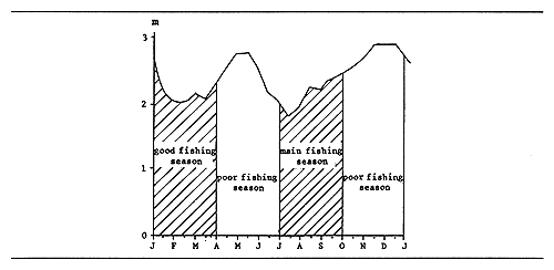
Fig. 12. ZAIRE RIVER: BIMODAL MEAN FLOW AT MBANDAKA (1932–1983)
related to fishing seasons
(after Corsi, 1984)
| Potential annual yield: | |
| 150 000 t in Zaire - Zaire River and its tributaries (smaller rivers, floodplains) (Corsi, 1984b) | |
| 50 000 t in Zaire River, itself, excluding tributaries (rough estimate based on several authors) | |
| Main references for fish determination and taxonomy in Zaire: | |
| Gosse, 1968; | |
| Lambert, 1961; | |
| Matthes, 1964; | |
| Poll, 1939, 1957; | |
| Poll & Gosse, 1963 | |
MWADINGUSHA (= TSHANGALELE) (= LUFIRA) RESERVOIR
| Geographical data | |
| Location: | Zaire - 10° 54'S; 27° 03'E |
| Altitude: | 1 100 m |
| Date closed: | 1938 |
| Surface area: | 446 km2 (max) |
| Depth: | 14 m (max); 2.6 m (mean) |
| Max. length: | 25 km |
| Max. width: | 24 km |
| Major inflowing river: | Lufira |
| Outflowing river: | Lufira |
| Shoreline: | 170 km |
| Volume: | 1.063 km3 |
| Level variation: | 1 to 3 m |
| Physical and chemical data: | |||
| Surface temperature: | 25–26° C in rainy season (Konare, 1984) | ||
| Conductivity: | K20 128–309 μ S/cm | ||
| pH: | 7.1–8.2; 7.5–8.4 (Konare, 1984) | ||
| Oxygen: | 15.0 mg/l, Jan.; 2.0, April; 21.0, July (Konare, 1984) | ||
| Ionic composition: | mg/l | ||
| Na | 3.07–6.0 | ||
| K | 0.78–1.56 | ||
| Ca | 11.04–49.07 | ||
| Cl | 0.71–2.49 | ||
| SO4 | 0.19–5.0 | ||
| SiO2 | 14.06–21.06 | ||
| NO3-N | 3.01–11.02 | ||
| PO4-P | 9–18.00 | ||
| Fisheries data | ||
| No. of fish species: | 6 families, 17 species, from Lufira River | |
| Main catches: | (fishing interest): Tilapia melanopleura, Oreochromis macrochir, Serranochromis kafuensis, Clarias gariepinus (Konare, 1984) | |
| Total annual catch and effort: | ||
| Year | Total catch (t) | No.of fishermen | No.of boats |
| 1953 | 314 | - | - |
| 1954 | 2 354 | - | - |
| 1955 | 7 991 | - | - |
| 1956 | 674 | - | - |
| 1957 | 1 359 | - | - |
| 1958 | 4 223 | - | - |
| 1959–60 | - | - | - |
| 1961 | 6 115 | - | - |
| 1962–77 | - | - | - |
| 1978 | 1 500 | - | - |
| 1979–81 | - | - | - |
| 1982 | 4 350 | - | - |
| 1983 | 3 106* | 1 410 | 1 583 (Konare, 1984) |
* 1 606 t marketed fish + 1 500 t fishermen consumption
Potential annual yield: 4 460 t (100 kg/ha) (Konare, 1984)
NZILO (= NZILO I; = DELCOMMUNE) RESERVOIR
| Geographical data | |
| Location: | Zaire - 10° 40'S; 25° 40'E |
| Altitude: | 1 246.75 m at USL |
| Surface area: | 280 km2 |
| Depth: | 8.3 m (mean) (Konare, 1984) |
| Volume: | 1.733 km3 |
| Max. length: | 35 km |
| Max. width: | 15 km |
| Annual fluctuation in level: up to 9 m | |
| Major inflowing river: | Lualaba |
| Outflowing river: | Lualaba |
| Physical and chemical data | |
| Surface temperature: | 25–26° C (rainy season) |
| 5–10° C (dry season - April-July) (Konare, 1984) | |
| Conductivity: | K20 400 μ S/cm (Welcomme, 1972) |
| pH: | 7.7–8.5 |
| Oxygen: | 4.26 to 9.31 mg/l (Konare, 1984) |
| Fisheries data | |
| Fish species: | (fishing interest): (Konare, 1984) Oreochromis macrochir (main catches); Labeo sp.; Barbus sp.; Clarias gariepinus; Tilapia melanopleura; Serranochromis kafuensis. |
Total annual catch and effort:
| Year | Total catch (t) | No. of fishermen | No. of boats | Source |
| 1957 | 2 364 | - | - | |
| 1958–59 | - | - | - | |
| 1960 | 3 500 | - | - | |
| 1961 | 2 364 | - | - | |
| 1962–80 | - | - | - | |
| 1981 | 333* | - | - | Konare, 1984 |
| 1982 | 150* | - | - | Konare, 1984 |
| 1983 | 120* | - | - | Konare, 1984 |
| 1984 | - | 830 | 346 | Konare, 1984 |
Potential annual yield: 2 520 t (90 kg/ha) (Konare, 1984)
NZILO II (= MARINEL) RESERVOIR
| Geographical data | |
| Location: | Zaire - 10° 40'S; 25°E (immediately downstream from Nzilo I Dam) |
| Major inflowing river: | Lualaba (outflow from Nzilo I dam) |
| Outflowing river: | Lualaba |
7. BIBLIOGRAPHY
Aubray, 1976
Beadle, 1981
Beauchamp, 1939, 1956
Berg, 1961
Compere & Symoens, 1987
Corsi, 1984a,b
Corsi et al., 1986
Coulter, 1981
Degens et al., 1971
De Kimpe, 1960, 1964
Depasse, 1956
Dubois, 1958, 1959
EAFRO, 1952b, 1954
FAO, 1983c
Giudicelli et al., 1987
Gosse, 1963, 1968
Greenwood, 1964
Hanek et al., 1988
Jensen et al., 1983
Johannesson & Lamboeuf, 1989
Konare, 1984
Lambert, 1961
Luvuande & Wosey, 1983
Marlier, 1958
Matthes, 1964
Melack, 1976
Meybeck, 1978
Micha, 1973
Mikkola & Lindquist, 1989
Oglesby, 1977
Poll, 1939, 1957
Poll & Gosse, 1963
Poll & Renson, 1948
Proude, 1984
Reusens, 1987
Reyntjens, 1982
Stappers, 1914
Talling & Talling, 1965
Vakily, 1989
Vanden Bossche, 1986
Van Der Ben, 1959
Van Meel, 1953
Verbeke, 1957
Welcomme, 1972; 1979a,b
![]()
![]()
![]()